
Natural Resources
Conservation Service
-
Search


Major Land Resource Area or ecological site by name and/or ID.
PreviousSectionsNextGeneral information
Draft. A draft ecological site description is either incomplete or has not undergone quality control and quality assurance review.
MLRA notes
Major Land Resource Area (MLRA): 035X–Colorado Plateau
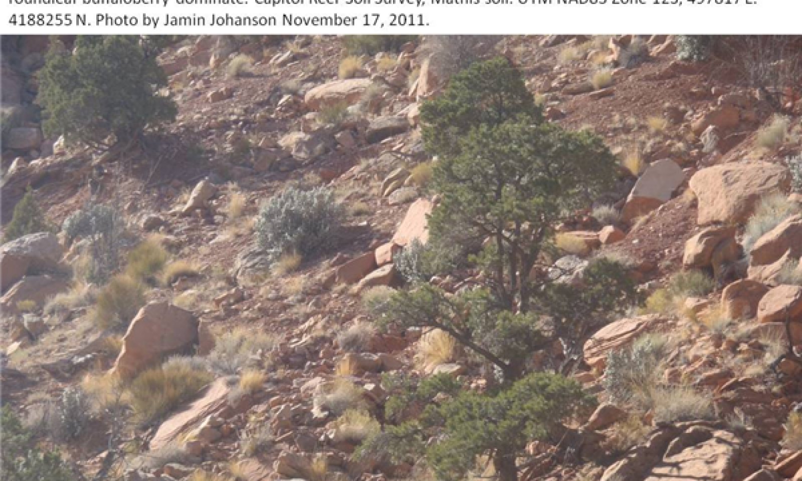
Site concept: This site occurs in the upland zone of the Colorado and Green River Plateaus Region (MLRA 35) in Southern Utah. It is found at elevations between 4000 and 7000 feet on 2-50% slopes, particularly on mountainsides, fan remnants and mesas. Average annual precipitation is 13 to 16 inches. The soils are typically deep and sandy with rock fragments making up about 50% of the soil volume throughout the profile. They formed in colluvium and alluvium derived from sandstone. The soil moisture regime is aridic ustic and the soil temperature regime is mesic. Two-needle pinyon is the dominant plant, and Utah juniper is also abundant. Roundleaf buffaloberry, Mormon tea, Indian ricegrass and Salina wildrye make up a significant portion of the understory. This site rarely burned under natural conditions. Non-native species have not yet been documented on this site.
Similar sites
R035XY317UT Upland Steep Stony Loam (Utah Juniper-Pinyon)
This site has similar soils, slopes and plant community. However, the soils are loamy skeletal rather than sandy, which support different understory species.
R035XY321UT Upland Stony Loam (Pinyon-Utah Juniper)
This site has similar soils, slopes and plant community. However, the soils are loamy skeletal rather than sandy, which support different understory species.
Table 1. Dominant plant species
Tree (1) Pinus edulis
(2) Juniperus osteospermaShrub Not specified
Herbaceous (1) Achnatherum hymenoides
(2) Leymus salinusPhysiographic features
Table 2. Representative physiographic features
Landforms (1) Mesa
(2) Fan remnant
(3) Mountain slope
Flooding frequency None Ponding frequency None Elevation 4000 – 7000 ft Slope 2 – 50 % Climatic features
The climate of this site is characterized by hot summers and cool winters. Average annual precipitation ranges from 13 to 16 inches. Large fluctuations in daily temperature are common, and precipitation varies greatly from month to month and from year to year.
Along with climate station data, modeled climate data (PRISM) was used to develop this section.Table 3 Representative climatic features
Frost-free period (average) 210 days Freeze-free period (average) 230 days Precipitation total (average) 20 in BarLineFigure 1. Monthly precipitation range
BarLineFigure 2. Monthly average minimum and maximum temperature
">Influencing water features
Due to its landscape position, this site is not typically influenced by streams or wetlands.
Soil features
The soils of this site are moderately deep or deep sands with high rock fragments on the soil surface and throughout the soil profile. They formed in alluvium and colluvium derived from sandstone. Textures are mostly loamy fine sands and fine sandy loams, but can also be loams. Water holding capacity ranges from 1.1 to 2.6 inches of water in the upper 40 inches of soil. The soil moisture regime is aridic ustic and the soil temperature regime is mesic.
This site has been correlated to soils in the following soil surveys:
UT633 - Canyonlands Area - Bluehon;
UT641 - Washington County Area - Mathis;
UT646 - Dixie National Forest - Mathis;
UT685 - Capitol Reef - Mathis;Table 4. Representative soil features
Parent material (1) Alluvium – sandstone
Surface texture (1) Very stony loamy fine sand
(2) Very stony fine sandy loam
(3) Stony loam
Family particle size (1) Sandy
Drainage class Well drained to somewhat excessively drained Soil depth 20 – 0 in Surface fragment cover <=3" 10 – 20 % Surface fragment cover >3" 30 – 40 % Available water capacity
(0-40in)1.1 – 2.6 in Calcium carbonate equivalent
(0-40in)0 – 10 % Electrical conductivity
(0-40in)0 – 4 mmhos/cm Sodium adsorption ratio
(0-40in)Not specified Soil reaction (1:1 water)
(0-40in)7.4 – 8.4 Subsurface fragment volume <=3"
(Depth not specified)10 – 20 % Subsurface fragment volume >3"
(Depth not specified)20 – 35 % Ecological dynamics
This site developed under Colorado Plateau climatic conditions and included natural influences of herbivory, and climate; however due to the remote location, broken topography, steep slopes (2-50%), and lack of perennial water sources this area rarely served as habitat for large herds of native herbivores. This site’s plant species composition is generally dominated by twoneedle pinyon and Utah juniper, with birchleaf mountain mahogany or similar shrubs abundant in the understory.
There is no evidence to indicate that this site historically maintained a short burn frequency. Until further research indicates that fire played a role in the ecosystem processes of this site, the state and transition model will not include fire as a disturbance mechanism in the reference state. However, due to modern disturbances such as brush treatments, invasive species, and OHV use, the resilience of the plant communities may be at risk. Disturbances that reduce the presence of perennial grasses result in an opportunity for invasive annuals to enter into the system. However, to this point invasive species have not been documented on this site.
Drought and insects appear to be the main driving factors in many of the Pinyon/Juniper communities of Utah. Betancourt et al. (1993), noted that Pinyon and Juniper woodlands in the southwest appear to be more susceptible to large die offs during droughts, than in other locations. As severe droughts persist, the Pinyon trees, being more susceptible to drought and insects, seem to die out, while the Utah juniper trees survive. Large die offs of pinyons due to insects and drought have not been recorded for this ecological site. However, given the tendency for pinions to be susceptible to insect and drought kill, managers should be aware of the possibility.
As vegetation communities respond to changes in management or natural occurrences, thresholds can be crossed, which usually means that a return to the previous state may not be possible without major energy inputs. The amount of energy input needed to affect vegetative shifts depends on the present biotic and abiotic features and the desired results. The following diagram does not necessarily depict all the transition and states that this site may exhibit, but it does show some of the most common plant communities that can occur on the site and the transition pathways among the communities. These plant communities may not represent every possibility, but they are the most prevalent and repeatable. As more data is collected, some of these plant communities will be revised or removed, and new ones may be added. None of these plant communities should necessarily be thought of as the “desired plant community. The main purpose for including any description of a plant community here is to capture the current knowledge and experience at the time of this revision.State and transition model
Custom diagramStandard diagram
Figure 3. State-and-Transition Model
More interactive model formats are also available. View Interactive Models
More interactive model formats are also available. View Interactive Models
Click on state and transition labels to scroll to the respective textEcosystem states
State 1 submodel, plant communities
State 1
Reference StateThis state represents the natural range of variability that historically dominated the dynamics of this ecological site. This state includes the biotic communities that would be expressed on the ecological site if all successional sequences were completed without modern disturbances under the present environmental conditions; natural disturbances are inherent in its development. This state is dominated by two-needle pinyon and Utah juniper with a diverse understory of shrubs, perennial grasses and forbs. The primary disturbance mechanisms for this site in the reference condition include drought and insects.
Reference State: Two-needle pinyon and Utah juniper woodland
Indicators: A community dominated by twoneedle pinyon and Utah juniper, where shrubs, and native perennial grasses and forb production is variable.
Feedbacks: Disturbances that may allow for the establishment of invasive species.
Community 1.1
Reference State
Figure 4. Phase 1.1
This plant community phase is characterized by an overstory canopy of two-needle pinyon and Utah juniper, with a shrub and perennial grass understory. Shrubs commonly seen include buffaloberry and Mormon tea. Grasses that typically inhabit this site include Indian ricegrass and Salina wildrye. Forb composition is variable. Other grasses and shrubs are present; however, species composition varies from one site to the next.
Figure 5. Annual production by plant type (representative values) or group (midpoint values)
Table 5. Annual production by plant type
Plant type Low
(lb/acre)Representative value
(lb/acre)High
(lb/acre)Grass/Grasslike 50 125 200 Tree 100 150 200 Shrub/Vine 30 65 100 Forb 5 15 25 Total 185 355 525 Table 6. Ground cover
Tree foliar cover 10-20% Shrub/vine/liana foliar cover 10-20% Grass/grasslike foliar cover 10-20% Forb foliar cover 0-10% Non-vascular plants 0% Biological crusts 0% Litter 0-10% Surface fragments >0.25" and <=3" 10-20% Surface fragments >3" 30-40% Bedrock 0% Water 0% Bare ground 10-20% Table 7. Canopy structure (% cover)
Height Above Ground (ft) Tree Shrub/Vine Grass/
GrasslikeForb <0.5 – 0-3% 0-5% 0-2% >0.5 <= 1 – 0-5% 2-5% 0-3% >1 <= 2 – 0-5% 2-5% 0-2% >2 <= 4.5 0-3% 5-10% 0-5% – >4.5 <= 13 5-15% 0-3% – – >13 <= 40 0-3% – – – >40 <= 80 – – – – >80 <= 120 – – – – >120 – – – – Additional community tables
Table 8. Community 1.1 plant community composition
Group Common name Symbol Scientific name Annual production () Foliar cover (%) Tree0 Trees 100–200 twoneedle pinyon PIED Pinus edulis 75–150 5–10 Utah juniper JUOS Juniperus osteosperma 15–100 1–8 roundleaf buffaloberry SHRO Shepherdia rotundifolia 15–45 1–3 Utah serviceberry AMUT Amelanchier utahensis 5–30 0–2 mormon tea EPVI Ephedra viridis 5–30 1–2 Grass/Grasslike1 Grass 50–200 saline wildrye LESAS Leymus salinus ssp. salinus 15–150 1–10 Indian ricegrass ACHY Achnatherum hymenoides 10–50 1–4 blue grama BOGR2 Bouteloua gracilis 5–40 1–3 James' galleta PLJA Pleuraphis jamesii 5–40 1–3 Grass, perennial 2GP Grass, perennial 0–30 0–2 Grass, annual 2GA Grass, annual 0–20 0–2 Sandberg bluegrass POSE Poa secunda 0–15 0–1 Geyer's sedge CAGE2 Carex geyeri 0–15 0–1 needle and thread HECO26 Hesperostipa comata 0–15 0–1 Forb2 Forbs 5–25 Forb, perennial 2FP Forb, perennial 0–25 0–2 Forb, annual 2FA Forb, annual 0–20 0–2 Brenda's yellow cryptantha CRFL5 Cryptantha flava 0–10 0–1 stemless four-nerve daisy TEACA2 Tetraneuris acaulis var. acaulis 0–10 0–1 fineleaf hymenopappus HYFI Hymenopappus filifolius 0–5 0–1 rayless tansyaster MAGR2 Machaeranthera grindelioides 0–5 0–1 lobeleaf groundsel PAMU11 Packera multilobata 0–5 0–1 Utah penstemon PEUT Penstemon utahensis 0–5 0–1 stemless mock goldenweed STAC Stenotus acaulis 0–5 0–1 crispleaf buckwheat ERCO14 Eriogonum corymbosum 0–5 0–1 woolly locoweed ASMO7 Astragalus mollissimus 0–5 0–1 Shrub/Vine3 Shrubs 30–100 roundleaf buffaloberry SHRO Shepherdia rotundifolia 5–45 1–3 mormon tea EPVI Ephedra viridis 5–45 1–3 Gambel oak QUGA Quercus gambelii 0–40 0–3 Shrub (>.5m) 2SHRUB Shrub (>.5m) 0–35 0–3 Utah serviceberry AMUT Amelanchier utahensis 0–20 0–2 Bigelow sage ARBI3 Artemisia bigelovii 0–20 0–2 littleleaf mountain mahogany CEIN7 Cercocarpus intricatus 0–20 0–2 Fremont's mahonia MAFR3 Mahonia fremontii 0–20 0–2 rubber rabbitbrush ERNAN5 Ericameria nauseosa ssp. nauseosa var. nauseosa 0–10 0–1 singleleaf ash FRAN2 Fraxinus anomala 0–10 0–1 broom snakeweed GUSA2 Gutierrezia sarothrae 0–10 0–1 Interpretations
Animal community
--Livestock and Wildlife Grazing--
This site provides fair/poor grazing conditions for livestock and wildlife during spring, summer, and fall when in good ecological condition due to sparse vegetative cover. This site often lacks natural perennial water sources, which can influence the suitability for livestock and wildlife grazing. Care should be taken to maintain the native perennial grasses and shrubs due to the poor suitability for re-seeding or restoring this site. Reseeding and/or restoration are difficult due to the extreme temperatures and variability in time and amount of precipitation. This site occurs in elk, mule deer, and big horn sheep habitat; however in many places the populations will be small and have little grazing impact on the site.
The plant community is primarily shrubs, including Utah serviceberry, gambel oak, alderleaf mountain mahogany, antelope bitterbrush, mountain big sagebrush, and green jointfir. These shrubs provide fair browse for cattle, sheep, goats, elk, mule deer, and bighorn sheep. Grasses include mutton bluegrass and Indian ricegrass, and provide fair grazing conditions for all classes of livestock and wildlife. Utah juniper and pinyon pine provide good cover for livestock and wildlife; mule deer and goats may also graze these trees. Forb composition and annual production depends primarily on precipitation amounts and thus is challenging to use in livestock grazing management decisions. However, forb composition should be monitored for species diversity, as well as poisonous or injurious plant communities which may be detrimental to livestock if grazed. Before making specific grazing management recommendations, an onsite evaluation must be made.
--References--
Relative Forage Preference of Plants for Grazing Use by Season: Plants commonly found in Major Land Resource Area D35 --The Colorado Plateau. 2007
Stubbendieck, J., S. L. Hatch, and C. H. Butterfield. 1997. North American range plants. Lincoln, NE: University of Nebraska Press. 501p.
USDA, Forest Service. 2007. Fire effects information: plant species life form. Available at http://www.fs.fed.us/database/feis/plants/index.html. Accessed 7 August 2007.
Other information
--Poisonous/Toxic Plant Communities--
Toxic plants associated with this site include woolly locoweed and broom snakeweed. Woolly locoweed is toxic to all classes of livestock and wildlife. This plant is palatable and has similar nutrient value to alfalfa, which may cause animals to consume it even when other forage is available. Locoweed contains swainsonine (indolizdine alkaloid) and is poisonous at all stages of growth. Poisoning will become evident after 2-3 weeks of continuous grazing and is associated with 4 major symptoms: 1) neurological damage, 2) emaciation, 3) reproductive failure and abortion, and 4) congestive heart failure linked with “high mountain disease”. Broom snakeweed contains steroids, terpenoids, saponins, and flavones that can cause abortions or reproductive failure in sheep and cattle, however cattle are most susceptible. These toxins are most abundant during active growth and leafing stage. Cattle and sheep will generally only graze broom snakeweed when other forage is unavailable, typically in winter when toxicity levels are at their lowest.
Potentially toxic plants associated with this site include some buckwheat species, which may accumulate selenium, but only when growing on selenium enriched soils. These plants, when consumed will cause alkali disease or chronic selenosis, which affects all classes of livestock (excluding goats). Typically animals consuming 5-50 ppm selenium will develop chronic selenosis and animals consuming greater than 50 ppm selenium will develop acute selenosis. Clinical signs include lameness, soughing of the hoof, hair loss, blindness, and aimless wondering. Horses tend to develop what is called a “bob” tail or “roached” main due to breakage of the long hairs.
--Invasive Plant Communities--
Generally as ecological conditions deteriorate and perennial vegetation decreases due to disturbance (fire, over grazing, drought, off road vehicle overuse, erosion, etc.) annual forbs and grasses will invade the site. Of particular concern in semi-arid environments are the non-native annual invaders including cheatgrass, Russian thistle, kochia, halogeton, and annual mustards. The presence of these species will depend on soil properties and moisture availability; however, these invaders are highly adaptive and can flourish in many locations. Once established, complete removal is difficult but suppression may be possible. On well developed Utah juniper and pinyon pine communities soils are complete occupied by lateral roots, which inhibit an herbaceous understory as well as annual invasions. However once these sites are disturbed and pinyon-juniper communities begin to decline invasion is possible.
--Fire Ecology--
The ability for an ecological site to carry fire depends primarily on the present fuel load and plant moisture content—sites with small fuel loads will burn more slowly and less intensely than sites with large fuel loads. Many plant communities in the Colorado Plateau may have evolved without the influence of fire. However a year of exceptionally heavy winter rains can generate fuels by producing heavy stands of annual forbs and grasses. When fires do occur, the effect on the plant community may be extreme due to the harsh environment and slow rate of recovery.
The pinyon and Utah juniper communities in the Colorado Plateau on shallow soils are unique. These sites have a natural occurring fire regime, but this is not understood very well due to the difficulty in reconstructing fire histories in these ecosystems. The difficulty results from a lack of living fire-scarred trees in this area. These trees can support stand-replacing fires, though historically, fires were likely a mixture of surface and crown fires with intensities and frequencies dependent on site productivity. Most research agrees that historic fire return intervals are at a minimum 100 years, indicating that fire may have not played an important role in community dynamics. Fires are more common when trees are stressed or dead due to drought and/or beetle infestations. Pinyon-juniper stands reestablish either by seeds dispersed from adjacent unburned patches or by unburned seeds found at the burn site. Continuous (every 20-40 years) burning of these ecological sites can result in shrub dominated communities, due to the relatively fast recovery of shrubs when compared to trees. If invasive annual grasses are allowed to establish fires may become more frequent, inhibiting the site’s ability to recover.
--References--
Knight, A. P. and R. G. Walter. 2001. A guide to plant poisoning of animals in North America. Jackson, WY: Teton NewMedia. 367p.
USDA, Forest Service. 2007. Fire effects information: plant species life form. Available at http://www.fs.fed.us/database/feis/plants/index.html. Accessed 7 August 2007.
Supporting information
Contributors
Jamin Johanson
Rangeland health reference sheet
Interpreting Indicators of Rangeland Health is a qualitative assessment protocol used to determine ecosystem condition based on benchmark characteristics described in the Reference Sheet. A suite of 17 (or more) indicators are typically considered in an assessment. The ecological site(s) representative of an assessment location must be known prior to applying the protocol and must be verified based on soils and climate. Current plant community cannot be used to identify the ecological site.
Author(s)/participant(s) Contact for lead author Date Approved by Approval date Composition (Indicators 10 and 12) based on Annual Production Indicators
-
Number and extent of rills:
-
Presence of water flow patterns:
-
Number and height of erosional pedestals or terracettes:
-
Bare ground from Ecological Site Description or other studies (rock, litter, lichen, moss, plant canopy are not bare ground):
-
Number of gullies and erosion associated with gullies:
-
Extent of wind scoured, blowouts and/or depositional areas:
-
Amount of litter movement (describe size and distance expected to travel):
-
Soil surface (top few mm) resistance to erosion (stability values are averages - most sites will show a range of values):
-
Soil surface structure and SOM content (include type of structure and A-horizon color and thickness):
-
Effect of community phase composition (relative proportion of different functional groups) and spatial distribution on infiltration and runoff:
-
Presence and thickness of compaction layer (usually none; describe soil profile features which may be mistaken for compaction on this site):
-
Functional/Structural Groups (list in order of descending dominance by above-ground annual-production or live foliar cover using symbols: >>, >, = to indicate much greater than, greater than, and equal to):
Dominant:
Sub-dominant:
Other:
Additional:
-
Amount of plant mortality and decadence (include which functional groups are expected to show mortality or decadence):
-
Average percent litter cover (%) and depth ( in):
-
Expected annual annual-production (this is TOTAL above-ground annual-production, not just forage annual-production):
-
Potential invasive (including noxious) species (native and non-native). List species which BOTH characterize degraded states and have the potential to become a dominant or co-dominant species on the ecological site if their future establishment and growth is not actively controlled by management interventions. Species that become dominant for only one to several years (e.g., short-term response to drought or wildfire) are not invasive plants. Note that unlike other indicators, we are describing what is NOT expected in the reference state for the ecological site:
-
Perennial plant reproductive capability:
Print Options
Sections
Font
AAAAOther
PrintThe Ecosystem Dynamics Interpretive Tool is an information system framework developed by the USDA-ARS Jornada Experimental Range, USDA Natural Resources Conservation Service, and New Mexico State University.
Accessibility statement


