Natural Resources
Conservation Service
Ecological site R035XY316UT
Upland Shallow Loam (Pinyon-Utah Juniper) AWC >3
Accessed: 06/18/2026
-
Search


Major Land Resource Area or ecological site by name and/or ID.
PreviousSectionsNextGeneral information
Draft. A draft ecological site description is either incomplete or has not undergone quality control and quality assurance review.
Classification relationships
Colorado Plateau Pinyon-Juniper Woodland (NatureServ 2015).
Pinus edulis - Juniperus spp. / Artemisia tridentata (ssp. wyomingensis, ssp. vaseyana) Woodland (NatureServ 2015).
Pinus edulis - Juniperus spp. / Poa fendleriana Woodland (NatureServ 2015).
Ecological site concept
This site occurs in the upland zone of the Colorado and Green River Plateaus Region (MLRA 35) in southeastern Utah. It occurs on remnant eolian sheets on structural benches at elevations between 6000 to 7200 feet and slopes ranging from 3-15%. Soils are shallow over sandstone bedrock, and formed from eolian deposits derived from sandstone. Soils are well drained with moderately slow permeability. Soils have an Available Water Capacity (AWC) of greater than 3 inches. The soil moisture regime is aridic bordering on ustic and the soil temperature regime is mesic. Mean annual precipitation ranges from 15 to 19 inches. This site occurs at the upper elevation limit of pinyon-juniper woodlands. The climax plant community is woodland dominated by twoneedle pinyon (Pinus edulis) and Utah juniper (Juniperus osteosperma). The understory is highly variable in terms of both cover and composition, but typically includes an open shrub layer of gambel’s oak (Quercus gambelii) and mountain big sagebrush (Artemisia tridentata subsp. vaseyana), and a perennial grass layer dominated by muttongrass (Poa fendleriana). Perennial forbs are typically the smallest component of the understory. Rock goldenrod (Petradoria pumila) and dwarf lousewort (Pedicularis centranthera) may be relatively abundant. Biological soil crust (BSC) cover is patchy. The natural disturbance regime includes infrequent stand-clearing fire, light grazing by native wildlife, and fluctuating climate with significant dry and wet periods. The current interpretive state is also impacted by livestock grazing and fuel management treatments.
Similar sites
R035XY315UT Upland Shallow Loam (Pinyon-Utah Juniper) AWC <3
This ecological site has an AWC of greater than 3 inches, while ecological site R035XY315UT has an AWC of less than 3 inches. There is a corresponding difference in total vegetative production.
R035XY238UT Semidesert Shallow Hardpan (Utah Juniper-Pinyon)
This ecological site occurs on soils that are shallow to a petrocalcic horizon, on remnant stream terraces. It has lower mean annual precipitation, and productivity and diversity are lower. Black grama (Bouteloua gracilis) and James' galleta (Pleuraphis jamesii) are important perennial grasses.
Table 1. Dominant plant species
Tree (1) Pinus edulis
(2) Juniperus osteospermaShrub (1) Quercus gambelii
(2) Artemisia tridentata var. vaseyanaHerbaceous (1) Poa fendleriana
Physiographic features
This site occurs on remnant eolian sheets on structural benches at elevations between 6000 to 7200 feet. Slopes range from 3-15%. Runoff class is high.
Table 2. Representative physiographic features
Landforms (1) Cuesta
Flooding frequency None Ponding frequency None Elevation 6000 – 7200 ft Slope 3 – 15 % Climatic features
The climate is characterized by hot summers and cool winters. Large fluctuations in daily temperature are common. Precipitation is bimodal, with summer monsoons from July through October and snow typical in winter. Precipitation is variable from month to month and from year to year and typically ranges between 11 and 19 inches.
Table 3 Representative climatic features
Frost-free period (average) 140 days Freeze-free period (average) 170 days Precipitation total (average) 10 in BarLineFigure 1. Monthly precipitation range
BarLineFigure 2. Monthly average minimum and maximum temperature
Figure 3. Annual precipitation pattern
Figure 4 Annual average temperature pattern
Climate stations used
-
(1) LA SAL 1SW [USC00424947], Monticello, UT
">Influencing water features
Soil features
The soils associated with this ecological site are shallow over sandstone bedrock, and formed from eolian deposits derived from sandstone. Soils are well drained with moderately slow permeability. The soil moisture regime is aridic bordering on ustic and the soil temperature regime is mesic. The surface texture is a fine sandy loam. Surface rock fragments are typically not present, and biological crust cover is characterized as light. Subsurface textures are sandy loam, and sandy clay loam. Subsurface rock fragments smaller than 3 inches in diameter average 3% by volume, and larger fragments average 7%. The Bond soils (Loamy, mixed, superactive, mesic Lithic Ustic Haplargids) are correlated to this ecological site.
This ecological site has been correlated to the following mapunits and soil components:
UT633 - Canyonlands Area, Utah - 14 - Bond (40%)
Typical Soil Profile:
A--0-3 inches; fine sandy loam; neutral
BA--3-7 inches; sandy loam; neutral
Bt--7 to 13 inches; sandy clay loam; neutral
C--13 to 16 inches; sandy clay loam; neutral
2R--16 inches; sandstone
Table 4. Representative soil features
Parent material (1) Eolian deposits – sandstone
Surface texture (1) Fine sandy loam
Family particle size (1) Loamy
Drainage class Well drained Permeability class Moderately slow Soil depth 10 – 20 in Available water capacity
(0-40in)2.8 – 3.4 in Calcium carbonate equivalent
(0-40in)Not specified Electrical conductivity
(0-40in)0 – 2 mmhos/cm Sodium adsorption ratio
(0-40in)Not specified Soil reaction (1:1 water)
(0-40in)7.4 – 8.4 Subsurface fragment volume <=3"
(Depth not specified)3 – 0 % Subsurface fragment volume >3"
(Depth not specified)7 – 0 % Ecological dynamics
This site occurs in the upland zone of the Colorado and Green River Plateaus Region (MLRA 35) in southeastern Utah. This site occurs at the upper elevation limit of pinyon-juniper woodlands. Higher elevations and precipitation make the climax plant community a relatively productive woodland, dominated by twoneedle pinyon (Pinus edulis) and Utah juniper (Juniperus osteosperma). The understory is highly variable in terms of both cover and composition, but typically includes an open shrub layer of Gambel’s oak (Quercus gambelii) and mountain big sagebrush (Artemisia tridentata subsp. vaseyana), and a perennial grass layer dominated by muttongrass (Poa fendleriana). Perennial forbs are typically the smallest component of the understory. Rock goldenrod (Petradoria pumila) and dwarf lousewort (Pedicularis centranthera) may be relatively abundant. Biological soil crust (BSC) cover is patchy. The natural disturbance regime includes infrequent stand-clearing fire, light grazing by native wildlife, and fluctuating climate with significant dry and wet periods. The current interpretive state is also impacted by livestock grazing and fuel management treatments.
Low severity understory fires are generally accepted to have never been a significant process in pinyon-juniper systems on the Colorado Plateau (e.g. Floyd et al. 2004, Romme et al. 2009, Shinneman and Baker 2009). Most evidence points to natural regime of very long fire rotations (400-600 years) with high-intensity stand-initiating events. Following fire (or other vegetation clearing disturbance), recovery of the woodland structure is very slow (West 1979, Floyd et al. 2000, Floyd et al. 2004, Floyd et al. 2008, Romme et al. 2009, Shinneman and Baker 2009), with a succession of early dominance by herbaceous species, a long-period of shrub dominance, and a return to tree dominance taking as long as 250 or more years (West 1979, Floyd et al. 2004, Floyd et al. 2008, Shinneman and Baker 2009). Cheatgrass (Bromus tectorum) invasion in pinyon-juniper woodlands may increase fine fuel loads and increase fire frequency, thus significantly changing the natural dynamic (Floyd et al. 2008, Romme et al. 2009).
Tree and shrub thinning and removal treatments to improve wildlife and livestock grazing conditions, and to reduce wildfire risk have been widespread in pinyon-juniper systems since the 1950s, and continue to be implemented today (e.g. Floyd et al. 2004, Landis and Bailey 2005, Romme et al. 2009, Redmond et al. 2013, Redmond et al. 2014). Treatments include chaining (mastication) of most woody species, hand-thinning trees with pile burning, or hand-thinning with broadcast burning, and often include follow-up seeding with a mixture of native and exotic perennial grasses. Treatments with seeding generally do enhance understory cover, even up to 40 years post-treatment, although they can also increase invasive plant abundance, at least in the short term (Redmond et al. 2013, Redmond et al. 2014). Bare soil is also typically much greater in treated areas, and BSC lower due to soil disturbance, which increases site susceptibility to erosion. Tree cover is greatly reduced by treatments, and with the very slow growth rates of twoneedle pinyon and Utah juniper, woodland recovery is strongly dependent on the number of trees left from treatment (Redmond et al. 2013). Forty years post-treatment, most trees present in treated areas in Grand Staircase-Escalante National Monument were trees that had escaped thinning (Redmond et al. 2013). Thus it is important to consider the restoration goal before treatments are implemented; if intact woodlands are a goal, then tree density should be left relatively high.
The composition and productivity of this site is significantly influenced by climatic patterns, and interactions of climate with fuel buildup and pathogen outbreaks (e.g. Floyd et al. 2004, Romme et al. 2009). Dramatic climate fluctuations that include periods of catastrophic drought and unusually wet conditions have been the norm for the Colorado Plateau for at least the past several centuries. Decadal scale variation in precipitation due to the Pacific Decadal Oscillation (PDO) has characterized the climate of the Colorado Plateau over the last century, with a wet period from 1905-1941, a dry period between 1942-1977, a wet period from 1978-1998, and a dry period from 1999 to the present, with a particularly catastrophic drought in 2002 (Ehleringer et al. 2000, Hereford et al. 2002, Miller 2004, Schwinning et al. 2008). Twoneedle pinyon is especially susceptible to mortality from both direct effects of drought, and indirect effects such as barkbeetle (Ips) attack (Romme et al. 2009). Severe drought with high temperatures caused widespread twoneedle pinyon mortality throughout the Colorado plateau, with trees of cone bearing age suffering the greatest losses (Romme et al. 2009). Megadrought in the late 1500’s is also thought to have caused severe pinyon mortality, and explain the general absence of twoneedle pinyon older than 400 years (Romme et al. 2009). Large recruitment pulses typically occur during the first wet period after sustained drought, and create a multiaged forest structure (Romme et al. 2009, Shinneman and Baker 2009). Utah juniper is much more drought resilient; very old juniper are more prevalent, and Utah juniper recruitment pulses have been more or less continuous over time (Shinneman and Baker 2009).
Drought may also have significant impacts on the understory, with up to 80% reductions in herbaceous cover over a two year time scale observed in this ecological site (Redmond et al. 2014).
Global climate change predictions for the Colorado Plateau include an increase in both average and extreme temperatures, which will increase the impacts of drought even if precipitation patterns remain relatively unchanged (Schwinning et al. 2008). The Colorado Plateau may be particularly sensitive to global climate change due to a transitional climatic position between strong monsoon dominated systems to the south and cool season precipitation dominance to the north (Ehleringer et al. 2000, Miller 2004). Evidence for global climate change so far shows an increase in minimum temperatures since the 1960s, a weak trend towards increasing winter precipitation and no change in the summer monsoon (Spence 2001). Climate warming was attributed to a 40% decline in twoneedle pinyon seed cone production between 1974 to 2008 (Redmond et al. 2012). The greatest declines were found where growing temperature changes were strongest, which are at cooler higher elevations, such as this ecological site. Declines in seed production coupled with mortality due to drought and pathogen attack could eventually eliminate twoneedle pinyon from this site, and are likely to at least cause changes in forest composition.
Historically the Colorado Plateau experienced only light grazing by native ungulates whose populations were kept in check by native predators such as mountain lions and wolves (Mack and Thompson 1982, Cole et al. 1997, Schwinning et al. 2008). Livestock grazing by cattle was introduced to this region in the 1880s, and many areas were impacted by grazing at some level (Neff et al. 2005). Damaging impacts of grazing on vegetation and soil health were seen in the La Sal Mountains where this site occurs as early as 1907, and in some cases severe erosion caused topsoil losses great enough to lower site productivity (Niebergall 1993). Declines in palatable grasses, forbs and shrubs were also prevalent (e.g. Pickford 1932, Tuhey and MacMahon 1988, Cole et al. 1997).
The following State-and-Transition Model describes the most commonly occurring plant communities found on this ecological site. Separations between states and community phases were based on professional consensus. All tabular data listed for a specific community phase within this ecological site description represent a summary of one or more field data collection plots taken in modal communities within the community phase, except for community phase 1.1, which is inferred from community phase 2.1. Although such data are valuable in understanding the phase (kinds and amounts of ground and surface materials, canopy characteristics, community phase overstory and understory species, production and composition, and growth), they do not represent the absolute range of characteristics or an exhaustive listing of all species that may occur in that phase over the geographic range of the ecological site.State and transition model
Custom diagramStandard diagram
Figure 5. R035XY316UT
More interactive model formats are also available. View Interactive Models
More interactive model formats are also available. View Interactive Models
Click on state and transition labels to scroll to the respective textEcosystem states
State 1 submodel, plant communities
State 2 submodel, plant communities
Communities 1, 5 and 2 (additional pathways)
State 1
ReferenceThe reference state was determined by literature review, historical accounts, reports, and observations of trends in plant community dynamics.
The reference state represents the plant communities and ecological dynamics of this ecological site under pre-settlement conditions and a natural disturbance regime. The plant communities of the reference state were similar to those of the current potential state (State 2), with a climax community of relatively productive woodland, dominated by twoneedle pinyon (Pinus edulis) and Utah juniper (Juniperus osteosperma), and understory that typically includes an open shrub layer of Gambel’s oak (Quercus gambelii) and mountain big sagebrush (Artemisia tridentata subsp. vaseyana), and a perennial grass layer dominated by muttongrass (Poa fendleriana). Tree density and cover may have been slightly lower in the historic state, and herbaceous cover higher. Non-native species were not present in the reference state. The primary disturbances included infrequent fire, fluctuations in precipitation, and native ungulate browsing. Plant communities will naturally shift among the four phases with infrequent fire and climatic fluctuations, and interactions with pathogens and browse pressure.
Reference State: Plant communities influenced by fire, browse, and climate fluctuations between wet and dry periods.
Indicators: Productive woodland dominated by twoneedle pinyon and Utah juniper with a diverse and highly variable understory. Gambel’ oak and mountain big sagebrush typically present, and a productive perennial grass component dominated by muttongrass. Perennial forbs are significant, and abundant species include rock goldenrod and dwarf lousewort.
Feedbacks: Infrequent stand-clearing fire and light browse pressure allows for a self-sustaining woodland with herbaceous and shrub successional phases.
At-risk Community Phase: All community phases are susceptible to severe impacts to BSC and soils from livestock grazing. Community phases 1.2 and 1.5 are particularly susceptible to invasion due to soil disturbance, increased bare soil and reduced competition. All phases are susceptible to invasion, especially with heavy grazing, browse or other disturbances that remove vegetative cover and disturb soils.
Trigger: Improper livestock grazing and introduction of invasive species.
Community 1.1
Twoneedle pinyon – Utah juniper/mountain big sagebrush/muttongrass woodlandData for this community phase does not exist, but the community composition was likely similar to Community Phase 2.1. Species composition in the below table was inferred from community phase 2.1.
Figure 6. Annual production by plant type (representative values) or group (midpoint values)
State 2
Current PotentialThis state represents the current potential of this ecological site, and in addition to infrequent fire and climate fluctuations, the dynamics include disturbance by livestock and forest thinning management. The current potential state will naturally fluctuate between community phases 2.1-2.4, and will shift to community phase 2.5 with fuel reduction treatment and seeding. Community phase 2.3 may also be reached through forest treatment.
Current Potential State: Plant communities influenced by infrequent fire, climate fluctuations between wet and dry periods, livestock grazing, and fuel reduction management.
Indicators: Productive woodland dominated by twoneedle pinyon and Utah juniper with a diverse and highly variable understory. Gambel’s oak and mountain big sagebrush typically present, and a productive perennial grass component dominated by muttongrass. Perennial forbs are significant, and abundant species include rock goldenrod and dwarf lousewort. Non-native species including cheatgrass, western wheatgrass, tall tumblemustard (Sisymbrium altissimum), and Russian thistle (Salsola spp) may be present, especially in more disturbed community phases.
Feedbacks: Infrequent stand-clearing fire and light browse and grazing pressure allow for a self-sustaining woodland with herbaceous and shrub successional phases. Non-native species are naturalized across the landscape.
At-risk Community Phase: Communities 2.1 and 2.5 are especially at risk of invasion and dominance by invasive species, although cheatgrass may become established and abundant in any community phase with high winter precipitation.
Community 2.1
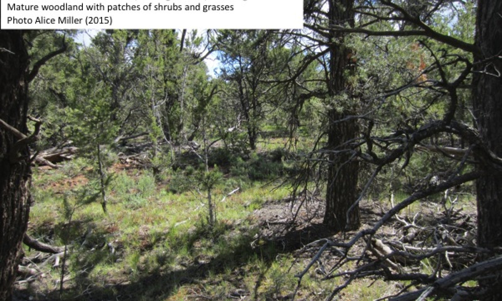
Twoneedle pinyon – Utah juniper/ mountain big sagebrush / muttongrass woodla
Figure 7. Community Phase 2.1
This community phase is characterized by 15 to 40% canopy cover of short-statured up to 30’ tall twoneedle pinyon and Utah juniper and, with twoneedle pinyon generally dominant, and multiple age structures of both species. Ponderosa pine (Pinus ponderosa) may be a minor tree. The shrub canopy ranges from 5 to 20%, and is distributed patchily, with higher cover in canopy gaps. Mountain big sagebrush and Gambel’s oak are typically present. Snowberry (Symphoricarpos oreophilus) may be locally abundant. Common secondary shrubs include antelope bitterbrush (Purshia tridentata), black sagebrush (Artemisia nova), Utah serviceberry (Amelanchier utahensis), broom snakeweed (Gutierrezia sarothrae), plains pricklypear (Opuntia polyacantha), and Whipple cholla (Cylindropuntia whipplei). , and over 6 to 20% shrub canopy, with Wyoming big sagebrush the dominant shrub. A productive perennial grass layer is present with cover ranging from 5 to 13%, and is dominated by muttongrass. Secondary grasses may include squirreltail (Elymus elymoides), Indian ricegrass (Achnatherum hymenoides), saline wildrye (Leymus salinus), Sandberg bluegrass (Poa secunda), sedge (Carex spp), and sand dropseed (Sporabolis cryptandrus). Sand dropseed is not naturally present in this forest type, but was and is commonly seeded into chaining treatments (Redmond et al. 2014). Forbs contribute 1 to 3% cover, and rock goldenrod and dwarf lousewort are the most abundant species. Other forb species recorded in data plots include hollyleaf clover (Trifolium gymnocarpon), straight bladderpod (Physaria rectipes), rabbit ear rockcress (Arabis pendulina), spreading fleabane (Erigeron divergens), redroot buckwheat (Arabis racemosum), and milkvetch (Astragalus spp). Total foliar canopy cover averages 34%. The soil surface is dominated by litter at 18-26% cover, with 2-7% coarse woody debris, 2 to 10% BSC, 0-3% gravel, and 7-16% bare ground.
Figure 8. Annual production by plant type (representative values) or group (midpoint values)
Table 5. Annual production by plant type
Plant type Low
(lb/acre)Representative value
(lb/acre)High
(lb/acre)Tree 2500 3500 4600 Grass/Grasslike 50 160 260 Shrub/Vine 40 55 150 Forb 10 20 120 Total 2600 3735 5130 Table 6. Ground cover
Tree foliar cover 20-40% Shrub/vine/liana foliar cover 10-20% Grass/grasslike foliar cover 10-10% Forb foliar cover 0-0% Non-vascular plants 0-10% Biological crusts 0-10% Litter 20-30% Surface fragments >0.25" and <=3" 0-0% Surface fragments >3" 0% Bedrock 0% Water 0% Bare ground 10-20% Table 7. Canopy structure (% cover)
Height Above Ground (ft) Tree Shrub/Vine Grass/
GrasslikeForb <0.5 0-1% 0-2% 7-13% 0-3% >0.5 <= 1 0-1% 0-5% 0-2% – >1 <= 2 0-1% 0-5% – – >2 <= 4.5 0-4% 0-9% – – >4.5 <= 13 1-12% – – – >13 <= 40 14-37% – – – >40 <= 80 – – – – >80 <= 120 – – – – >120 – – – – Community 2.2
Fire recovery grassland
Figure 9. Community Phase 2.2
Community composition data were not collected for this community phase, but it was observed in the field. The composition description is based on field observations and literature review. This phase is characterized by herbaceous dominance, and may last for 11 to 25 plus years (Erdman 1970, West 1979). The first 2-3 years post-fire are likely to be dominated by annual species such as desert goosefoot (Chenopodium pratericola) and common sunflower (Helianthus annus) (Erdman 1970). Cheatgrass may become abundant. Crown-sprouting shrubs such as Gambel’s oak, mountain snowberry, Utah serviceberry, and banana yucca will likely sprout during the first year after fire, but are will be a minor component of the vegetation community. Perennial grasses become dominant 3-4 years after fire, with muttongrass and squirreltail likely to be dominant. Other grasses may include Indian ricerass, saline wildrye, and blue grama. Perennial forbs including rock goldenrod, spreading fleabane, and redroot buckwheat will become established by 4 years after fire.
Community 2.3
Mountain big sagebrush – Gambel’s oak mixed shrubland
Figure 10. Community Phase 2.3
Data were not collected for this community phase, and composition is based on literature review. This phase is characterized by shrub dominance, with scattered regenerating trees (Erdman 1970, West 1979, Floyd et al. 2000, Floyd et al. 2004). Gambel’s oak is often dominant, and other resprouters such as mountain snowberry and Utah serviceberry may be important species. Mountain big sagebrush and black sagebrush may have become re-established. Antelope bitterbrush, mormon tea, broom snakeweed, banana yucca, and plains pricklypear are likely to be secondary shrubs. Herbaceous species remain abundant in this phase, with muttongrass and squirreltail likely dominant. Twoneedle pinyon and Utah juniper become established during this phase.
Community 2.4
Twoneedle pinyon – Utah juniper woodland
Figure 11. Community Phase 2.4
This community phase is characterized by reductions in understory cover and strong tree dominance. Tree cover averages 42%, shrub cover may be up to 15%, and grass and forb cover are trace. This phase may occur naturally with canopy closure, or be accelerated due to improper livestock grazing that reduces understory cover and reduces competition for trees, resulting in increased tree recruitment (e.g. Harris et al. 2003, Landis and Bailey 2005, Shinneman and Baker 2009). Where this phase has developed naturally without excessive grazing, biological soil crust cover ranges from 15-20%, moss/lichen 1-2%, litter cover 10-12%, woody debris 1-3%, and bare ground 20-30%.
Figure 12. Annual production by plant type (representative values) or group (midpoint values)
Table 8. Annual production by plant type
Plant type Low
(lb/acre)Representative value
(lb/acre)High
(lb/acre)Tree 2000 3000 4600 Shrub/Vine 0 10 50 Forb 0 0 6 Grass/Grasslike 0 0 2 Total 2000 3010 4658 Table 9. Ground cover
Tree foliar cover 30-50% Shrub/vine/liana foliar cover 0-20% Grass/grasslike foliar cover 0-0% Forb foliar cover 0-0% Non-vascular plants 0-0% Biological crusts 20-20% Litter 10-20% Surface fragments >0.25" and <=3" 0% Surface fragments >3" 0% Bedrock 0% Water 0% Bare ground 20-30% Table 10. Canopy structure (% cover)
Height Above Ground (ft) Tree Shrub/Vine Grass/
GrasslikeForb <0.5 – – 0-1% 0-2% >0.5 <= 1 – – 0-1% 0-2% >1 <= 2 – – – – >2 <= 4.5 – 0-5% – – >4.5 <= 13 3-9% 0-15% – – >13 <= 40 30-50% – – – >40 <= 80 – – – – >80 <= 120 – – – – >120 – – – – Community 2.5
Twoneedle pinyon – Utah juniper / high grass understory woodlandThis community phase develops with chaining or other near removal of the tree and shrub component, followed by seeding. The seeding mix is typically a mix of native and non-native perennial grasses, and may be composed of crested wheatgrass (Agropyron cristatum), western wheatgrass (Pascopyrum smithii ), blue grama, squirreltail, Sandberg bluegrass, prairie junegrass (Koeleria macrantha), and sand dropseed. The non-native crested wheatgrass was abundant in seed mixes in the 1970s, and was often the most abundant species following thinning and seeding, and can remain an important species for at least 40 years (Redmond et al. 2013). Tree cover is much reduced in this community phase, with cover at less than 2 to 7%. Invasive species may increase, with cheatgrass commonly found, and Russian thistle, tumble mustard, and prickly lettuce (Lactuca serriola) all potentially increasing in this phase (Redmond et al. 2014).
The following tables are based on NRCS data collection following chaining and seeding treatments in this ecological site in 1977.
Figure 13. Annual production by plant type (representative values) or group (midpoint values)
Table 11. Annual production by plant type
Plant type Low
(lb/acre)Representative value
(lb/acre)High
(lb/acre)Grass/Grasslike 120 260 400 Tree 200 250 300 Forb 20 50 80 Shrub/Vine 50 60 70 Total 390 620 850 Table 12. Ground cover
Tree foliar cover 0-10% Shrub/vine/liana foliar cover 10-10% Grass/grasslike foliar cover 10-30% Forb foliar cover 0-10% Non-vascular plants 0% Biological crusts 0% Litter 20-30% Surface fragments >0.25" and <=3" 0-20% Surface fragments >3" 0% Bedrock 0% Water 0% Bare ground 40-40% Pathway 2.1a
Community 2.1 to 2.2
Twoneedle pinyon – Utah juniper/ mountain big sagebrush / muttongrass woodla
Fire recovery grasslandThis pathway occurs with infrequent, stand-clearing fire.
Pathway 2.1c
Community 2.1 to 2.3
Twoneedle pinyon – Utah juniper/ mountain big sagebrush / muttongrass woodla
Mountain big sagebrush – Gambel’s oak mixed shrublandThis pathway may occur with forest management that removes the tree component.
Pathway 2.1b
Community 2.1 to 2.4
Twoneedle pinyon – Utah juniper/ mountain big sagebrush / muttongrass woodla
Twoneedle pinyon – Utah juniper woodlandThis pathway may occur with canopy closure in a mature forest that shades out understory species. Improper livestock use that removes understory vegetation and reduces competition with tree seedlings may also lead to this community phase.
Pathway 2.1d
Community 2.1 to 2.5This pathway occurs with chaining, or other management practice that removes the bulk of tree and woody vegetation, followed by perennial grass seeding.
Pathway 2.2a
Community 2.2 to 2.3
Fire recovery grassland
Mountain big sagebrush – Gambel’s oak mixed shrublandThis pathway occurs with time without additional disturbance. It will take approximately 11-25 plus years, with recovery time dependent on fire severity, precipitation amount and timing, and the availability of off-site seed for dispersal.
Pathway 2.3a
Community 2.3 to 2.1
Mountain big sagebrush – Gambel’s oak mixed shrubland
Twoneedle pinyon – Utah juniper/ mountain big sagebrush / muttongrass woodlaThis pathway occurs with time and a lack of additional disturbance. Forty to 100 years may be required before canopy trees are a dominant aspect of the community (e.g. West 1979, Shinneman and Baker 2009, Romme et al. 2009), and 2500 or more years may be required before trees are dominant and woodland structure returns (Erdman 1970, West 1979, Floyd et al. 2004).
Pathway 2.3b
Community 2.3 to 2.2
Mountain big sagebrush – Gambel’s oak mixed shrubland
Fire recovery grasslandThis pathway occurs with fire. Recurrent fire can maintain a shrubland state (e.g. Erdman 1970, Floyd et al. 2000).
Pathway 2.4b
Community 2.4 to 2.1
Twoneedle pinyon – Utah juniper woodland
Twoneedle pinyon – Utah juniper/ mountain big sagebrush / muttongrass woodlaThis pathway may occur with forest management that thins the tree canopy and provides openings for understory recruitment. Seeding may increase and/or hasten understory recovery.
Pathway 2.4a
Community 2.4 to 2.2
Twoneedle pinyon – Utah juniper woodland
Fire recovery grasslandThis pathway occurs with fire.
Pathway 2.5a
Community 2.5 to 2.2This pathway occurs with fire.
Transition T1A
State 1 to 2Transition from reference state (State 1) to current potential state (State 2). This transition may occur with improper livestock grazing and introduction of invasive species.
Additional community tables
Table 13. Community 1.1 plant community composition
Group Common name Symbol Scientific name Annual production () Foliar cover (%) Tree1 Trees 2500–4600 twoneedle pinyon PIED Pinus edulis 1755–3485 7–35 Utah juniper JUOS Juniperus osteosperma 0–2015 0–10 Shrub/Vine2 Shrubs 40–150 Gambel oak QUGA Quercus gambelii 0–180 0–15 mountain snowberry SYOR2 Symphoricarpos oreophilus 0–125 0–15 mountain big sagebrush ARTRV Artemisia tridentata ssp. vaseyana 15–60 1–10 antelope bitterbrush PUTR2 Purshia tridentata 0–60 0–6 Shrub, other 2S Shrub, other 0–60 0–3 black sagebrush ARNO4 Artemisia nova 0–20 0–5 Whipple cholla CYWH Cylindropuntia whipplei 0–5 0–1 broom snakeweed GUSA2 Gutierrezia sarothrae 0–5 0–1 tulip pricklypear OPPH Opuntia phaeacantha 0–5 0–1 Utah serviceberry AMUT Amelanchier utahensis 0–5 0–1 Grass/Grasslike3 Perennial Grasses 255–550 muttongrass POFE Poa fendleriana 200–330 4–10 Indian ricegrass ACHY Achnatherum hymenoides 50–85 1–4 sedge CAREX Carex 0–60 0–3 saline wildrye LESA4 Leymus salinus 4–55 1–3 Grass, perennial 2GP Grass, perennial 0–50 0–3 Sandberg bluegrass POSE Poa secunda 0–15 0–1 squirreltail ELEL5 Elymus elymoides 0–5 0–1 Forb4 Forbs 10–35 rock goldenrod PEPU7 Petradoria pumila 2–120 1–5 dwarf lousewort PECE Pedicularis centranthera 0–15 0–2 Forb, annual 2FA Forb, annual 0–10 0–2 Forb, perennial 2FP Forb, perennial 0–10 0–2 rabbit ear rockcress ARPE Arabis pendulina 0–5 0–1 hollyleaf clover TRGY Trifolium gymnocarpon 0–2 0–1 straight bladderpod PHRE9 Physaria rectipes 0–2 0–1 milkvetch ASTRA Astragalus 0–2 0–1 spreading fleabane ERDI4 Erigeron divergens 0–2 0–1 redroot buckwheat ERRA3 Eriogonum racemosum 0–2 0–1 Table 14. Community 2.1 plant community composition
Group Common name Symbol Scientific name Annual production () Foliar cover (%) Tree1 Trees 2500–4600 twoneedle pinyon PIED Pinus edulis 1755–3485 7–35 Utah juniper JUOS Juniperus osteosperma 0–2015 0–10 ponderosa pine PIPO Pinus ponderosa 0–85 0–1 Shrub/Vine2 Shrubs 40–160 Gambel oak QUGA Quercus gambelii 0–180 0–15 mountain snowberry SYOR2 Symphoricarpos oreophilus 0–125 0–15 Shrub, other 2S Shrub, other 0–60 0–10 mountain big sagebrush ARTRV Artemisia tridentata ssp. vaseyana 15–60 1–10 antelope bitterbrush PUTR2 Purshia tridentata 0–60 0–6 Utah serviceberry AMUT Amelanchier utahensis 0–25 0–2 broom snakeweed GUSA2 Gutierrezia sarothrae 0–25 0–1 black sagebrush ARNO4 Artemisia nova 0–20 0–5 Whipple cholla CYWH Cylindropuntia whipplei 0–6 0–1 tulip pricklypear OPPH Opuntia phaeacantha 0–5 0–1 Grass/Grasslike3 Grasses 50–260 muttongrass POFE Poa fendleriana 30–205 4–10 sedge CAREX Carex 0–60 0–3 saline wildrye LESA4 Leymus salinus 5–55 1–3 Grass, perennial 2GP Grass, perennial 0–50 0–3 sand dropseed SPCR Sporobolus cryptandrus 9–50 0–3 Indian ricegrass ACHY Achnatherum hymenoides 0–20 0–2 Sandberg bluegrass POSE Poa secunda 0–15 0–2 squirreltail ELEL5 Elymus elymoides 0–5 0–1 Forb4 Forbs 10–120 rock goldenrod PEPU7 Petradoria pumila 2–120 1–5 dwarf lousewort PECE Pedicularis centranthera 0–15 0–2 Forb, annual 2FA Forb, annual 0–10 0–2 Forb, perennial 2FP Forb, perennial 0–10 0–2 rabbit ear rockcress ARPE Arabis pendulina 0–5 0–1 hollyleaf clover TRGY Trifolium gymnocarpon 0–2 0–1 straight bladderpod PHRE9 Physaria rectipes 0–2 0–1 milkvetch ASTRA Astragalus 0–2 0–1 spreading fleabane ERDI4 Erigeron divergens 0–2 0–1 redroot buckwheat ERRA3 Eriogonum racemosum 0–2 0–1 Table 15. Community 2.2 plant community composition
Group Common name Symbol Scientific name Annual production () Foliar cover (%) Table 16. Community 2.3 plant community composition
Group Common name Symbol Scientific name Annual production () Foliar cover (%) Table 17. Community 2.4 plant community composition
Group Common name Symbol Scientific name Annual production () Foliar cover (%) Tree1 Trees 2000–4600 twoneedle pinyon PIED Pinus edulis 1600–2400 21–35 Utah juniper JUOS Juniperus osteosperma 305–450 5–13 Shrub/Vine2 Shrubs 0–60 Gambel oak QUGA Quercus gambelii 0–50 0–10 mountain big sagebrush ARTRV Artemisia tridentata ssp. vaseyana 0–15 0–5 mormon tea EPVI Ephedra viridis 0–5 0–1 broom snakeweed GUSA2 Gutierrezia sarothrae 0–5 0–1 tulip pricklypear OPPH Opuntia phaeacantha 0–5 0–1 antelope bitterbrush PUTR2 Purshia tridentata 0–5 0–1 narrowleaf yucca YUAN2 Yucca angustissima 0–5 0–1 Utah serviceberry AMUT Amelanchier utahensis 0–5 0–1 Grass/Grasslike3 Grasses 0–2 Indian ricegrass ACHY Achnatherum hymenoides 0–2 0–1 blue grama BOGR2 Bouteloua gracilis 0–2 0–1 Forb4 Forbs 0–6 rabbit ear rockcress ARPE Arabis pendulina 0–2 0–1 arrowleaf balsamroot BASA3 Balsamorhiza sagittata 0–2 0–1 tiny trumpet COLI2 Collomia linearis 0–2 0–1 Carolina draba DRRE2 Draba reptans 0–2 0–1 rock goldenrod PEPU7 Petradoria pumila 0–2 0–1 Table 18. Community 2.5 plant community composition
Group Common name Symbol Scientific name Annual production () Foliar cover (%) Tree1 Trees 200–300 twoneedle pinyon PIED Pinus edulis 100–160 1–3 Utah juniper JUOS Juniperus osteosperma 50–100 1–2 Shrub/Vine2 Shrubs 50–70 mountain big sagebrush ARTRV Artemisia tridentata ssp. vaseyana 0–30 0–2 broom snakeweed GUSA2 Gutierrezia sarothrae 0–25 0–2 mormon tea EPVI Ephedra viridis 0–25 0–1 rubber rabbitbrush ERNA10 Ericameria nauseosa 0–20 0–2 antelope bitterbrush PUTR2 Purshia tridentata 0–20 0–1 Mexican cliffrose PUME Purshia mexicana 0–15 0–1 snowberry SYMPH Symphoricarpos 0–2 0–1 Grass/Grasslike3 Native Grasses 10–160 Indian ricegrass ACHY Achnatherum hymenoides 1–40 1–3 squirreltail ELEL5 Elymus elymoides 0–40 0–3 Junegrass KOELE Koeleria 0–30 0–2 James' galleta PLJA Pleuraphis jamesii 0–20 0–2 purple threeawn ARPU9 Aristida purpurea 0–20 0–2 blue grama BOGR2 Bouteloua gracilis 0–8 0–2 5 Non-native Grasses 8–360 crested wheatgrass AGCR Agropyron cristatum 0–320 0–15 cheatgrass BRTE Bromus tectorum 8–40 1–10 Forb4 Native Forbs 10–45 rubberweed HYMEN7 Hymenoxys 10–40 1–3 Forb, perennial 2FP Forb, perennial 0–10 0–1 phlox PHLOX Phlox 0–5 0–1 globemallow SPHAE Sphaeralcea 0–5 0–1 6 Non-native Forbs 0–35 Russian thistle SALSO Salsola 0–35 0–2 Interpretations
Animal community
--Livestock and Wildlife Grazing--
This site provides good grazing conditions for livestock and wildlife during spring, summer, and fall when in good ecological condition due to accessibility and available nutritious forage. This site often lacks natural perennial water sources, which can influence the suitability for livestock and wildlife grazing. Care should be taken to maintain the native perennial grasses and shrubs due to the poor suitability for re-seeding or restoring this site. Reseeding and/or restoration are difficult due to the extreme temperatures and variability in time and amount of precipitation. This site may occur in mule deer habitat; however in many places the populations will be small and have little grazing impact on the site.
The plant community is generally equal mixtures of grasses, shrubs, and trees. Grasses include muttongrass, Indian ricegrass, blue grama, galleta, and purple threeawn and provide good grazing conditions for cattle, horses, and sheep. Shrubs include mountain big sagebrush and green mormontea. These shrubs provide good browse for cattle, sheep, goats, and mule deer. Utah juniper and pinyon pine provide good cover for livestock and wildlife; mule deer and goats may also graze these trees. Forb composition and annual production depends primarily on precipitation amounts and thus is challenging to use in livestock grazing management decisions. However, forb composition should be monitored for species diversity, as well as poisonous or injurious plant communities which may be detrimental to livestock if grazed. Before making specific grazing management recommendations, an onsite evaluation must be made.
Hydrological functions
The hydrologic group is D.
Recreational uses
Recreational uses of this site are hiking, picnicking, and hunting.
Wood products
Potential wood products are fuel and posts.
Other information
--Poisonous/Toxic Plant Communities--
Toxic plants associated with this site include freckled milkvetch/spotted locoweed and broom snakeweed. Milkvetch/locoweed is toxic to all classes of livestock and wildlife. This plant is palatable and has similar nutrient value to alfalfa, which may cause animals to consume it even when other forage is available. Milkvetch/locoweed contains swainsonine (indolizdine alkaloid) and is poisonous at all stages of growth. Poisoning will become evident after 2-3 weeks of continuous grazing and is associated with 4 major symptoms: 1) neurological damage, 2) emaciation, 3) reproductive failure and abortion, and 4) congestive heart failure linked with “high mountain disease”. Broom snakeweed contains steroids, terpenoids, saponins, and flavones that can cause abortions or reproductive failure in sheep and cattle, however cattle are most susceptible. These toxins are most abundant during active growth and leafing stage. Cattle and sheep will generally only graze broom snakeweed when other forage is unavailable, typically in winter when toxicity levels are at their lowest.
Potentially toxic plants associated with this site include some buckwheat species. Some buckwheat species may accumulate selenium, but only when growing on selenium enriched soils. These plants, when consumed will cause alkali disease or chronic selenosis, which affects all classes of livestock (excluding goats). Typically animals consuming 5-50 ppm selenium will develop chronic selenosis and animals consuming greater than 50 ppm selenium will develop acute selenosis. Clinical signs include lameness, soughing of the hoof, hair loss, blindness, and aimless wondering. Horses tend to develop what is called a “bob” tail or “roached” main due to breakage of the long hairs.
Russian thistle is an invasive toxic plant, causing nitrate and to a lesser extent oxalate poisoning, which affects all classes of livestock. The buildup of nitrates in these plants is highly dependent upon environmental factors, such as after a rain storm during a drought, cool/cloudy days, and soils high in nitrogen and low in sulfur and phosphorus, all which cause increased nitrate accumulation. Nitrate collects in the stems and can persist throughout the growing season. Clinical signs of nitrate poisoning include drowsiness, weakness, muscular tremors, increased heart and respiratory rates, staggering gait, and death. Conversely, oxalate poisoning causes kidney failure; clinical signs include muscle tremors, tetany, weakness, and depression. Poisoning generally occurs when livestock consume and are not accustomed to grazing oxalate-containing plants. Animals with prior exposure to oxalates have increased numbers of oxalate-degrading rumen microflora and thus are able to degrade the toxin before clinical poisoning can occur.
--Invasive Plant Communities--
Generally as ecological conditions deteriorate and perennial vegetation decreases due to disturbance (fire, over grazing, drought, off road vehicle overuse, erosion, etc.) annual forbs and grasses will invade the site. Of particular concern in semi-arid environments are the non-native annual invaders including cheatgrass, Russian thistle, prickly lettuce, and annual mustards. The presence of these species will depend on soil properties and moisture availability; however, these invaders are highly adaptive and can flourish in many locations. Once established, complete removal is difficult but suppression may be possible. On well developed Utah juniper and pinyon pine communities soils are complete occupied by lateral roots, which inhibit an herbaceous understory as well as annual invasions. However once these sites are disturbed and pinyon-juniper communities begin to decline invasion is possible.
Supporting information
Inventory data references
High intensity sampling (Caudle et al. 2013) was used to describe this ecological site (Community Phase 2.1). Site characteristics such as aspect, slope, elevation and UTMS were recorded for each plot, along with complete species inventory by ocular percent cover. The line-point intercept method was used to measure foliar cover, groundcover, and vegetation structure. At 100 points along a 200 foot transect, ground cover and intercepted plant species were recorded by height. The first hit method (Herrick et al. 2009) was used to generate the foliar cover values entered in the community phase composition tables. Annual production was estimated using the double-weight sampling method outlined in the National Range and Pasture Handbook and in Sampling Vegetation Attributes (NRCS 2003 and Interagency Technical Reference 1999 pgs. 102 - 115). For herbaceous vegetation, ten 9.6 square foot circular sub-plots were evenly distributed along a 200 foot transect. For woody and larger herbaceous species, production was estimated in four 21x21 foot square plots along the same transect. Weight units were collected for each species encountered in the production plots. The number of weight units for each species is then estimated for all plots. NRCS Range Inventory plots from the 1970s were used to describe Community Phase 2.5, and were also used in the description of Community Phase 2.1 and 2.4.
Type locality
Location 1: San Juan County, UT UTM zone N UTM northing 4239458 UTM easting 666705 General legal description The type location occurs on Wray Mesa, approximately Highway 91 (Moab) to Highway 46 South on 163(Wray Mesa Road), south on unnamed road Other references
Belnap, J. and D. Eldridge. 2003. Disturbance and recovery of biological soil crusts. Pages 363-383 Biological soil crusts: structure, function, and management. Springer, Berlin Heidelberg.
Caudle, D., H. Sanchez, J. DiBenedetto, C. Talbot, and M. Karl. 2013. Interagency ecological site handbook for rangelands. USDA-NRCS, USDA-FS, DOI-BLM.
Cole, K. L., N. Henderson, and D. S. Shafer. 1997. Holocene vegetation and historic grazing impacts at Capitol Reef National Park reconstructed using packrat middens. Great Basin Naturalist 57:315-326.
Ehleringer, J. E., S. Schwinning, and R. Gebauer. 2000. Water use in arid land ecosystems. Pages 347-365. Blackwell Science, University of York.
Erdman, J. A. 1970. Pinyon-junipe succession after natural fires on residual soils of Mesa Verde, Colorado. Brigham Young University Science Bulletin: Biological Series 11:1-26.
Evans, R. D. and J. Belnap. 1999. Long-term consequences of disturbance on Nitrogen dynamics in an arid ecosystem. Ecology 80:150-160.
Floyd, M. L., D. D. Hanna, and W. H. Romme. 2004. Historical and recent fire regimes in pinon-juniper woodlands on Mesa Verde, Colorado, USA. Forest Ecology and Management 198:269-289.
Floyd, M. L., W. H. Romme, and D. D. Hanna. 2000. Fire history and vegetation patterns in Mesa Verde National Park, Colorado, USA. Ecological Applications 106:1666-1680.
Floyd, M. L., W. H. Romme, D. D. Hanna, M. Winterowd, D. Hanna, and J. Spence. 2008. Fire history of pinon-juniper woodlands on Navajo Point, Glen Canyon National Recreation Area. Natural Areas Journal 28:26-36.
Harris, A. T., G. P. Asner, and M. E. Miller. 2003. Changes in vegetation structure after long-term grazing in pinyon-juniper ecosystems: integrating imaging spectroscopy and field studies. Ecosystems 6:368-383.
Hereford, R., R. H. Webb, and S. Graham. 2002. Precipitation history of the Colorado Plateau Region, 1900-2000. U.S. Geological Survey Fact Sheet 119-02. (online). U. S. Geological Survey.
Herrick, J. E., J. W. V. Zee, K. M. Havstad, L. M. Burkett, and W. G. Whitford. 2009. Monitoring manual for grassland, shrubland, and savanna ecosystems. Volume I: Quick Start. USDA-ARS Jornada Experimental Range, Tucson, AZ.
Landis, A. G. and J. D. Bailey. 2005. Reconstruction of age structure and spatial arrangement of pinon-juniper woodlands and savannas of Anderson Mesa, northern Arizona. Forest Ecology and Management 204:221-236.
Mack, R. N. and J. N. Thompson. 1982. Evolution in steppe with few large, hooved mammals. The American Naturalist 119:757-773.
Miller, M. E. 2004. The structure and functioning of dryland ecosystems - conceptual models to inform the vital-sign selection process. United States Geological Survey Report, February draft Report, Moab, UT.
NatureServe. 2015. NatureServe Explorer: An online encyclopedia of life [web application]. Version 7.1. NatureServe, Arlington, Virginia. Available http://explorer.natureserve.org. (Accessed: December 7, 2015 ).
Niebergall, J. 1993. Vegetation changes on the Manti-La Sal National Forest. A photographic study ysing comparative photographs from 1902-1992. U.S. Department of Agriculture, Forest Service, La Sal National Forest, Price, Utah.
Pickford, G. D. 1932. The influence of continued heavy grazing and of promiscuous burning on spring-fall ranges in Utah. Ecology 13:159-171.
Redmond, M. D., N. S. Cobb, M. E. Miller, and N. N. Barger. 2013. Long-term effects of chaining treatments on vegetation structure in pinon-juniper woodlands of the Colorado Plateau. Forest Ecology and Management 305:120-128.
Redmond, M. D., F. Forcella, and N. N. Barger. 2012. Declines in pinyon pine cone production associated with regional warming. Ecosphere 3.
Redmond, M. D., T. J. Zelikova, and N. N. Barger. 2014. Limits to understory plant restoration following fuel-reduction treatments in a pinon-juniper woodland. Environmental Management 54:1139-1152.
Romme, W. H., C. D. Allen, J. D. Bailey, W. L. Baker, B. T. Bestelmeyer, P. M. Brown, K. S. Eisenhart, M. L. Floyd, D. W. Huffman, B. F. Jacobs, R. F. Miller, E. H. Muldavin, T. W. Swetnam, R. J. Tausch, and P. J. Weisberg. 2009. Historical and modern disturance regimes, stand structures, and landscape dynamics in pinon-juniper vegetation of the Western United States. Rangeland Ecology and Management 62:203-222.
Schwinning, S., J. Belnap, D. R. Bowling, and J. R. Ehleringer. 2008. Sensitivity of the Colorado Plateau to change: climate, ecoystems, and society. Ecology and Society 13:28.
Shinneman, D. J. and W. L. Baker. 2009. Historical fire and multidecadal drought as context for pinon-juniper woodland restoration in western Colorado. Ecological Applications 19:1231-1245.
Spence, J. R. 2001. Climate of the central Colorado Plateau, Utah and Arizona: Characterization and recent trends. Pages 187-203 in C. van Riper III, K. A. Thomas, and M. A. Stuart, editors. Proceedings of the fifth biennial conference of research on the Colorado Plateau. U.S. Geological Survey/FRESC Report Series USGSFRESC/COPL/2001/24.
Tuhey, J. S. and J. A. MacMahon. 1988. Vegetation and relict communities of Glen Canyon National Recreation Area. US Department of the Interior, National Park Service, Rocky Mountain Regional Office.
West, G. J. 1979. Recent palynology of the Cedar Mesa Area, Utah. University of California, Davis.
Contributors
Alice Miller
Rangeland health reference sheet
Interpreting Indicators of Rangeland Health is a qualitative assessment protocol used to determine ecosystem condition based on benchmark characteristics described in the Reference Sheet. A suite of 17 (or more) indicators are typically considered in an assessment. The ecological site(s) representative of an assessment location must be known prior to applying the protocol and must be verified based on soils and climate. Current plant community cannot be used to identify the ecological site.
Author(s)/participant(s) Alice Miller (Pyramid Botanical Consultants), Shane A. Green (NRCS) Contact for lead author shane.green@ut.usda.gov Date 02/26/2016 Approved by Approval date Composition (Indicators 10 and 12) based on Annual Production Indicators
-
Number and extent of rills:
Few to many, occur throughout site, and are more frequent on steeper slopes (> 10%). Rills may be 5 to 15 feet in length. Sides of rills may be up to 3 inches high. An increase in rill formation may be seen after disturbance events such as recent fire or thunderstorms in adjacent landscape settings where increased runoff may accumulate (such as areas below exposed bedrock). -
Presence of water flow patterns:
Frequent and occur throughout area. Interspaces between well developed biological soil crusts appear to be water depression storage areas but actually serve as water flow patterns across areas covered with biological soil crust during episodic precipitation events. -
Number and height of erosional pedestals or terracettes:
Pedestals form at the base of plants that occur on the edge of rills. Interspaces between well developed biological soil crusts resemble pedestals and may be up to 2 inches high. Terracettes are present. Some debris dams of small to medium sized litter (up to 2 inches in diameter) may form in water flow patterns, rills, and gullies. These debris dams may accumulate smaller litter (leaves, grass and forb stems). -
Bare ground from Ecological Site Description or other studies (rock, litter, lichen, moss, plant canopy are not bare ground):
7 – 16 %. Most bare ground is associated with water flow patterns, rills, and gullies. Biological soil crust expression is variable on this site, with 2 to 10% cover. Areas with well developed biological soil crusts should not be counted as bare ground. Poorly developed biological soil crusts that are interpreted as functioning as bare ground (therefore they would be susceptible to raindrop splash erosion) should be recorded as bare ground. Ground cover is based on first raindrop impact, and bare ground is the opposite of ground cover. Ground cover + bare ground = 100%. -
Number of gullies and erosion associated with gullies:
Typically few. On steeper slopes and areas below and adjacent to sites with concentrated water flow (such as slope breaks and exposed bedrock), gullies may increase. Gullies are shallow. Gullies may remove soil from the base of trees exposing roots. Any gullies present should show little sign of accelerated erosion. -
Extent of wind scoured, blowouts and/or depositional areas:
None to very few. High tree cover on this site breaks the wind and reduces the potential for wind erosion. -
Amount of litter movement (describe size and distance expected to travel):
Most litter accumulates at base of plants. Woody stems are not moved unless present in water flow pattern, rill, or gully. Gullies may remove accumulated litter from under trees and shrubs. -
Soil surface (top few mm) resistance to erosion (stability values are averages - most sites will show a range of values):
This site should have a soil stability rating of 4 to 6. Vegetation cover, litter, and biological soil crusts reduce erosion. -
Soil surface structure and SOM content (include type of structure and A-horizon color and thickness):
Soil surface varies from typically 3 inches. Color is brown (7.5YR 5/4). Structure is weak fine granular. Refer to the specific information for the soil you are assessing found in the published soil survey to supplement this description. -
Effect of community phase composition (relative proportion of different functional groups) and spatial distribution on infiltration and runoff:
Spatial distribution of vegetation, litter, and soil biological crusts (where present) intercept raindrops, reduce splash erosion and provide areas of surface detention to store water allowing additional time for infiltration. Crowns of trees and accumulating litter at base of trees appear to create a micro-topography that may enhance development of water flow patterns below the drip line of the canopy. -
Presence and thickness of compaction layer (usually none; describe soil profile features which may be mistaken for compaction on this site):
A 5-12 inch thick hardpan is present at 7-13 inches below the soil surface, overlying sandstone bedrock. -
Functional/Structural Groups (list in order of descending dominance by above-ground annual-production or live foliar cover using symbols: >>, >, = to indicate much greater than, greater than, and equal to):
Dominant:
Trees (pinyon >> juniper) >> perennial grasses > shrubs > forbsSub-dominant:
Other:
Additional:
-
Amount of plant mortality and decadence (include which functional groups are expected to show mortality or decadence):
Several standing dead trees may be present on the site and approximately 30% of trees and shrubs can show evidence of decadence, although shrub decadence may be higher in sites in a late seral expression. During drought tree mortality may increase with the first sign being a yellowish to reddish leaf color. -
Average percent litter cover (%) and depth ( in):
Course woody debris (10-1000 hour fuels) are 2-7% of the litter cover. -
Expected annual annual-production (this is TOTAL above-ground annual-production, not just forage annual-production):
2600 - 5130 pounds/acre. -
Potential invasive (including noxious) species (native and non-native). List species which BOTH characterize degraded states and have the potential to become a dominant or co-dominant species on the ecological site if their future establishment and growth is not actively controlled by management interventions. Species that become dominant for only one to several years (e.g., short-term response to drought or wildfire) are not invasive plants. Note that unlike other indicators, we are describing what is NOT expected in the reference state for the ecological site:
Cheatgrass (Bromus tectorum) and annual forbs including russian thistle (Salsola spp.), prickly lettuce (Lactuca serriola), and tumble mustard (Sisymbrium spp.) are likely to invade this site. -
Perennial plant reproductive capability:
All perennial plants should have the ability to reproduce sexually or asexually in most years, except in drought years.
Print Options
Sections
Font
AAAAOther
PrintThe Ecosystem Dynamics Interpretive Tool is an information system framework developed by the USDA-ARS Jornada Experimental Range, USDA Natural Resources Conservation Service, and New Mexico State University.
Accessibility statement