Natural Resources
Conservation Service
Ecological site R035XY248UT
Semidesert Very Shallow Sandy Loam (Blackbrush)
Accessed: 07/12/2026
-
Search


Major Land Resource Area or ecological site by name and/or ID.
PreviousSectionsNextGeneral information
Draft. A draft ecological site description is either incomplete or has not undergone quality control and quality assurance review.
MLRA notes
Major Land Resource Area (MLRA): 035X–Colorado Plateau
This ecological site occurs in the north western portion of MLRA 35, Colorado Plateau Province. It is found principally in the High Plateaus of Utah section within that MLRA. This area has been stucturally uplifted over time while rivers flowing across it were cutting down into its bedrock. Areas of shale, sandstone, limestone, dolomite, and volcanic rock outcrop are found throughout the region.
Associated sites
R035XY018UT Talus Slope (Blackbrush-Shadscale)
R035XY243UT Semidesert Stony Loam (Blackbrush)
R035XY246UT Semidesert Stony Loam (Utah Juniper-Pinyon)
Similar sites
R035XY243UT Semidesert Stony Loam (Blackbrush)
Table 1. Dominant plant species
Tree Not specified
Shrub (1) Coleogyne ramosissima
(2) Atriplex confertifoliaHerbaceous (1) Pleuraphis jamesii
Physiographic features
This site is found principally on hillslopes and structural benches. Runoff is high. Slopes typically range from 4-30%. Elevations are generally 5500-5600.
Table 2. Representative physiographic features
Landforms (1) Hill
(2) Structural bench
Flooding frequency None Ponding frequency None Elevation 5500 – 5600 ft Slope 4 – 30 % Water table depth 0 in Aspect Aspect is not a significant factor Climatic features
The climate is characterized by hot summers and cool to warm winters. Large fluctuations in daily temperatures are common. Mean annual high temperature is approximately 50 degrees Fahrenheit and mean annual low temperature is 47 degrees Fahrenheit. Approximately 75 percent of the precipitation occurs as rain from March through October. On the average, February and June are the driest months and August, September, and October are the wettest months. Runoff is high because of steepness of slopes, which makes this site have a wide range in effective precipitation. In average years, plants begin growth around March 1 and end growth around October 15.
Table 3 Representative climatic features
Frost-free period (average) 140 days Freeze-free period (average) 170 days Precipitation total (average) 10 in BarLineFigure 1. Monthly precipitation range
BarLineFigure 2. Monthly average minimum and maximum temperature
Figure 3. Annual precipitation pattern
Figure 4 Annual average temperature pattern
Climate stations used
-
(1) HANKSVILLE [USW00023170], Hanksville, UT
">Influencing water features
There are no influencing water features on this site.
Soil features
This site occurs on residuum deposits derived from sandstone parent material. The sites soil is deposited and stabilized in the depressions of undulating exposed bedrock and/or in naturally shallow areas. Soil surfaces typically support biological crusts, but areas of bare soil or surface gravels are common. Plants are concentrated where the soil and available moisture are most conducive to plant growth. The soils are typically torriorthents. The soil often accumulates and is stabilized by vegetation or crust. Water often runs onto the soil from adjacent rock outcrop and may pool. When there is a large erosion event, soils will sometimes move and redeposit in nearby areas. Soil color is typically light brownish gray, and textures range from sandy loams and loams to fine sandy loams and contain up to 35% gravel. Available water holding capacity is 0.8 to 1.0 inches.
This site has been used in the following soil surveys and has been correlated to the following components:
UT631 - Henry Mountains Area - Travessilla.
Typical Profile (Travessilla):
A – 0-4 inches; light brownish gray (10YR 6/2); stony sandy loam; slightly effervescent; slightly alkaline.
C – 4-8 inches; pale brown (10YR 6/3) channery loam; slightly effervescent; moderately alkaline.
R - 8-18 inches; very strongly cemented sandstone with some fractures.Table 4. Representative soil features
Parent material (1) Residuum – sandstone
Surface texture (1) Channery sandy loam
Family particle size (1) Loamy
Drainage class Well drained Permeability class Moderately rapid Soil depth 6 – 10 in Surface fragment cover <=3" 14 % Surface fragment cover >3" 8 % Available water capacity
(0-40in)0.8 – 1 in Calcium carbonate equivalent
(0-40in)5 – 15 % Electrical conductivity
(0-40in)0 – 2 mmhos/cm Sodium adsorption ratio
(0-40in)Not specified Soil reaction (1:1 water)
(0-40in)7.9 – 8.4 Subsurface fragment volume <=3"
(Depth not specified)14 % Subsurface fragment volume >3"
(Depth not specified)8 % Ecological dynamics
This ecological site occurs on very shallow and shallow soils mixed with exposed sandstone bedrock and rock outcrops found in Major Land Resource Area (MLRA) D35—The Colorado Plateau. This site typically occurs when these landforms make up the majority of the area. This site receives extra moisture in the form of run-on from the surrounding rock outcroppings. The amount of this extra moisture, (i.e., size of the surrounding rock outcrop watershed) allows for the presence of a wide variety of grasses, forbs and shrubs, and in some cases, higher than expected production. Widespread fire is not an influencing factor in this community due to natural fire barriers in the form of sandstone bedrock and outcrops. This site receives very little livestock use but wildlife browsing is typically evident.
This ecological site is characterized by a very diverse shrub layer, including blackbrush, shadscale, littleleaf mountain mahogany, singleleaf ash, Torrey jointfir and Mexican cliffrose. Blackbrush is thought to act as an paleo-endemic species on this site, and once removed, may not recover. Herbaceous species including James galleta and Indian ricegrass make up less than 15 percent of the understory. Forb growth is highly episodic in nature and is closely tied to precipitation events.
Physical site factors such as pocket size, potenial moisture run-on amounts, soil depth, slope, aspect and many other elements combine to create unique combinations of species composition and production at any given location. The reference state is self sustaining and resistant to change due to its high resistance to natural disturbances and high resilience following natural disturbances.
The following diagram describes some of the most commonly occurring communities found on this ecological site. It does not necessarily depict all the vegetative states, phases, pathways and transitions associated with it. This model was developed using range data collected over the last 30 years in MLRA D35 in southeastern Utah. Both ocular and measured data was collected and utilized.State and transition model
Custom diagramStandard diagram
Figure 5. R035XY248UT
More interactive model formats are also available. View Interactive Models
More interactive model formats are also available. View Interactive Models
Click on state and transition labels to scroll to the respective textEcosystem states
State 1 submodel, plant communities
State 2 submodel, plant communities
State 1
Reference State.The reference state describes the historic plant communities and natural ecological dynamics of the Semidesert Very Shallow Loam, Blackbrush site. This state includes the biotic communities that become established on the ecological site if all successional sequences are completed under current climatic conditions; natural disturbances are inherent in its development.
This state is composed of a broad mixture of shrubs including blackbrush, littleleaf mountain mahogany, Mexican cliffrose and Torrey jointfir. Perennial cool and warm season grasses and perennial forbs are present in small amounts.
This reference state is self sustaining and resistant to change due to high resistance to natural disturbances and high resilience following natural disturbances. When natural disturbances occur, the rate of recovery is relatively rapid due to niches being filled with highly adapted native vegetation.
Reference State: Plant communities affected by precipitation and run-on moisture fluctuations.
Indicators: A site dominated by various shrub species, where James galleta and Indian ricegrass may also be present.
Feedbacks: Extended drought resulting in a reduction of native perennial plant vigor. Normal fluctuations in weather allowing for the maintenance of both shrubs and perennial grasses.
At-risk Community Phase: All communities are at risk when nutrients are available for invasive plants to establish.
Trigger: Introduction of invasive plants to fill available niches.Community 1.1
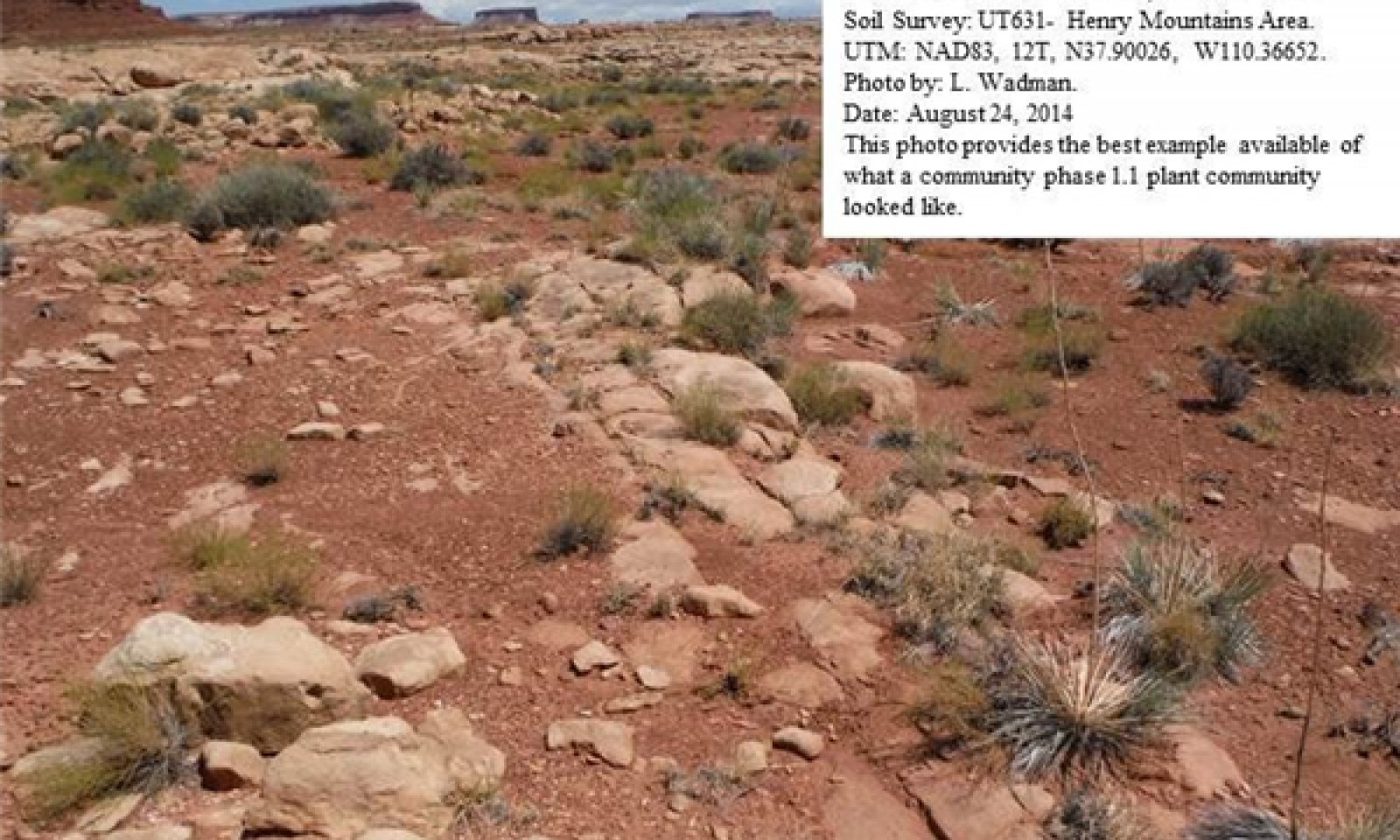
Blackbrush/Mixed Shrub Community Phase.
Figure 6. Community Phase 1.1

Figure 7. Community Phase 1.1
This community phase is characterized by a shrub layer dominated by wide mix of shrubs including blackbrush, littleleaf mountain mahogany, singleleaf ash, and Mexican cliffrose. Herbaceous species make up approximately 15 percent of sites biomass. Important understory species include James galleta and Wright's birdbeak. The appearance of most forbs is episodic in nature and is closely tied to precipitation events. Other herbaceous species commonly found on the site include desert princesplume and scarlet globemallow.
Air dry weight is approximately 5 percent forbs, 10 percent grasses and 85 percent shrubs. Bare ground is variable (2-55%) depending on biological crust cover, which is also variable (0-64%) and surface rock fragments (0-35%).
The following tables provide a typical example of the vegetative floristics of a community phase 1.1 plant community.Figure 8. Annual production by plant type (representative values) or group (midpoint values)
Table 5. Annual production by plant type
Plant type Low
(lb/acre)Representative value
(lb/acre)High
(lb/acre)Shrub/Vine 100 180 235 Grass/Grasslike 30 40 50 Forb 20 30 40 Total 150 250 325 Table 6. Ground cover
Tree foliar cover 0-30% Shrub/vine/liana foliar cover 10-40% Grass/grasslike foliar cover 0-20% Forb foliar cover 0-10% Non-vascular plants 0% Biological crusts 0-60% Litter 0-20% Surface fragments >0.25" and <=3" 0-20% Surface fragments >3" 0-10% Bedrock 0-20% Water 0% Bare ground 0-60% Table 7. Canopy structure (% cover)
Height Above Ground (ft) Tree Shrub/Vine Grass/
GrasslikeForb <0.5 – 0-5% 0-10% 0-10% >0.5 <= 1 – 0-10% 0-5% 0-5% >1 <= 2 – 5-10% 0-5% 0-5% >2 <= 4.5 – 5-20% – – >4.5 <= 13 0-15% – – – >13 <= 40 5-30% – – – >40 <= 80 – – – – >80 <= 120 – – – – >120 – – – – State 2
Current Potential StateThe Current Potential State is similar to the Reference Sate except that non-native species are now present. This state describes the plant communities that have or could become established on this ecological site under various successional sequences and disturbance conditions.
This state is composed of a broad mixture of shrubs including blackbrush, shadscale, littleleaf mountain mahogany, Mexican cliffrose and Torrey jointfir. Perennial cool and warm season grasses and perennial forbs are present in small amounts. Red brome, Russian thistle, various mustard species and other non-native species are present.
The primary disturbance mechanisms are the shrub layer density; the amount of invasive species present, the amount of run-on moisture and weather fluctuations. The current potential state is still self-sustaining but may be losing its resistance to change due to the impact of disturbances with less resilience following those disturbances.
Definitions:
Current Potential State: Plant communities influenced by shrub canopy density, long term weather fluctuations, and periodic fire. Invasive species are present in various amounts.
Indicators: A community dominated various shrubs and James galleta. The density of the shrub canopy determines the amount and composition of the other native and introduced grasses and forbs that may be present.
Feedbacks: Natural fluctuations in weather patterns that allow for a self sustaining mixed shrub and native grass community. Prolonged drought and/or other disturbances that may allow for the increase of invasive species.
At-risk Community Phase: All communities are at risk when native plants are stressed and nutrients become available for invasive plants to increase.
Trigger: A reduction of perennial grass and forb species combined with an increase of invasive plant species.Community 2.1
Blackbrush/Mixed Shrub/Invasive Weed Community Phase.
Figure 9. Community Phase 2.1

Figure 10. Community Phase 2.1
This community phase is characterized by a shrub layer dominated by a wide mix of shrubs including blackbrush, shadscale, littleleaf mountain mahogany, singleleaf ash, and Mexican cliffrose. Native herbaceous species make up
Figure 11. Annual production by plant type (representative values) or group (midpoint values)
Table 8. Annual production by plant type
Plant type Low
(lb/acre)Representative value
(lb/acre)High
(lb/acre)Shrub/Vine 100 180 235 Grass/Grasslike 30 40 50 Forb 20 30 40 Total 150 250 325 Table 9. Ground cover
Tree foliar cover 0-30% Shrub/vine/liana foliar cover 10-40% Grass/grasslike foliar cover 0-20% Forb foliar cover 0-10% Non-vascular plants 0% Biological crusts 0-60% Litter 0-20% Surface fragments >0.25" and <=3" 0-20% Surface fragments >3" 0-10% Bedrock 0-20% Water 0% Bare ground 0-60% Table 10. Canopy structure (% cover)
Height Above Ground (ft) Tree Shrub/Vine Grass/
GrasslikeForb <0.5 – 0-5% 0-10% 0-10% >0.5 <= 1 – 0-10% 0-5% 0-5% >1 <= 2 – 5-10% 0-5% 0-5% >2 <= 4.5 – 5-20% – – >4.5 <= 13 0-15% – – – >13 <= 40 5-30% – – – >40 <= 80 – – – – >80 <= 120 – – – – >120 – – – – Transition T1A
State 1 to 2This pathway describes the affects of the presence of a seed source of invasive and/or non-native species that become established by any combination of surface spot fire activity, drought, and improper livestock grazing. A threshold is passed when invasive and/or non-native species become established.
Transition T1A
State 1 to 2This transitional pathway describes the affects of long term drought, heavy wildlife browsing and the establishment of invasive species such as red brome and/or Russian thistle. A threshold is crossed when invasive species become established.
Additional community tables
Table 11. Community 1.1 plant community composition
Group Common name Symbol Scientific name Annual production () Foliar cover (%) Grass/Grasslike1 Dominant Grasses 25–75 James' galleta PLJA Pleuraphis jamesii 20–50 – Indian ricegrass ACHY Achnatherum hymenoides 10–30 – 2 Sub-Dominant Grasses 20–50 purple threeawn ARPU9 Aristida purpurea 20–30 – needle and thread HECOC8 Hesperostipa comata ssp. comata 20–30 – sand dropseed SPCR Sporobolus cryptandrus 20–30 – sixweeks fescue VUOC Vulpia octoflora 5–10 – New Mexico feathergrass HENE5 Hesperostipa neomexicana 5–10 – saline wildrye LESAS Leymus salinus ssp. salinus 5–10 – Sandberg bluegrass POSE Poa secunda 5–10 – spike dropseed SPCO4 Sporobolus contractus 5–10 – blue grama BOGR2 Bouteloua gracilis 5–10 – hairy woollygrass ERPI5 Erioneuron pilosum 5–10 – Grass, perennial 2GP Grass, perennial 5–10 – desert needlegrass ACSP12 Achnatherum speciosum 5–10 – Forb3 Forbs 20–50 Wright's bird's beak COWR2 Cordylanthus wrightii 20–40 – desert princesplume STPI Stanleya pinnata 20–30 – gooseberryleaf globemallow SPGR2 Sphaeralcea grossulariifolia 10–20 – desert trumpet ERIN4 Eriogonum inflatum 10–20 – Forb, annual 2FA Forb, annual 10–20 – Forb, perennial 2FP Forb, perennial 10–20 – tarragon ARDR4 Artemisia dracunculus 5–10 – woolly locoweed ASMO7 Astragalus mollissimus 5–10 – northwestern Indian paintbrush CAAN7 Castilleja angustifolia 5–10 – Fendler's sandmat CHFE3 Chamaesyce fendleri 5–10 – Parry's sandmat CHPA28 Chamaesyce parryi 5–10 – Brenda's yellow cryptantha CRFL5 Cryptantha flava 5–10 – wedgeleaf draba DRCU Draba cuneifolia 5–10 – winged buckwheat ERAL4 Eriogonum alatum 5–10 – shy gilia GIIN2 Gilia inconspicua 5–10 – fineleaf hymenopappus HYFI Hymenopappus filifolius 5–10 – hoary tansyaster MACA2 Machaeranthera canescens 5–10 – rock goldenrod PEPUP Petradoria pumila ssp. pumila 5–10 – Utah penstemon PEUT Penstemon utahensis 5–10 – woolly plantain PLPA2 Plantago patagonica 5–10 – hoary Townsend daisy TOIN Townsendia incana 5–10 – Shrub/Vine4 Dominant Shrubs 60–120 blackbrush CORA Coleogyne ramosissima 60–80 – singleleaf ash FRAN2 Fraxinus anomala 20–40 – Mexican cliffrose PUME Purshia mexicana 20–40 – shadscale saltbush ATCO Atriplex confertifolia 20–40 – littleleaf mountain mahogany CEIN7 Cercocarpus intricatus 20–40 – 5 Sub-Dominant Shrubs 50–150 rubber rabbitbrush ERNA10 Ericameria nauseosa 20–40 – broom snakeweed GUSA2 Gutierrezia sarothrae 20–40 – Havard oak QUHA3 Quercus havardii 20–30 – Whipple's fishhook cactus SCWH Sclerocactus whipplei 10–20 – roundleaf buffaloberry SHRO Shepherdia rotundifolia 10–20 – narrowleaf yucca YUAN2 Yucca angustissima 10–20 – plains pricklypear OPPO Opuntia polyacantha 10–20 – fourwing saltbush ATCA2 Atriplex canescens 10–20 – Cutler's jointfir EPCU Ephedra cutleri 10–20 – Torrey's jointfir EPTO Ephedra torreyana 10–20 – mormon tea EPVI Ephedra viridis 10–20 – crispleaf buckwheat ERCO14 Eriogonum corymbosum 10–20 – Table 12. Community 2.1 plant community composition
Group Common name Symbol Scientific name Annual production () Foliar cover (%) Grass/Grasslike1 Dominant Grasses 25–75 red brome BRRU2 Bromus rubens 30–50 – James' galleta PLJA Pleuraphis jamesii 20–50 – Indian ricegrass ACHY Achnatherum hymenoides 10–30 – 2 Sub-Dominant Grasses 20–50 needle and thread HECOC8 Hesperostipa comata ssp. comata 20–30 – sand dropseed SPCR Sporobolus cryptandrus 20–30 – purple threeawn ARPU9 Aristida purpurea 20–30 – blue grama BOGR2 Bouteloua gracilis 5–10 – hairy woollygrass ERPI5 Erioneuron pilosum 5–10 – sixweeks fescue VUOC Vulpia octoflora 5–10 – New Mexico feathergrass HENE5 Hesperostipa neomexicana 5–10 – saline wildrye LESAS Leymus salinus ssp. salinus 5–10 – Sandberg bluegrass POSE Poa secunda 5–10 – spike dropseed SPCO4 Sporobolus contractus 5–10 – Grass, perennial 2GP Grass, perennial 5–10 – desert needlegrass ACSP12 Achnatherum speciosum 5–10 – Forb3 Forbs 20–50 Wright's bird's beak COWR2 Cordylanthus wrightii 20–40 – Russian thistle SAKA Salsola kali 20–30 – tall tumblemustard SIAL2 Sisymbrium altissimum 20–30 – western tansymustard DEPI Descurainia pinnata 20–30 – herb sophia DESO2 Descurainia sophia 20–30 – crossflower CHTE2 Chorispora tenella 20–30 – desert princesplume STPI Stanleya pinnata 20–30 – Forb, annual 2FA Forb, annual 10–20 – Forb, perennial 2FP Forb, perennial 10–20 – gooseberryleaf globemallow SPGR2 Sphaeralcea grossulariifolia 10–20 – desert trumpet ERIN4 Eriogonum inflatum 10–20 – shy gilia GIIN2 Gilia inconspicua 5–10 – fineleaf hymenopappus HYFI Hymenopappus filifolius 5–10 – hoary tansyaster MACA2 Machaeranthera canescens 5–10 – rock goldenrod PEPUP Petradoria pumila ssp. pumila 5–10 – Utah penstemon PEUT Penstemon utahensis 5–10 – woolly plantain PLPA2 Plantago patagonica 5–10 – Brenda's yellow cryptantha CRFL5 Cryptantha flava 5–10 – tarragon ARDR4 Artemisia dracunculus 5–10 – woolly locoweed ASMO7 Astragalus mollissimus 5–10 – northwestern Indian paintbrush CAAN7 Castilleja angustifolia 5–10 – Fendler's sandmat CHFE3 Chamaesyce fendleri 5–10 – Parry's sandmat CHPA28 Chamaesyce parryi 5–10 – wedgeleaf draba DRCU Draba cuneifolia 5–10 – winged buckwheat ERAL4 Eriogonum alatum 5–10 – hoary Townsend daisy TOIN Townsendia incana 5–10 – Shrub/Vine4 Dominant Shrubs 60–120 blackbrush CORA Coleogyne ramosissima 60–80 – singleleaf ash FRAN2 Fraxinus anomala 20–40 – Mexican cliffrose PUME Purshia mexicana 20–40 – shadscale saltbush ATCO Atriplex confertifolia 20–40 – littleleaf mountain mahogany CEIN7 Cercocarpus intricatus 20–40 – 5 Sub-Dominant Shrubs 50–150 rubber rabbitbrush ERNA10 Ericameria nauseosa 20–40 – broom snakeweed GUSA2 Gutierrezia sarothrae 20–40 – Havard oak QUHA3 Quercus havardii 20–30 – Whipple's fishhook cactus SCWH Sclerocactus whipplei 10–20 – roundleaf buffaloberry SHRO Shepherdia rotundifolia 10–20 – narrowleaf yucca YUAN2 Yucca angustissima 10–20 – plains pricklypear OPPO Opuntia polyacantha 10–20 – fourwing saltbush ATCA2 Atriplex canescens 10–20 – Cutler's jointfir EPCU Ephedra cutleri 10–20 – Torrey's jointfir EPTO Ephedra torreyana 10–20 – mormon tea EPVI Ephedra viridis 10–20 – crispleaf buckwheat ERCO14 Eriogonum corymbosum 10–20 – Interpretations
Animal community
--Livestock and Wildlife Grazing--
Due to the very shallow soils and remote locations where this site is found, livestock grazing is generally not a factor. This site provides fair grazing conditions for wildlife. However, this site often lacks natural perennial water sources, which can influence the suitability for wildlife grazing. Mule deer, desert bighorn sheep, pronghorn antelope, and elk may utilize this site, though in many places the populations will be small and have little grazing impact.
The plant community is primarily shrubs, with the majority of canopy cover being attributed to blackbrush and shadscale; sub-dominants include Mexican cliffrose and singleleaf ash. These shrubs provide fair year round browse for bighorn sheep, mule deer, elk and pronghorn antelope. When present, grasses, primarily James galleta and Indian ricegrass, provide good grazing conditions for all classes of wildlife. Forb composition and annual production depends primarily on precipitation amounts and thus is challenging to use in wildlife use interpretations.Hydrological functions
The soils associated with this ecological site are generally in Hydrologic Soil Group D due to the shallow depth (NRCS National Engineering Handbook). These soils are saturated quickly due to high infiltration rates and shallow depth; once soils are saturated, run off potential is high. Hydrological groups are used in equations that estimate runoff from rainfall. These estimates are needed for solving hydrologic problems that arise in planning watershed-protection and flood-prevention projects and for designing structures for the use, control and disposal of water. (National Range and Pasture Handbook, 2003).
Recreational uses
Recreation activities include aesthetic value and fair opportunities for hiking and hunting. In good condition there are several forbs and shrubs that bloom in the spring. Shallow soils limit this site’s ability to be used for vacation homes, other residences, or deep ponds.
Wood products
None.
Other information
--Poisonous/Toxic Plant Communities--
Toxic plants associated with this site include woolly locoweed, broom snakeweed, and dwarf milkweed. Woolly locoweed is toxic to all classes of livestock and wildlife. Locoweed is palatable and has similar nutrient value to alfalfa, which may cause animals to consume it even when other forage is available. Locoweed contains swainsonine (indolizdine alkaloid) and is poisonous at all stages of growth. Poisoning will become evident after 2-3 weeks of continuous grazing and is associated with 4 major symptoms: 1) neurological damage, 2) emaciation, 3) reproductive failure and abortion, and 4) congestive heart failure linked with “high mountain disease”. Broom snakeweed contains steroids, terpenoids, saponins, and flavones that can cause abortions or reproductive failure in sheep and cattle, however cattle are most susceptible. These toxins are most abundant during active growth and leafing stage. Cattle and sheep will generally only graze broom snakeweed when other forage is unavailable, typically in winter when toxicity levels are at their lowest. Dwarf milkweed contains toxic cardiac glycosides and is poisonous to sheep, goats, cattle, and horses. Milkweeds are highly toxic during the vegetative state and retain their toxicity throughout the growing season and into dormancy. Clinical signs include labored breathing, muscle tremors, staggering, colic, and inability to stand.
Potentially toxic plants associated with this site include fourwing saltbush and some buckwheat species, which may accumulate selenium, but only when growing on selenium enriched soils. These plants, when consumed will cause alkali disease or chronic selenosis, which affects all classes of livestock (excluding goats). Typically animals consuming 5-50 ppm selenium will develop chronic selenosis and animals consuming greater than 50 ppm selenium will develop acute selenosis. Clinical signs include lameness, soughing of the hoof, hair loss, blindness, and aimless wondering. Horses tend to develop what is called a “bob” tail or “roached” main due to breakage of the long hairs.
Russian thistle is an invasive toxic plant, causing nitrate and to a lesser extent oxalate poisoning, which affects all classes of livestock. The buildup of nitrates in these plants is highly dependent upon environmental factors, such as after a rain storm during a drought, cool/cloudy days, and soils high in nitrogen and low in sulfur and phosphorus, all which cause increased nitrate accumulation. Nitrate collects in the stems and can persist throughout the growing season. Clinical signs of nitrate poisoning include drowsiness, weakness, muscular tremors, increased heart and respiratory rates, staggering gait, and death. Conversely, oxalate poisoning causes kidney failure; clinical signs include muscle tremors, tetany, weakness, and depression. Poisoning generally occurs when livestock consume and are not accustomed to grazing oxalate-containing plants. Animals with prior exposure to oxalates have increased numbers of oxalate-degrading rumen microflora and thus are able to degrade the toxin before clinical poisoning can occur.
--Invasive Plant Communities--
Generally as ecological conditions deteriorate and perennial vegetation decreases due to disturbance (fire, drought, off road vehicle overuse, erosion, etc.) annual forbs and grasses will invade the site. Of particular concern in semi-arid environments are annual invaders including cheatgrass, Russian thistle, halogeton, and annual mustards. The presence of these species will depend on soil properties and moisture availability; however, these invaders are highly adaptive and can flourish in many locations. Once established, complete removal is difficult but suppression may be possible. At this time, in most of the Colorado Plateau area, cheatgrass is not known to invade blackbrush associations as it does in areas of southwest Utah and the Mojave.
--Fire Ecology--
The ability for an ecological site to carry fire depends primarily on the present fuel load and plant moisture content—sites with small fuel loads will burn more slowly and less intensely than sites with large fuel loads. Many semi-desert communities in the Colorado Plateau may have evolved without the influence of fire. However a year of exceptionally heavy winter rains can generate fuels by producing heavy stands of annual forbs and grasses. When fires do occur, the effect on the plant community may be extreme due to the harsh environment and slow rate of recovery.
The fire regime for blackbrush is not well understood due to few species in the association that show fire scars and can be aged. Research has noted that a burned blackbrush site in Arizona has recovered, and in Nevada, fire in blackbrush communities has increased forage diversity. In these areas, a fire return interval has been suggested at 35-100 years. However, communities in southeastern Utah do not show evidence of burning within that time frame. This ecological site is comprised of dense to scattered low stature blackbrush plants with bare interspaces to patchy occurrence of grasses, which is unlikely to carry a fire unless under high winds, high temperature, and low humidity. Blackbrush is a non-sprouter and is slow to re-establish on burned sites. Studies indicate that blackbrush sites do not recover well in Utah. So currently burning is not a recommended brush management tool. Because of the apical dominance trait, removal through grazing or mechanical treatment will increase sprouting/new growth. If at sometime there are species that can be used successfully to re-vegetate the community, then mechanical treatment could be used. Of caution, blackbrush is thought to be very flammable due to the dense spacing of the brush and the tinder-like nature, and resinous foliage. So, if annual grasses or forbs dominate the area after disturbance, re-vegetating efforts could be hampered due to several factors including an increase in fire frequency.Supporting information
Other references
Relative Forage Preference of Plants for Grazing Use by Season: Plants commonly found in Major Land Resource Area D35 --The Colorado Plateau. 2007
Stubbendieck, J., S. L. Hatch, and C. H. Butterfield. 1997. North American range plants. Lincoln, NE: University of Nebraska Press. 501p.
USDA, Forest Service. 2007. Fire effects information: plant species life form. Available at http://www.fs.fed.us/database/feis/plants/index.html. Accessed 7 August 2007.
West, N. E. 1983. Colorado plateau-Mohavian blackbrush semi-desert. In: West, Neil E., ed. Temperate deserts and semi-deserts. New York: Elsevier Scientific Publishing Company: 399-411. (Goodall, David W., ed. in chief; Ecosystems of the world; vol. 5). [2508]
Knight, A. P. and R. G. Walter. 2001. A guide to plant poisoning of animals in North America. Jackson, WY: Teton NewMedia. 367p.
USDA, Forest Service. 2007. Fire effects information: plant species life form. Available at http://www.fs.fed.us/database/feis/plants/index.html. Accessed 7 August 2007.Contributors
V. Keith Wadman
Rangeland health reference sheet
Interpreting Indicators of Rangeland Health is a qualitative assessment protocol used to determine ecosystem condition based on benchmark characteristics described in the Reference Sheet. A suite of 17 (or more) indicators are typically considered in an assessment. The ecological site(s) representative of an assessment location must be known prior to applying the protocol and must be verified based on soils and climate. Current plant community cannot be used to identify the ecological site.
Author(s)/participant(s) Author(s)/participant(s): Fee Busby (USU), Dana Truman (NRCS), Paul Curtis (BLM), Shane A. Green (NRCS), Randy Beckstrand (BLM), Robert Stager (BLM). (Updated to include new concepts and terminology by V. Keith Wadman). Contact for lead author shane.green@ut.usda.gov Date 09/08/2014 Approved by Approval date Composition (Indicators 10 and 12) based on Annual Production Indicators
-
Number and extent of rills:
Rills are not present in the reference state on the gentler slopes. Very few rills may present on slopes exceeding 10%. Rills are more likely to form below adjacent sandstone bedrock or where water flow patterns are sufficient to cause erosion. Any rills present should be small (<1/2 inch deep and less than 6 feet in length. The number of rills can increase immediately following large storm events but should not persist more than one or two seasons due to coarse soil textures and frost-heave recovery. -
Presence of water flow patterns:
Water flow patterns are rare (0-3% cover) on all slopes and should be less than 3 feet long. As slopes increase (>10%) water flow pattern occurrence increases (3-8% cover) and length (3-5ft) also increases. An increase in water flow patterns next to sandstone bedrock is expected after disturbance events such as heavy precipitation events occur. -
Number and height of erosional pedestals or terracettes:
The occurrence of pedestalling or terracetting in the reference state is rare; however 1/2 inch pedestalling on shrubs is acceptable, but there should be no exposed roots. -
Bare ground from Ecological Site Description or other studies (rock, litter, lichen, moss, plant canopy are not bare ground):
Bare ground is variable (2-55%) throughout all plant community phases. Bare ground is associated with water flow patterns, rodent activity, and plant interspaces. Areas with poorly developed biological soils crust that are interpreted as functioning as bare ground should be recorded as bare ground. This site can have up to 35% surface rock cover. -
Number of gullies and erosion associated with gullies:
Active gullies are generally nonexistent; however, stable gullies may occur in landscape settings where increased runoff may have accumulated (such as areas below exposed bedrock). Any gully development is expected to be limited to steeper slopes, show little sign of accelerated erosion, and be stabilized with perennial vegetation. -
Extent of wind scoured, blowouts and/or depositional areas:
Minor wind generated soil movement is normal. Wind caused blowouts and depositions are mostly small, stable or have healed over. Some minor coppice mounding around shrubs is common. Increased wind generated soil movement can occur after severe (multi-year) drought or severe wind events. -
Amount of litter movement (describe size and distance expected to travel):
Most litter resides in place with some redistribution caused by water movement and wind. Fine litter (<¼ inch in diameter) may be moved up to 2-3 ft and usually occurs in water flow patterns and rills, with deposition occurring at obstruction. The majority of litter accumulates at the base of plants or in soil depressions adjacent to the plant. Woody stems (those greater than .25 inch in diameter) are not likely to move under normal conditions. -
Soil surface (top few mm) resistance to erosion (stability values are averages - most sites will show a range of values):
This site should have an average soil stability rating of 4 throughout the site. Surface texture varies from loams to fine sandy loams. -
Soil surface structure and SOM content (include type of structure and A-horizon color and thickness):
(Travessilla) Soil surface 0-4 inches deep and structure is weak fine granular. The A-horizon is light reddish brown (5YR 6/2). Surface textures are typically stony loams to fine sandy loams. The A-horizon typically exhibits minor development. Use the specific information for the soil you are assessing found in the published soil survey to supplement this description. -
Effect of community phase composition (relative proportion of different functional groups) and spatial distribution on infiltration and runoff:
The presence of overstory trees, shrubs, and perennial grasses break raindrop impact and splash erosion. The spatial distribution of vascular plants, non-vascular communities (when present), and interspaces provide detention storage and surface roughness that slows down runoff, allowing some time for infiltration. -
Presence and thickness of compaction layer (usually none; describe soil profile features which may be mistaken for compaction on this site):
None. Sandstone bedrock typically occurs at 8 inches. -
Functional/Structural Groups (list in order of descending dominance by above-ground annual-production or live foliar cover using symbols: >>, >, = to indicate much greater than, greater than, and equal to):
Dominant:
Trees (Utah juniper/Two-needle pinyon) > non sprouting shrubs (blackbrush/Mexican cliffrose/ littleleaf mountain mahogany) > Perennial grasses (James Galleta/Indian ricegrass).Sub-dominant:
Sprouting shrubs (Mormontea/ Rabbitbrush) = forbs (globemallow, princesplume) > Biological soil crust.Other:
Functional/structural groups may appropriately contain non-native species if their ecological function is the same as the native species in the reference state. Biological soil crust is variable in it’s occurrence on this site and when present, is measured as a component of ground cover. Forbs can be expected to vary widely in their expression in the plant community based upon departures from average growing conditions.Additional:
Temporal variability is caused by drought, insects and large precipitation events. Spatial variability is caused by soil textures, proximity to runoff producing sites, etc. Following a recent disturbance such as drought or insects that removes the woody vegetation, forbs and perennial grasses (herbaceous species) may dominate the community. If a disturbance has not occurred for an extended period of time, woody species may continue to increase, competing with the perennial herbaceous understory species. In either case, these conditions reflect a community phase within the reference state. -
Amount of plant mortality and decadence (include which functional groups are expected to show mortality or decadence):
During years with average to above average precipitation, there should be very little mortality or decadence apparent in either shrubs or grasses. Many plants may die during a multi-year drought. Some (up to 20%) perennial bunchgrass mortality is expected during severe drought. -
Average percent litter cover (%) and depth ( in):
Litter cover (including under plants) ranges from 10-20%, nearly all of which should be fine litter. Variability is due to the herbaceous production differences from one year to the next. Depth is generally 1 leaf thickness in the interspaces and up to 0.25 inches under plant canopies. Litter can increase up to 20% immediate following leaf drop or after favorable conditions increase native annual forb production. -
Expected annual annual-production (this is TOTAL above-ground annual-production, not just forage annual-production):
Annual production will average 250 per lbs/acre on an normal year. Production can range from 150 t0 325 during drought years or years with above average precipitation. -
Potential invasive (including noxious) species (native and non-native). List species which BOTH characterize degraded states and have the potential to become a dominant or co-dominant species on the ecological site if their future establishment and growth is not actively controlled by management interventions. Species that become dominant for only one to several years (e.g., short-term response to drought or wildfire) are not invasive plants. Note that unlike other indicators, we are describing what is NOT expected in the reference state for the ecological site:
Very few invasive species have been known to occupy this site. Known invasive species include Russian thistle and mustard species. -
Perennial plant reproductive capability:
All perennial plants should have the ability to reproduce sexually or asexually in most years, except during drought. -
Supporting Data::
NRCS (Dana Truman/Ashley Garrelts) 2006/2007 ESD data from Arches and Canyonlands National Parks.
Print Options
Sections
Font
AAAAOther
PrintThe Ecosystem Dynamics Interpretive Tool is an information system framework developed by the USDA-ARS Jornada Experimental Range, USDA Natural Resources Conservation Service, and New Mexico State University.
Accessibility statement