Natural Resources
Conservation Service
-
Search


Major Land Resource Area or ecological site by name and/or ID.
PreviousSectionsNextGeneral information
Draft. A draft ecological site description is either incomplete or has not undergone quality control and quality assurance review.
MLRA notes
Major Land Resource Area (MLRA): 035X–Colorado Plateau
This ecological site occurs in the northern portion of MLRA 35, Colorado Plateau Province. It is found principally in the High Plateaus of Utah section within that MLRA. This area has been stucturally uplifted over time while rivers flowing across it were cutting down into its bedrock. Areas of shale, sandstone, limestone, dolomite, and volcanic rock outcrop are found throughout the region.
Classification relationships
Semiarid Benchlands and Canyonlands, 20-c and Arid Canyonlands, 20-d. (Woods et al. 2001)
Colorado Plateau Semidesert Province (arid grassland zone), 313. (Baily 1995)
Associated sites
R035XY015UT Sandy Bottom
R035XY215UT Semidesert Sandy Loam (4-Wing Saltbush)
R035XY216UT Semidesert Sandy Loam (Wyoming Big Sagebrush)
R035XY218UT Semidesert Sandy Loam (Blackbrush)
R035XY221UT Semidesert Shallow Loam (Utah Juniper-Pinyon)
R035XY224UT Semidesert Shallow Sand (Blackbrush)
R035XY225UT Semidesert Shallow Sand (Cutler''s Jointfir)
R035XY227UT Semidesert Shallow Sand (Utah Juniper-Pinyon)
R035XY233UT Semidesert Shallow Sandy Loam (Blackbrush)
R035XY236UT Semidesert Shallow Sandy Loam (Utah Juniper, Blackbrush)
Similar sites
R035XY211UT Semidesert Sand (Dune)
R035XY118UT Desert Sandy Loam (Fourwing Saltbush)
R035XY215UT Semidesert Sandy Loam (4-Wing Saltbush)
Table 1. Dominant plant species
Tree Not specified
Shrub (1) Ephedra cutleri
(2) Atriplex canescensHerbaceous (1) Achnatherum hymenoides
(2) Pleuraphis jamesiiPhysiographic features
This site occurs on structural benches, plains on structural benches, fan remnants, and cuestas. Slopes range from 0 to 15 percent. Runoff potential is low.
Table 2. Representative physiographic features
Landforms (1) Structural bench
(2) Fan remnant
(3) Cuesta
Flooding frequency None Ponding frequency None Elevation 6000 – 6400 ft Slope 0 – 15 % Ponding depth 0 in Aspect Aspect is not a significant factor Climatic features
The climate is characterized by hot summers and cool winters, which can be slightly modified by local topographic conditions. Large fluctuations in daily temperature are common. Mean annual air temperatures range from 45-54 degrees Fahrenheit. Approximately 70-75% of moisture occurs from July thru March as convection thunderstorms and snow. Precipitation is extremely variable from month to month and from year to year but averages between 9-13 inches. Snow packs are generally light and not persistent.
Table 3 Representative climatic features
Frost-free period (average) 140 days Freeze-free period (average) 170 days Precipitation total (average) 10 in BarLineFigure 1. Monthly precipitation range
BarLineFigure 2. Monthly average minimum and maximum temperature
Figure 3. Annual precipitation pattern
Figure 4 Annual average temperature pattern
Climate stations used
-
(1) ESCALANTE [USC00422592], Escalante, UT
">Influencing water features
There are no water features influencing this site.
Soil features
This sites soils are classified as deep Ustic Haplocalcids and are well drained. The dry surface color is typically a reddish brown. Runoff potential is low. The soil temperature and moisture regimes are mesic and ustic aridic respectively. Surface and subsurface textures are generally very fine sandy loams. Soils are nonsaline and the water holding capacity is generally low. Surface rock fragments are unusual. This site has been used in the following soil surveys and has been correlated to the following components:
UT636 – Panguitch Area – Mivida
Typical soil profile:
A--0-7 inches; very fine sandy loam; slightly effervescent; moderately alkaline.
Bw1--7-16 inches; very fine sandy loam; moderately effervescent; strongly alkaline.
Bw2--16-22 inches; very fine sandy loam; moderately effervescent; strongly alkaline.
Bk1--22-52 inches; gravelly very fine sandy loam; strongly effervescent; strongly alkaline.
Bk2--52-60 inches; very fine sandy loam; strongly effervescent; strongly alkaline.
Table 4. Representative soil features
Parent material (1) Alluvium – sandstone
Surface texture (1) Very fine sandy loam
Family particle size (1) Sandy
Drainage class Well drained Permeability class Moderately rapid Soil depth 60 in Surface fragment cover <=3" Not specified Surface fragment cover >3" 0 – 6 % Available water capacity
(0-40in)3.9 – 5.1 in Calcium carbonate equivalent
(0-40in)5 – 10 % Electrical conductivity
(0-40in)Not specified Sodium adsorption ratio
(0-40in)Not specified Soil reaction (1:1 water)
(0-40in)7.9 – 8.4 Subsurface fragment volume <=3"
(Depth not specified)0 – 7 % Subsurface fragment volume >3"
(Depth not specified)Not specified Ecological dynamics
This ecological site occurs on deep to very deep, moderately well developed soils found on structural benches, fan reminants and cuestas in Major Land Resource Area (MLRA) 35-The Colorado Plateau. Cutler jointfir and fourwing saltbush typically form the dominant visual aspect. A mixture of warm and cool season grasses including Indian ricegrass, mesa dropseed, James galleta and blue grama form a dense herbaceous layer.
This site is small in extent, occurring in and around Escalante, Utah. Much of the site has been converted to cropland and homes. The site developed under Colorado Plateau climatic conditions and included natural influences of herbivory, fire, and climate. The natural disturbance regime consisted of fairly infrequent fires ignited by both natural causes and Native Americans. It is estimated that the historic fire return interval was 35-100+ years depending on fine fuel accumulations (Howard, 2003).
This ecological site has been grazed by domestic livestock since they were first introduced into the area. This livestock introduction, with its the use of fencing and the development of reliable water sources influenced the disturbance regime historically associated with this ecological site.
Fire would most typically occur on this site following several good moisture years which would create sufficient fine fuels for burning, followed by a source of ignition such as lightening. In some cases, this introduction of domestic livestock reduced these fine fuels, increasing fire periods. In addition to influencing this sites fire regime, improperly managed livestock grazing, where it occurred, may have caused this site to depart from the reference plant community. Continued improper domestic livestock grazing likely removed the native perennial grasses and shrubs from the system and created bare interspaces, which increased erosion, active duning, and created opportunities for invasive plants to establish.
Other disturbance mechanisms including extended drought, changes in the site’s drainage patterns, alluvial deposition, insect herbivory, off road vehicle use, and prolonged rodent activity can facilitate this sites transition into different plant communities or cause the transition from one stable state to another. Once these changes occur, a return to previous states may not be possible without major energy inputs.
The following State and Transition diagram describes the most common plant communities found on this site. They do not represent every possibility, but they are the most prevalent and repeatable. As more data are collected, some of these plant communities may be revised or removed, and new ones may be added. Both ocular and measured data was collected and utilized in developing this model.State and transition model
Custom diagramStandard diagram
Figure 5. R035XY214UT
More interactive model formats are also available. View Interactive Models
More interactive model formats are also available. View Interactive Models
Click on state and transition labels to scroll to the respective textState 1 submodel, plant communities
State 2 submodel, plant communities
State 3 submodel, plant communities
State 1
Reference StateThis Reference State describes the natural range of variability as influenced by the ecological dynamics of this site. This state includes those biotic communities that will become established when all successional sequences are completed under a natural disturbance regime. This state has a well developed shrub layer with Cutler jointfir and fourwing saltbush dominating. A mixture of other shrubs including Mexican cliffrose, Torrey jointfir and green rabbitbrush are common. The herbaceous layer is composed of both warm and cool season grasses and a diverse forb community. Utah juniper has been known to invade this site when it is in close proximity to a seed source.
Primary disturbance mechanisms for this site include fire, grazing by native herbivores, prolonged rodent activity, insect herbivory, alluvial deposition and changes in the sites drainage patterns. These disturbances coupled with weather events dictate the dynamics that occur within the natural range of variability. The reference state is self sustaining and resistant to change due to high resistance to natural disturbances and high resilience after natural disturbances. When natural disturbances occur, the rate of recovery is relatively rapid due to niches being filled with highly adapted native vegetation.
Terminology:
Reference State: Community phases influenced by fire, native herbivore grazing, insect herbivory, alluvial deposits, time without disturbance, and climate.
Indicators: A well developed native perennial warm and cool season grass community with a diverse shrub overstory, when present.
Feedbacks: Establishment of non-native invasive species in the understory. Infrequent but regular fires that maintain the perennial grass understory and the establishment of shrubs.
At-risk Community Phase: All communities are at risk for invasion by non-native plants.
Trigger: Establishment of non-native plant species
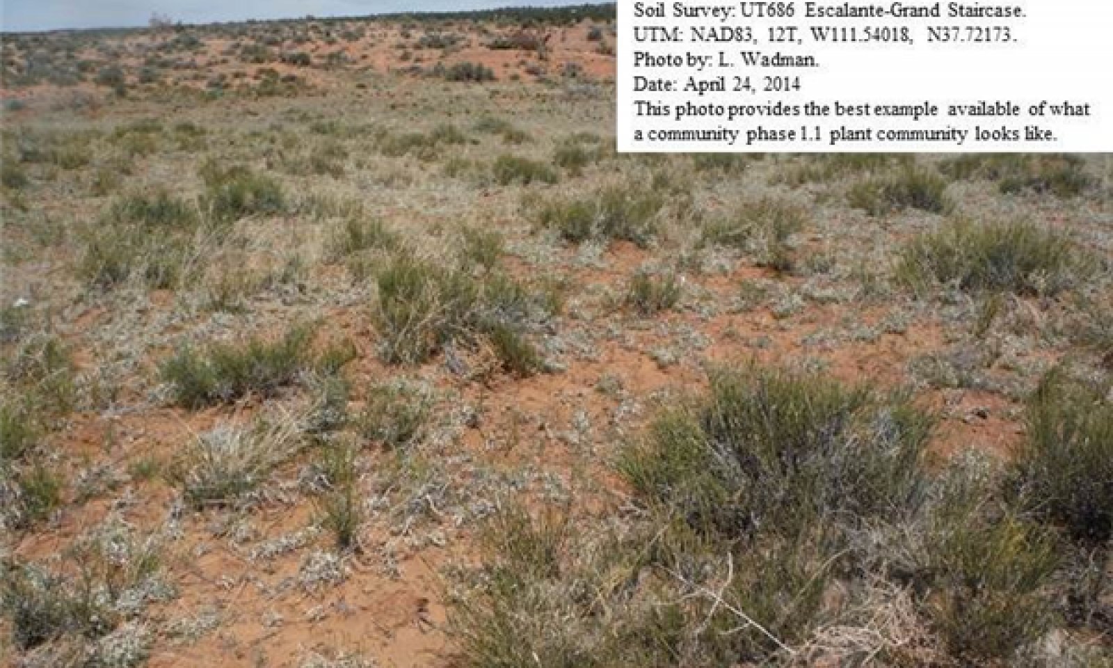
Community 1.1
Cutler Jointfir/Perennial Grass Community Phase.
Figure 6. Community Phase 1.1
This phase of the ecological site is characterized by a shrub layer dominated by Cutler jointfir, fourwing saltbush and Mexican cliffrose. A wide array of other shrubs are also commonly present. Indian ricegrass, mesa dropseed and James galleta dominate the herbaceous layer. Other commonly occurring herbaceous species include needle-and-thread, blue grama and scarlet globemallow. The appearance of most forbs is episodic in nature and is closely tied to precipitation events.
Air dry weight is approximately 50 percent shrubs, 10 percent forbs, and 40 percent grasses. Bare ground is variable (2-55%) depending on biological crust cover, which is also variable (0-64%).
The following tables present a typical example of the vegetative floristics of a community phase 1.1 plant community.Figure 7. Annual production by plant type (representative values) or group (midpoint values)
Table 5. Annual production by plant type
Plant type Low
(lb/acre)Representative value
(lb/acre)High
(lb/acre)Shrub/Vine 150 250 350 Grass/Grasslike 120 210 300 Forb 30 40 50 Total 300 500 700 Table 6. Soil surface cover
Tree basal cover 0-10% Shrub/vine/liana basal cover 10-10% Grass/grasslike basal cover 20-50% Forb basal cover 0-20% Non-vascular plants 0% Biological crusts 20-30% Litter 10-10% Surface fragments >0.25" and <=3" 0-10% Surface fragments >3" 0% Bedrock 0% Water 0% Bare ground 10-20% Table 7. Canopy structure (% cover)
Height Above Ground (ft) Tree Shrub/Vine Grass/
GrasslikeForb <0.5 – 1-10% 0-10% 0-5% >0.5 <= 1 – 1-5% 5-10% 0-5% >1 <= 2 – 1-10% 5-20% 0-5% >2 <= 4.5 – 1-5% 5-20% 0-5% >4.5 <= 13 0-5% 1-3% – – >13 <= 40 – – – – >40 <= 80 – – – – >80 <= 120 – – – – >120 – – – – Community 1.2
Fourwing saltbush/Perennial Grass Community Phase.
Figure 8. Community Phase 1.2
This phase of the ecological site is characterized by a shrub layer dominated by fourwing saltbush. Cutler jointfir, Mexican cliffrose and a wide array of other shrubs are also commonly present. Indian ricegrass, mesa dropseed and James galleta dominate the herbaceous layer. Other commonly occurring herbaceous species include needle-and-thread, blue grama and scarlet globemallow. The appearance of most forbs is episodic in nature and is closely tied to precipitation events.
Air dry weight is approximately 30 percent shrubs, 10 percent forbs, and 60 percent grasses. Bare ground is variable (2-55%) depending on biological crust cover, which is also variable (0-64%).
The following tables present a typical example of the vegetative floristics of a community phase 1.2 plant community.Figure 9. Annual production by plant type (representative values) or group (midpoint values)
Table 8. Annual production by plant type
Plant type Low
(lb/acre)Representative value
(lb/acre)High
(lb/acre)Shrub/Vine 150 250 350 Grass/Grasslike 120 210 300 Forb 30 40 50 Total 300 500 700 Table 9. Soil surface cover
Tree basal cover 0-10% Shrub/vine/liana basal cover 10-10% Grass/grasslike basal cover 20-50% Forb basal cover 0-20% Non-vascular plants 0% Biological crusts 20-30% Litter 10-10% Surface fragments >0.25" and <=3" 0-10% Surface fragments >3" 0% Bedrock 0% Water 0% Bare ground 10-20% Table 10. Canopy structure (% cover)
Height Above Ground (ft) Tree Shrub/Vine Grass/
GrasslikeForb <0.5 – 1-10% 0-10% 0-5% >0.5 <= 1 – 1-5% 5-10% 0-5% >1 <= 2 – 1-10% 5-20% 0-5% >2 <= 4.5 – 1-5% 5-20% 0-5% >4.5 <= 13 0-5% 1-3% – – >13 <= 40 – – – – >40 <= 80 – – – – >80 <= 120 – – – – >120 – – – – Pathway 1.1A
Community 1.1 to 1.2
Cutler Jointfir/Perennial Grass Community Phase.
Fourwing saltbush/Perennial Grass Community Phase.This pathway describes the affects of any combination of fire activity and wet weather periods which will increase the amount herbaceous vegetation. Good livestock management and moderate wildlife browsing will allow for improved vigor in herbaceous species.
Pathway 1.2A
Community 1.2 to 1.1
Fourwing saltbush/Perennial Grass Community Phase.
Cutler Jointfir/Perennial Grass Community Phase.This pathway describes the affects of a long term drought that does not allow for sufficient precipitation to support herbaceous species and/or long periods without fire. Light wildlife browsing can allow for shrub recovery, reducing available moisture for herbaceous species.
State 2
Current Potential StateThe Current Potential State has invasive, non-native plant species present in all plant community phases. The primary disturbance mechanisms in this state can be natural or human induced. Events, such as improper livestock grazing, prolonged rodent activity, changes in historic fire regimes, improper OHV use, insect herbivory, or drought may influence this site. Any shift in species composition will affect nutrient cycling, soil-water relationships, hydrology, and soil stability.
Dominant grasses include both warm and cool season; however many times heavy spring grazing will remove the cool season grasses and heavy late summer and early fall grazing will remove the warm season grasses. Utah juniper is a common invader on this site potentially creating blowout areas and increasing erosion. This state is losing resistance to disturbances and resilience after disturbance. Invasive plants are beginning to fill the niches and establish on the site.
Terminology:
Current Potential State: Plant communities influenced by both natural and man influenced events, including rodent activity, improper OHV use, livestock grazing, insect herbivory, fire, time with out disturbances, and climatic fluctuations.
Indicators: A perennial cool and warm season grass understory with basin big sage or fourwing saltbush forming the dominant visual aspect, when present. Non-native species are now present in all plant communities.
Feedbacks: Extended drought, improper livestock grazing, or other disturbance that changes the ecological dynamics of the site. Infrequent but regular fires or properly managed domestic livestock grazing to maintain the understory and the establishment of shrubs.
At-risk Community Phase: All communities are at risk; however plant community 2.1 is most at risk due to its limited understory.
Trigger: Disturbance that facilitates the dominance of invasive forbs and/or grasses.Community 2.1
Basin Big Sage/James galleta/Invasive weed Community Phase.
Figure 10. Community Phase 2.1
This phase of the ecological site is characterized by a shrub layer dominated by basin big sage. Fourwing saltbush, Mexican cliffrose and a wide array of other shrubs are also commonly present. James galleta and blue grama dominate the herbaceous layer. Most cool season grasses are much reduced. Invasive species including Russian thistle, cheatgrass, redstem storksbill and various mustard species and common and may dominate the understory.
Air dry weight is approximately 60 percent shrubs, 10 percent forbs, and 30 percent grasses. Bare ground is variable (2-55%) depending on biological crust cover, which is also variable (0-64%).
The following tables present a typical example of the vegetative floristics of a community phase 2.1 plant community.Figure 11. Annual production by plant type (representative values) or group (midpoint values)
Table 11. Annual production by plant type
Plant type Low
(lb/acre)Representative value
(lb/acre)High
(lb/acre)Shrub/Vine 150 250 350 Grass/Grasslike 120 210 300 Forb 30 40 50 Total 300 500 700 Table 12. Soil surface cover
Tree basal cover 0-10% Shrub/vine/liana basal cover 10-10% Grass/grasslike basal cover 20-50% Forb basal cover 0-20% Non-vascular plants 0% Biological crusts 20-30% Litter 10-10% Surface fragments >0.25" and <=3" 0-10% Surface fragments >3" 0% Bedrock 0% Water 0% Bare ground 10-20% Table 13. Canopy structure (% cover)
Height Above Ground (ft) Tree Shrub/Vine Grass/
GrasslikeForb <0.5 – 1-10% 0-10% 0-5% >0.5 <= 1 – 1-5% 5-10% 0-5% >1 <= 2 – 1-10% 5-20% 0-5% >2 <= 4.5 – 1-5% 5-20% 0-5% >4.5 <= 13 0-5% 1-3% – – >13 <= 40 – – – – >40 <= 80 – – – – >80 <= 120 – – – – >120 – – – – Community 2.2
Utah Juniper/warm Season Grass/Invasive weed Community Phase.
Figure 12. Community Phase 2.2
This phase of the ecological site is being invaded by Utah juniper. A shrub layer composed of basin big sage, fourwing saltbush, Mexican cliffrose and a wide array of other shrubs is commonly present. James galleta and blue grama dominate the herbaceous layer. Most cool season grasses are much reduced. Invasive species including Russian thistle, cheatgrass, redstem storksbill and various mustard species and common and may dominate the understory.
Air dry weight is approximately 60 percent shrubs, 10 percent forbs, and 30 percent grasses. Bare ground is variable (2-55%) depending on biological crust cover, which is also variable (0-64%).
The following tables present a typical example of the vegetative floristics of a community phase 2.2 plant community.Figure 13. Annual production by plant type (representative values) or group (midpoint values)
Table 14. Annual production by plant type
Plant type Low
(lb/acre)Representative value
(lb/acre)High
(lb/acre)Shrub/Vine 140 235 325 Grass/Grasslike 55 125 200 Tree 75 100 125 Forb 30 40 50 Total 300 500 700 Table 15. Soil surface cover
Tree basal cover 0-10% Shrub/vine/liana basal cover 10-10% Grass/grasslike basal cover 20-50% Forb basal cover 0-20% Non-vascular plants 0% Biological crusts 20-30% Litter 10-10% Surface fragments >0.25" and <=3" 0-10% Surface fragments >3" 0% Bedrock 0% Water 0% Bare ground 10-20% Table 16. Canopy structure (% cover)
Height Above Ground (ft) Tree Shrub/Vine Grass/
GrasslikeForb <0.5 – 1-10% 0-10% 0-5% >0.5 <= 1 – 1-5% 5-10% 0-5% >1 <= 2 – 1-10% 5-20% 0-5% >2 <= 4.5 – 1-5% 5-20% 0-5% >4.5 <= 13 0-5% 1-3% – – >13 <= 40 – – – – >40 <= 80 – – – – >80 <= 120 – – – – >120 – – – – Pathway 2.1A
Community 2.1 to 2.2
Basin Big Sage/James galleta/Invasive weed Community Phase.
Utah Juniper/warm Season Grass/Invasive weed Community Phase.This pathway describes the affects of a long term drought that does not allow for sufficient precipitation to support herbaceous species and/or long periods without fire. Heavy livestock grazing and/or heavy wildlife browsing of palatable shrubs can allow for Utah juniper to invade the site, reducing available moisture shrub and herbaceous species.
Pathway 2.2A
Community 2.2 to 2.1
Utah Juniper/warm Season Grass/Invasive weed Community Phase.
Basin Big Sage/James galleta/Invasive weed Community Phase.This pathway describes the affects of any combination of no fire activity and wet weather periods which will increase the amount herbaceous vegetation on the site. Good livestock management and moderate wildlife browsing will allow for improved vigor in palatable woody and herbaceous species.
State 3
Chained/Disked StateThe Chained/Disked State of this ecological site has need mechanically altered to remove Utah juniper and or basin big sage. A significant portion of this site has been deep disked to remove all vegetation creating a fertile seedbed for invasive weeds to thrive.
Where chaining has occurred, dominant grasses include both warm and cool season may be recovering; careful livestock management is necessary for good recovery to occur. Where heavy spring grazing is allowed to occur, cool season grasses are removed, and heavy late summer and early fall grazing will remove the warm season grasses.
Following deep disking, all perennial vegetation is removed from the site. This site is then often completely dominated by aggressive invasive annuals.
This state has lost significant resistance to disturbances and resilience after disturbance.
Terminology:
Current Potential State: Plant communities influenced by both natural and man influenced events, including chaining, disking, rodent activity, improper OHV use, livestock grazing, insect herbivory, fire, time with out disturbances, and climatic fluctuations.
Indicators: Non-native species are now present in all plant communities.
Feedbacks: Extended drought, improper livestock grazing, or other disturbance that changes the ecological dynamics of the site.
At-risk Community Phase: All communities are at risk.
Trigger: Disturbance that facilitates the dominance of invasive forbs and/or grasses.Community 3.1
Chained/Perennial Grass/Invasive weed Community Phase.
Figure 14. Community Phase 3.1
This phase of the ecological site has been chained to remove Utah juniper. A shrub layer composed of basin big sage, fourwing saltbush, Mexican cliffrose and a wide array of other shrubs is commonly present. James galleta and blue grama dominate the herbaceous layer. Most cool season grasses are much reduced. Invasive species including Russian thistle, cheatgrass, redstem storksbill and various mustard species and common and may dominate the understory.
Air dry weight is approximately 60 percent shrubs, 10 percent forbs, and 30 percent grasses. Bare ground is variable (2-55%) depending on biological crust cover, which is also variable (0-64%).
The following tables present a typical example of the vegetative floristics of a community phase 3.1 plant community.Figure 15. Annual production by plant type (representative values) or group (midpoint values)
Table 17. Annual production by plant type
Plant type Low
(lb/acre)Representative value
(lb/acre)High
(lb/acre)Shrub/Vine 140 235 325 Grass/Grasslike 55 125 200 Tree 75 100 125 Forb 30 40 50 Total 300 500 700 Table 18. Soil surface cover
Tree basal cover 0-10% Shrub/vine/liana basal cover 10-10% Grass/grasslike basal cover 20-50% Forb basal cover 0-20% Non-vascular plants 0% Biological crusts 20-30% Litter 10-10% Surface fragments >0.25" and <=3" 0-10% Surface fragments >3" 0% Bedrock 0% Water 0% Bare ground 10-20% Table 19. Canopy structure (% cover)
Height Above Ground (ft) Tree Shrub/Vine Grass/
GrasslikeForb <0.5 – 1-10% 0-10% 0-5% >0.5 <= 1 – 1-5% 5-10% 0-5% >1 <= 2 – 1-10% 5-20% 0-5% >2 <= 4.5 – 1-5% 5-20% 0-5% >4.5 <= 13 0-5% 1-3% – – >13 <= 40 – – – – >40 <= 80 – – – – >80 <= 120 – – – – >120 – – – – Community 3.2
Disked/Invasive weed Community Phase.
Figure 16. Community Phase 3.2
This phase of the ecological site has been deep disked to remove all vegetation. A few perennial grasses including Indian ricegrass, James galleta and blue grama may still be present. Most cool season grasses are much reduced. Invasive species including Russian thistle, cheatgrass, redstem storksbill and various mustard species and common and often dominate the understory.
Air dry weight is approximately 5 percent shrubs, 75 percent forbs, and 20 percent grasses. Bare ground is variable (2-55%) depending on biological crust cover, which is also variable (0-64%).
The following tables present a typical example of the vegetative floristics of a community phase 3.2 plant community.Figure 17. Annual production by plant type (representative values) or group (midpoint values)
Table 20. Annual production by plant type
Plant type Low
(lb/acre)Representative value
(lb/acre)High
(lb/acre)Shrub/Vine 120 175 225 Forb 100 150 200 Grass/Grasslike 55 125 200 Tree 25 50 75 Total 300 500 700 Table 21. Soil surface cover
Tree basal cover 0-10% Shrub/vine/liana basal cover 10-10% Grass/grasslike basal cover 20-50% Forb basal cover 0-20% Non-vascular plants 0% Biological crusts 20-30% Litter 10-10% Surface fragments >0.25" and <=3" 0-10% Surface fragments >3" 0% Bedrock 0% Water 0% Bare ground 10-20% Table 22. Canopy structure (% cover)
Height Above Ground (ft) Tree Shrub/Vine Grass/
GrasslikeForb <0.5 – 1-10% 0-10% 0-5% >0.5 <= 1 – 1-5% 5-10% 0-5% >1 <= 2 – 1-10% 5-20% 0-5% >2 <= 4.5 – 1-5% 5-20% 0-5% >4.5 <= 13 0-5% 1-3% – – >13 <= 40 – – – – >40 <= 80 – – – – >80 <= 120 – – – – >120 – – – – Pathway 3.1A
Community 3.1 to 3.2
Chained/Perennial Grass/Invasive weed Community Phase.
Disked/Invasive weed Community Phase.This pathway describes the affects deep disking on the site. All site vegetation is removed.
Pathway 3.2A
Community 3.2 to 3.1
Disked/Invasive weed Community Phase.
Chained/Perennial Grass/Invasive weed Community Phase.This pathway describes the affects of weather periods which will increase the amount herbaceous vegetation on the site. Good livestock management and moderate wildlife browsing will allow for improved vigor in any palatable woody and herbaceous species present.
Transition T1A
State 1 to 2This pathway describes the affects of long term drought that does not allow for sufficient precipitation to support herbaceous species and/or long periods without fire. Heavy wildlife browsing can allow for non-palatable shrubs to increase. Heavy livestock grazing will reduce palatable herbaceous species.
Transition T2A
State 2 to 3This pathway describes the affects of chaining or disking to remove unwanted vegetation. Chaining is intended remove Utah juniper and/or basin big sage. Disking is used to convert site to other land uses such as farm land or urban land.
Additional community tables
Table 23. Community 1.1 plant community composition
Group Common name Symbol Scientific name Annual production () Foliar cover (%) Grass/Grasslike1 Dominant Grasses 75–150 Indian ricegrass ACHY Achnatherum hymenoides 50–100 – James' galleta PLJA Pleuraphis jamesii 20–40 – mesa dropseed SPFL2 Sporobolus flexuosus 20–40 – 2 Sub-Dominant Grasses 100–200 Grass, perennial 2GP Grass, perennial 10–20 – purple threeawn ARPU9 Aristida purpurea 10–20 – blue grama BOGR2 Bouteloua gracilis 10–20 – needle and thread HECO26 Hesperostipa comata 10–20 – sandhill muhly MUPU2 Muhlenbergia pungens 10–20 – spike dropseed SPCO4 Sporobolus contractus 10–20 – sand dropseed SPCR Sporobolus cryptandrus 10–20 – Forb3 Forbs 40–50 Forb, annual 2FA Forb, annual 10–20 – Forb, perennial 2FP Forb, perennial 10–20 – snowball sand verbena ABFR2 Abronia fragrans 10–20 – Douglas' dustymaiden CHDO Chaenactis douglasii 10–20 – Wright's bird's beak COWR2 Cordylanthus wrightii 10–20 – fineleaf hymenopappus HYFI Hymenopappus filifolius 10–20 – manybranched ipomopsis IPPO2 Ipomopsis polycladon 10–20 – Gray's biscuitroot LOGR Lomatium grayi 10–20 – hoary tansyaster MACA2 Machaeranthera canescens 10–20 – pale evening primrose OEPA Oenothera pallida 10–20 – lobeleaf groundsel PAMU11 Packera multilobata 10–20 – skyblue phacelia PHCO Phacelia coerulea 10–20 – woolly plantain PLPA2 Plantago patagonica 10–20 – sand dropseed SPCR Sporobolus cryptandrus 10–20 – desert princesplume STPI Stanleya pinnata 10–20 – matted crinklemat TILA6 Tiquilia latior 10–20 – yellow salsify TRDU Tragopogon dubius 10–20 – Shrub/Vine4 Dominant Shrubs 100–150 fourwing saltbush ATCA2 Atriplex canescens 40–60 – Cutler's jointfir EPCU Ephedra cutleri 40–60 – Mexican cliffrose PUME Purshia mexicana 20–40 – 5 Sub-Dominant Shrubs 50–100 Shrub (>.5m) 2SHRUB Shrub (>.5m) 10–20 – sand sagebrush ARFI2 Artemisia filifolia 10–20 – basin big sagebrush ARTRT Artemisia tridentata ssp. tridentata 10–20 – yellow rabbitbrush CHVI8 Chrysothamnus viscidiflorus 10–20 – Torrey's jointfir EPTO Ephedra torreyana 10–20 – sand buckwheat ERLE9 Eriogonum leptocladon 10–20 – rubber rabbitbrush ERNA10 Ericameria nauseosa 10–20 – broom snakeweed GUSA2 Gutierrezia sarothrae 10–20 – brittle pricklypear OPFR Opuntia fragilis 10–20 – plains pricklypear OPPO Opuntia polyacantha 10–20 – Spanish bayonet YUHA Yucca harrimaniae 10–20 – Table 24. Community 1.2 plant community composition
Group Common name Symbol Scientific name Annual production () Foliar cover (%) Grass/Grasslike1 Dominant Grasses 100–150 Indian ricegrass ACHY Achnatherum hymenoides 80–120 – James' galleta PLJA Pleuraphis jamesii 40–60 – mesa dropseed SPFL2 Sporobolus flexuosus 40–60 – 2 Sub-Dominant Grasses 100–200 Grass, perennial 2GP Grass, perennial 10–20 – purple threeawn ARPU9 Aristida purpurea 10–20 – blue grama BOGR2 Bouteloua gracilis 10–20 – needle and thread HECO26 Hesperostipa comata 10–20 – sandhill muhly MUPU2 Muhlenbergia pungens 10–20 – spike dropseed SPCO4 Sporobolus contractus 10–20 – sand dropseed SPCR Sporobolus cryptandrus 10–20 – Forb3 Forbs 40–50 Forb, annual 2FA Forb, annual 10–20 – Forb, perennial 2FP Forb, perennial 10–20 – snowball sand verbena ABFR2 Abronia fragrans 10–20 – Douglas' dustymaiden CHDO Chaenactis douglasii 10–20 – Wright's bird's beak COWR2 Cordylanthus wrightii 10–20 – fineleaf hymenopappus HYFI Hymenopappus filifolius 10–20 – manybranched ipomopsis IPPO2 Ipomopsis polycladon 10–20 – Gray's biscuitroot LOGR Lomatium grayi 10–20 – hoary tansyaster MACA2 Machaeranthera canescens 10–20 – pale evening primrose OEPA Oenothera pallida 10–20 – lobeleaf groundsel PAMU11 Packera multilobata 10–20 – skyblue phacelia PHCO Phacelia coerulea 10–20 – woolly plantain PLPA2 Plantago patagonica 10–20 – sand dropseed SPCR Sporobolus cryptandrus 10–20 – desert princesplume STPI Stanleya pinnata 10–20 – matted crinklemat TILA6 Tiquilia latior 10–20 – yellow salsify TRDU Tragopogon dubius 10–20 – Shrub/Vine4 Dominant Shrubs 100–150 fourwing saltbush ATCA2 Atriplex canescens 80–120 – Cutler's jointfir EPCU Ephedra cutleri 20–40 – Mexican cliffrose PUME Purshia mexicana 20–40 – 5 Sub-Dominant Shrubs 50–100 Shrub (>.5m) 2SHRUB Shrub (>.5m) 10–20 – sand sagebrush ARFI2 Artemisia filifolia 10–20 – basin big sagebrush ARTRT Artemisia tridentata ssp. tridentata 10–20 – yellow rabbitbrush CHVI8 Chrysothamnus viscidiflorus 10–20 – Torrey's jointfir EPTO Ephedra torreyana 10–20 – sand buckwheat ERLE9 Eriogonum leptocladon 10–20 – rubber rabbitbrush ERNA10 Ericameria nauseosa 10–20 – broom snakeweed GUSA2 Gutierrezia sarothrae 10–20 – brittle pricklypear OPFR Opuntia fragilis 10–20 – plains pricklypear OPPO Opuntia polyacantha 10–20 – Spanish bayonet YUHA Yucca harrimaniae 10–20 – Table 25. Community 2.1 plant community composition
Group Common name Symbol Scientific name Annual production () Foliar cover (%) Grass/Grasslike1 Dominant Grasses 100–150 James' galleta PLJA Pleuraphis jamesii 80–100 – cheatgrass BRTE Bromus tectorum 40–60 – Indian ricegrass ACHY Achnatherum hymenoides 20–40 – mesa dropseed SPFL2 Sporobolus flexuosus 20–40 – sixweeks fescue VUOC Vulpia octoflora 10–20 – foxtail barley HOJU Hordeum jubatum 10–20 – 2 Sub-Dominant Grasses 100–200 Grass, perennial 2GP Grass, perennial 10–20 – purple threeawn ARPU9 Aristida purpurea 10–20 – blue grama BOGR2 Bouteloua gracilis 10–20 – needle and thread HECO26 Hesperostipa comata 10–20 – sandhill muhly MUPU2 Muhlenbergia pungens 10–20 – spike dropseed SPCO4 Sporobolus contractus 10–20 – sand dropseed SPCR Sporobolus cryptandrus 10–20 – Forb3 Forbs 80–100 herb sophia DESO2 Descurainia sophia 20–40 – redstem stork's bill ERCI6 Erodium cicutarium 20–40 – Russian thistle SAKA Salsola kali 20–40 – crossflower CHTE2 Chorispora tenella 20–40 – Wright's bird's beak COWR2 Cordylanthus wrightii 10–20 – sand dropseed SPCR Sporobolus cryptandrus 10–20 – desert princesplume STPI Stanleya pinnata 10–20 – matted crinklemat TILA6 Tiquilia latior 10–20 – yellow salsify TRDU Tragopogon dubius 10–20 – Forb, annual 2FA Forb, annual 10–20 – Forb, perennial 2FP Forb, perennial 10–20 – snowball sand verbena ABFR2 Abronia fragrans 10–20 – Douglas' dustymaiden CHDO Chaenactis douglasii 10–20 – fineleaf hymenopappus HYFI Hymenopappus filifolius 10–20 – manybranched ipomopsis IPPO2 Ipomopsis polycladon 10–20 – Gray's biscuitroot LOGR Lomatium grayi 10–20 – hoary tansyaster MACA2 Machaeranthera canescens 10–20 – pale evening primrose OEPA Oenothera pallida 10–20 – lobeleaf groundsel PAMU11 Packera multilobata 10–20 – skyblue phacelia PHCO Phacelia coerulea 10–20 – woolly plantain PLPA2 Plantago patagonica 10–20 – Shrub/Vine4 Dominant Shrubs 100–150 basin big sagebrush ARTRT Artemisia tridentata ssp. tridentata 80–120 – fourwing saltbush ATCA2 Atriplex canescens 20–40 – Cutler's jointfir EPCU Ephedra cutleri 20–40 – Mexican cliffrose PUME Purshia mexicana 20–40 – 5 Sub-Dominant Shrubs 50–100 Shrub (>.5m) 2SHRUB Shrub (>.5m) 10–20 – sand sagebrush ARFI2 Artemisia filifolia 10–20 – basin big sagebrush ARTRT Artemisia tridentata ssp. tridentata 10–20 – yellow rabbitbrush CHVI8 Chrysothamnus viscidiflorus 10–20 – Torrey's jointfir EPTO Ephedra torreyana 10–20 – sand buckwheat ERLE9 Eriogonum leptocladon 10–20 – rubber rabbitbrush ERNA10 Ericameria nauseosa 10–20 – broom snakeweed GUSA2 Gutierrezia sarothrae 10–20 – brittle pricklypear OPFR Opuntia fragilis 10–20 – plains pricklypear OPPO Opuntia polyacantha 10–20 – Spanish bayonet YUHA Yucca harrimaniae 10–20 – Table 26. Community 2.2 plant community composition
Group Common name Symbol Scientific name Annual production () Foliar cover (%) Grass/Grasslike1 Dominant Grasses 100–150 James' galleta PLJA Pleuraphis jamesii 80–100 – cheatgrass BRTE Bromus tectorum 40–60 – Indian ricegrass ACHY Achnatherum hymenoides 20–40 – mesa dropseed SPFL2 Sporobolus flexuosus 20–40 – sixweeks fescue VUOC Vulpia octoflora 10–20 – foxtail barley HOJU Hordeum jubatum 10–20 – 2 Sub-Dominant Grasses 100–200 Grass, perennial 2GP Grass, perennial 10–20 – purple threeawn ARPU9 Aristida purpurea 10–20 – blue grama BOGR2 Bouteloua gracilis 10–20 – needle and thread HECO26 Hesperostipa comata 10–20 – sandhill muhly MUPU2 Muhlenbergia pungens 10–20 – spike dropseed SPCO4 Sporobolus contractus 10–20 – sand dropseed SPCR Sporobolus cryptandrus 10–20 – Forb3 Forbs 80–100 herb sophia DESO2 Descurainia sophia 20–40 – redstem stork's bill ERCI6 Erodium cicutarium 20–40 – Russian thistle SAKA Salsola kali 20–40 – crossflower CHTE2 Chorispora tenella 20–40 – Wright's bird's beak COWR2 Cordylanthus wrightii 10–20 – sand dropseed SPCR Sporobolus cryptandrus 10–20 – desert princesplume STPI Stanleya pinnata 10–20 – matted crinklemat TILA6 Tiquilia latior 10–20 – yellow salsify TRDU Tragopogon dubius 10–20 – Forb, annual 2FA Forb, annual 10–20 – Forb, perennial 2FP Forb, perennial 10–20 – snowball sand verbena ABFR2 Abronia fragrans 10–20 – Douglas' dustymaiden CHDO Chaenactis douglasii 10–20 – fineleaf hymenopappus HYFI Hymenopappus filifolius 10–20 – manybranched ipomopsis IPPO2 Ipomopsis polycladon 10–20 – Gray's biscuitroot LOGR Lomatium grayi 10–20 – hoary tansyaster MACA2 Machaeranthera canescens 10–20 – pale evening primrose OEPA Oenothera pallida 10–20 – lobeleaf groundsel PAMU11 Packera multilobata 10–20 – skyblue phacelia PHCO Phacelia coerulea 10–20 – woolly plantain PLPA2 Plantago patagonica 10–20 – Shrub/Vine4 Dominant Shrubs 100–150 basin big sagebrush ARTRT Artemisia tridentata ssp. tridentata 20–40 – fourwing saltbush ATCA2 Atriplex canescens 20–40 – Cutler's jointfir EPCU Ephedra cutleri 20–40 – Mexican cliffrose PUME Purshia mexicana 20–40 – 5 Sub-Dominant Shrubs 50–100 Shrub (>.5m) 2SHRUB Shrub (>.5m) 10–20 – sand sagebrush ARFI2 Artemisia filifolia 10–20 – basin big sagebrush ARTRT Artemisia tridentata ssp. tridentata 10–20 – yellow rabbitbrush CHVI8 Chrysothamnus viscidiflorus 10–20 – Torrey's jointfir EPTO Ephedra torreyana 10–20 – sand buckwheat ERLE9 Eriogonum leptocladon 10–20 – rubber rabbitbrush ERNA10 Ericameria nauseosa 10–20 – broom snakeweed GUSA2 Gutierrezia sarothrae 10–20 – brittle pricklypear OPFR Opuntia fragilis 10–20 – plains pricklypear OPPO Opuntia polyacantha 10–20 – Spanish bayonet YUHA Yucca harrimaniae 10–20 – Tree6 Trees 100–150 Utah juniper JUOS Juniperus osteosperma 100–150 – Table 27. Community 3.1 plant community composition
Group Common name Symbol Scientific name Annual production () Foliar cover (%) Grass/Grasslike1 Dominant Grasses 100–150 James' galleta PLJA Pleuraphis jamesii 80–100 – cheatgrass BRTE Bromus tectorum 40–60 – Indian ricegrass ACHY Achnatherum hymenoides 20–40 – mesa dropseed SPFL2 Sporobolus flexuosus 20–40 – sixweeks fescue VUOC Vulpia octoflora 10–20 – foxtail barley HOJU Hordeum jubatum 10–20 – 2 Sub-Dominant Grasses 100–200 Grass, perennial 2GP Grass, perennial 10–20 – purple threeawn ARPU9 Aristida purpurea 10–20 – blue grama BOGR2 Bouteloua gracilis 10–20 – needle and thread HECO26 Hesperostipa comata 10–20 – sandhill muhly MUPU2 Muhlenbergia pungens 10–20 – spike dropseed SPCO4 Sporobolus contractus 10–20 – sand dropseed SPCR Sporobolus cryptandrus 10–20 – Forb3 Forbs 80–100 herb sophia DESO2 Descurainia sophia 20–40 – redstem stork's bill ERCI6 Erodium cicutarium 20–40 – Russian thistle SAKA Salsola kali 20–40 – crossflower CHTE2 Chorispora tenella 20–40 – Wright's bird's beak COWR2 Cordylanthus wrightii 10–20 – sand dropseed SPCR Sporobolus cryptandrus 10–20 – desert princesplume STPI Stanleya pinnata 10–20 – matted crinklemat TILA6 Tiquilia latior 10–20 – yellow salsify TRDU Tragopogon dubius 10–20 – Forb, annual 2FA Forb, annual 10–20 – Forb, perennial 2FP Forb, perennial 10–20 – snowball sand verbena ABFR2 Abronia fragrans 10–20 – Douglas' dustymaiden CHDO Chaenactis douglasii 10–20 – fineleaf hymenopappus HYFI Hymenopappus filifolius 10–20 – manybranched ipomopsis IPPO2 Ipomopsis polycladon 10–20 – Gray's biscuitroot LOGR Lomatium grayi 10–20 – hoary tansyaster MACA2 Machaeranthera canescens 10–20 – pale evening primrose OEPA Oenothera pallida 10–20 – lobeleaf groundsel PAMU11 Packera multilobata 10–20 – skyblue phacelia PHCO Phacelia coerulea 10–20 – woolly plantain PLPA2 Plantago patagonica 10–20 – Shrub/Vine4 Dominant Shrubs 100–150 basin big sagebrush ARTRT Artemisia tridentata ssp. tridentata 20–40 – fourwing saltbush ATCA2 Atriplex canescens 20–40 – Cutler's jointfir EPCU Ephedra cutleri 20–40 – Mexican cliffrose PUME Purshia mexicana 20–40 – 5 Sub-Dominant Shrubs 50–100 Shrub (>.5m) 2SHRUB Shrub (>.5m) 10–20 – sand sagebrush ARFI2 Artemisia filifolia 10–20 – basin big sagebrush ARTRT Artemisia tridentata ssp. tridentata 10–20 – yellow rabbitbrush CHVI8 Chrysothamnus viscidiflorus 10–20 – Torrey's jointfir EPTO Ephedra torreyana 10–20 – sand buckwheat ERLE9 Eriogonum leptocladon 10–20 – rubber rabbitbrush ERNA10 Ericameria nauseosa 10–20 – broom snakeweed GUSA2 Gutierrezia sarothrae 10–20 – brittle pricklypear OPFR Opuntia fragilis 10–20 – plains pricklypear OPPO Opuntia polyacantha 10–20 – Spanish bayonet YUHA Yucca harrimaniae 10–20 – Tree6 Trees 25–50 Utah juniper JUOS Juniperus osteosperma 25–50 – Table 28. Community 3.2 plant community composition
Group Common name Symbol Scientific name Annual production () Foliar cover (%) Grass/Grasslike1 Dominant Grasses 100–150 cheatgrass BRTE Bromus tectorum 80–100 – mesa dropseed SPFL2 Sporobolus flexuosus 20–40 – sixweeks fescue VUOC Vulpia octoflora 10–20 – foxtail barley HOJU Hordeum jubatum 10–20 – James' galleta PLJA Pleuraphis jamesii 5–10 – Indian ricegrass ACHY Achnatherum hymenoides 5–10 – 2 Sub-Dominant Grasses 100–200 Grass, perennial 2GP Grass, perennial 10–20 – purple threeawn ARPU9 Aristida purpurea 10–20 – blue grama BOGR2 Bouteloua gracilis 10–20 – needle and thread HECO26 Hesperostipa comata 10–20 – sandhill muhly MUPU2 Muhlenbergia pungens 10–20 – spike dropseed SPCO4 Sporobolus contractus 10–20 – sand dropseed SPCR Sporobolus cryptandrus 10–20 – Forb3 Forbs 125–175 crossflower CHTE2 Chorispora tenella 80–100 – herb sophia DESO2 Descurainia sophia 50–70 – redstem stork's bill ERCI6 Erodium cicutarium 20–40 – Russian thistle SAKA Salsola kali 20–40 – sand dropseed SPCR Sporobolus cryptandrus 10–20 – desert princesplume STPI Stanleya pinnata 10–20 – matted crinklemat TILA6 Tiquilia latior 10–20 – yellow salsify TRDU Tragopogon dubius 10–20 – Forb, annual 2FA Forb, annual 10–20 – Forb, perennial 2FP Forb, perennial 10–20 – snowball sand verbena ABFR2 Abronia fragrans 10–20 – Douglas' dustymaiden CHDO Chaenactis douglasii 10–20 – fineleaf hymenopappus HYFI Hymenopappus filifolius 10–20 – manybranched ipomopsis IPPO2 Ipomopsis polycladon 10–20 – Gray's biscuitroot LOGR Lomatium grayi 10–20 – hoary tansyaster MACA2 Machaeranthera canescens 10–20 – pale evening primrose OEPA Oenothera pallida 10–20 – lobeleaf groundsel PAMU11 Packera multilobata 10–20 – skyblue phacelia PHCO Phacelia coerulea 10–20 – woolly plantain PLPA2 Plantago patagonica 10–20 – Wright's bird's beak COWR2 Cordylanthus wrightii 10–20 – Shrub/Vine4 Dominant Shrubs 100–150 basin big sagebrush ARTRT Artemisia tridentata ssp. tridentata 20–40 – fourwing saltbush ATCA2 Atriplex canescens 20–40 – Cutler's jointfir EPCU Ephedra cutleri 20–40 – Mexican cliffrose PUME Purshia mexicana 20–40 – 5 Sub-Dominant Shrubs 50–100 Shrub (>.5m) 2SHRUB Shrub (>.5m) 10–20 – sand sagebrush ARFI2 Artemisia filifolia 10–20 – basin big sagebrush ARTRT Artemisia tridentata ssp. tridentata 10–20 – yellow rabbitbrush CHVI8 Chrysothamnus viscidiflorus 10–20 – Torrey's jointfir EPTO Ephedra torreyana 10–20 – sand buckwheat ERLE9 Eriogonum leptocladon 10–20 – rubber rabbitbrush ERNA10 Ericameria nauseosa 10–20 – broom snakeweed GUSA2 Gutierrezia sarothrae 10–20 – brittle pricklypear OPFR Opuntia fragilis 10–20 – plains pricklypear OPPO Opuntia polyacantha 10–20 – Spanish bayonet YUHA Yucca harrimaniae 10–20 – Tree6 Trees 25–50 Utah juniper JUOS Juniperus osteosperma 25–50 – Interpretations
Animal community
--Wildlife Interpretation--
Small herds of mule deer, pronghorn antelope, and elk may be seen grazing/browsing on these sites, especially when near water sources and in winter months. The hot climate and lack of water favors small mammals, which have an easier time finding shelter, food, and water. Many species of rats, mice, squirrels, bats, and chipmunks can be observed, along with coyotes and foxes. On sites where Utah juniper is invading or where Utah juniper sites are adjacent, birds are the most visible wildlife species that can be observed; however sightings may be rare due to the sparseness of tree canopies. Species may include juniper titmice, scrub jays, pinyon jays, and black throated gray warblers, and sparrows. Lizards are the most visible and can be observed during the day. Species may include the northern whiptail, desert spiny, and the colorful western collard lizard (NPS.gov, 2008). Plant Community 5.1 (cheatgrass monoculture) is especially difficult for wildlife use because forage and structural diversity is limited.
--Grazing Interpretations--
This site provides good year round grazing conditions for livestock due to its accessibility and available nutritious forage. Yet, this site may lack natural perennial water sources, which will influence the suitability for livestock grazing. Indian ricegrass, mesa dropseed, needle-and-thread, James galleta, sandhill muhly, and sand dropseed provide good forage year round for all classes of livestock. Shrubs, including fourwing saltbush, Cutler jointfir, and sand sagebrush provide livestock with browse year round. Cutler's jointfir is typically only grazed in the fall and winter due to its poor nutritional value in the spring and summer. Forb composition and annual forage production depend primarily on precipitation amounts and thus create challenges for those making livestock grazing management decisions. Forb composition should be monitored for species diversity, as well as poisonous or injurious plant communities which may be detrimental to livestock if grazed. Before making specific grazing management recommendations, an onsite evaluation must be made.Hydrological functions
The soils associated with this ecological site are generally in Hydrological Soil Group A. On these sites runoff potential is low and infiltration rates are high, depending on slope and ground cover/health (National Engineering Handbook). Hydrological groups are used in equations that estimate runoff from rainfall. These estimates are needed for solving hydrologic problems that arise in planning watershed-protection and flood-prevention projects and for designing structures for the use, control and disposal of water. In areas similar to the reference state where ground cover is adequate infiltration is greater and runoff potential is lower. In areas where ground cover is less than 50%, infiltration is reduced and runoff potential is increased. Heavy use by domestic livestock affects hydrology in two ways. Heavy grazing can alter the hydrology by decreasing plant cover and increasing bare ground. Fire can also affect hydrology, but its impact is variable. Fire intensity, fuel type, soil, climate, and topography can each have different influences. Fires can increase areas of bare ground and hydrophobic layers that reduce infiltration and increase runoff. (National Range and Pasture Handbook, 2003)
Recreational uses
Recreation activities include aesthetic value and good opportunities for hiking, horseback riding, hunting, and off-road vehicle use. Due to the high erosion potential after a surface disturbance, care should be taken when planning recreational activities. Camp sites are usually limited due to lack of sheltering trees or rock outcrop.
Wood products
None
Other information
--Threatened and Endagered Species--
This section will be populated as more information becomes available.
--Poisonous/Toxic Plant Species--
The toxic plant associated with this site include broom snakeweed and Russian thistle.
Broom snakeweed contains steroids, terpenoids, saponins, and flavones that can cause abortions or reproductive failure in sheep and cattle, however cattle are most susceptible. These toxins are most abundant during active growth and leafing stage. Cattle and sheep will typically only graze broom snakeweed when other forage is unavailable and generally in winter when toxicity levels are at their lowest (Knight and Walter, 2001).
Russian thistle can cause nitrate and to a lesser extent oxalate poisoning, which affects all classes of livestock. The buildup of nitrates in these plants is highly dependent upon environmental factors, such as after a rain storm during a drought, cool/cloudy days, and soils high in nitrogen and low in sulfur and phosphorus, all which cause increased nitrate accumulation. Nitrate collects in the stems and can persist throughout the growing season. Clinical signs of nitrate poisoning include drowsiness, weakness, muscular tremors, increased heart and respiratory rates, staggering gait, and death. Conversely, oxalate poisoning causes kidney failure; clinical signs include muscle tremors, tetany, weakness, and depression. Poisoning generally occurs when livestock consume and are not accustomed to grazing oxalate-containing plants. Animals with prior exposure to oxalates have increased numbers of oxalate-degrading rumen microflora and thus are able to degrade the toxin before clinical poisoning can occur. (Knight and Walter, 2001)
Sand sagebrush is potentially toxic to horses, but not to cattle, sheep, goats, and wild ruminants. Sand sagebrush contains both sesquiterpene lactones and monoterpenes that affect the nervous systems, similar to locoweed poisoning. Horses which consume sand sagebrush for several days will exhibit ataxia, the tendency to fall down, and other abnormal behaviors. Horses will recover one to two months after they stop consuming sand sagebrush and are fed a nutritious diet. Some horses may be able to gradually adapt to sagebrush consumption. The principle toxins in sagebrush vary considerably in quantity, they are found to be greater in the fall and winter months, when this plant is most likely consumed by horses when other, more palatable, forage is not available. (Knight and Walter, 2001)
--Invasive Plant Communities--
Generally, as ecological conditions deteriorate and perennial vegetation decreases due to disturbance (fire, over grazing, drought, off road vehicle overuse, erosion, etc.) annual forbs and grasses will invade the site. Of particular concern in semi-arid environments are cheatgrass, Russian thistle, kochia, halogeton, and annual mustards. The presence of these species depends on soil properties and moisture availability; however, these invaders are highly adaptive and can flourish in many locations. Once established, complete removal is difficult but suppression may possible.
Cheatgrass, mustard and Russian thistle are common invaders to this site, especially in lower areas that concentrate nutrients and moisture. In some cases cheatgrass has been able to establish into an intact perennial grass and shrub community, but disturbed communities are more susceptible to invasion and domination. If growing conditions are conducive to invaders and the disturbance is not removed, these plants can create dense monocultures that can alter the nutrient cycling, erosion rates, and the fire regime of the area.
Fire Ecology
The ability for an ecological site to carry fire depends primarily on the present fuel load and plant moisture content. Fire was a typical disturbance in the historic climax plant community for this ecological site. The natural fire return interval is 30-100 years, where fires typically occur in the fall. When the natural plant community is burned, perennial shrubs decrease and many successional stages can occur. Refer to the “Community Phase Data” section of this report. When the site is degraded by the presence of invasive plants, the fire return interval may be shortened due to increased flashy fuels. The shortened fire return interval in the presence of invasive annual species is often sufficient to suppress the native plant community.
Supporting information
Inventory data references
The data collected in 2005-2007 were in conjunction with the soil survey update for Arches and Canyonlands National Park. The vegetation data was collected in associated with a soil pit and geo-referenced. All the data is stored as hard copy files and in electronic format in the NRCS Utah State Office.
Other references
Baily, R.G. 1995. Description of the ecoregions of the United Sates. Available http://www.fs.fed.us/land/ecosysmgmt/ecoreg1_home.html. Accessed February 27, 2008.
Belnap, J. and S.L. Phillips. 2001. Soil biota in an ungrazed grassland: response to annual grass (Bromus tectorum) invasion. Ecological Applications. 11:1261-1275
Chapin, S.F., B.H. Walker, R.J. Hobbs, D.U. Hooper, J.H. Lawton, O.E. Sala, and D. Tilman. 1997. Biotic control over the functioning of ecosystems. Science. 277:500-504
Cox R.D. and V.J. Anderson. 2004. Increasing native diversity of cheatgrass-dominated rangeland through assisted succession. Journal of Range Management. 57:203-210,
Howard, Janet L. 2003. Atriplex canescens. In: Fire Effects Information System. U.S. Department of Agriculture, Forest Service, Rocky Mountain Research Station, Fire Sciences Laboratory (Producer). Available: http://www.fs.fed.us/database/feis/. Accessed on February 25, 2008.
Howard, Janet L. 1992. Salsola kali. In: Fire Effects Information System.
U.S. Department of Agriculture, Forest Service, Rocky Mountain Research Station, Fire Sciences Laboratory (Producer). Available: http://www.fs.fed.us/database/feis/. Accessed on March 3, 2008.
Knight, A.P. and R.G. Walter. 2001. A guide to plant poisoning of animals in North America. Teton NewMedia. Jackson, WY.
National Engineering Handbook. US Department of Agriculture, Natural Resources Conservation Service. Available: http://www.info.usda.gov/CED/Default.cfm#National%20Engineering%20Handbook. Accessed February 25, 2008.
NRCS. 2003. National Range and Pasture Handbook. Fort Worth, TX, USA: US Department of Agriculture, Natural Resources Conservation Service, 190-VI-NRPH.
NPS.gov. 2008. Canyonlands National Park. Nature and Science. Available: http://www.nps.gov/cany/naturescience/. Accessed on January 4, 2008.
Tilley, D.J. 2007. Reintroducing native plants to the American West. Aberdeen Plant Materials Center, Aberdeen, ID, USA: US Department of Agriculture. Available: http://plant-materials.nrcs.usda.gov/idpmc/publications.html. Accessed February 22, 2008.
Utah Climate Summaries. 2008. Available: http://www.wrcc.dri.edu/summary/climsmut.html. Accessed on February 25, 2008.
Utah Division of Wildlife Resources. 2007. Utah’s federally (US F&WS) listed threatened, endangered, and candidate species. Available: http://dwrcdc.nr.utah.gov/ucdc/ViewReports/te_list.pdf. Accessed on February 25, 2008.
Woods, A.J., D.A. Lammers, S.A. Bryce, J.M. Omernik, R.L. Denton, M. Domeier, and J.A. Comstock. 2001. Ecoregions of Utah (color poster with map, descriptive text, summary tables, and photographs). Reston, Virginia, U.S. Geological Survey (map scale 1:1,175,000).
Contributors
V. Keith Wadman
Rangeland health reference sheet
Interpreting Indicators of Rangeland Health is a qualitative assessment protocol used to determine ecosystem condition based on benchmark characteristics described in the Reference Sheet. A suite of 17 (or more) indicators are typically considered in an assessment. The ecological site(s) representative of an assessment location must be known prior to applying the protocol and must be verified based on soils and climate. Current plant community cannot be used to identify the ecological site.
Author(s)/participant(s) Author(s)/participant(s): Fee Busby (USU), Dana Truman (NRCS), Paul Curtis (BLM), Shane A. Green (NRCS), Randy Beckstrand (BLM), Robert Stager (BLM). Revised to incorporate new terminology and concepts by V. Keith Wadman (NRCS, Retired). Contact for lead author shane.green@ut.usda.gov Date 07/10/2014 Approved by Approval date Composition (Indicators 10 and 12) based on Annual Production Indicators
-
Number and extent of rills:
Rills are not present in the reference state on the gentler slopes. Few rills present on slopes exceeding 10% are likely to form below adjacent exposed bedrock or water flow patterns where sufficient water accumulates to cause erosion. Rills present should be less than 1 inch deep and less than 6 feet in length. The number of rills can increase immediately following large storm events but should not persist more than one or two seasons due to coarse soil textures and frost-heave recovery. -
Presence of water flow patterns:
The occurrence of water flow patterns is rare (0-3% cover) on all slopes in the reference state, and are typically less than 3 feet long. As slopes increase (>10%) water flow pattern occurrence (3-8% cover) and length (3-5ft) also increases. An increase in water flow patterns is also expected after disturbance events such as precipitation events and increased wildlife use, which increases the percent of bare ground and erosion potential. -
Number and height of erosional pedestals or terracettes:
The occurrence of pedestalling or terracetting in the reference state is rare; however 1 inch pedestalling of shrubs is acceptable, but there should be no exposed roots. -
Bare ground from Ecological Site Description or other studies (rock, litter, lichen, moss, plant canopy are not bare ground):
In the reference state bare ground is variable (20-60%) throughout all plant community phases. Bare ground is associated with water flow patterns, rodent activity, and plant interspaces. Areas with poorly developed biological soils crust that are interpreted as functioning as bare ground (therefore they would be susceptible to raindrop splash erosion) should be recorded as bare ground. This site can have up to 5% surface rock cover. -
Number of gullies and erosion associated with gullies:
Active gullies are generally nonexistent; however, stable gullies may occur in landscape settings where increased runoff may have accumulated (such as areas below exposed bedrock). Any gully development is expected to be limited to steeper slopes, show little sign of accelerated erosion, and be stabilized with perennial vegetation. -
Extent of wind scoured, blowouts and/or depositional areas:
Some wind generated soil movement is normal. Wind caused blowouts and depositions are mostly small, stable and have healed over. Some coppice mounding around Cutler mormontea, when present is common. Increased wind generated soil movement can occur after severe (multi-year) drought or severe wind events. -
Amount of litter movement (describe size and distance expected to travel):
Most litter resides in place with some redistribution caused by water movement and wind. Fine litter (<¼ inch in diameter) may be moved up to 2-3 ft and usually occurs in water flow patterns and rills, with deposition occurring at obstruction. The majority of litter accumulates at the base of plants or in soil depressions adjacent to the plant. Woody stems (those greater than .25 inch in diameter) are not likely to move under normal conditions. -
Soil surface (top few mm) resistance to erosion (stability values are averages - most sites will show a range of values):
This site should have a soil stability rating of 3-4 throughout the site. Surface texture varies from sand to loamy fine sand. As sites depart from the reference state to a state dominated by invasive annuals soil surfaces textures are expected to have less structure. -
Soil surface structure and SOM content (include type of structure and A-horizon color and thickness):
(Mivida) Soil surface 0-7 inches deep and structure is weak thin platy. The A-horizon color ranges from a reddish brown (5YR 5/4) to a reddish brown (5YR 4/4)when moist. Surface textures are typically very fine sandy loams. The A-horizon typically exhibits moderate development. Use the specific information for the soil you are assessing found in the published soil survey to supplement this description. -
Effect of community phase composition (relative proportion of different functional groups) and spatial distribution on infiltration and runoff:
The presence of shrubs, and perennial grasses break raindrop impact and splash erosion. The spatial distribution of vascular plants, non-vascular communities (when present), and interspaces provide detention storage and surface roughness that slows down runoff, allowing time for infiltration. When shrubs and perennial grasses decrease, reducing ground cover and increasing bare ground, runoff can increase and infiltration would be reduced. -
Presence and thickness of compaction layer (usually none; describe soil profile features which may be mistaken for compaction on this site):
None. Soil may have a calcic horizon at approximately 20 inches that could be mistaken for a compaction layer. -
Functional/Structural Groups (list in order of descending dominance by above-ground annual-production or live foliar cover using symbols: >>, >, = to indicate much greater than, greater than, and equal to):
Dominant:
Sprouting shrubs (Cutler jointfir > non-sprouting shrubs (Mexican cliffrose/ basin big sage) > Perennial grasses (Indian ricegrass/Mesa dropseed/James galleta).Sub-dominant:
Sprouting shrubs (Rabbitbrush/ Sand sage) = forbs (globemallow, milkvetch) > Biological soil crust.Other:
Biological soil crust is variable in it’s occurrence on this site and when present, is measured as a component of ground cover. Forbs can be expected to vary widely in their expression in the plant community based upon departures from average growing conditions.Additional:
Temporal variability is caused by drought, insects, large precipitation events, and infrequent fire. Spatial variability is caused by soil textures, proximity to runoff producing sites, etc. Following a major disturbance such as drought or insects that removes the woody vegetation, forbs and perennial grasses (herbaceous species) may increase in the community. If a disturbance has not occurred for an extended period of time, woody species may continue to increase, competing with the perennial herbaceous understory species. In either case, these conditions reflect a community phase within the reference state. -
Amount of plant mortality and decadence (include which functional groups are expected to show mortality or decadence):
During years with average to above average precipitation, there should be very little mortality or decadence apparent in either shrubs or grasses. Many plants may die during a multi-year drought. Some (up to 20%) perennial bunch grass mortality is expected during severe drought -
Average percent litter cover (%) and depth ( in):
Litter cover (including under plants) ranges from 10-20%, nearly all of which should fine litter. Variability is due to the herbaceous production differences from one year to the next. Depth is generally 1 leaf thickness in the interspaces and up to .25 inch under plant canopies. Litter can increase up to 20% immediate following leaf drop or after favorable conditions increase native annual forb production. -
Expected annual annual-production (this is TOTAL above-ground annual-production, not just forage annual-production):
Annual production in air-dry herbage should be approximately 550#/acre on an average year, but could range from 300 to 700#/acre during periods of prolonged drought or above average precipitation. -
Potential invasive (including noxious) species (native and non-native). List species which BOTH characterize degraded states and have the potential to become a dominant or co-dominant species on the ecological site if their future establishment and growth is not actively controlled by management interventions. Species that become dominant for only one to several years (e.g., short-term response to drought or wildfire) are not invasive plants. Note that unlike other indicators, we are describing what is NOT expected in the reference state for the ecological site:
Known invasive species include cheatgrass, Russian thistle, various mustard species and redstem storksbill. -
Perennial plant reproductive capability:
All perennial plants should have the ability to reproduce sexually or asexually in most years, except during drought. -
Supporting Data::
NRCS (Dana Truman/Ashley Garrelts) 2006/2007 ESD data from Arches and Canyonlands National Parks.
Print Options
Sections
Font
AAAAOther
PrintThe Ecosystem Dynamics Interpretive Tool is an information system framework developed by the USDA-ARS Jornada Experimental Range, USDA Natural Resources Conservation Service, and New Mexico State University.
Accessibility statement