Natural Resources
Conservation Service
-
Search


Major Land Resource Area or ecological site by name and/or ID.
PreviousSectionsNextGeneral information
Draft. A draft ecological site description is either incomplete or has not undergone quality control and quality assurance review.
Classification relationships
Coles, J., D. Clark, M. Dela Cruz, T. Clark, S. Topp, A. Evenden, A. Wight, G. Wakefield, and J. Von Loh. 2009. Vegetation classification and mapping project report, Capitol Reef National Park. Natural Resource Technical Report NPS/NCPN/NRTR—2009/187. National Park Service, Fort Collins, Colorado.
Fallugia paradoxa Desert Wash Shrubland
Ecological site concept
This site occurs in interrupted patches in canyon ephemeral wash bottoms in MLRA 35. The plant community is composed of a mix of shrub species with Apache plume typically being the dominant shrub.
Associated sites
R035XY015UT Sandy Bottom
This site also occurs in canyon bottoms on sandy soil
Table 1. Dominant plant species
Tree Not specified
Shrub (1) Fallugia paradoxa
Herbaceous Not specified
Physiographic features
This ecological site occurs in narrow canyons. This site is located in the Canyon Lands sections of the Colorado Plateau province of the Intermontane Plateaus.
Table 2. Representative physiographic features
Landforms (1) Terrace
Flooding duration Extremely brief (0.1 to 4 hours) to brief (2 to 7 days) Flooding frequency Frequent to occasional Ponding frequency None Elevation 5200 – 6700 ft Slope 2 – 30 % Climatic features
The climate is characterized by hot summers and cool to warm winters, which can be slightly modified by local topographic conditions, such as aspect. Large fluctuations in daily temperatures are common. Precipitation is variable from month to month and year to year, but averages between 7 and 10 inches. Most of the precipitation comes as rain march through October. On average, July through October are the wettest months. Much of the summer precipitation occurs as convective thunderstorms.
Table 3 Representative climatic features
Frost-free period (average) 190 days Freeze-free period (average) 220 days Precipitation total (average) 10 in BarLineFigure 1. Monthly precipitation range
BarLineFigure 2. Monthly average minimum and maximum temperature
Figure 3. Annual precipitation pattern
Figure 4 Annual average temperature pattern
">Influencing water features
This site is associated with ephemeral washes that are influenced by flash floods July through October. Flash floods in this system may scour vegetation and carry litter away from the site. Deposition of sediment may also occur on this site on the receding limb of flooding.
Soil features
This site consists of soils that are alluvium derived from sandstone. They are deep, well drained soils that have a fine sandy loam surface texture. These soils can have a rock content of up to 75% gravels, cobbles or stones. The soils permeability is moderately rapid and the available water capacity is low.
This soil has been correlated to the Pherson family in the Capitol Reef National Park soil survey.Table 4. Representative soil features
Parent material (1) Alluvium – sandstone
Surface texture (1) Fine sandy loam
(2) Loamy fine sand
Drainage class Well drained Soil depth 60 – 0 in Surface fragment cover <=3" 0 – 10 % Available water capacity
(0-40in)3.6 – 0 in Calcium carbonate equivalent
(0-40in)0 – 10 % Electrical conductivity
(0-40in)0 – 2 mmhos/cm Sodium adsorption ratio
(0-40in)Not specified Soil reaction (1:1 water)
(0-40in)7.8 – 8 Subsurface fragment volume >3"
(Depth not specified)5 – 50 % Ecological dynamics
This site contains a mix of shrubs with the dominant shrub being Apache plume. This site occurs on flood-plain steps on ephemeral washes. This site typically occurs in patches throughout the ephemeral wash. These washes only have water flowing July through October, when summer convective storms are active. These summer thunderstorms can produce significant amounts of precipitation in a short period of time (Woolley 1946). This region has many surfaces that do not infiltrate water and much of this water runs off the surface and collects in streams or ephemeral washes. In narrow canyons, such as where this site occurs, water from summer storms can produce large flashfloods, which can scour any vegetation and soil in a short period of time. Shrubs are typically dominant in this site with low litter cover. The combination of flooding and dry conditions on this site can make it difficult for grasses and forbs to establish (Coles et al. 2009). Apache plume (Fallugia paradoxa) has been identified as being a pioneer species that can occur on unvegetated surfaces (McWilliams 2000). This sites close association with ephemeral washes also confirms this characteristic. This site has only been observed in state 2, a state invaded with cheat grass (Bromus tectorum). Only one community phase has been observed in this site.
State and transition model
Custom diagramStandard diagram
Figure 5. State and Transition Model for R035XY032UT
More interactive model formats are also available. View Interactive Models
More interactive model formats are also available. View Interactive Models
Click on state and transition labels to scroll to the respective textEcosystem states
State 1 submodel, plant communities
State 2 submodel, plant communities
State 1
Reference StateThe reference state represents the plant community and ecological dynamics of the ephemeral canyon scrub site. The reference state is typically dominated by Apache plume, although composition may shift after a disturbance event, which is typically flooding in this site. The primary disturbance to this site is flooding, particularly intense flash floods during the summer and early fall months.
Community 1.1
Mixed Shrub
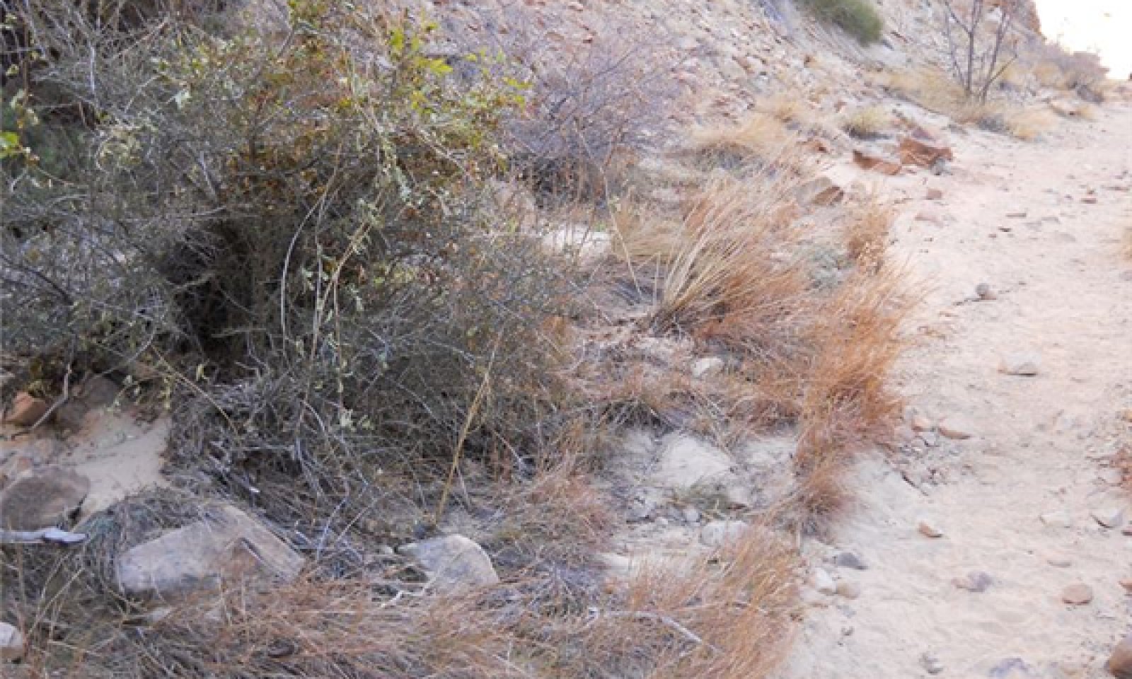
Figure 6. Typical view of the site.

Figure 7. Apache plume in the site.

Figure 8. The ecological site can be narrow in the canyon.

Figure 9. Mixed shrubs
This community phase is characterized by Apache plume, although a number of other species may exist in varying amounts throughout the site.
Figure 10. Annual production by plant type (representative values) or group (midpoint values)
Table 5. Annual production by plant type
Plant type Low
(lb/acre)Representative value
(lb/acre)High
(lb/acre)Shrub/Vine 150 300 400 Grass/Grasslike 100 150 225 Forb 25 45 60 Tree 0 5 15 Total 275 500 700 Table 6. Soil surface cover
Tree basal cover 0% Shrub/vine/liana basal cover 0% Grass/grasslike basal cover 0% Forb basal cover 0% Non-vascular plants 0% Biological crusts 0% Litter 10-20% Surface fragments >0.25" and <=3" 0-10% Surface fragments >3" 0-10% Bedrock 0-10% Water 0% Bare ground 0-70% Table 7. Canopy structure (% cover)
Height Above Ground (ft) Tree Shrub/Vine Grass/
GrasslikeForb <0.5 – 0-5% – 0-5% >0.5 <= 1 – 0-5% 0-15% 0-5% >1 <= 2 – 10-20% – – >2 <= 4.5 – 10-50% – – >4.5 <= 13 0-5% – – – >13 <= 40 – – – – >40 <= 80 – – – – >80 <= 120 – – – – >120 – – – – State 2
Current Potential StateThis state is similar to state 1 except that invasive species are present. The invasive species in this state are not dominant.
Community 2.1
Mixed Shrub and Exotic SpeciesThis community phase is characterized by Apache plume with some exotic species present. It is otherwise similar to community phase 1.1. The exotic species are not dominant on the site.
Transition 1
State 1 to 2Exotic species are present, but not dominant in the site.
Additional community tables
Table 8. Community 1.1 plant community composition
Group Common name Symbol Scientific name Annual production () Foliar cover (%) Grass/Grasslike1 Perennial grasses 100–225 Indian ricegrass ACHY Achnatherum hymenoides 10–150 – little bluestem SCSC Schizachyrium scoparium 10–150 – purple threeawn ARPU9 Aristida purpurea 0–75 – needle and thread HECO26 Hesperostipa comata 0–75 – James' galleta PLJA Pleuraphis jamesii 0–25 – Grass, perennial 2GP Grass, perennial 0–25 – sideoats grama BOCU Bouteloua curtipendula 0–25 – blue grama BOGR2 Bouteloua gracilis 0–25 – 2 Annual grass 0–15 Grass, annual 2GA Grass, annual 0–15 – Forb3 Perennial forbs 0–60 Forb, perennial 2FP Forb, perennial 0–25 – aster ASTER Aster 0–25 – milkvetch ASTRA Astragalus 0–15 – Wyoming Indian paintbrush CALI4 Castilleja linariifolia 0–15 – crispleaf buckwheat ERCO14 Eriogonum corymbosum 0–15 – beardtongue PENST Penstemon 0–5 – desert princesplume STPI Stanleya pinnata 0–5 – thistle CIRSI Cirsium 0–5 – 4 Annual forb 0–15 Forb, annual 2FA Forb, annual 0–15 – Shrub/Vine5 Vine 0–20 western white clematis CLLI2 Clematis ligusticifolia 0–20 – 6 Shrubs 150–400 Apache plume FAPA Fallugia paradoxa 50–400 – littleleaf mountain mahogany CEIN7 Cercocarpus intricatus 0–200 – Utah serviceberry AMUT Amelanchier utahensis 0–50 – Fremont's mahonia MAFR3 Mahonia fremontii 0–25 – roundleaf buffaloberry SHRO Shepherdia rotundifolia 0–25 – skunkbush sumac RHTR Rhus trilobata 0–15 – Stansbury cliffrose PUST Purshia stansburiana 0–10 – rubber rabbitbrush ERNA10 Ericameria nauseosa 0–10 – yellow rabbitbrush CHVI8 Chrysothamnus viscidiflorus 0–10 – singleleaf ash FRAN2 Fraxinus anomala 0–10 – threadleaf snakeweed GUMI Gutierrezia microcephala 0–5 – broom snakeweed GUSA2 Gutierrezia sarothrae 0–5 – mormon tea EPVI Ephedra viridis 0–5 – desert snowberry SYLO Symphoricarpos longiflorus 0–5 – Table 9. Community 1.1 forest overstory composition
Common name Symbol Scientific name Nativity Height ft Canopy cover (%) Diameter in Basal area (square ft/acre) TreeUtah juniper JUOS Juniperus osteosperma Native – 0-1 – 0 twoneedle pinyon PIED Pinus edulis Native – 0-1 – 0 Table 10. Community 2.1 plant community composition
Group Common name Symbol Scientific name Annual production () Foliar cover (%) Interpretations
Hydrological functions
Flash floods may occur in this site annually July through October
Recreational uses
Canyons in this region are typically used for hiking in throughout the year.
Supporting information
Type locality
Location 1: Wayne County, UT UTM zone N UTM northing 4235086 UTM easting 0481164 General legal description Grand Wash in Capitol Reef National Park. Other references
References
Coles, J., D. Clark, M. Dela Cruz, T. Clark, S. Topp, A. Evenden, A. Wight, G. Wakefield, and J. Von Loh. 2009. Vegetation classification and mapping project report, Capitol Reef National Park. Natural Resource Technical Report NPS/NCPN/NRTR—2009/187. National Park Service, Fort Collins, Colorado.
McWilliams, J. 2000. Fallugia paradoxa. In: Fire Effects Information System [Online]. U.S. Department of Agriculture, Forest Service, Rocky Mountain Research Station, Fire Sciences Laboratory (Producer). Available: http://www.fs.fed.us/database/feis/ [2013 April 08].
Woolley, R.R. 1946. Cloudburst floods in Utah 1850-1938. U.S. Geol. Surv. Water Supply Paper 994, 128p.
Other References
Bestelmeyer, B., J.R. Brown, K.M. Havstad, B. Alexander, G. Chavez, J.E. Herrick. 2003. Development and use of state and transition models for rangelands. J. Range Manage. 56(2):114-126.
Bestelmeyer, B.,A.J. Tugel, G.L. Peacock, D.G. Robinett, P.L. Shaver, J.R. Brown, J.E. Herrick, H. Sanchez, and K.M. Havstad. 2009. State-and-Transition Models for Heterogeneous Landscapes: A Strategy for Development and Application. Rangeland Ecology and Management 62:1-15.
Briske, D. D., S. D. Fuhlendorf, and F. E. Smeins. 2006. A Unified Framework for Assessment and Application of Ecological Thresholds. Rangeland Ecology and Management 59:225–236.
Briske, D. D., B. T. Bestelmeyer, T. K. Stringham, and P. L. Shaver. 2008. Recommendations for Development of Resilience-Based State-And-Transition Models. Rangeland Ecology and Management 61:359–367.
Herrick, J.E. J.W. Van Zee, K.M. Havstad, L.M. Burkett, and W.G. Whitford. 2005. Monitoring Manual for Grassland, Shrubland and Savanna Ecosystems. Volume I Quick Start. USDA - ARS Jornada Experimental Range, Las Cruces, New Mexico. Available at: http://usda-ars.nmsu.edu/monit_assess/monmanual_main.php.
Herrick, J.E. J.W. Van Zee, K.M. Havstad, L.M. Burkett, and W.G. Whitford. 2005. Monitoring Manual for Grassland, Shrubland and Savanna Ecosystems. Volume II: Design, Supplementary Methods and Interpretation. USDA - ARS Jornada Experimental Range, Las Cruces, New Mexico. Available at: http://usda-ars.nmsu.edu/monit_assess/monmanual_main.php.
Schoeneberger, P.J., D.A. Wysocki, E.C. Benham, and W.D. Broderson (editors). 2002. Field Book for Describing and Sampling Soils, Version 2.0. Natural Resources Conservation Service, National Soil Survey Center, Lincoln, NE.
Stringham, T.K., W.C. Krueger, and P.L. Shaver. 2003. State and Transition Modeling: An Ecological Process Approach. J. Range Manage 56: 106-113.
USDA, NRCS. 2008. (Electronic) Field Office Technical Guide. Available online at: http://efotg.nrcs.usda.gov/efotg_locator.aspx.
USDA, Natural Resource Conservation Service. 2004. National Forestry Handbook. Available online at: http://soils.usda.gov/technical/nfhandbook/
USDA, NRCS. 2007. The PLANTS Database. National Plant Data Center, Baton Rouge, LA 70874-4490 USA. Available online at: http://plants.usda.gov
USDA, NRCS. 2003. National Range and Pasture Handbook. Available online at: http://www.glti.nrcs.usda.gov/technical/publications/nrph.html
USDA, NRCS Soil Survey Manuals for appropriate counties within MLRA 35.Contributors
Sarah Quistberg
Rangeland health reference sheet
Interpreting Indicators of Rangeland Health is a qualitative assessment protocol used to determine ecosystem condition based on benchmark characteristics described in the Reference Sheet. A suite of 17 (or more) indicators are typically considered in an assessment. The ecological site(s) representative of an assessment location must be known prior to applying the protocol and must be verified based on soils and climate. Current plant community cannot be used to identify the ecological site.
Author(s)/participant(s) Contact for lead author Date Approved by Approval date Composition (Indicators 10 and 12) based on Annual Production Indicators
-
Number and extent of rills:
-
Presence of water flow patterns:
-
Number and height of erosional pedestals or terracettes:
-
Bare ground from Ecological Site Description or other studies (rock, litter, lichen, moss, plant canopy are not bare ground):
-
Number of gullies and erosion associated with gullies:
-
Extent of wind scoured, blowouts and/or depositional areas:
-
Amount of litter movement (describe size and distance expected to travel):
-
Soil surface (top few mm) resistance to erosion (stability values are averages - most sites will show a range of values):
-
Soil surface structure and SOM content (include type of structure and A-horizon color and thickness):
-
Effect of community phase composition (relative proportion of different functional groups) and spatial distribution on infiltration and runoff:
-
Presence and thickness of compaction layer (usually none; describe soil profile features which may be mistaken for compaction on this site):
-
Functional/Structural Groups (list in order of descending dominance by above-ground annual-production or live foliar cover using symbols: >>, >, = to indicate much greater than, greater than, and equal to):
Dominant:
Sub-dominant:
Other:
Additional:
-
Amount of plant mortality and decadence (include which functional groups are expected to show mortality or decadence):
-
Average percent litter cover (%) and depth ( in):
-
Expected annual annual-production (this is TOTAL above-ground annual-production, not just forage annual-production):
-
Potential invasive (including noxious) species (native and non-native). List species which BOTH characterize degraded states and have the potential to become a dominant or co-dominant species on the ecological site if their future establishment and growth is not actively controlled by management interventions. Species that become dominant for only one to several years (e.g., short-term response to drought or wildfire) are not invasive plants. Note that unlike other indicators, we are describing what is NOT expected in the reference state for the ecological site:
-
Perennial plant reproductive capability:
Print Options
Sections
Font
AAAAOther
PrintThe Ecosystem Dynamics Interpretive Tool is an information system framework developed by the USDA-ARS Jornada Experimental Range, USDA Natural Resources Conservation Service, and New Mexico State University.
Accessibility statement