Natural Resources
Conservation Service
Ecological site R035XY029UT
Colorado Plateau Riparian Complex (Valley Type IV - F1/G1 Stream Types)
Accessed: 07/09/2026
-
Search


Major Land Resource Area or ecological site by name and/or ID.
PreviousSectionsNextGeneral information
Draft. A draft ecological site description is either incomplete or has not undergone quality control and quality assurance review.
MLRA notes
Major Land Resource Area (MLRA): 035X–Colorado Plateau
This site is in narrow canyons. The streams within this site may go from canyon wall to canyon wall, leaving no riparian floodplain development. There are also small areas when the canyon bottom is wide enough to allow for some floodplain development and riparian vegetation establishment. In narrow canyons there may not be room to meander and deposit sediment on an annual cycle. Large floods moving through the canyon scour sediment and any vegetation that can establish. The associated plant communities are generally found on flood plains in small patches. Unvegetated sand bars are common throughout the site.
Associated sites
R035XY015UT Sandy Bottom
This site typically occurs on stream terraces above and below stream in a more open canyon setting.
Table 1. Dominant plant species
Tree Not specified
Shrub Not specified
Herbaceous Not specified
Physiographic features
This ecological site occurs in narrow canyons. This site is located in the Canyon Lands sections of the Colorado Plateau province of the Intermontane Plateaus. This site is characterized by narrow canyons and restricted riparian complex development. This site occurs on flood plains.
Table 2. Representative physiographic features
Landforms (1) Flood plain
Flooding duration Very brief (4 to 48 hours) to brief (2 to 7 days) Flooding frequency Frequent to occasional Ponding frequency None Elevation 3900 – 4600 ft Slope 2 – 15 % Water table depth 4 – 8 in Climatic features
The climate is characterized by hot summers and cool to warm winters, which can be slightly modified by local topographic conditions, such as aspect. Large fluctuations in daily temperatures are common. Precipitation is variable from month to month and year to year, but averages between 7 and 10 inches. Most of the precipitation comes as rain march through October. On average, July through October are the wettest months. Much of the summer precipitation occurs as convective thunderstorms.
Table 3 Representative climatic features
Frost-free period (average) 200 days Freeze-free period (average) 230 days Precipitation total (average) 10 in BarLineFigure 1. Monthly precipitation range
BarLineFigure 2. Monthly average minimum and maximum temperature
">Influencing water features
This site is a perennial fluvial system with bedrock influence at an average depth of 60 inches. The streams within this site are generally wide and shallow, although deep pools may exist intermittently. Water chemistry is neutral and non-saline (fresh).<br />
<br />
Valley Type(s): Valley Type IV consists of canyons and gorges with gentle elevation relief and valley floor gradients. This valley type is generally structurally controlled and incised in highly weathered material. Alluvial sediments occupy the valley floor. Sediment supply is generally moderate to high. This site is controlled laterally by the canyon walls and the stream bed is bedrock controlled throughout the site.<br />
Reference Stream Type The F4 stream type is entrenched and deeply incised. This stream type generally has slopes that are less than 2%, exhibit riffle/pool features and width to depth ratios that are high to very high. Stream banks may be non-existent in this site because the stream is as wide as the canyon bottom. Where stream banks do occur, they are typically sandy.<br />
<br />
Channel Material(s): Gravel (streambed) and bedrock (streambank) or sand (streambank)<br />
Stream Succession Scenario: F4<br />
Channel Evolution Stage: I<br />
Delineative Criteria: Low, High<br />
Entrenchment Ratio (floodprone width/bankfull width): 1, 1.4<br />
Width/Depth Ratio (bankfull width/bankfull depth at riffle)2/ 12 84<br />
Sinuosity (stream length/valley length): 1.5, 2.0<br />
Slope Range: 0.0001, 0.02<br />
Channel Materials D50 (particle size index, mm): 0.50, 1.0<br />
Channel Materials D84 (particle size index, mm): 12, 16Soil features
Soils on this site are alluvium derived from sandstone. They are typically loamy or fine sandy loam. Depth to indurated, unfractured sandstone bedrock is 20 to 60 inches.
Table 4. Representative soil features
Parent material (1) Alluvium – sandstone
Surface texture (1) Loam
(2) Fine sandy loam
Drainage class Somewhat poorly drained Soil depth 20 – 60 in Surface fragment cover <=3" 0 – 5 % Surface fragment cover >3" 0 – 5 % Available water capacity
(0-40in)4.2 – 0 in Calcium carbonate equivalent
(0-40in)0 – 5 % Electrical conductivity
(0-40in)0 – 2 mmhos/cm Sodium adsorption ratio
(0-40in)Not specified Soil reaction (1:1 water)
(0-40in)6.6 – 7.8 Subsurface fragment volume <=3"
(Depth not specified)0 – 5 % Subsurface fragment volume >3"
(Depth not specified)0 – 5 % Ecological dynamics
This riparian complex ecological site is characterized by a low gradient, wide river channel with a gravelly/sandy bottom and sandy to bedrock stream banks. This site flows through narrow canyons where the river may stretch from sandstone cliff to sandstone cliff. Where the canyon widens, there is limited riparian vegetation development. This site is subject to flash floods July through October. These flash floods may scour any sediment or vegetation that has established since the last flood event. The channel is typically wide and shallow and unvegetated banks are common.
The channel evolution model is simple in this site because it is restricted by the narrow canyon walls and bedrock under the stream bed. The stream is typically a F4 channel with no other potential reference channels or other states.
This site is characterized by narrow canyons with perennial streams and patchy riparian vegetation. High flow in the channel typically occurs with summer convective storms that can produce flash floods through the canyons. There is very little riparian vegetation associated with this site because of the narrow canyon bottom and flash floods that scour vegetation on a fairly regular cycle.
This riparian complex only contains floodplains and these do not occur continuously throughout the site. The vegetation is a mix of species that only establish between flood events in areas that are wide enough for sediment deposition. There can be a relatively high cover of coyote willow and cottonwood seedlings close to the channel. Mature cottonwoods do not occur often and are typically on terraces that are rarely influenced by the stream channel. The most common riparian species are horsetail, spike rush, Baltic rush, coyote willow and Fremont cottonwood.State and transition model
Custom diagramStandard diagram
Figure 3. State and Transition Model R035XY029UT
More interactive model formats are also available. View Interactive Models
More interactive model formats are also available. View Interactive Models
Click on state and transition labels to scroll to the respective textEcosystem states
State 1 submodel, plant communities
State 1
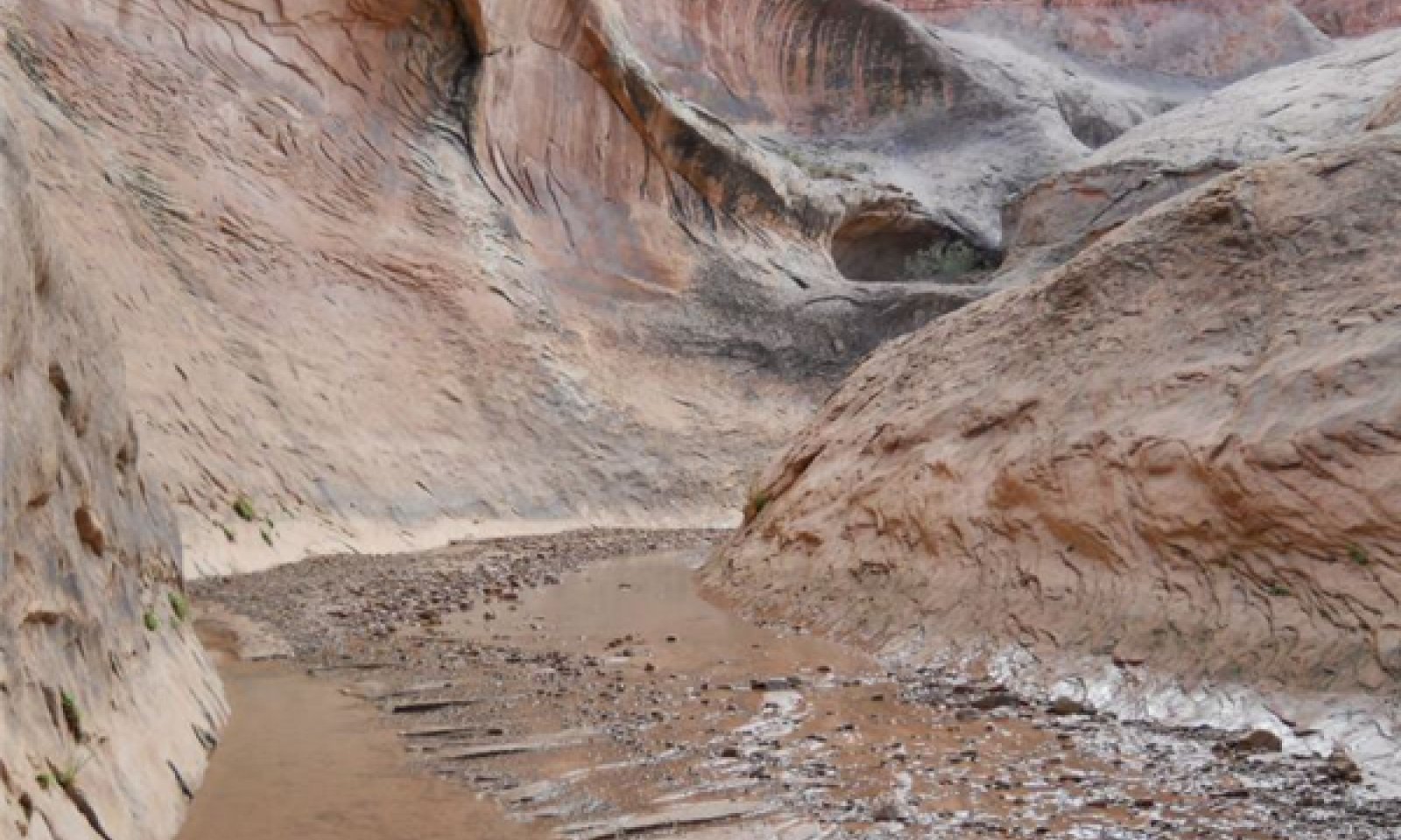
Reference ChannelThe only channel associated with this site is F4 stream type. There is only one state and one phase associated with this site because of the narrow canyon bottom and bedrock control of the stream bed. The stream is wide and shallow, making riparian vegetation sparse to absent along much of the site. Riparian vegetation does establish along some sections of the stream where the valley widens and floodplains can form. Vegetation is patchy throughout the site.
Community 1.1
F4 Channel
Figure 4. Channel with no plant community components

Figure 5. Channel with one plant community component on one

Figure 6. Cobbly/sandy stream bed

Figure 7. Patchy vegetation

Figure 8. Channel be is the width of the canyon bottom.

Figure 9. Bare stream banks
This phase represents the only potential channel type and vegetation associated with this site. The perennial stream is typically wide and shallow, although deep pools can exist throughout the site. There is no regular or repeating pattern of riparian vegetation, establishment is based on the flood recurrence interval. Vegetation at this site can easily be scoured by summer flash floods that can occur several times July through October.
Figure 10. Annual production by plant type (representative values) or group (midpoint values)
Table 5. Annual production by plant type
Plant type Low
(lb/acre)Representative value
(lb/acre)High
(lb/acre)Grass/Grasslike 0 50 100 Shrub/Vine 0 50 100 Forb 0 10 20 Total 0 110 220 Additional community tables
Table 6. Community 1.1 plant community composition
Group Common name Symbol Scientific name Annual production () Foliar cover (%) Grass/Grasslike1 Grasslike 0–100 common spikerush ELPA3 Eleocharis palustris 0–50 – mountain rush JUARL Juncus arcticus ssp. littoralis 0–50 – Graminoid (grass or grass-like) 2GRAM Graminoid (grass or grass-like) 0–15 – Forb2 Perennial Forb 0–20 horsetail EQUIS Equisetum 0–20 – Forb, perennial 2FP Forb, perennial 0–15 – Shrub/Vine3 Shrub 0–100 narrowleaf willow SAEX Salix exigua 0–75 – Shrub (>.5m) 2SHRUB Shrub (>.5m) 0–15 – Table 7. Community 1.1 forest overstory composition
Common name Symbol Scientific name Nativity Height ft Canopy cover (%) Diameter in Basal area (square ft/acre) TreeFremont cottonwood POFR2 Populus fremontii Native – 0-2 – 0 Interpretations
Recreational uses
Hiking is typically the only recreation use within this site.
Supporting information
Other references
Bestelmeyer, B., J.R. Brown, K.M. Havstad, B. Alexander, G. Chavez, J.E. Herrick. 2003. Development and use of state and transition models for rangelands. J. Range Manage. 56(2):114-126.
Bestelmeyer, B.,A.J. Tugel, G.L. Peacock, D.G. Robinett, P.L. Shaver, J.R. Brown, J.E. Herrick, H. Sanchez, and K.M. Havstad. 2009. State-and-Transition Models for Heterogeneous Landscapes: A Strategy for Development and Application. Rangeland Ecology and Management 62:1-15.
Briske, D. D., S. D. Fuhlendorf, and F. E. Smeins. 2006. A Unified Framework for Assessment and Application of Ecological Thresholds. Rangeland Ecology and Management 59:225–236.
Briske, D. D., B. T. Bestelmeyer, T. K. Stringham, and P. L. Shaver. 2008. Recommendations for Development of Resilience-Based State-And-Transition Models. Rangeland Ecology and Management 61:359–367.
Harrelson C. C., Rawlins, C. L. and Potyondy J. P. 1994. Stream Channel Reference Sites: An Illustrated Guide to Field Technique, General Technical Report RM-245, USDA - Forest Service, Rocky Mountain Forest and Range Experiment Station, Fort Collins, Colorado, 61 pages. Available at: http://www.stream.fs.fed.us/publications/documentsStream.html
Herrick, J.E. J.W. Van Zee, K.M. Havstad, L.M. Burkett, and W.G. Whitford. 2005. Monitoring Manual for Grassland, Shrubland and Savanna Ecosystems. Volume I Quick Start. USDA - ARS Jornada Experimental Range, Las Cruces, New Mexico. Available at: http://usda-ars.nmsu.edu/monit_assess/monmanual_main.php.
Herrick, J.E. J.W. Van Zee, K.M. Havstad, L.M. Burkett, and W.G. Whitford. 2005. Monitoring Manual for Grassland, Shrubland and Savanna Ecosystems. Volume II: Design, Supplementary Methods and Interpretation. USDA - ARS Jornada Experimental Range, Las Cruces, New Mexico. Available at: http://usda-ars.nmsu.edu/monit_assess/monmanual_main.php.
Kovalchik, B.L. and L.A. Chitwood, 1990. Use of Geomorphology in the Classification of Riparian Plant Associations in Mountainous Landscapes of Central Oregon, U.S.A. Forest Ecology and Management 33/34:405-418.
Poole, G.C. and C.H. Berman, 2001. An Ecological Perspective on In-Stream Temperature: Natural Heat Dynamics and Mechanisms of Human-Caused Thermal Degradation. Environmental Management 27:787-802.
Pringle, C.M., R.J. Naiman, G. Bretschko, J. R. Karr, M.W. Osgood, J.R. Webster, R.L. Welcomme, and M.J. Winterbourn. 1988. Patch Dynamics in Lotic Systems: the Stream as Mosaic. The North American Benthological Society 7(4):503-524.
Rosgen, D.L., 1994. A Stream Classification System. Catena, 22 169199. Elsevier Science, Amsterdam.
Rosgen, D.L., 1996. Applied River Morphology. Wildland Hydrology Books, Pagosa Springs, Colorado, and Ft. Collins, CO.
Rosgen, D.L., 2006. A Watershed Assessment for River Stability and Sediment Supply (WARSSS). Wildland Hydrology Books, Fort Collins, CO.
Schoeneberger, P.J., D.A. Wysocki, E.C. Benham, and W.D. Broderson (editors). 2002. Field Book for Describing and Sampling Soils, Version 2.0. Natural Resources Conservation Service, National Soil Survey Center, Lincoln, NE.
Stringham, T.K., W.C. Krueger, and P.L. Shaver. 2003. State and Transition Modeling: An Ecological Process Approach. J. Range Manage 56: 106-113.
USDA, NRCS. 2008. (Electronic) Field Office Technical Guide. Available online at: http://efotg.nrcs.usda.gov/efotg_locator.aspx.
USDA, Natural Resource Conservation Service. 2004. National Forestry Handbook. Available online at: http://soils.usda.gov/technical/nfhandbook/
USDA, NRCS. 2007. The PLANTS Database. National Plant Data Center, Baton Rouge, LA 70874-4490 USA. Available online at: http://plants.usda.govContributors
Sarah Quistberg
Rangeland health reference sheet
Interpreting Indicators of Rangeland Health is a qualitative assessment protocol used to determine ecosystem condition based on benchmark characteristics described in the Reference Sheet. A suite of 17 (or more) indicators are typically considered in an assessment. The ecological site(s) representative of an assessment location must be known prior to applying the protocol and must be verified based on soils and climate. Current plant community cannot be used to identify the ecological site.
Author(s)/participant(s) Contact for lead author Date Approved by Approval date Composition (Indicators 10 and 12) based on Annual Production Indicators
-
Number and extent of rills:
-
Presence of water flow patterns:
-
Number and height of erosional pedestals or terracettes:
-
Bare ground from Ecological Site Description or other studies (rock, litter, lichen, moss, plant canopy are not bare ground):
-
Number of gullies and erosion associated with gullies:
-
Extent of wind scoured, blowouts and/or depositional areas:
-
Amount of litter movement (describe size and distance expected to travel):
-
Soil surface (top few mm) resistance to erosion (stability values are averages - most sites will show a range of values):
-
Soil surface structure and SOM content (include type of structure and A-horizon color and thickness):
-
Effect of community phase composition (relative proportion of different functional groups) and spatial distribution on infiltration and runoff:
-
Presence and thickness of compaction layer (usually none; describe soil profile features which may be mistaken for compaction on this site):
-
Functional/Structural Groups (list in order of descending dominance by above-ground annual-production or live foliar cover using symbols: >>, >, = to indicate much greater than, greater than, and equal to):
Dominant:
Sub-dominant:
Other:
Additional:
-
Amount of plant mortality and decadence (include which functional groups are expected to show mortality or decadence):
-
Average percent litter cover (%) and depth ( in):
-
Expected annual annual-production (this is TOTAL above-ground annual-production, not just forage annual-production):
-
Potential invasive (including noxious) species (native and non-native). List species which BOTH characterize degraded states and have the potential to become a dominant or co-dominant species on the ecological site if their future establishment and growth is not actively controlled by management interventions. Species that become dominant for only one to several years (e.g., short-term response to drought or wildfire) are not invasive plants. Note that unlike other indicators, we are describing what is NOT expected in the reference state for the ecological site:
-
Perennial plant reproductive capability:
Print Options
Sections
Font
AAAAOther
PrintThe Ecosystem Dynamics Interpretive Tool is an information system framework developed by the USDA-ARS Jornada Experimental Range, USDA Natural Resources Conservation Service, and New Mexico State University.
Accessibility statement