Natural Resources
Conservation Service
Ecological site R035XY019UT
Shallow Sand Rock Pocket (Utah Juniper/Two-Needle Pinyon)
Accessed: 06/26/2026
-
Search


Major Land Resource Area or ecological site by name and/or ID.
PreviousSectionsNextGeneral information
Provisional. A provisional ecological site description has undergone quality control and quality assurance review. It contains a working state and transition model and enough information to identify the ecological site.
Click to explore map
Figure 1. Mapped extent
Areas shown in blue indicate the maximum mapped extent of this ecological site. Other ecological sites likely occur within the highlighted areas. It is also possible for this ecological site to occur outside of highlighted areas if detailed soil survey has not been completed or recently updated.
MLRA notes
Major Land Resource Area (MLRA): 035X–Colorado Plateau
This ecological site occurs in the northern portion of MLRA 35, Colorado Plateau Province. It is found principally in the Canyon Lands and High Plateaus of Utah sections within that MLRA. This area has been stucturally uplifted over time while rivers flowing across it were cutting down into it's bedrock. Areas of shale, sandstone, limestone, dolomite, and volcanic rock outcrop are found throughout the region. In most areas elevation is 4,250 to 4,950 feet but can range from 8,000 to over 10,000 feet on mountains located within the MLRA.
Associated sites
R035XY233UT Semidesert Shallow Sandy Loam (Blackbrush)
R035XY236UT Semidesert Shallow Sandy Loam (Utah Juniper, Blackbrush)
Table 1. Dominant plant species
Tree (1) Juniperus osteosperma
(2) Pinus edulisShrub (1) Coleogyne ramosissima
(2) Fraxinus anomalaHerbaceous (1) Achnatherum hymenoides
(2) Pleuraphis jamesiiPhysiographic features
This site is found principally on structural benches and mesas. It also occurs on sand sheets associated with the dip slope portion of cuestas, and directly on cuestas. It can sometimes be found on both broad and narrow ledges and hillslopes found on scarp slope cuestas. Runoff is medium to very high. Slopes typically range from 2-15%. Elevations are generally 3960-5560.
Table 2. Representative physiographic features
Landforms (1) Structural bench
(2) Mesa
(3) Dune
Flooding frequency None Elevation 3960 – 5560 ft Slope 2 – 15 % Aspect Aspect is not a significant factor Climatic features
The climate is characterized by hot, dry summers, cold winters and moist springs. Climate is often modified by local topographic conditions. For example, cliff faces can appreciably modify both precipitation and temperature patterns. March, April and July through October are the wettest months of the year with May, June and November through February being the driest. Approximately 65 to 70% of the precipitation occurs as rain from May through October. Precipitation is extremely variable from month to month and from year to year but averages between 6-9 inches. Large fluctuations in daily temperatures are common.
Table 3 Representative climatic features
Frost-free period (average) 190 days Freeze-free period (average) 220 days Precipitation total (average) 10 in BarLineFigure 2. Monthly precipitation range
BarLineFigure 3. Monthly average minimum and maximum temperature
">Influencing water features
There are no influencing water features in this site.
Soil features
This site occurs on eolian deposits derived from sandstone parent material. The sands are deposited and stabilized in the depressions of undulating exposed bedrock and/or in shallow areas and can be mixed with some colluvium. Soil surfaces typically support biological crusts, but areas of bare sand or surface gravels are common. Plants are concentrated where the soil and available moisture are most conducive to plant growth. The soils are typically psamments. There are no distinguishing soil development characteristics; they are often composed of unconsolidated sand of various depths. The sand accumulates and is stabilized by vegetation or crust. Water often runs onto the soil from adjacent rock outcrop and may pool. When there is a large erosion event, soils will sometimes move and redeposit in nearby areas. Soil color is typically yellowish, and textures range from loamy to fine sand and may contrain gravel. Available water holding capacity is 0.2 to 2.2 inches.
This site has been used in the following soil surveys and has been correlated to the following components:
UT685 - Capitol Reef - Nalcase, Parkwash;
UT687 – Arches National Park – Arches; Mident Family; Moclom Family; Nalcase; Rizno; Santrick
UT688 – Canyonlands National Monument – Arches, Needles
Table 4. Representative soil features
Parent material (1) Eolian deposits – sandstone
(2) Alluvium – sandstone
Surface texture (1) Fine sand
(2) Loamy fine sand
(3) Loamy sand
Family particle size (1) Sandy
Drainage class Well drained to excessively drained Permeability class Rapid to very rapid Soil depth 4 – 20 in Surface fragment cover <=3" 0 – 5 % Surface fragment cover >3" Not specified Available water capacity
(0-40in)0.2 – 2.2 in Calcium carbonate equivalent
(0-40in)0 – 5 % Electrical conductivity
(0-40in)0 – 2 mmhos/cm Sodium adsorption ratio
(0-40in)Not specified Soil reaction (1:1 water)
(0-40in)7.4 – 8.4 Subsurface fragment volume <=3"
(Depth not specified)0 – 5 % Subsurface fragment volume >3"
(Depth not specified)0 – 5 % Ecological dynamics
This ecological site occurs on shallow sand pockets in rock outcrop found in Major Land Resource Area (MLRA) D35—The Colorado Plateau. This site will only occur when this rock outcrop makes up the majority of the area. This site receives extra moisture in the form of run-on from the surrounding rock outcroppings. The amount of this extra moisture, (i.e., size of the surrounding rock outcrop watershed) allows for the presence of a wide variety of perennial grasses, forbs and shrubs, and in some cases, higher than expected production. Cheatgrass is not readily invading many of these sites. Widespread fire is not an influencing factor in this community due to natural fire barriers in the form of rock outcrop. On rare occasions, fire impact has been observed from lightening caused spot fires which are small in nature but that can cause the understory to shift from one dominated by shrubs to one with a more herbaceous aspect.
Two distinct phases of this reference community have been characterized in this report, one dominated by various shrub species in the understory and one dominated by perennial grasses.
The first and most prominent, is the Shrub Phase. This phase of the ecological site is characterized by an overstory of old Utah juniper and Two-needle pinyon. A shrub layer dominates the understory with Blackbrush, Littleleaf mahogany, Singleleaf ash, and Mexican cliffrose commonly found. Herbaceous species make up less than 10 percent of the understory. Blackbrush is thought to act as an paleo-endemic species on this site, and once removed, may not recover. Important understory species include Indian ricegrass and James galleta. The appearance of most forbs is episodic in nature and is closely tied to precipitation events.
The Herbaceous Phase is characterized significantly less shrub production in the understory while the perennial grasses and other herbaceous species are more dominant, and at times, gives the site a grassland appearance.
This variation appears to be a natural part of this ecological site. Factors such as pocket size, potenial moisture run-on amounts, soil depth, slope, aspect and many other elements combine to create unique combinations of species composition and production at any given location. The reference state is self sustaining and resistant to change due to its high resistance to natural disturbances and high resilience following natural disturbances.
The following diagram describes some of the most commonly occurring communities found on this ecological site. It does not necessarily depict all the vegetative states, phases, pathways and transitions associated with it. As more data are collected, some of these plant communities may be revised or removed, and new ones may be added. This model was developed using range data collected over the last 30 years in MLRA D35 in southeastern Utah. Both ocular and measured data was collected and utilized.State and transition model
Custom diagramStandard diagram
More interactive model formats are also available. View Interactive Models
More interactive model formats are also available. View Interactive Models
Click on state and transition labels to scroll to the respective textState 1 submodel, plant communities
State 2 submodel, plant communities
State 3 submodel, plant communities
State 1
Reference StateThe reference state was determined by study of rangeland relic areas, areas protected from excessive disturbance, and areas under land use influences, such as grazing and recreation. Literature reviews, trends in plant community dynamics, and historical accounts are also considered.
The reference state represents the historic plant communities and natural ecological dynamics of the Shallow Sand Rock Pocket, Utah juniper/Two-needle pinyon site. This state includes the biotic communities that become established on the ecological site if all successional sequences are completed under current climatic conditions; natural disturbances are inherent in its development. This state is dominated by an overstory of Utah juniper and Two-needle pinyon, and a mixture of shrubs with shadscale, blackbrush and littleleaf mahogany being the most common. Perennial cool season grasses may also not be present depending on soil development. The primary disturbance mechanism is weather fluctuations. The reference state is self sustaining and resistant to change due to high resistance to natural disturbances and high resilience following natural disturbances. When natural disturbances occur, the rate of recovery is relatively rapid due to niches being filled with highly adapted native vegetation.
Reference State: Community phases disturbed by climate fluctuations.
Indicators: A site dominated by various shrub species , where James galleta and Indian ricegrass and sand dropseed may also be present.
Feedbacks: Extended drought resulting in a reduction of native perennial plant vigor. Normal fluctuations in weather allowing for the maintenance of both shrubs and perennial grasses.
At-risk Community Phase: All communities are at risk when nutrients are available for invasive plants to establish. Plant community 1.1 is especially at risk due to limited production and cover of understory grasses.
Trigger: Introduction of invasive plants to fill available niches.Community 1.1
Utah juniper, Two-needle pinyon, Shrub Phase
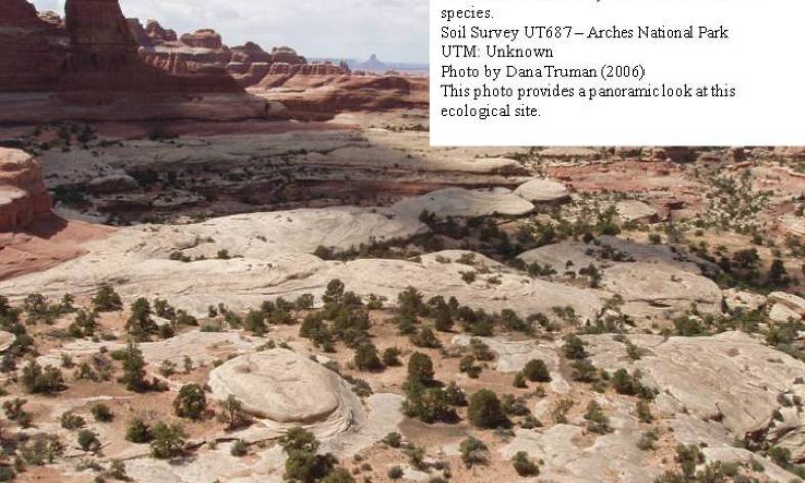
Figure 4. Panoramic View

Figure 5. 1.1 Shrub Phase.
This phase of the ecological site is characterized by an overstory of old Utah juniper and Two-needle pinyon. A shrub layer dominates the understory with Blackbrush, with Littleleaf mahogany, Singleleaf ash and Mexican cliffrose commonly occurring. Herbaceous species make up less than 10 percent of the understory. Important understory species include Indian ricegrass and James galleta. The appearance of most forbs is episodic in nature and is closely tied to precipitation events. Other commonly occurring herbaceous species include Needleandthread, and Sixweeks fescue.
Air dry weight is approximately 5-10 percent forbs, 5-10 percent grasses, 40-70 percent shrubs, and15-40 percent trees. Bare ground is variable (2-55%) depending on biological crust cover, which is also variable (0-64%) and surface rock fragments (0-20%).
The following tables present a typical example of the vegetative floristics of a community phase 1.1 plant community.Figure 6. Annual production by plant type (representative values) or group (midpoint values)
Table 5. Annual production by plant type
Plant type Low
(lb/acre)Representative value
(lb/acre)High
(lb/acre)Shrub/Vine 80 180 250 Tree 17 60 100 Grass/Grasslike 15 35 50 Forb 20 30 40 Total 132 305 440 Table 6. Ground cover
Tree foliar cover 0-30% Shrub/vine/liana foliar cover 10-40% Grass/grasslike foliar cover 0-20% Forb foliar cover 0-10% Non-vascular plants 0% Biological crusts 0-60% Litter 0-20% Surface fragments >0.25" and <=3" 0-20% Surface fragments >3" 0-10% Bedrock 0-20% Water 0% Bare ground 0-60% Table 7. Canopy structure (% cover)
Height Above Ground (ft) Tree Shrub/Vine Grass/
GrasslikeForb <0.5 – 0-5% 0-10% 0-10% >0.5 <= 1 – 0-10% 0-5% 0-5% >1 <= 2 – 5-10% 0-5% 0-5% >2 <= 4.5 – 5-20% – – >4.5 <= 13 0-15% – – – >13 <= 40 5-30% – – – >40 <= 80 – – – – >80 <= 120 – – – – >120 – – – – Community 1.2
Utah juniper, Two-needle pinyon, Herbaceous Phase
Figure 7. 1.2 herbaceous

This phase of the ecological site is characterized by an overstory of old Utah juniper and Two-needle pinyon. The shrub layer makes up < 20 percent of the understory. Blackbrush, with Littleleaf mahogany, Singleleaf ash and Mexican cliffrose commonly occur. Herbaceous species make up the majority of the understory production. Important understory species include Indian ricegrass and James galleta. Other commonly occurring herbaceous species include Needleandthread, and Sixweeks fescue. The appearance of most forbs is episodic in nature and is closely tied to precipitation events.
Air dry weight is approximately 5-10 percent forbs, 20-50 percent grasses, 15-20 percent shrubs, and15-40 percent trees. Bare ground is variable (2-55%) depending on biological crust cover, which is also variable (0-64%) and surface rock fragments (0-20%).
The tables described for the community phase 1.1 site also provide for a typical example of the vegetative floristics of a community phase 1.2 plant community.Pathway 1.1a
Community 1.1 to 1.2
Utah juniper, Two-needle pinyon, Shrub Phase
Utah juniper, Two-needle pinyon, Herbaceous PhaseThis pathway describes the affects of any combination of surface spot fire activity, heavy wildlife browsing, and insects or pathogens that kill the woody species, followed by sufficient run-on moisture to allow herbaceous species to dominate the understory.
Pathway 1.2a
Community 1.2 to 1.1
Utah juniper, Two-needle pinyon, Herbaceous Phase
Utah juniper, Two-needle pinyon, Shrub PhaseThis pathway describes the affects of a long term lack of disturbances that kill woody vegetation combined with either drought or a natural physiographic alteration that does not allow for sufficient run-on moisture to support herbaceous species.
State 2
Current Potential StateThis current potential state is composed of the same two community phases described in the Reference State. Community phase 1.1 describes the "shrub dominated" aspect while Community phase 1.2 describes the more "herbaceous" aspect. Non-native and/or Invasive species now occupy these communities. Management needs to recognize and account for these species. A transitional threshold has been crossed and a return to the Reference State is not feasible.
Reference State: Community phases disturbed by climate fluctuations.
Indicators: A site dominated by various shrub species , where James galleta and Indian ricegrass and sand dropseed may also be present. Non-native species are now present in the stand.
Feedbacks: Extended drought resulting in a reduction of native perennial plant vigor. Normal fluctuations in weather allowing for the maintenance of both shrubs and perennial grasses.
At-risk Community Phase: All communities are at risk when nutrients are available for invasive plants to establish. Plant community 1.1 is especially at risk due to limited production and cover of understory grasses.
Trigger: Spread of invasive plants to fill available niches.Community 2.1
Utah juniper, Two-needle pinyon, shrub, invasive weed Phase
Figure 8. 2.1 Invasive Weed Phase.
This phase of the ecological site is characterized by an overstory of old Utah juniper and two-needle pinyon. A shrub layer dominates the understory with Blackbrush, with Littleleaf mahogany, Singleleaf ash and Mexican cliffrose commonly occurring. Herbaceous species make up less than 10 percent of the understory. Important understory species include Indian ricegrass and James galleta. Other commonly occurring herbaceous species include Needleandthread, and Sixweeks fescue. The appearance of most forbs is episodic in nature and is closely tied to precipitation events. Invasive species such as Cheatgrass and Russian thistle are present.
Air dry weight is approximately 5-10 percent forbs, 5-10 percent grasses, 40-70 percent shrubs, and 15-40 percent trees. Bare ground is variable (2-55%) depending on biological crust cover, which is also variable (0-64%) and surface rock fragments (0-20%).
The following tables present a typical example of the vegetative floristics of a community phase 2.1 plant community.Figure 9. Annual production by plant type (representative values) or group (midpoint values)
Table 8. Annual production by plant type
Plant type Low
(lb/acre)Representative value
(lb/acre)High
(lb/acre)Shrub/Vine 80 180 250 Tree 17 60 100 Grass/Grasslike 15 35 50 Forb 20 30 40 Total 132 305 440 Table 9. Ground cover
Tree foliar cover 0-30% Shrub/vine/liana foliar cover 10-40% Grass/grasslike foliar cover 0-20% Forb foliar cover 0-10% Non-vascular plants 0% Biological crusts 0-60% Litter 0-20% Surface fragments >0.25" and <=3" 0-20% Surface fragments >3" 0-10% Bedrock 0-20% Water 0% Bare ground 0-60% Table 10. Canopy structure (% cover)
Height Above Ground (ft) Tree Shrub/Vine Grass/
GrasslikeForb <0.5 – 0-5% 0-10% 0-10% >0.5 <= 1 – 0-10% 0-5% 0-5% >1 <= 2 – 5-10% 0-5% 0-5% >2 <= 4.5 – 5-20% – – >4.5 <= 13 0-15% – – – >13 <= 40 5-30% – – – >40 <= 80 – – – – >80 <= 120 – – – – >120 – – – – Community 2.2
Utah juniper, Two-needle pinyon, Herbaceous, Invasive weeds.
Figure 10. 2.2 Herbaceous, Invasive Weed Phase.
This phase of the ecological site is characterized by an overstory of old Utah juniper (JUOS) and Two-needle pinyon. The shrub layer makes up < 20 percent of the understory. Blackbrush, with Littleleaf mahogany, Singleleaf ash and Mexican cliffrose commonly occur. Herbaceous species make up the majority of the understory production. Important understory species include Indian ricegrass and James galleta. Other commonly occurring herbaceous species include Needleandthread, and Sixweeks fescue. Non-native and invasive species now occupy the site. The appearance of most forbs is episodic in nature and is closely tied to precipitation events.
Air dry weight is approximately 5-10 percent forbs, 20-50 percent grasses, 15-20 percent shrubs, and15-40 percent trees. Bare ground is variable (2-55%) depending on biological crust cover, which is also variable (0-64%) and surface rock fragments (0-20%).
The tables described for the community phase 2.1 site also provide for a typical example of the vegetative floristics of a community phase 2.2 plant community.Pathway 2.1
Community 2.1 to 2.2
Utah juniper, Two-needle pinyon, shrub, invasive weed Phase
Utah juniper, Two-needle pinyon, Herbaceous, Invasive weeds.This pathway describes the affects of any combination of surface spot fire activity, heavy wildlife browsing, and insects or pathogens that kill the woody species, followed by sufficient run-on moisture to allow herbaceous species to dominate the understory. Invasive species present may increase the potential impact of fire.
Pathway 2.2A
Community 2.2 to 2.1
Utah juniper, Two-needle pinyon, Herbaceous, Invasive weeds.
Utah juniper, Two-needle pinyon, shrub, invasive weed PhaseThis pathway describes the affects of a long term lack of disturbances that kill woody vegetation combined with either drought or a natural physiographic alteration that does not allow for sufficient run-on moisture to support herbaceous species.
State 3
Eroded Understory StateThis phase of the ecological site is characterized by an overstory of old Utah juniper and Two-needle pinyon. Shrubs may or may not be present in the understory. Where present that are usually widely scattered. Blackbrush, Littleleaf mahogany, Singleleaf ash and Mexican cliffrose commonly occur. Perennial grasses and forbs are mostly missing. Cheatgrass, Red brome, and Russian thistle may be present. The appearance of most forbs is episodic in nature and is closely tied to precipitation events.
Community 3.1
Utah Juniper, Two-needle pinyon, Eroded Phase
Figure 11. 3.1 Eroded Phase.
This community phase is characterized by old Utah Juniper and Two-needle pinyon in the understory. Understory vegetation is significently reduced or missing in the understory. Invasive species such as Cheatgrass and Russian thistle may or may not be present. Cryptogamic crust where present may be holding the soil in place. As this biological crust is reduced, the soil takes on a "dimpled look". As deteration continues, soils lose structure and become loose sand.
Transition T1A
State 1 to 2This pathway describes the affects of the presence of a seed source of invasive and/or non-native species that become established by any combination of surface spot fire activity, drought, and improper livestock grazing. A threshold is passed when invasive and/or non-native species become established.
Transition T1B
State 1 to 3This pathway describes the affects of any combination of drought, improper livestock grazing, and heavy wildlife browsing that is sufficient to significantly reduce or eliminate native herbaceous understory species. Some annual invasive and/or non-native species may be present. A threshold is passed when native herbaceous species are significantly reduced and/or are not able to regenerate themselves.
Transition T2B
State 2 to 3This pathway describes the affects of any combination of drought, improper livestock grazing, and heavy wildlife browsing that is sufficient to significantly reduce or eliminate native herbaceous understory species. Annual invasive and/or non-native species may be present. A threshold is passed when native herbaceous species are significantly reduced and/or are not able to regenerate themselves.
Transition T2A
State 2 to 3This pathway describes the affects of any combination of surface spot fire activity, drought, heavy wildlife browsing and improper livestock grazing that allows the site to transition into a eroded state. A threshold is passed when invasive and/or non-native species dominate the community.
Additional community tables
Table 11. Community 1.1 plant community composition
Group Common name Symbol Scientific name Annual production () Foliar cover (%) Tree0 Trees 17–117 Utah juniper JUOS Juniperus osteosperma 10–110 – twoneedle pinyon PIED Pinus edulis 7–110 – Shrub/Vine0 Dominant Shrubs 50–180 Bigelow sage ARBI3 Artemisia bigelovii 0–120 – blackbrush CORA Coleogyne ramosissima 0–100 – singleleaf ash FRAN2 Fraxinus anomala 0–100 – littleleaf mountain mahogany CEIN7 Cercocarpus intricatus 0–75 – Stansbury cliffrose PUST Purshia stansburiana 0–45 – 3 Sub-Dominant Shrubs 50–200 Havard oak QUHA3 Quercus havardii 0–81 – sumac RHUS Rhus 0–65 – roundleaf buffaloberry SHRO Shepherdia rotundifolia 0–60 – broom snakeweed GUSA2 Gutierrezia sarothrae 0–50 – Utah serviceberry AMUT Amelanchier utahensis 0–45 – alderleaf mountain mahogany CEMO2 Cercocarpus montanus 0–40 – rubber rabbitbrush ERNA10 Ericameria nauseosa 0–40 – mormon tea EPVI Ephedra viridis 0–36 – fourwing saltbush ATCA2 Atriplex canescens 0–30 – Martin's ceanothus CEMA2 Ceanothus martinii 0–30 – brickellbush BRICK Brickellia 0–28 – crispleaf buckwheat ERCO14 Eriogonum corymbosum 0–28 – shadscale saltbush ATCO Atriplex confertifolia 0–25 – narrowleaf yucca YUAN2 Yucca angustissima 0–24 – Torrey's jointfir EPTO Ephedra torreyana 0–20 – Cutler's jointfir EPCU Ephedra cutleri 0–18 – Fremont's mahonia MAFR3 Mahonia fremontii 0–16 – plains pricklypear OPPO Opuntia polyacantha 0–13 – yucca YUCCA Yucca 0–9 – sand sagebrush ARFI2 Artemisia filifolia 0–9 – beechleaf frangula FRBE2 Frangula betulifolia 0–7 – Whipple's fishhook cactus SCWH Sclerocactus whipplei 0–4 – scarlet hedgehog cactus ECCOC Echinocereus coccineus var. coccineus 0–3 – Utah fendlerbush FEUT Fendlerella utahensis 0–1 – Grass/Grasslike0 Dominant Grass 15–70 Indian ricegrass ACHY Achnatherum hymenoides 10–55 – James' galleta PLJA Pleuraphis jamesii 5–45 – 1 Sub-Dominant Grass 20–50 New Mexico feathergrass HENE5 Hesperostipa neomexicana 0–50 – needle and thread HECOC8 Hesperostipa comata ssp. comata 0–40 – purple threeawn ARPU9 Aristida purpurea 0–40 – sixweeks fescue VUOC Vulpia octoflora 0–40 – sand dropseed SPCR Sporobolus cryptandrus 0–28 – spike dropseed SPCO4 Sporobolus contractus 0–12 – Grass, perennial 2GP Grass, perennial 0–10 – desert needlegrass ACSP12 Achnatherum speciosum 0–5 – saline wildrye LESAS Leymus salinus ssp. salinus 0–5 – bluegrass POA Poa 0–4 – Sandberg bluegrass POSE Poa secunda 0–4 – blue grama BOGR2 Bouteloua gracilis 0–2 – hairy woollygrass ERPI5 Erioneuron pilosum 0–1 – muttongrass POFE Poa fendleriana 0–1 – Forb2 20–50 pointed gumweed GRFA Grindelia fastigiata 0–45 – Jones' pepperweed LEMOJ Lepidium montanum var. jonesii 0–25 – Wright's bird's beak COWR2 Cordylanthus wrightii 0–25 – Forb, annual 2FA Forb, annual 0–20 – Forb, perennial 2FP Forb, perennial 0–20 – rock goldenrod PEPUP Petradoria pumila ssp. pumila 0–20 – cryptantha CRYPT Cryptantha 0–18 – Fendler's sandmat CHFE3 Chamaesyce fendleri 0–18 – gooseberryleaf globemallow SPGR2 Sphaeralcea grossulariifolia 0–16 – browneyed Susan RUTR2 Rudbeckia triloba 0–15 – woolly plantain PLPA2 Plantago patagonica 0–15 – fineleaf hymenopappus HYFI Hymenopappus filifolius 0–14 – tansymustard DESCU Descurainia 0–14 – Brenda's yellow cryptantha CRFL5 Cryptantha flava 0–12 – gilia GILIA Gilia 0–11 – Utah penstemon PEUT Penstemon utahensis 0–11 – longbeak streptanthella STLO4 Streptanthella longirostris 0–11 – ragwort SENEC Senecio 0–10 – hoary tansyaster MACA2 Machaeranthera canescens 0–9 – Newberry's twinpod PHNE5 Physaria newberryi 0–8 – desert princesplume STPI Stanleya pinnata 0–8 – tarragon ARDR4 Artemisia dracunculus 0–8 – winged buckwheat ERAL4 Eriogonum alatum 0–7 – Parry's sandmat CHPA28 Chamaesyce parryi 0–6 – dock RUMEX Rumex 0–6 – thrift mock goldenweed STARA Stenotus armerioides var. armerioides 0–6 – lobeleaf groundsel PAMU11 Packera multilobata 0–6 – beardtongue PENST Penstemon 0–5 – stickseed LAPPU Lappula 0–5 – Comb Wash buckwheat ERCL2 Eriogonum clavellatum 0–4 – woolly locoweed ASMO7 Astragalus mollissimus 0–4 – mustard BRASS2 Brassica 0–3 – desert trumpet ERIN4 Eriogonum inflatum 0–3 – buckwheat ERIOG Eriogonum 0–3 – bluestar AMSON Amsonia 0–3 – shy gilia GIIN2 Gilia inconspicua 0–3 – ipomopsis IPOMO2 Ipomopsis 0–3 – Townsend daisy TOWNS Townsendia 0–3 – Colorado four o'clock MIMU Mirabilis multiflora 0–2 – cleftleaf wildheliotrope PHCRC Phacelia crenulata var. corrugata 0–2 – phlox PHLOX Phlox 0–2 – narrowleaf stoneseed LIIN2 Lithospermum incisum 0–2 – northwestern Indian paintbrush CAAN7 Castilleja angustifolia 0–2 – milkweed ASCLE Asclepias 0–2 – onion ALLIU Allium 0–2 – madwort ALYSS Alyssum 0–1 – bastard toadflax COUM Comandra umbellata 0–1 – roughseed cryptantha CRFL6 Cryptantha flavoculata 0–1 – larkspur DELPH Delphinium 0–1 – hairy false goldenaster HEVI4 Heterotheca villosa 0–1 – bristle flax LIAR3 Linum aristatum 0–1 – wedgeleaf draba DRCU Draba cuneifolia 0–1 – Wetherill's buckwheat ERWE Eriogonum wetherillii 0–1 – hoary Townsend daisy TOIN Townsendia incana 0–1 – Table 12. Community 1.2 plant community composition
Group Common name Symbol Scientific name Annual production () Foliar cover (%) Table 13. Community 2.1 plant community composition
Group Common name Symbol Scientific name Annual production () Foliar cover (%) Tree0 Trees 17–117 Utah juniper JUOS Juniperus osteosperma 10–110 – twoneedle pinyon PIED Pinus edulis 7–110 – Shrub/Vine0 Dominant Shrubs 50–180 Bigelow sage ARBI3 Artemisia bigelovii 0–120 – blackbrush CORA Coleogyne ramosissima 0–100 – singleleaf ash FRAN2 Fraxinus anomala 0–100 – littleleaf mountain mahogany CEIN7 Cercocarpus intricatus 0–75 – Stansbury cliffrose PUST Purshia stansburiana 0–45 – 3 Sub-Dominant 50–200 Havard oak QUHA3 Quercus havardii 0–81 – sumac RHUS Rhus 0–65 – roundleaf buffaloberry SHRO Shepherdia rotundifolia 0–60 – broom snakeweed GUSA2 Gutierrezia sarothrae 0–50 – Utah serviceberry AMUT Amelanchier utahensis 0–45 – alderleaf mountain mahogany CEMO2 Cercocarpus montanus 0–40 – rubber rabbitbrush ERNA10 Ericameria nauseosa 0–40 – mormon tea EPVI Ephedra viridis 0–36 – Martin's ceanothus CEMA2 Ceanothus martinii 0–30 – fourwing saltbush ATCA2 Atriplex canescens 0–30 – brickellbush BRICK Brickellia 0–28 – crispleaf buckwheat ERCO14 Eriogonum corymbosum 0–28 – shadscale saltbush ATCO Atriplex confertifolia 0–25 – narrowleaf yucca YUAN2 Yucca angustissima 0–24 – Torrey's jointfir EPTO Ephedra torreyana 0–20 – Cutler's jointfir EPCU Ephedra cutleri 0–18 – Fremont's mahonia MAFR3 Mahonia fremontii 0–16 – plains pricklypear OPPO Opuntia polyacantha 0–13 – yucca YUCCA Yucca 0–9 – sand sagebrush ARFI2 Artemisia filifolia 0–9 – beechleaf frangula FRBE2 Frangula betulifolia 0–7 – Whipple's fishhook cactus SCWH Sclerocactus whipplei 0–4 – scarlet hedgehog cactus ECCOC Echinocereus coccineus var. coccineus 0–3 – Utah fendlerbush FEUT Fendlerella utahensis 0–1 – Grass/Grasslike0 Dominant Grass 15–70 Indian ricegrass ACHY Achnatherum hymenoides 0–55 – James' galleta PLJA Pleuraphis jamesii 0–45 – 1 Sub-Dominant 20–50 New Mexico feathergrass HENE5 Hesperostipa neomexicana 0–50 – needle and thread HECOC8 Hesperostipa comata ssp. comata 0–40 – purple threeawn ARPU9 Aristida purpurea 0–40 – sixweeks fescue VUOC Vulpia octoflora 0–40 – sand dropseed SPCR Sporobolus cryptandrus 0–28 – spike dropseed SPCO4 Sporobolus contractus 0–12 – Grass, annual 2GA Grass, annual 0–10 – Grass, perennial 2GP Grass, perennial 0–10 – desert needlegrass ACSP12 Achnatherum speciosum 0–5 – cheatgrass BRTE Bromus tectorum 0–5 – saline wildrye LESAS Leymus salinus ssp. salinus 0–5 – bluegrass POA Poa 0–4 – Sandberg bluegrass POSE Poa secunda 0–4 – blue grama BOGR2 Bouteloua gracilis 0–2 – hairy woollygrass ERPI5 Erioneuron pilosum 0–1 – muttongrass POFE Poa fendleriana 0–1 – Forb2 20–50 pointed gumweed GRFA Grindelia fastigiata 0–45 – Jones' pepperweed LEMOJ Lepidium montanum var. jonesii 0–25 – Wright's bird's beak COWR2 Cordylanthus wrightii 0–25 – Forb, annual 2FA Forb, annual 0–20 – Forb, perennial 2FP Forb, perennial 0–20 – rock goldenrod PEPUP Petradoria pumila ssp. pumila 0–20 – cryptantha CRYPT Cryptantha 0–18 – Fendler's sandmat CHFE3 Chamaesyce fendleri 0–18 – gooseberryleaf globemallow SPGR2 Sphaeralcea grossulariifolia 0–16 – woolly plantain PLPA2 Plantago patagonica 0–15 – browneyed Susan RUTR2 Rudbeckia triloba 0–15 – fineleaf hymenopappus HYFI Hymenopappus filifolius 0–14 – tansymustard DESCU Descurainia 0–14 – Brenda's yellow cryptantha CRFL5 Cryptantha flava 0–12 – gilia GILIA Gilia 0–11 – longbeak streptanthella STLO4 Streptanthella longirostris 0–11 – Utah penstemon PEUT Penstemon utahensis 0–11 – ragwort SENEC Senecio 0–10 – hoary tansyaster MACA2 Machaeranthera canescens 0–9 – tarragon ARDR4 Artemisia dracunculus 0–8 – Newberry's twinpod PHNE5 Physaria newberryi 0–8 – desert princesplume STPI Stanleya pinnata 0–8 – prickly Russian thistle SATR12 Salsola tragus 0–8 – winged buckwheat ERAL4 Eriogonum alatum 0–7 – Parry's sandmat CHPA28 Chamaesyce parryi 0–6 – dock RUMEX Rumex 0–6 – thrift mock goldenweed STARA Stenotus armerioides var. armerioides 0–6 – lobeleaf groundsel PAMU11 Packera multilobata 0–6 – beardtongue PENST Penstemon 0–5 – stickseed LAPPU Lappula 0–5 – Comb Wash buckwheat ERCL2 Eriogonum clavellatum 0–4 – desert trumpet ERIN4 Eriogonum inflatum 0–3 – buckwheat ERIOG Eriogonum 0–3 – bluestar AMSON Amsonia 0–3 – ipomopsis IPOMO2 Ipomopsis 0–3 – mustard BRASS2 Brassica 0–3 – Townsend daisy TOWNS Townsendia 0–3 – cleftleaf wildheliotrope PHCRC Phacelia crenulata var. corrugata 0–2 – phlox PHLOX Phlox 0–2 – northwestern Indian paintbrush CAAN7 Castilleja angustifolia 0–2 – milkweed ASCLE Asclepias 0–2 – onion ALLIU Allium 0–2 – Colorado four o'clock MIMU Mirabilis multiflora 0–2 – bristle flax LIAR3 Linum aristatum 0–1 – narrowleaf stoneseed LIIN2 Lithospermum incisum 0–1 – hairy false goldenaster HEVI4 Heterotheca villosa 0–1 – wedgeleaf draba DRCU Draba cuneifolia 0–1 – Wetherill's buckwheat ERWE Eriogonum wetherillii 0–1 – madwort ALYSS Alyssum 0–1 – bastard toadflax COUM Comandra umbellata 0–1 – roughseed cryptantha CRFL6 Cryptantha flavoculata 0–1 – larkspur DELPH Delphinium 0–1 – hoary Townsend daisy TOIN Townsendia incana 0–1 – Table 14. Community 2.2 plant community composition
Group Common name Symbol Scientific name Annual production () Foliar cover (%) Table 15. Community 3.1 plant community composition
Group Common name Symbol Scientific name Annual production () Foliar cover (%) Interpretations
Animal community
--Threatened and Endangered Species--
This site may provide foraging and resting opportunities for peregrine Falcons.
--Wildlife Interpretation--
Small herds of mule deer and pronghorn antelope may graze/browse on these sites, especially when located near water sources and in the winter. The hot summers and lack of water often favors small mammals, which may have an easier time finding shelter, food, and water. Several species of rats, mice, squirrels, bats, and chipmunks may be observed using the site, along with coyotes and foxes. Lizards can often be observed during the day. Common lizard species include the northern whiptail, desert spiny, and the colorful western collard lizard. (NPS.gov, 2008)
--Grazing Interpretations--
This site has limited potential for livestock grazing due to a lack of perennial grasses and the large amounts of rock outcrop that dissect this site. This site often lacks natural water sources, which can influence its suitability for livestock grazing.
The plant community is typically composed of Utah juniper, Two-needle pinyon, and a variety of shrubs, Several shrub species can serve as browse forage for livestock on winter range. When present, perennial grasses, primarily Indian ricegrass and James galleta, can also provide good forage for horses, cattle, and sheep. Grazing must be carefully planned and managed to prevent damage to the site. An onsite evaluation should be conducted as part of a science based grazing management plan.
Hydrological functions
The soils associated with this ecological site are generally in Hydrologic Soil Group D due to their shallow depth (NRCS National Engineering Handbook). These soils become saturated quickly due to their high infiltration rates and shallow depths; once these soils are saturated run off potential is high. (National Range and Pasture Handbook, 2003)
Recreational uses
Recreation activities include aesthetic value and good opportunities for hiking and off-road vehicle use.
Wood products
Utah juniper and Two-needle pinyon may provide firewood and possibly fence post where growth is sufficient and regulations allow such use.
Other information
--Poisonous and Toxic Plant Communities--
Russian thistle can cause nitrate and to a lesser extent oxalate poisoning, which affects all classes of livestock. The buildup of nitrates in these plants is highly dependent upon environmental factors, such as after a rain storm during a drought, cool/cloudy days, and soils high in nitrogen and low in sulfur and phosphorus, all which cause increased nitrate accumulation. Nitrate collects in the stems and can persist throughout the growing season. Clinical signs of nitrate poisoning include drowsiness, weakness, muscular tremors, increased heart and respiratory rates, staggering gait, and death. Conversely, oxalate poisoning causes kidney failure; clinical signs include muscle tremors, tetany, weakness, and depression. Poisoning generally occurs when livestock consume and are not accustomed to grazing oxalate-containing plants. Animals with prior exposure to oxalates have increased numbers of oxalate-degrading rumen microflora and thus are able to degrade the toxin before clinical poisoning can occur. (Knight and Walter, 2001)
--Invasive Plant Communities--
As ecological condition deteriorates and the native vegetation on this site decreases due to disturbance (fire, improper livestock grazing, drought, off road vehicle overuse, erosion, etc.) invasive species can establish on the site. These can potentially include cheatgrass, Russian thistle, kochia, halogeton, common sunflower and mustards. The presence of these species will depend on soil properties and moisture availability. Once established, complete removal is difficult.
--Fire Ecology--
The ability of this ecological site to carry fire is limited bacause of its small size and the surrounding bedrock that prevents fires from spreading. The sites present fuel load and plant fine fuel moisture content affect the spread of any lightening caused spot fires that may start. Sites with small fuel loads will burn more slowly and less intensely than sites with large fuel loads. This site like many semi-desert communities in the Colorado Plateau Provence evolved without a major influence of fire. However, in years with exceptional moisture, fuels may be sufficient to carry fire. When fire does occur, the effect on the plant community may be extreme.
Supporting information
Inventory data references
Data collected to develop this ecological site were part of a 2005-2009 soil survey update for Arches and Canyonlands National Parks. The vegetation data was collected in association with a soil pit profile and was geo-referenced. All the data is stored as hard copy files and in an electronic format in the NRCS Utah State Office
Type locality
Location 1: San Juan County, UT UTM zone N UTM northing 4225787 UTM easting 600114 General legal description Canyonlands National Park Other references
--Other References--
Knight, A.P. and R.G. Walter. 2001. A guide to plant poisoning of animals in North America. Teton NewMedia. Jackson, WY.
National Engineering Handbook. US Department of Agriculture, Natural Resources Conservation Service. Available: http://www.info.usda.gov/CED/Default.cfm#National%20Engineering%20Handbook. Accessed February 25, 2008.
NRCS Grazing Lands Technology Institute. 2003. National Range and Pasture Handbook. Fort Worth, TX, USA: US Department of Agriculture, Natural Resources Conservation Service, 190-VI-NRPH.
NPS.gov. 2008. Canyonlands National Park. Nature and Science. Available: http://www.nps.gov/cany/naturescience/. Accessed on January 4, 2008.
Utah Climate Summaries. 2009. Available: http://www.wrcc.dri.edu/summary/climsmut.html. Accessed on February 25, 2008.
Plant.USDA.gov, Natural Resources Conservation Service, Plants Database, accessed at various times.
United States Department of Agriculture Handbook 296, Land resource Regions and Major Land Resource Areas of the United States, the Caribbean, and the Pacific Basin, Issued 2006.
Contributors
Dana Truman, Ashley Garrelts
Jacob Owens, V. Keith WadmanRangeland health reference sheet
Interpreting Indicators of Rangeland Health is a qualitative assessment protocol used to determine ecosystem condition based on benchmark characteristics described in the Reference Sheet. A suite of 17 (or more) indicators are typically considered in an assessment. The ecological site(s) representative of an assessment location must be known prior to applying the protocol and must be verified based on soils and climate. Current plant community cannot be used to identify the ecological site.
Author(s)/participant(s) Author(s)/participant(s): V. Keith Wadman (NRCS Ret.), Fee Busby (USU), Dana Truman (NRCS), Paul Curtis (BLM), Shane A. Green (NRCS), Randy Beckstrand (BLM), Robert Stager (BLM). (Adapted from R035XY118UT by VKW). Contact for lead author shane.green@ut.usda.gov Date 12/01/2010 Approved by Approval date Composition (Indicators 10 and 12) based on Annual Production Indicators
-
Number and extent of rills:
Rills are not present in the reference state on the gentler slopes. Few rills present on slopes exceeding 10% and likely to form below adjacent exposed bedrock or water flow patterns where sufficient water accumulates to cause erosion. Rills present should be small, less than 6 feet in length. The number of rills can increase immediately following large storm events but should not persist more than one or two seasons due to coarse soil textures and frost-heave recovery. -
Presence of water flow patterns:
The occurrence of water flow patterns is rare (0-3% cover) on all slopes in the reference state, and are typically less than 3 feet long. As slopes increase (>10%) water flow pattern occurrence (3-8% cover) and length (3-5ft) also increases. An increase in water flow patterns is also expected after disturbance events such as precipitation events and increased wildlife use, which increases the percent of bare ground and erosion potential. -
Number and height of erosional pedestals or terracettes:
The occurrence of pedestalling or terracetting in the reference state is rare; however 1 inch pedestalling of shrubs is acceptable, but there should be no exposed roots. -
Bare ground from Ecological Site Description or other studies (rock, litter, lichen, moss, plant canopy are not bare ground):
In the reference state bare ground is variable (2-55%) throughout all plant community phases. Bare ground is associated with water flow patterns, rodent activity, and plant interspaces. Areas with poorly developed biological soils crust that are interpreted as functioning as bare ground (therefore they would be susceptible to raindrop splash erosion) should be recorded as bare ground. This site can have up to 20% surface rock cover. Ground cover is based on first raindrop impact, and bare ground is the opposite of ground cover. Ground cover + bare ground = 100%. -
Number of gullies and erosion associated with gullies:
Active gullies are generally nonexistent; however, stable gullies may occur in landscape settings where increased runoff may have accumulated (such as areas below exposed bedrock). Any gully development is expected to be limited to steeper slopes, show little sign of accelerated erosion, and be stabilized with perennial vegetation. -
Extent of wind scoured, blowouts and/or depositional areas:
Some wind generated soil movement is normal. Wind caused blowouts and depositions are mostly small, stable or have healed over. Some coppice mounding around Cutler mormontea, when present is common. Increased wind generated soil movement can occur after severe (multi-year) drought or severe wind events. -
Amount of litter movement (describe size and distance expected to travel):
Most litter resides in place with some redistribution caused by water movement and wind. Fine litter (<¼ inch in diameter) may be moved up to 2-3 ft and usually occurs in water flow patterns and rills, with deposition occurring at obstruction. The majority of litter accumulates at the base of plants or in soil depressions adjacent to the plant. Woody stems (those greater than .25 inch in diameter) are not likely to move under normal conditions. -
Soil surface (top few mm) resistance to erosion (stability values are averages - most sites will show a range of values):
This site should have a soil stability rating of 3-4 throughout the site. Surface texture varies from sand to loamy fine sand. As sites depart from the reference state to a state dominated by invasive annuals soil surfaces textures are expected to have less structure. -
Soil surface structure and SOM content (include type of structure and A-horizon color and thickness):
Soil surface 0-4 inches deep and structure is single grain. The A-horizon color ranges from a light reddish brown (5YR 6/4) to a reddish yellow (7.5YR 6/6). Surface textures are typically sands to fine sands. The A-horizon typically exhibits none to very little development. Use the specific information for the soil you are assessing found in the published soil survey to supplement this description. -
Effect of community phase composition (relative proportion of different functional groups) and spatial distribution on infiltration and runoff:
The presence of overstory trees, shrubs, and perennial grasses break raindrop impact and splash erosion. The spatial distribution of vascular plants, non-vascular communities (when present), and interspaces provide detention storage and surface roughness that slows down runoff, allowing time for infiltration. When shrubs and perennial grasses decrease, reducing ground cover and increasing bare ground, runoff can increase and infiltration would be reduced. -
Presence and thickness of compaction layer (usually none; describe soil profile features which may be mistaken for compaction on this site):
None. Soils typically reach bedrock at < 15 inches. -
Functional/Structural Groups (list in order of descending dominance by above-ground annual-production or live foliar cover using symbols: >>, >, = to indicate much greater than, greater than, and equal to):
Dominant:
Overstory trees (Utah juniper/Two-needle pinyon) > non sprouting shrubs (blackbrush/Mexican cliffrose/ littleleaf mountain mahogany) > Perennial grasses (Indian ricegrass/Galleta/Needle and thread).Sub-dominant:
sprouting shrubs (Mormontea/ Rabbitbrush/ Sand sage) = forbs (globemallow, milkvetch) > Biological soil crust.Other:
Functional/structural groups may appropriately contain non-native species if their ecological function is the same as the native species in the reference state. Biological soil crust is variable in it’s occurrence on this site and when present, is measured as a component of ground cover. Forbs can be expected to vary widely in their expression in the plant community based upon departures from average growing conditions.Additional:
Temporal variability is caused by drought, insects, large precipitation events, and very infrequent fire. Spatial variability is caused by soil textures, proximity to runoff producing sites, etc. Following a recent disturbance such as drought or insects that removes the woody vegetation, forbs and perennial grasses (herbaceous species) may dominate the community. If a disturbance has not occurred for an extended period of time, woody species may continue to increase, competing with the perennial herbaceous understory species. In either case, these conditions reflect a community phase within the reference state. -
Amount of plant mortality and decadence (include which functional groups are expected to show mortality or decadence):
During years with average to above average precipitation, there should be very little mortality or decadence apparent in either shrubs or grasses. Many plants may die during a multi-year drought. Some (up to 20%) perennial bunch grass mortality is expected during severe drought -
Average percent litter cover (%) and depth ( in):
Litter cover (including under plants) ranges from 10-20%, nearly all of which should fine litter. Variability is due to the herbaceous production differences from one year to the next. Depth is generally 1 leaf thickness in the interspaces and up to .25 inch under plant canopies. Litter can increase up to 20% immediate following leaf drop or after favorable conditions increase native annual forb production. -
Expected annual annual-production (this is TOTAL above-ground annual-production, not just forage annual-production):
150-450 lbs/acre on an average year. -
Potential invasive (including noxious) species (native and non-native). List species which BOTH characterize degraded states and have the potential to become a dominant or co-dominant species on the ecological site if their future establishment and growth is not actively controlled by management interventions. Species that become dominant for only one to several years (e.g., short-term response to drought or wildfire) are not invasive plants. Note that unlike other indicators, we are describing what is NOT expected in the reference state for the ecological site:
Known invasive species include cheatgrass (Bromus tectorum), broom snakeweed (Gutierrezia sarothrae), tansy mustard (Descurainia pinnata), and Russian thistle (Salsola tragus) -
Perennial plant reproductive capability:
All perennial plants should have the ability to reproduce sexually or asexually in most years, except during drought. -
Supporting Data::
NRCS (Dana Truman/Ashley Garrelts) 2006/2007 ESD data from Arches and Canyonlands National Parks.
Print Options
Sections
Font
AAAAOther
PrintThe Ecosystem Dynamics Interpretive Tool is an information system framework developed by the USDA-ARS Jornada Experimental Range, USDA Natural Resources Conservation Service, and New Mexico State University.
Accessibility statement