Natural Resources
Conservation Service
-
Search


Major Land Resource Area or ecological site by name and/or ID.
PreviousSectionsNextGeneral information
Provisional. A provisional ecological site description has undergone quality control and quality assurance review. It contains a working state and transition model and enough information to identify the ecological site.
Click to explore map
Figure 1. Mapped extent
Areas shown in blue indicate the maximum mapped extent of this ecological site. Other ecological sites likely occur within the highlighted areas. It is also possible for this ecological site to occur outside of highlighted areas if detailed soil survey has not been completed or recently updated.
Ecological site concept
This ecological site occurs in the north western portion of MLRA 35, Colorado Plateau Province. It is found principally in the High Plateaus of Utah section within that MLRA. This area has been stucturally uplifted over time while rivers flowing across it were cutting down into its bedrock. Areas of shale, sandstone, limestone, dolomite, and volcanic rock outcrop are found throughout the region.
Associated sites
R035XY133UT Desert Shallow Sandy Loam (Blackbrush)
R035XY139UT Desert Stony Loam (Blackbrush)
R035XY233UT Semidesert Shallow Sandy Loam (Blackbrush)
Table 1. Dominant plant species
Tree (1) Juniperus occidentalis
(2) Pinus edulisShrub (1) Coleogyne ramosissima
(2) Atriplex confertifoliaHerbaceous (1) Achnatherum hymenoides
(2) Leymus salinusPhysiographic features
This site occurs on talus slopes, escarpments, landslides, steep hillslopes, steep mountain slopes, and ledges. Run off is medium to very high (due to the steep slopes). Slopes typically range from 50-80%. Flatter slopes may occur in some locations. Elevations ranges from 3700-7500 ft.
Table 2. Representative physiographic features
Landforms (1) Escarpment
(2) Landslide
(3) Ledge
Flooding frequency None Ponding frequency None Elevation 3700 – 7500 ft Slope 50 – 80 % Aspect NE, SW Climatic features
The climate is characterized by hot summers and cool to warm winters. Large fluctuations in daily temperatures are common. Mean annual high temperatures range from 59-75 degrees Fahrenheit and mean annual low temperatures range from 33-47 degrees Fahrenheit. Approximately 77 percent of the precipitation occurs as rain from March through October. On the average, February, May, and June are the driest months and August, September, and October are the wettest months. Runoff is high because of steepness of slopes, which makes this site have a wide range in effective precipitation. In average years, plants begin growth around March 1 and end growth around October 15.
Table 3 Representative climatic features
Frost-free period (average) 190 days Freeze-free period (average) 170 days Precipitation total (average) 10 in BarLineFigure 2. Monthly precipitation range
BarLineFigure 3. Monthly average minimum and maximum temperature
Figure 4. Annual precipitation pattern
Figure 5 Annual average temperature pattern
">Influencing water features
This site is not typically influenced by streams or wetlands.
Soil features
The characteristic soils in this site range from moderately deep to very deep and are well drained. The dry surface is typically light red. They formed in colluvium and residuum derived mainly from sandstone and shale. Soils are cobbly to extremely bouldery on the surface and throughout the profile. The water supplying capacity is 1.2 to 4.8 inches. Average annual soil loss in potential is approximately 2 to 3 tons/acre. Soil surface fragments range from 0-56%. Soil temperature and moisture regimes are mesic and aridic (torric) respectively. Soils are nonsaline to very slight saline.
This site has been used in the following soil surveys and has been correlated to the following components:
UT624 – Grand County, Central – Myton Family
UT631 – Henry Mountains Area – Myton Family; Mivida Variant
UT633 – Canyonlands Area – Ustic Torriorthents
UT638 – San Juan County, Central – Myton Family
UT643 – San Juan County, Navajo Indian Reservation –Typic Torriothents
UT685 – Capital Reef National Park – Torriorthents;
UT686 – Escalante Grand Staircase National Monument – Chilton Family
UT688 – Canyonlands National Park – Nepalto
Typical Profile (Myton):
C1 – 0-4 inches; extremely bouldery loam; light red (2.5YR 6/6); strongly effervescent; moderately alkaline.
C2 – 4-90 inches; very cobbly sandy loam; light red (2.5YR 6/6); strongly effervescent; moderately alkaline.Table 4. Representative soil features
Parent material (1) Colluvium – limestone and shale
Surface texture (1) Extremely bouldery loam
(2) Very cobbly loamy fine sand
(3) Loam
Family particle size (1) Loamy
Drainage class Well drained to somewhat excessively drained Permeability class Moderate to moderately rapid Soil depth 20 – 60 in Surface fragment cover <=3" 17 – 35 % Surface fragment cover >3" 0 – 56 % Available water capacity
(0-40in)1.2 – 4.8 in Calcium carbonate equivalent
(0-40in)3 – 30 % Electrical conductivity
(0-40in)0 – 4 mmhos/cm Sodium adsorption ratio
(0-40in)0 – 5 Soil reaction (1:1 water)
(0-40in)7.4 – 9 Subsurface fragment volume <=3"
(Depth not specified)0 – 24 % Subsurface fragment volume >3"
(Depth not specified)4 – 56 % Ecological dynamics
This ecological site occurs over a wide range of country ranging from Mexican Hat and the 4-corners area in the south to Hanksville and Moab in the north. It is found on steep talus slopes on many landforms throughout Major Land Resource Area (MLRA) D35—The Colorado Plateau. A wide array of natural factors affect the vegetative composition of this site including latitude, elevation, aspect, precipitation (including run-on moisture), soil texture and depth, and the percent of coarse fragments found within the soil profile. Two distinct phases of this reference state have been described in this report.
The wet phase has a scattered overstory of Utah juniper with small amount of two-needle pinyon. A wide array of shrubs including Mormon tea, blackbrush, spiny hopsage, and Mexican cliffrose dominate the shrub layer. A well developed grass layer is often present with Indian ricegrass, salina wildrye and James galleta occurring most often. Vegetative variation appears to be a natural part of this ecological site. Each plant community evaluated has a unique combination of species present based on its specific natural environment.
The dry phase has little or no Utah juniper or two-needle pinyon. Primary shrubs include blackbrush, shadscale, castle valley saltbush and Mormon tea. Herbaceous species are rare with minor amounts of Indian ricegrass and James galleta usually present. On sandy soils, spike and mesa dropseed may be present. As with the wet phase, wide species variation appears to be a natural part of this ecological site.
Livestock grazing is very limited on this site because of its steep slopes and rough topography. Some use was observed, however, where roads or trails crossed this site. Heavy wildlife browsing by deer and rabbits was observed at several locations.
Widespread fire is not an influencing factor on this community due to natural fire barriers in the form of bedrock and outcrops. Minor fire impact has been observed, however, from lightening caused spot fires which are small in nature but that can cause the sites understory to shift from one dominated by shrubs to one with a more herbaceous aspect.
The following State and Transition Model describes some of the most commonly occurring communities found on this ecological site. It does not necessarily depict all the vegetative states, phases, pathways and transitions associated with it. As more data are collected, some of these plant communities may be revised or removed, and new ones may be added. This model was developed using range data collected over the last 30 years in MLRA D35 in southeastern Utah. Both ocular and measured data was collected and utilized.State and transition model
Custom diagramStandard diagram
Figure 6. R035XY018UT
More interactive model formats are also available. View Interactive Models
More interactive model formats are also available. View Interactive Models
Click on state and transition labels to scroll to the respective textEcosystem states
State 1 submodel, plant communities
State 2 submodel, plant communities
State 1
Reference StateThis Reference State describes the various biotic communities that are expected to be found on this ecological site under natural conditions. Two distinct phases are present and are described below as Wet and Dry Phases.
The Wet Phase has a scattered overstory of Utah juniper with small amount of two-needle pinyon. A wide array of shrubs including Mormon tea, blackbrush, spiny hopsage, and Mexican cliffrose dominate the shrub layer. A well developed grass layer is often present with Indian ricegrass, salina wildrye and James galleta occurring most often. This phase nearly always has a north, northeast or east aspect. It is normally at higher elevations and found in higher precipitation zones or where additional run-on moisture occurs. Its soils typically have higher Available Water Holding Capacity's (AWC) and often have fewer coarse fragments found within the soil profile.
The Dry Phase has little or no Utah juniper or two-needle pinyon present. Primary shrubs include blackbrush, shadscale, Castle Valley saltbush and Mormon tea. Herbaceous species are rare with minor amounts of Indian ricegrass and James galleta usually present. On more sandy soils, spike and mesa dropseed may be present. This phase typically has a south, southwest or west aspect. It is normally at lower elevations and found in lower precipitation zones where little or on additional run-on moisture occurs. Its soils typically have lower Available Water Holding Capacity's (AWC) and often have large amounts of coarse fragments within the soil profile.
The reference state is self-sustaining and resistant to change due to good natural resilience to its natural disturbances. The primary natural disturbance mechanisms are wildlife population densities which can affect the shrub layer composition and weather fluctuations.
Definitions:
Reference State: Natural plant communities as influenced by latitude, elevation, aspect, precipitation (including run-on moisture), soil texture and depth, and the percent of coarse fragments found within the soil profile.
Indicators: These communities are highly variable with a wide array of species present specific of the physical site conditions.
Feedbacks: Natural fluctuations in weather patterns that allow for native species to be self-sustaining and prevent the establishment of invasive species.
At-risk Community Phase: All communities are at risk when native plants are stressed and conditions are created that may allow invasive plants to establish.
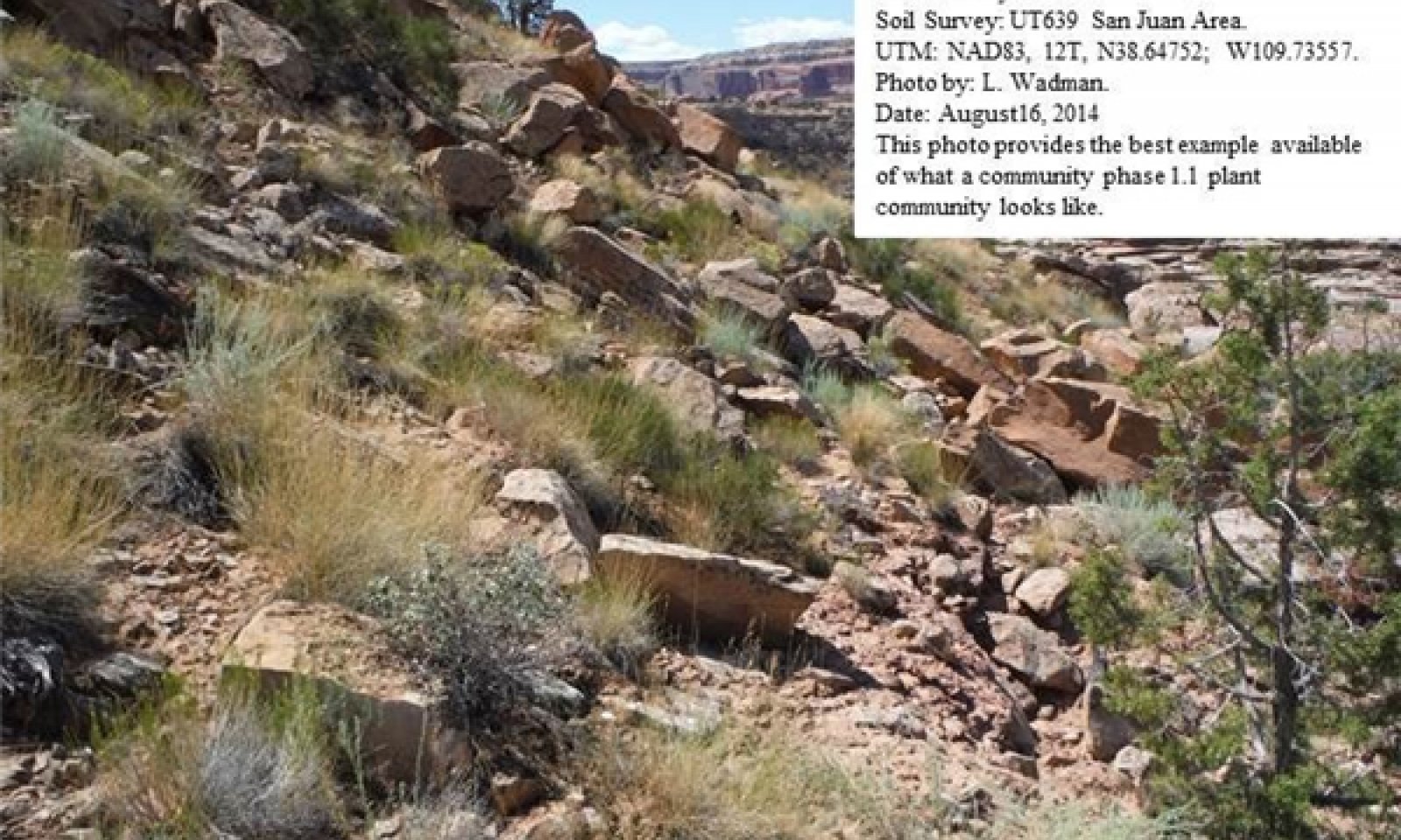
Trigger: The establishment of invasive plant species.Community 1.1
(Wet Phase) Utah Juniper/Mormon Tea/Salina Wildrye.
Figure 7. Community Phase 1.1
This wet phase of this ecological site is characterized by a sparse overstory of old Utah juniper with minor amounts of two-needle pinyon also present. A shrub layer dominates the site with Mormon tea, blackbrush, spiny hopsage and Mexican cliffrose occurring most often. A wide array of other shrubs may also present. A well developed herbaceous layer is present with Indian ricegrass, salina wildrye and James galleta occurring most often. Other commonly occurring herbaceous species include needle-and-thread and princes plume.
Air dry weight is approximately 5 percent trees, 50 percent shrubs, 5 percent forbs, and 40 percent grasses. Bare ground is variable (2-55%) depending on biological crust cover, which is also variable (0-65%).
The following tables present a typical example of the vegetative floristics of a community phase 1.1 plant community.Figure 8. Annual production by plant type (representative values) or group (midpoint values)
Table 5. Annual production by plant type
Plant type Low
(lb/acre)Representative value
(lb/acre)High
(lb/acre)Shrub/Vine 45 125 170 Grass/Grasslike 40 70 130 Forb 15 30 50 Total 100 225 350 Table 6. Ground cover
Tree foliar cover 0-0% Shrub/vine/liana foliar cover 40-40% Grass/grasslike foliar cover 20-30% Forb foliar cover 0-10% Non-vascular plants 0% Biological crusts 0% Litter 0% Surface fragments >0.25" and <=3" 0% Surface fragments >3" 0% Bedrock 0% Water 0% Bare ground 0% Table 7. Canopy structure (% cover)
Height Above Ground (ft) Tree Shrub/Vine Grass/
GrasslikeForb <0.5 – – – – >0.5 <= 1 – – – 4-6% >1 <= 2 – – 24-26% – >2 <= 4.5 – 39-41% – – >4.5 <= 13 1-3% – – – >13 <= 40 – – – – >40 <= 80 – – – – >80 <= 120 – – – – >120 – – – – Community 1.2
(Dry Phase) Blackbrush/Shadscale/Indian Ricegrass..
Figure 9. Community Phase 1.2
This dry phase of this ecological site is characterized by a shrub layer dominated by blackbrush and shadscale. Minor amounts of other shrubs including Mormon tea may also present. The herbaceous layer is very sparse with Indian ricegrass and James galleta occurring most often. Other herbaceous species may include needle-and-thread and princes plume.
Air dry weight is approximately 85 percent shrubs, 5 percent forbs, and 10 percent grasses. Bare ground is variable (2-55%) depending on biological crust cover, which is also variable (0-65%).
The following tables present a typical example of the vegetative floristics of a community phase 1.2 plant community.Figure 10. Annual production by plant type (representative values) or group (midpoint values)
Table 8. Annual production by plant type
Plant type Low
(lb/acre)Representative value
(lb/acre)High
(lb/acre)Shrub/Vine 60 130 170 Grass/Grasslike 30 75 100 Forb 10 20 30 Total 100 225 300 Table 9. Ground cover
Tree foliar cover 0-0% Shrub/vine/liana foliar cover 40-40% Grass/grasslike foliar cover 20-30% Forb foliar cover 0-10% Non-vascular plants 0% Biological crusts 0% Litter 0% Surface fragments >0.25" and <=3" 0% Surface fragments >3" 0% Bedrock 0% Water 0% Bare ground 0% Table 10. Canopy structure (% cover)
Height Above Ground (ft) Tree Shrub/Vine Grass/
GrasslikeForb <0.5 – – – – >0.5 <= 1 – – – 4-6% >1 <= 2 – – 24-26% – >2 <= 4.5 – 39-41% – – >4.5 <= 13 1-3% – – – >13 <= 40 – – – – >40 <= 80 – – – – >80 <= 120 – – – – >120 – – – – State 2
Current Potential State.This Current Potential State describes the various biotic communities that are expected to be found on this ecological site under current conditions. Two distinct phases are present and are described below as Wet and Dry Phases. Both phases now contain invasive species with Russian thistle, various mustard species and knapweed occurring most often.
The Wet Phase has a scattered overstory of Utah juniper with small amount of two-needle pinyon. A wide array of shrubs including Mormon tea, blackbrush, spiny hopsage, and Mexican cliffrose dominate the shrub layer. A well developed grass layer is often present with Indian ricegrass, salina wildrye and James galleta occurring most often. Russian thistle and annual mustard are common invasive species. This phase nearly always has a north, northeast or east aspect. It is normally at higher elevations and found in higher precipitation zones or where additional run-on moisture occurs. Its soils typically have higher Available Water Holding Capacity's (AWC) and often have fewer coarse fragments found within the soil profile.
The Dry Phase has little or no Utah juniper or two-needle pinyon present. Primary shrubs include blackbrush, shadscale, Castle Valley saltbush and Mormon tea. Herbaceous species are rare with minor amounts of Indian ricegrass and James galleta usually present. On more sandy soils, spike and mesa dropseed may be present. Russian thistle and knapweed are commonly occurring invasive species. This phase typically has a south, southwest or west aspect. It is normally at lower elevations and found in lower precipitation zones where little or on additional run-on moisture occurs. Its soils typically have lower Available Water Holding Capacity's (AWC) and often have large amounts of coarse fragments within the soil profile.
The reference state is self-sustaining and resistant to change due to good natural resilience to its natural disturbances. The primary natural disturbance mechanisms are wildlife population densities which can affect the shrub layer composition and weather fluctuations.
Definitions:
Reference State: Natural plant communities as influenced by latitude, elevation, aspect, precipitation (including run-on moisture), soil texture and depth, and the percent of coarse fragments found within the soil profile.
Indicators: These communities are highly variable with a wide array of species present specific of the physical site conditions.
Feedbacks: Natural fluctuations in weather patterns that allow for native species to be self-sustaining and prevent the establishment of invasive species.
At-risk Community Phase: All communities are at risk when native plants are stressed and conditions are created that may allow invasive plants to establish.
Trigger: The establishment of invasive plant species.Community 2.1
(Wet Phase) Utah Juniper/Blackbrush/James Galleta.
Figure 11. Community Phase 2.1
This wet phase of this ecological site is characterized by a sparse overstory of old Utah juniper with minor amounts of two-needle pinyon also present. A shrub layer dominates the site with blackbrush, Mormon tea and singleleaf ash occurring most often. A wide array of other shrubs may also present. A well developed herbaceous layer is present with James galleta and Indian ricegrass occurring most often. Other commonly occurring herbaceous species include needle-and-thread and princes plume. Invasive annuals including Russian thistle and annual mustards are often present on the site.
Air dry weight is approximately 5 percent trees, 60 percent shrubs, 5 percent forbs, and 30 percent grasses. Bare ground is variable (2-55%) depending on biological crust cover, which is also variable (0-65%).
The following tables present a typical example of the vegetative floristics of a community phase 2.1 plant community.Figure 12. Annual production by plant type (representative values) or group (midpoint values)
Table 11. Annual production by plant type
Plant type Low
(lb/acre)Representative value
(lb/acre)High
(lb/acre)Shrub/Vine 45 125 170 Grass/Grasslike 40 70 130 Forb 15 30 50 Total 100 225 350 Table 12. Ground cover
Tree foliar cover 0-0% Shrub/vine/liana foliar cover 40-40% Grass/grasslike foliar cover 20-30% Forb foliar cover 0-10% Non-vascular plants 0% Biological crusts 0% Litter 0% Surface fragments >0.25" and <=3" 0% Surface fragments >3" 0% Bedrock 0% Water 0% Bare ground 0% Table 13. Canopy structure (% cover)
Height Above Ground (ft) Tree Shrub/Vine Grass/
GrasslikeForb <0.5 – – – – >0.5 <= 1 – – – 4-6% >1 <= 2 – – 24-26% – >2 <= 4.5 – 39-41% – – >4.5 <= 13 1-3% – – – >13 <= 40 – – – – >40 <= 80 – – – – >80 <= 120 – – – – >120 – – – – Community 2.2
(Dry Phase) Castle Valley Saltbush/Spike Dropseed/Invasive Weed.
Figure 13. Community Phase 2.2
This dry phase of this ecological site is characterized by a shrub layer dominated by Castle Valley saltbush, Mormon tea and shadscale. Minor amounts of other shrubs including blackbrush may also present. The herbaceous layer is very sparse with Spike dropseed and Indian ricegrass occurring most often. Other herbaceous species may include Mesa dropseed, James galleta and princes plume. Invasive species including knapweed, halogeton and Russian thistle are present and may dominate the site.
Air dry weight is approximately 60 percent shrubs, 25 percent forbs, and 15 percent grasses. Bare ground is variable (2-55%) depending on biological crust cover, which is also variable (0-65%).
The following tables present a typical example of the vegetative floristics of a community phase 2.2 plant community.Figure 14. Annual production by plant type (representative values) or group (midpoint values)
Table 14. Annual production by plant type
Plant type Low
(lb/acre)Representative value
(lb/acre)High
(lb/acre)Shrub/Vine 60 130 170 Grass/Grasslike 30 75 100 Forb 10 20 30 Total 100 225 300 Table 15. Ground cover
Tree foliar cover 0-0% Shrub/vine/liana foliar cover 40-40% Grass/grasslike foliar cover 20-30% Forb foliar cover 0-10% Non-vascular plants 0% Biological crusts 0% Litter 0% Surface fragments >0.25" and <=3" 0% Surface fragments >3" 0% Bedrock 0% Water 0% Bare ground 0% Table 16. Canopy structure (% cover)
Height Above Ground (ft) Tree Shrub/Vine Grass/
GrasslikeForb <0.5 – – – – >0.5 <= 1 – – – 4-6% >1 <= 2 – – 24-26% – >2 <= 4.5 – 39-41% – – >4.5 <= 13 1-3% – – – >13 <= 40 – – – – >40 <= 80 – – – – >80 <= 120 – – – – >120 – – – – Transition T1A
State 1 to 2This transitional pathway occurs when any combination of heavy wildlife browsing and long periods without fire allow invasive species to occupy the site. Invasive species, however, appear to travel along road corridors and will invade adjacent sites even with healthy plant populations present.
Transition T2A
State 1 to 2This transitional pathway occurs when any combination of heavy wildlife browsing recent fire reduce blackbrush and other fire sensitive species allow invasive species to occupy the site. Invasive species, however, appear to travel along road corridors and will invade adjacent sites even with healthy plant populations present.
Additional community tables
Table 17. Community 1.1 plant community composition
Group Common name Symbol Scientific name Annual production () Foliar cover (%) Grass/Grasslike1 Dominant Grasses 100–160 saline wildrye LESAS Leymus salinus ssp. salinus 50–80 – Indian ricegrass ACHY Achnatherum hymenoides 50–80 – 2 Sub-Dominant Grasses 60–100 squirreltail ELEL5 Elymus elymoides 20–30 – needle and thread HECO26 Hesperostipa comata 20–30 – sand dropseed SPCR Sporobolus cryptandrus 10–20 – Grass, annual 2GA Grass, annual 10–20 – Grass, perennial 2GP Grass, perennial 10–20 – desert needlegrass ACSP12 Achnatherum speciosum 10–20 – purple threeawn ARPU9 Aristida purpurea 10–20 – black grama BOER4 Bouteloua eriopoda 10–20 – Forb3 Forbs 75–100 Forb, annual 2FA Forb, annual 25–35 – Forb, perennial 2FP Forb, perennial 25–35 – desert princesplume STPI Stanleya pinnata 10–20 – white sagebrush ARLU Artemisia ludoviciana 10–20 – Crescent milkvetch ASAM5 Astragalus amphioxys 5–10 – Wright's bird's beak COWR2 Cordylanthus wrightii 5–10 – Brenda's yellow cryptantha CRFL5 Cryptantha flava 5–10 – desert trumpet ERIN4 Eriogonum inflatum 5–10 – redroot buckwheat ERRA3 Eriogonum racemosum 5–10 – Utah fleabane ERUT Erigeron utahensis 5–10 – fineleaf hymenopappus HYFI Hymenopappus filifolius 5–10 – mountain pepperweed LEMO2 Lepidium montanum 5–10 – threadleaf phacelia PHLI Phacelia linearis 5–10 – gooseberryleaf globemallow SPGR2 Sphaeralcea grossulariifolia 5–10 – thrift mock goldenweed STARA Stenotus armerioides var. armerioides 5–10 – Pacific aster SYCHC Symphyotrichum chilense var. chilense 5–10 – stemless four-nerve daisy TEACA2 Tetraneuris acaulis var. acaulis 5–10 – littleleaf pussytoes ANMI3 Antennaria microphylla 5–10 – Shrub/Vine4 Dominant Shrubs 100–180 mormon tea EPVI Ephedra viridis 40–60 – singleleaf ash FRAN2 Fraxinus anomala 20–40 – spiny hopsage GRSP Grayia spinosa 20–40 – Mexican cliffrose PUME Purshia mexicana 20–40 – blackbrush CORA Coleogyne ramosissima 20–40 – 5 Sub-Dominant Shrubs 60–130 Shrub (>.5m) 2SHRUB Shrub (>.5m) 35–45 – Bigelow sage ARBI3 Artemisia bigelovii 10–20 – fourwing saltbush ATCA2 Atriplex canescens 10–20 – littleleaf brickellbush BRMI Brickellia microphylla 10–20 – yellow rabbitbrush CHVI8 Chrysothamnus viscidiflorus 10–20 – Nevada jointfir EPNE Ephedra nevadensis 10–20 – Eastern Mojave buckwheat ERFAP Eriogonum fasciculatum var. polifolium 10–20 – rubber rabbitbrush ERNA10 Ericameria nauseosa 10–20 – woolly yerba santa ERTO Eriodictyon tomentosum 10–20 – broom snakeweed GUSA2 Gutierrezia sarothrae 10–20 – Havard oak QUHA3 Quercus havardii 10–20 – skunkbush sumac RHTRT Rhus trilobata var. trilobata 10–20 – roundleaf buffaloberry SHRO Shepherdia rotundifolia 10–20 – shortspine horsebrush TESP2 Tetradymia spinosa 10–20 – Spanish bayonet YUHA Yucca harrimaniae 10–20 – Tree6 Dominant Trees 40–80 Utah juniper JUOS Juniperus osteosperma 30–60 – twoneedle pinyon PIED Pinus edulis 20–30 – Table 18. Community 1.2 plant community composition
Group Common name Symbol Scientific name Annual production () Foliar cover (%) Grass/Grasslike1 Dominant Grasses 60–100 Indian ricegrass ACHY Achnatherum hymenoides 20–30 – saline wildrye LESAS Leymus salinus ssp. salinus 10–20 – 2 Sub-Dominant Grasses 60–100 Grass, annual 2GA Grass, annual 10–20 – Grass, perennial 2GP Grass, perennial 10–20 – desert needlegrass ACSP12 Achnatherum speciosum 10–20 – purple threeawn ARPU9 Aristida purpurea 10–20 – black grama BOER4 Bouteloua eriopoda 10–20 – squirreltail ELEL5 Elymus elymoides 10–20 – needle and thread HECO26 Hesperostipa comata 10–20 – sand dropseed SPCR Sporobolus cryptandrus 10–20 – Forb3 Forbs 75–100 Forb, annual 2FA Forb, annual 25–35 – Forb, perennial 2FP Forb, perennial 25–35 – desert princesplume STPI Stanleya pinnata 10–20 – white sagebrush ARLU Artemisia ludoviciana 10–20 – Pacific aster SYCHC Symphyotrichum chilense var. chilense 5–10 – stemless four-nerve daisy TEACA2 Tetraneuris acaulis var. acaulis 5–10 – littleleaf pussytoes ANMI3 Antennaria microphylla 5–10 – Crescent milkvetch ASAM5 Astragalus amphioxys 5–10 – Wright's bird's beak COWR2 Cordylanthus wrightii 5–10 – Brenda's yellow cryptantha CRFL5 Cryptantha flava 5–10 – desert trumpet ERIN4 Eriogonum inflatum 5–10 – redroot buckwheat ERRA3 Eriogonum racemosum 5–10 – Utah fleabane ERUT Erigeron utahensis 5–10 – fineleaf hymenopappus HYFI Hymenopappus filifolius 5–10 – mountain pepperweed LEMO2 Lepidium montanum 5–10 – threadleaf phacelia PHLI Phacelia linearis 5–10 – gooseberryleaf globemallow SPGR2 Sphaeralcea grossulariifolia 5–10 – thrift mock goldenweed STARA Stenotus armerioides var. armerioides 5–10 – Shrub/Vine4 Dominant Shrubs 100–180 blackbrush CORA Coleogyne ramosissima 20–40 – mormon tea EPVI Ephedra viridis 20–40 – singleleaf ash FRAN2 Fraxinus anomala 20–40 – spiny hopsage GRSP Grayia spinosa 20–40 – Mexican cliffrose PUME Purshia mexicana 20–40 – 5 Sub-Dominant Shrubs 60–130 Shrub (>.5m) 2SHRUB Shrub (>.5m) 35–45 – Bigelow sage ARBI3 Artemisia bigelovii 10–20 – fourwing saltbush ATCA2 Atriplex canescens 10–20 – littleleaf brickellbush BRMI Brickellia microphylla 10–20 – yellow rabbitbrush CHVI8 Chrysothamnus viscidiflorus 10–20 – Nevada jointfir EPNE Ephedra nevadensis 10–20 – Eastern Mojave buckwheat ERFAP Eriogonum fasciculatum var. polifolium 10–20 – rubber rabbitbrush ERNA10 Ericameria nauseosa 10–20 – woolly yerba santa ERTO Eriodictyon tomentosum 10–20 – broom snakeweed GUSA2 Gutierrezia sarothrae 10–20 – Havard oak QUHA3 Quercus havardii 10–20 – skunkbush sumac RHTRT Rhus trilobata var. trilobata 10–20 – roundleaf buffaloberry SHRO Shepherdia rotundifolia 10–20 – shortspine horsebrush TESP2 Tetradymia spinosa 10–20 – Spanish bayonet YUHA Yucca harrimaniae 10–20 – Tree6 Dominant Trees 40–80 Utah juniper JUOS Juniperus osteosperma 5–10 – twoneedle pinyon PIED Pinus edulis 1–5 – Table 19. Community 2.1 plant community composition
Group Common name Symbol Scientific name Annual production () Foliar cover (%) Grass/Grasslike1 Dominant Grasses 100–160 saline wildrye LESAS Leymus salinus ssp. salinus 30–50 – Indian ricegrass ACHY Achnatherum hymenoides 30–50 – 2 Sub-Dominant Grasses 60–100 cheatgrass BRTE Bromus tectorum 20–30 – squirreltail ELEL5 Elymus elymoides 20–30 – needle and thread HECO26 Hesperostipa comata 20–30 – sand dropseed SPCR Sporobolus cryptandrus 10–20 – Grass, annual 2GA Grass, annual 10–20 – Grass, perennial 2GP Grass, perennial 10–20 – desert needlegrass ACSP12 Achnatherum speciosum 10–20 – purple threeawn ARPU9 Aristida purpurea 10–20 – black grama BOER4 Bouteloua eriopoda 10–20 – red brome BRRU2 Bromus rubens 10–20 – Forb3 Forbs 75–100 Forb, annual 2FA Forb, annual 25–35 – Forb, perennial 2FP Forb, perennial 25–35 – desert princesplume STPI Stanleya pinnata 10–20 – white sagebrush ARLU Artemisia ludoviciana 10–20 – Crescent milkvetch ASAM5 Astragalus amphioxys 5–10 – crossflower CHTE2 Chorispora tenella 5–10 – Wright's bird's beak COWR2 Cordylanthus wrightii 5–10 – Brenda's yellow cryptantha CRFL5 Cryptantha flava 5–10 – western tansymustard DEPI Descurainia pinnata 5–10 – herb sophia DESO2 Descurainia sophia 5–10 – desert trumpet ERIN4 Eriogonum inflatum 5–10 – redroot buckwheat ERRA3 Eriogonum racemosum 5–10 – Utah fleabane ERUT Erigeron utahensis 5–10 – fineleaf hymenopappus HYFI Hymenopappus filifolius 5–10 – mountain pepperweed LEMO2 Lepidium montanum 5–10 – threadleaf phacelia PHLI Phacelia linearis 5–10 – Russian thistle SAKA Salsola kali 5–10 – gooseberryleaf globemallow SPGR2 Sphaeralcea grossulariifolia 5–10 – thrift mock goldenweed STARA Stenotus armerioides var. armerioides 5–10 – Pacific aster SYCHC Symphyotrichum chilense var. chilense 5–10 – stemless four-nerve daisy TEACA2 Tetraneuris acaulis var. acaulis 5–10 – littleleaf pussytoes ANMI3 Antennaria microphylla 5–10 – Shrub/Vine4 Dominant Shrubs 100–180 blackbrush CORA Coleogyne ramosissima 40–60 – mormon tea EPVI Ephedra viridis 40–60 – singleleaf ash FRAN2 Fraxinus anomala 20–40 – spiny hopsage GRSP Grayia spinosa 20–40 – Mexican cliffrose PUME Purshia mexicana 20–40 – 5 Sub-Dominant Shrubs 60–130 Shrub (>.5m) 2SHRUB Shrub (>.5m) 35–45 – Bigelow sage ARBI3 Artemisia bigelovii 10–20 – fourwing saltbush ATCA2 Atriplex canescens 10–20 – littleleaf brickellbush BRMI Brickellia microphylla 10–20 – yellow rabbitbrush CHVI8 Chrysothamnus viscidiflorus 10–20 – Nevada jointfir EPNE Ephedra nevadensis 10–20 – Eastern Mojave buckwheat ERFAP Eriogonum fasciculatum var. polifolium 10–20 – rubber rabbitbrush ERNA10 Ericameria nauseosa 10–20 – woolly yerba santa ERTO Eriodictyon tomentosum 10–20 – broom snakeweed GUSA2 Gutierrezia sarothrae 10–20 – Havard oak QUHA3 Quercus havardii 10–20 – skunkbush sumac RHTRT Rhus trilobata var. trilobata 10–20 – roundleaf buffaloberry SHRO Shepherdia rotundifolia 10–20 – shortspine horsebrush TESP2 Tetradymia spinosa 10–20 – Spanish bayonet YUHA Yucca harrimaniae 10–20 – Tree6 Dominant Trees 40–80 Utah juniper JUOS Juniperus osteosperma 30–60 – twoneedle pinyon PIED Pinus edulis 20–30 – Table 20. Community 2.2 plant community composition
Group Common name Symbol Scientific name Annual production () Foliar cover (%) Grass/Grasslike1 Dominant Grasses 60–100 spike dropseed SPCO4 Sporobolus contractus 20–40 – Indian ricegrass ACHY Achnatherum hymenoides 20–30 – saline wildrye LESAS Leymus salinus ssp. salinus 10–20 – 2 Sub-Dominant Grasses 60–100 Grass, annual 2GA Grass, annual 10–20 – Grass, perennial 2GP Grass, perennial 10–20 – desert needlegrass ACSP12 Achnatherum speciosum 10–20 – purple threeawn ARPU9 Aristida purpurea 10–20 – black grama BOER4 Bouteloua eriopoda 10–20 – red brome BRRU2 Bromus rubens 10–20 – cheatgrass BRTE Bromus tectorum 10–20 – squirreltail ELEL5 Elymus elymoides 10–20 – needle and thread HECO26 Hesperostipa comata 10–20 – sand dropseed SPCR Sporobolus cryptandrus 10–20 – mesa dropseed SPFL2 Sporobolus flexuosus 10–20 – Forb3 Forbs 75–100 diffuse knapweed CEDI3 Centaurea diffusa 30–60 – Russian thistle SAKA Salsola kali 30–60 – herb sophia DESO2 Descurainia sophia 30–60 – Forb, annual 2FA Forb, annual 25–35 – Forb, perennial 2FP Forb, perennial 25–35 – white sagebrush ARLU Artemisia ludoviciana 10–20 – desert princesplume STPI Stanleya pinnata 10–20 – Pacific aster SYCHC Symphyotrichum chilense var. chilense 5–10 – stemless four-nerve daisy TEACA2 Tetraneuris acaulis var. acaulis 5–10 – gooseberryleaf globemallow SPGR2 Sphaeralcea grossulariifolia 5–10 – thrift mock goldenweed STARA Stenotus armerioides var. armerioides 5–10 – Wright's bird's beak COWR2 Cordylanthus wrightii 5–10 – Brenda's yellow cryptantha CRFL5 Cryptantha flava 5–10 – Crescent milkvetch ASAM5 Astragalus amphioxys 5–10 – littleleaf pussytoes ANMI3 Antennaria microphylla 5–10 – desert trumpet ERIN4 Eriogonum inflatum 5–10 – redroot buckwheat ERRA3 Eriogonum racemosum 5–10 – Utah fleabane ERUT Erigeron utahensis 5–10 – fineleaf hymenopappus HYFI Hymenopappus filifolius 5–10 – mountain pepperweed LEMO2 Lepidium montanum 5–10 – threadleaf phacelia PHLI Phacelia linearis 5–10 – Shrub/Vine4 Dominant Shrubs 100–180 valley saltbush ATCU Atriplex cuneata 20–40 – blackbrush CORA Coleogyne ramosissima 20–40 – mormon tea EPVI Ephedra viridis 20–40 – singleleaf ash FRAN2 Fraxinus anomala 20–40 – spiny hopsage GRSP Grayia spinosa 20–40 – Mexican cliffrose PUME Purshia mexicana 20–40 – 5 Sub-Dominant Shrubs 60–130 Shrub (>.5m) 2SHRUB Shrub (>.5m) 35–45 – Bigelow sage ARBI3 Artemisia bigelovii 10–20 – fourwing saltbush ATCA2 Atriplex canescens 10–20 – littleleaf brickellbush BRMI Brickellia microphylla 10–20 – yellow rabbitbrush CHVI8 Chrysothamnus viscidiflorus 10–20 – Nevada jointfir EPNE Ephedra nevadensis 10–20 – Eastern Mojave buckwheat ERFAP Eriogonum fasciculatum var. polifolium 10–20 – rubber rabbitbrush ERNA10 Ericameria nauseosa 10–20 – woolly yerba santa ERTO Eriodictyon tomentosum 10–20 – broom snakeweed GUSA2 Gutierrezia sarothrae 10–20 – Havard oak QUHA3 Quercus havardii 10–20 – skunkbush sumac RHTRT Rhus trilobata var. trilobata 10–20 – roundleaf buffaloberry SHRO Shepherdia rotundifolia 10–20 – shortspine horsebrush TESP2 Tetradymia spinosa 10–20 – Spanish bayonet YUHA Yucca harrimaniae 10–20 – Tree6 Dominant Trees 40–80 Utah juniper JUOS Juniperus osteosperma 5–10 – twoneedle pinyon PIED Pinus edulis 1–5 – Interpretations
Animal community
--Livestock and Wildlife Grazing--
Due to the steep slopes associated with this site, livestock grazing is generally not a factor. This site provides fair grazing conditions for wildlife. However, this site often lacks natural perennial water sources, which can influence the suitability for wildlife grazing. Mule deer, desert bighorn sheep, pronghorn antelope, and elk may utilize this site, though in many places the populations will be small and have little grazing impact.
The plant community is primarily shrubs, with the majority of canopy cover being attributed to shadscale and blackbrush; sub-dominants include Mormon tea and castle valley saltbush. These shrubs provide fair year round browse for bighorn sheep, mule deer, elk and pronghorn antelope. When present, grasses, primarily Indian ricegrass, Salina wildrye, and galleta, provide good year round grazing conditions for all classes of wildlife. Forb composition and annual production depends primarily on precipitation amounts and thus is challenging to use in wildlife use interpretations.Hydrological functions
The soils associated with this ecological site are generally in Hydrologic Soil Groups B and C due to steep slopes (NRCS National Engineering Handbook). Once these soils become saturated, run off potential is high. Hydrological groups are used in equations that estimate runoff from rainfall. These estimates are needed for solving hydrologic problems that arise in planning watershed-protection and flood-prevention projects and for designing structures for the use, control and disposal of water.
Recreational uses
Recreation is limited because of steep slopes. Natural beauty lies in the topography, soils, and plants.
Wood products
Firewood.
Other information
--Invasive Plant Communities--
Generally as ecological conditions deteriorate and perennial vegetation decreases due to disturbance (fire, over grazing, drought, off road vehicle overuse, erosion, etc.) annual forbs and grasses will invade the site. Of particular concern in semi-arid environments are annual invaders including cheatgrass, Russian thistle, kochia, halogeton, and annual mustards. The presence of these species will depend on soil properties and moisture availability; however, these invaders are highly adaptive and can flourish in many locations. Once established, complete removal is difficult but suppression may be possible. At this time, in most of the Colorado Plateau area, cheatgrass is not known to invade blackbrush associations as it does in areas of southwest Utah and the Mojave.
Due to the steep slopes associate with this site, the chance for disturbance is rare and thus possibility for invasion decreases. However, cheatgrass and Russian thistle are expected to invade when given the opportunity.
--Fire Ecology--
The ability for an ecological site to carry fire depends primarily on the present fuel load and plant moisture content—sites with small fuel loads will burn more slowly and less intensely than sites with large fuel loads. Many semi-desert communities in the Colorado Plateau may have evolved without the influence of fire. However a year of exceptionally heavy winter rains can generate fuels by producing heavy stands of annual forbs and grasses. When fires do occur, the effect on the plant community may be extreme due to the harsh environment and slow rate of recovery.
Due to the steep slopes, large expanses of bare ground, and little plant cover, fire is unlikely to carry through this site unless under high winds, high temperature, and low humidity. However if annual grasses or forbs dominate the area after disturbance, an increase in fire frequency could result.Supporting information
Other references
Relative Forage Preference of Plants for Grazing Use by Season: Plants commonly found in Major Land Resource Area D35 --The Colorado Plateau. 2007
Stubbendieck, J., S. L. Hatch, and C. H. Butterfield. 1997. North American range plants. Lincoln, NE: University of Nebraska Press. 501p.
USDA, Forest Service. 2007. Fire effects information: plant species life form. Available at http://www.fs.fed.us/database/feis/plants/index.html. Accessed 7 August 2007.
West, N. E. 1983. Colorado plateau-Mohavian blackbrush semi-desert. In: West, Neil E., ed. Temperate deserts and semi-deserts. New York: Elsevier Scientific Publishing Company: 399-411. (Goodall, David W., ed. in chief; Ecosystems of the world; vol. 5). [2508]
Knight, A. P. and R. G. Walter. 2001. A guide to plant poisoning of animals in North America. Jackson, WY: Teton NewMedia. 367p.
Contributors
George Cook
V. Keith WadmanRangeland health reference sheet
Interpreting Indicators of Rangeland Health is a qualitative assessment protocol used to determine ecosystem condition based on benchmark characteristics described in the Reference Sheet. A suite of 17 (or more) indicators are typically considered in an assessment. The ecological site(s) representative of an assessment location must be known prior to applying the protocol and must be verified based on soils and climate. Current plant community cannot be used to identify the ecological site.
Author(s)/participant(s) Robert Stager (BLM), Randy Beckstrand (BLM), Dana Truman (NRCS), Paul Curtis (BLM), Shane A. Green (NRCS). Updated by V. Keith Wadman (NRCS, Retired) to include new concepts and terminology. Contact for lead author shane.green@ut.usda.gov Date 08/20/2014 Approved by Approval date Composition (Indicators 10 and 12) based on Annual Production Indicators
-
Number and extent of rills:
None to very rare. Due to the talus characteristic of this site, traditional rill formation may not be evident. The overall gravelly to bouldery surface is expected to be resistant to rill formation and accelerated erosion. -
Presence of water flow patterns:
Flow patterns are sinuous and wind around gravel and/or boulders, and perennial plant bases. They show some evidence of fines and litter depositing against obstructions of gravel, rocks, boulders, and plants. During large precipitation, these sites are expected to shed large volumes of water to adjacent ecological sites. -
Number and height of erosional pedestals or terracettes:
Pedestals or terracettes are rare due to the talus nature of the site. They may naturally occur where the water flows around the gravel, rock or boulders. -
Bare ground from Ecological Site Description or other studies (rock, litter, lichen, moss, plant canopy are not bare ground):
5–10%. With a surface texture ranging from gravelly loam to extremely bouldery loam and a talus surface, actual bare ground (soil) should be a minor component. Poorly developed biological soil crusts that are interpreted as functioning as bare ground (therefore they would be susceptible to raindrop splash erosion) should be recorded as bare ground. -
Number of gullies and erosion associated with gullies:
None to few. If present, gullies may be wide and shallow and armored with very large rocks. -
Extent of wind scoured, blowouts and/or depositional areas:
None. The talus nature of this site precludes this from occurring. -
Amount of litter movement (describe size and distance expected to travel):
Due to the steepness of slope being between 50 to 70 percent, down slope redistribution of any incident litter caused by water is expected. Deposition would likely occur at points of obstruction such as the uphill side of gravel, rocks and boulders, especially following major storm events. -
Soil surface (top few mm) resistance to erosion (stability values are averages - most sites will show a range of values):
This site should have an average soil stability rating 4 using the soil stability test kit. Surface texture is gravelly loam to extremely bouldery loam. Vegetation cover, litter, biological soil crusts and surface rock reduce erosion. -
Soil surface structure and SOM content (include type of structure and A-horizon color and thickness):
(Myton) Soil surface horizon is typically 0 to 4 inches deep. Structure is typically weak and moderate very fine granular to massive. Color is typically brown (7.5YR 5/2) to light red (2.5YR 4/6). Use the specific information for the soil you are assessing found in the published soil survey to supplement this description. -
Effect of community phase composition (relative proportion of different functional groups) and spatial distribution on infiltration and runoff:
Due to the talus and steep nature of this site, plants would be expected to only have a minor effect on infiltration and runoff. The armored gravelly to bouldery surface would naturally shed a majority of the incident water. -
Presence and thickness of compaction layer (usually none; describe soil profile features which may be mistaken for compaction on this site):
None. -
Functional/Structural Groups (list in order of descending dominance by above-ground annual-production or live foliar cover using symbols: >>, >, = to indicate much greater than, greater than, and equal to):
Dominant:
Non-sprouting shrubs (Shadscale, Blackbrush) > Perennial bunchgrasses (Indian ricegrass, Salina wildrye, James galleta)Sub-dominant:
Sprouting shrubs (Torrey jointfir, Low rabbitbrush, skunkbrush sumac) > = perennial and native annual forbsOther:
Functional/structural groups may appropriately contain non-native species if their ecological function is the same as the native species in the reference state (e.g. Crested wheatgrass, Intermediate wheatgrass, etc.) Biological soil crust is variable in its expression where present on this site and is measured as a component of ground cover. Forbs can be expected to vary widely in their expression in the plant community based upon departures from average growing conditions.Additional:
Assumed disturbance regime includes insects and very infrequent fire that kills the non-sprouting shrub species. Temporal variability is caused by very rare fires, droughts, insects or other pathogens, etc. and spatial variability is caused by slope, aspect and topography. Following a recent disturbance such as fire, drought, or insects that removes the woody vegetation, forbs and perennial grasses (herbaceous species) may dominate the community. If a disturbance has not occurred for an extended period of time, woody species may continue to increase crowding out the perennial herbaceous understory species. In either case, these conditions would reflect a community phase within the reference state. -
Amount of plant mortality and decadence (include which functional groups are expected to show mortality or decadence):
During years with average to above average precipitation, there should be very little recent mortality or decadence apparent in either the shrubs or grasses. During severe (multi year) droughts, up to 20% of the blackbrush stems may die. Some mortality of bunchgrass and other shrubs may occur during very severe (long term) droughts. There may be partial mortality of individual bunchgrasses and other shrubs during less severe droughts. Because woody stems may persist for many years, blackbrush will normally have dead stems within the plant canopy. Blackbrush will drop it’s leaves when water stressed. -
Average percent litter cover (%) and depth ( in):
Litter cover (including under plants) Depth should be 1 leaf thickness in the interspaces and up to 1/8” under canopies. Litter cover may increase up to 20% immediately following leaf drop. Litter redistribution following natural extreme runoff events can reduce litter cover by concentrating it in low lying areas. Litter cover may increase to 3-6% following seasons with above average production with a high production of biomass. -
Expected annual annual-production (this is TOTAL above-ground annual-production, not just forage annual-production):
Total annual production should average 200 to 225 lbs./acre on an average year. Total production could vary from 50 to 400 lbs./acre during drought years or above average precipitation years. -
Potential invasive (including noxious) species (native and non-native). List species which BOTH characterize degraded states and have the potential to become a dominant or co-dominant species on the ecological site if their future establishment and growth is not actively controlled by management interventions. Species that become dominant for only one to several years (e.g., short-term response to drought or wildfire) are not invasive plants. Note that unlike other indicators, we are describing what is NOT expected in the reference state for the ecological site:
Cheatgrass, knapweed, annual mustards and Russian thistle may invade site. -
Perennial plant reproductive capability:
All perennial plants should have the ability to reproduce sexually or asexually in most years, except in extreme drought years. Blackbrush reproduction is naturally very episodic and no young plants may be apparent.
Print Options
Sections
Font
AAAAOther
PrintThe Ecosystem Dynamics Interpretive Tool is an information system framework developed by the USDA-ARS Jornada Experimental Range, USDA Natural Resources Conservation Service, and New Mexico State University.
Accessibility statement