Natural Resources
Conservation Service
-
Search


Major Land Resource Area or ecological site by name and/or ID.
PreviousSectionsNextGeneral information
Provisional. A provisional ecological site description has undergone quality control and quality assurance review. It contains a working state and transition model and enough information to identify the ecological site.
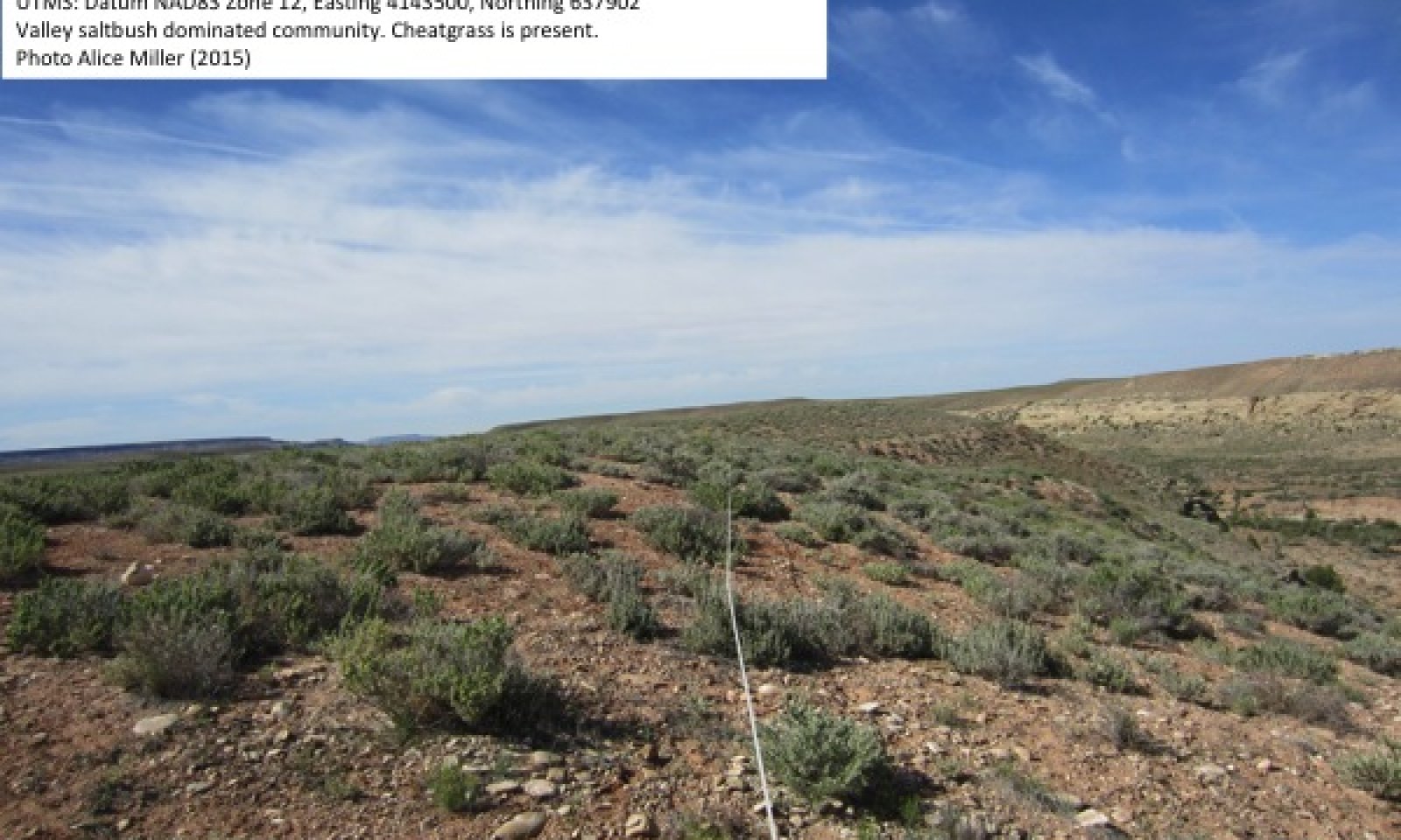
Click to explore map
Figure 1. Mapped extent
Areas shown in blue indicate the maximum mapped extent of this ecological site. Other ecological sites likely occur within the highlighted areas. It is also possible for this ecological site to occur outside of highlighted areas if detailed soil survey has not been completed or recently updated.
Classification relationships
Atriplex cuneata shrubland alliance (Western Ecology Working Group of NatureServe. No date).
Ecological site concept
This site occurs in the semidesert zone of the Colorado and Green River Plateaus Region (MLRA 35) in southeastern Utah. It is found on a variety of typically gently sloping landforms that occur near outcroppings of shale bedrock at elevations from 4400 to 6600 feet. Soils are fine-textured, typically very deep (although may be moderately deep), and formed in alluvium and or residuum derived mainly from shale. Soils are well drained with vey slow to slow permeability. Soils are alkaline, with pH commonly between 8.0 and 9.0, and saline. Average annual precipitation ranges from 8 to 13 inches, but this site receives some run-in moisture from associated shale outcrops during high intensity convection storms. The soil moisture regime is typic to ustic aridic and the soil temperature regime is mesic. The plant community is characterized by a dwarf shrubland dominated by valley saltbush (Atriplex cuneata). James’ galleta (Pleuraphis jamesii) and Indian ricegrass (Achnatherum hymenoides) are common associates. Relatively low vegetative cover with high amounts of bare ground are typical on the fine alkaline and saline soils of this site.
Associated sites
R035XY009UT Alkali Flat (Greasewood)
This site occurs on adjacent fan remnants and alluvial fans and is dominated by shadscale (Atriplex confertifolia).
R035XY011UT Loamy Bottom (Basin Big Sagebrush)
This site occurs on adjacent fan terraces on valley sides and is dominated by basin big sagebrush (Artemisia tridentata subsp. tridentata).
R035XY103UT Desert Clay (Castle Valley Saltbush)
This site occurs on adjacent benches and mesas with shallow soils. It is also dominated by valley saltbush, but production is lower.
R035XY115UT Desert Sand (Sand Sagebrush)
This site occurs on adjacent alluvial fans and is dominated by bud sagebrush (Artemisia filifolia).
R035XY136UT Desert Stony Loam (Shadscale-Bud Sagebrush)
This site occurs on adjacent terraces and is dominated by shadscale (Atriplex confertifolia).
R035XY209UT Semidesert Loam (Wyoming Big Sagebrush)
This site occurs on adjacent small fans on valley sides and is dominated by Wyoming big sagebrush (Artemisia tridentata subsp. wyomingensis).
R035XY221UT Semidesert Shallow Loam (Utah Juniper-Pinyon)
This site occurs on adjacent structural benches and ridges above R03XY006UT, and is dominated by Utah juniper (Juniperus osteosperma) and twoneedle pinyon (Pinus edulis).
R035XY230UT Semidesert Shallow Sandy Loam (Shadscale)
This site occurs on adjacent structural benches and is dominated by shadscale (Atriplex confertifolia).
R035XY239UT Semidesert Shallow Clay (Shadscale-Utah Juniper)
This site occurs on adjacent steep hillsides and is dominated by Utah juniper (Juniperus osteosperma) and twoneedle pinyon (Pinus edulis).
Similar sites
R035XY103UT Desert Clay (Castle Valley Saltbush)
This ecological site has similar species composition, and occurs on fine alkaline soils; however soils are shallow to moderately deep, and production potential is lower.
Table 1. Dominant plant species
Tree Not specified
Shrub (1) Atriplex cuneata
Herbaceous (1) Pleuraphis jamesii
(2) Achnatherum hymenoidesPhysiographic features
This site occurs on fan terraces, alluvial fans, structural benches, mesas, valley sides and valley floors, and is usually found near outcroppings of shale bedrock. Elevations may range from 4400 to 6600 feet. Slopes may range from 1-20%, but 2-8% is typical. Runoff ranges from medium to very high, but high is typical.
Table 2. Representative physiographic features
Landforms (1) Structural bench
(2) Alluvial fan
(3) Valley side
Flooding frequency None Ponding frequency None Elevation 4400 – 6600 ft Slope 2 – 8 % Aspect Aspect is not a significant factor Climatic features
The climate is characterized by hot summers and cool winters. Large fluctuations in daily temperature are common. The majority of precipitation comes with summer monsoons from July through October, while winter rains are typical from December through March. April, May, and June are the driest months. Precipitation is variable from month to
month and from year to year, but typically ranges between 8 and 13 inches. This site receives some run-in moisture from associated shale outcrops during high intensity convection storms.Table 3 Representative climatic features
Frost-free period (average) 130 days Freeze-free period (average) 160 days Precipitation total (average) 10 in BarLineFigure 2. Monthly precipitation range
BarLineFigure 3. Monthly average minimum and maximum temperature
Figure 4. Annual precipitation pattern
Figure 5 Annual average temperature pattern
Climate stations used
-
(1) BLANDING [USC00420738], Blanding, UT
-
(2) HANKSVILLE [USW00023170], Hanksville, UT
-
(3) ESCALANTE [USC00422592], Escalante, UT
">Influencing water features
This site is not typically influenced by streams or wetlands.
Soil features
The soils associated with this ecological site are fine-textured, moderately to very deep, and formed in alluvium and or residuum derived mainly from shale, and less commonly from sandstone, diorite, and sedimentary rock. Soils are well drained with very slow to slow permeability. The soil moisture regime is typic to ustic aridic and the soil temperature regime is mesic. Soils are sodium affected and alkaline, with pH commonly between 8.0 and 9.0. Surface rock fragments smaller than 3 inches in diameter range from 0 to 26 % cover, and larger fragments range from 0 to 3%. Surface textures are clay, fine sandy loam, gravelly clay loam, gravelly loam and sandy clay loam. Subsurface rock fragments smaller than 3 inches in diameter range from 0 to 60% by volume, and larger fragments range from 0 to 3%. The soils correlated to this site include Leebench (Fine-loamy, mixed, superactive, mesic Typic Natrargids), Baldfield (Fine, smectitic, calcareous, mesic Ustertic Torriorthents) and Baldfield saline, Littlenan (Fine, smectitic, mesic Ustertic Haplocambids), and Tohona (Fine, smectitic, mesic Vertic Natrigypsids). Leebench and Baldfield soils are very deep while Littlenan and Tohona soils are moderately deep.
This ecological site has been correlated to the following mapunits and soil components:
UT636 - Panguitch Area - 10 - Baldfield (85%)
UT636 - Panguitch Area - 11 - Baldfield (85%)
UT686 - Grand Staircase-Escalante National Monument - 5090 - Baldfield saline (75%)
UT631 - Henry Mountains Area - 16 - Leebench (30%)
UT631 - Henry Mountains Area - 43 - Leebench (90%)
UT631 - Henry Mountains Area - 44 - Leebench (60%)
UT631 - Henry Mountains Area - 101 - Leebench (30%)
UT638 - San Juan County, Central Part -18 - Littlenan (30%)
UT638 - San Juan County, Central Part-19 - Littlenan (35%)
UT638 -San Juan County, Central Part - 47 - Littlenan (20%)
UT643 - Navajo Indian Reservation, San Juan County - TnC - Tohona (80%)
Typical Soil Profile (Baldfield):
A--0-2 inches; clay; strongly calcareous; strongly alkaline
C1--2-4 inches; clay; slightly calcareous; strongly alkaline
C2--4-15 inches; clay; slightly calcareous; strongly alkaline
C3--15-60 inches; clay; slightly calcareous; strongly alkaline
Table 4. Representative soil features
Parent material (1) Alluvium – shale
Surface texture (1) Clay
(2) Gravelly loam
(3) Sandy clay loam
Family particle size (1) Clayey
Drainage class Well drained Permeability class Very slow to slow Soil depth 20 – 0 in Surface fragment cover <=3" 0 – 26 % Surface fragment cover >3" 0 – 3 % Available water capacity
(0-40in)2.6 – 7.1 in Calcium carbonate equivalent
(0-40in)2 – 30 % Electrical conductivity
(0-40in)0 – 16 mmhos/cm Sodium adsorption ratio
(0-40in)0 – 20 Soil reaction (1:1 water)
(0-40in)7.9 – 9 Subsurface fragment volume <=3"
(Depth not specified)0 – 60 % Subsurface fragment volume >3"
(Depth not specified)0 – 3 % Ecological dynamics
This site occurs in the semidesert zone of the Colorado and Green River Plateaus Region (MLRA 35) in southeastern Utah. It is found on a variety of typically gently sloping landforms that occur near outcroppings of shale bedrock at elevations from 4400 to 6600 feet. Soils are fine-textured, typically very deep (although may be moderately deep), and formed in alluvium and or residuum derived mainly from shale. Soils are well drained with vey slow to slow permeability. Soils are alkaline, with pH commonly between 8.0 and 9.0, and saline. Average annual precipitation ranges from 8 to 13 inches, and this site may receive some run-in moisture from associated shale outcrops during high intensity convection storms. Additional run-in moisture may increase productivity of the plant community, but excessive moisture will run-off and may result in erosion due to the low permeability of the soils typical of this site. The soil moisture regime is typic to ustic aridic and the soil temperature regime is mesic. The plant community is characterized by a dwarf salt desert shrubland dominated by valley saltbush. James’ galleta and Indian ricegrass are common associates.
Valley saltbush is a dwarf shrub that occurs on heavy, highly alkaline soils on the Colorado Plateau (Blaisdell and Holmgren 1984, Tuhey and MacMahon 1988, Romme 1993). Relatively low vegetative cover with high amounts of bare ground are typical on the fine alkaline and saline soils of this site. This site developed with a natural disturbance regime that included decadal level variation in precipitation with alternating wet and dry periods, including severe drought (Swetnam and Betancourt 1998, Hereford et al. 2002, Miller 2004, Schwinning et al. 2008), and light grazing by native ungulates (Mack and Thompson 1982, Cole et al. 1997, Neff et al. 2005, Schwinning et al. 2008). Fire was minimal due to low vegetative cover and fine fuels. Current disturbances impacting this site include climatic variation, livestock grazing, invasion by non-native species and climate change.
Decadal scale variation in precipitation due to the Pacific Decadal Oscillation (PDO) has characterized the climate of the Colorado Plateau over the last century, with a wet period from 1905-1941, a dry period between 1942-1977, a wet period from 1978-1998, and a dry period from 1999 to the present, with a particularly catastrophic drought in 2002 (Ehleringer et al. 2000, Hereford et al. 2002, Miller 2004, Schwinning et al. 2008). These fluctuations can change plant community composition, cover and production (Blaisdell and Holmgren 1984, Swetnam and Betancourt 1998, Illius and O'Connor 1999, Ehleringer et al. 2000, Briske et al. 2003, Neff et al. 2005). In this ecological site precipitation fluctuations can have huge impacts on ecological dynamics, with valley saltbush cover fluctuating by up to 86 percent (Goodrich and Zobell 2010). Drought also impacts perennial grasses, with cool-season species like Indian ricegrass more likely to suffer losses than warm season grasses like James’ galleta. In the reference community, fluctuations in cover and species dominance would have naturally occurred, but the introduction of non-native species in the altered states of this site have permanently altered community dynamics. The loss of cover makes this site extremely susceptible to invasion by the non-native annual forb halogeton (Halogeton glomeratus) (e.g. Goodrich and Zobell 2010).
Historically the Colorado Plateau experienced only light grazing by native ungulates whose populations were kept in check by native predators such as mountain lions and wolves (Mack and Thompson 1982, Cole et al. 1997, Schwinning et al. 2008). Intensive and pervasive livestock grazing by sheep and cattle was introduced to the region in the 1880s, and it is very difficult to find areas, especially in the salt desert zone, not impacted by grazing at some level (Blaisdell and Holmgren 1984, Neff et al. 2005). Today close to 90% of the Colorado Plateau is still used for grazing, although at significantly lower densities, and with significantly less sheep than in earlier times (Young 2002, Schwinning et al. 2008). Intensive grazing caused severe depletion of salt desert vegetation, with up to 70% reduction in grazing capacity compared to the historic, pre-grazing state (e.g. Stewart et al. 1940, Blaisdell and Holmgren 1984). Depletion of vegetative cover exposed the fragile fine soils of this site to erosion by wind and water (Blaisdell and Holmgren 1984), and increased site susceptibility to invasion by non-native plants (Stoddart et al. 1951, Cronin and Williams 1966, Blaisdell and Holmgren 1984, Baker and Kennedy 1985, Young 2002, Duda et al. 2003, Goodrich and Zobell 2010). The most prevalent and damaging invaders have been halogeton and cheatgrass (Bromus tectorum) (Blaisdell and Holmgren 1984).
Halogeton is an introduced annual forb from central Asia that has infested millions of acres of salt desert across the western United States since it was accidentally introduced in the 1930s (Young 2002, Goodrich and Zobell 2010). It has typically been considered an indicator of degraded range condition, with intact vegetation unlikely to be invaded or dominated due to competition from established species (e.g. Stoddart et al. 1951, Cronin and Williams 1966, Blaisdell and Holmgren 1984, Young 2002). However, natural disturbances such as drought, which remove vegetative cover may also increase susceptibility to halogeton invasion, and halogeton may increase at the expense of established vegetation even if the vegetation has been protected from grazing (Goodrich and Zobell 2010). Halogeton has eliminated Gardner’s saltbush, which is closely related to valley saltbush, within 15 years in Wyoming (Goodrich and Zobell 2010). Halogeton is highly tolerant of drought and saline soils, and has two types of seeds, which render it very difficult to treat. Most seeds germinate readily with adequate precipitation, and are viable for one year, but about a third of the seed remains dormant at initial dispersal, and remains viable for at least 10 years (Cronin and Williams 1966). Thus any short-term treatment that disturbs soils and removes existing vegetation makes sites even more susceptible to continued halogeton invasion from the seed bank (Stoddart et al. 1951). Once established, halogeton alters soil chemistry by drawing up sodium from deep in the soil profile and leaching it back into the soil surface from plant litter (Duda et al. 2003). It also alters soil ecology, with halogeton dominated sites having higher soil bacteria than non-invaded sites (Duda et al. 2003). These are significant changes that have ecosystem level consequences. Cheatgrass is also a problem in this ecological site, and although it is more likely to gain dominance in disturbed sites, it may become abundant in fairly intact vegetation. Cheatgrass can introduce a fire dynamic into systems that typically do not burn by creating continuous fine fuels in shrub interspaces (e.g. D'Antonio and Vitousek 1992). Cheatgrass was observed in this ecological site, but not to the extent that halogeton was.
Global climate change predictions for the Colorado Plateau include an increase in both average and extreme temperatures. Higher temperatures will increase the impacts of the cyclical drought characteristic of the region even if precipitation patterns remain relatively unchanged (Schwinning et al. 2008). The Colorado Plateau may be particularly sensitive to global climate change due to a transitional climatic position between strong monsoon dominated systems to the south and cool season precipitation dominance to the north (Ehleringer et al. 2000, Miller 2004). Evidence for global climate change so far shows an increase in minimum temperatures since the 1960s, a weak trend towards increasing winter precipitation and no change in the summer monsoon (Spence 2001).
The following State-and-Transition Model describes the most commonly occurring plant communities found on this ecological site. Separations between states and community phases were based on professional consensus. Tabular data listed for a specific community phase within this ecological site description represent a summary of one or more field data collection plots taken in modal communities within the community phase, except for Community Phase 1.1, which was inferred from Community Phase 2.1. Although such data are valuable in understanding the phase (kinds and amounts of ground and surface materials, canopy characteristics, community phase overstory and understory species, production and composition, and growth), they do not represent the absolute range of characteristics or an exhaustive listing of all species that may occur in that phase over the geographic range of the ecological site.State and transition model
Custom diagramStandard diagram
Figure 6. R035XY006UT
More interactive model formats are also available. View Interactive Models
More interactive model formats are also available. View Interactive Models
Click on state and transition labels to scroll to the respective textEcosystem states
State 1 submodel, plant communities
State 2 submodel, plant communities
State 3 submodel, plant communities
State 4 submodel, plant communities
State 1
ReferenceThe reference state was determined by literature review, historical accounts and observations of trends in plant community dynamics. Relic areas not influenced by grazing were not located within this site and may not exist. Community composition data were inferred from State 2.
The reference state represents the plant communities and ecological dynamics of this ecological site under pre-settlement conditions and a natural disturbance regime. The plant communities of the reference state were likely similar to the climate induced plant communities of the interpretive state (State 2), and were characterized by a relatively sparse shrub cover of valley saltbush with Indian ricegrass and James’ galleta. Indian ricegrass and valley saltbush cover were likely higher in the reference state (e.g. Baker and Kennedy 1985, Cole et al. 1997). James’ galleta often increases under grazing due to loss of less grazing tolerant species (e.g. Kleiner 1983). Annual forbs were likely sparse and a minor component of the vegetation communities, highly dependent on precipitation timing and amount (Blaisdell and Holmgren 1984). The primary disturbances included fluctuations in precipitation and native ungulate browsing. Plant community composition likely changed during wet and dry periods, fluctuating between community phases 1.1 and 1.2.
Reference State: Plant communities influenced by climate fluctuations between wet and dry periods.
Indicators: Communities dominated by valley saltbush, with Indian ricegrass and James’ galleta important perennial grasses. No invasive species present.
Feedbacks: Natural fluctuations in climate allow for a self-sustaining sparse shrub community with shrub and grass components.
At-risk Community Phase: Community 1.2 is particularly susceptible to damage from livestock grazing, invasion by non-native species, and erosion.
Trigger: Improper livestock grazing in an arid system that did not evolve with large herbivores, which reduced plant cover and disturbed soils, and concomitant invasion of non-native plants that permanently altered ecological dynamics.
Community 1.1
Valley saltbush /Indian ricegrass – James’ galleta shrublandData for this community phase does not exist, but the community composition was likely similar to community phase 2.1, except with higher vegetative cover and production, fewer forbs, and a greater importance of Indian ricegrass and less importance of James’ galleta. Species composition in the below table was interpreted from Community Phase 2.1.
Figure 7. Annual production by plant type (representative values) or group (midpoint values)
Community 1.2
Valley saltbush /James’ galleta – Indian ricegrass shrublandData for this community phase does not exist, but the community composition was likely similar to community phase 2.2, except with higher vegetative cover and production and fewer forbs. James’ galleta may naturally have been a more dominant grass in this phase due to higher drought tolerance than Indian ricegrass.
Pathway 1.1a
Community 1.1 to 1.2This pathway occurs when a dry climatic phase triggers mortality and dieback in valley saltbush, Indian ricegrass, and other shallow-rooted shrubs and herbaceous species. James' galleta may be impacted with severe drought, but is generally more tolerant of drought conditions than the other dominant species.
Pathway 1.2a
Community 1.2 to 1.1This pathway occurs with wetter than normal, or a return to normal precipitation periods and time, that allow for recruitment and growth of valley saltbush and Indian ricegrass.
State 2
Current PotentialThis state represents the current potential of this ecological site, and the dynamics include disturbance by livestock and invasive species in addition to the climate fluctuations that influenced the reference state. This state will naturally fluctuate between community phases 2.1 and 2.2, and will shift to community phase 2.3 with abusive livestock use. Continued abusive use, especially if coupled with drought, could cause a transition to a degraded state (state 3), or a forb dominated state (state 4).
Current Potential State: Plant communities influenced by climate fluctuations between wet and dry periods, livestock grazing, and invasive plants.
Indicators: Communities dominated by valley saltbush with Indian ricegrass and James’ galleta important perennial grasses. Invasive species including cheatgrass and redstem stork’s bill (Erodium cicutarium) are typically present but not abundant.
Feedbacks: Natural fluctuations in climate allow for a self-sustaining sparse shrub community with shrub and grass components. Improper livestock use that damages soils, reduces vegetative cover and promotes establishment of non-native species.
At-risk Community Phase: Community phases 2.2 and 2.3 are at risk of transitioning to a degraded or forb dominated state with continued abusive livestock grazing use, especially in combination with drought.
Trigger: Continuous improper livestock grazing, or severe drought with invasive plant invasion.Community 2.1
Valley saltbush /Indian ricegrass – James’ galleta shrubland
Figure 8. Community Phase 2.1
This phase is characterized by shrub dominance, with 20-30% cover of valley saltbush. Secondary shrubs are of minor importance. Common species include green molly (Bassia americana), greasewood (Sarbotus vermiculatus), and broom snakeweed (Gutierrezia sarothrae). Perennial grasses are an important component of this phase, with Indian ricegrass, squirreltail (Elymus elymoides), and James’ galleta important species. Western wheatgrass (Pascopyrum smithii) and/or alkali sacaton (Sporobolis airoides) may be present as minor species. Cheatgrass may be present. The forb component of this community is highly variable, with composition and amounts of forbs varying from year to year and site to site. Wingnut cryptantha (Cryptantha pterocarya), Hayden’s milkvetch (Astragalus bisulcatus), and miniature woollystar (Eriastrum diffusum) were recorded in this phase, but many others could be present at a given location. The non-native annual forb redstem stork’s bill may be present. Gravels average 22%, bare ground 29%, litter 9% and total foliar canopy 42%.
Figure 9. Annual production by plant type (representative values) or group (midpoint values)
Table 5. Annual production by plant type
Plant type Low
(lb/acre)Representative value
(lb/acre)High
(lb/acre)Shrub/Vine 340 500 755 Grass/Grasslike 50 170 255 Forb 10 75 150 Total 400 745 1160 Table 6. Ground cover
Tree foliar cover 0% Shrub/vine/liana foliar cover 20-30% Grass/grasslike foliar cover 10-10% Forb foliar cover 0-0% Non-vascular plants 0% Biological crusts 0% Litter 10-10% Surface fragments >0.25" and <=3" 20-30% Surface fragments >3" 0% Bedrock 0% Water 0% Bare ground 30-30% Table 7. Canopy structure (% cover)
Height Above Ground (ft) Tree Shrub/Vine Grass/
GrasslikeForb <0.5 – 0-5% 0-5% 1-3% >0.5 <= 1 – 15-30% 5-10% 0-1% >1 <= 2 – 0-5% 0-7% – >2 <= 4.5 – – – – >4.5 <= 13 – – – – >13 <= 40 – – – – >40 <= 80 – – – – >80 <= 120 – – – – >120 – – – – Community 2.2
Valley saltbush /James’ galleta shrubland
Figure 10. Community Phase 2.2
This community phase is characterized by 9 to 16% cover of valley saltbush, with minor secondary shrubs as in community phase 2.1. James’ galleta is the dominant grass in this phase, with 14 to 30% cover. Squirreltail is the second most abundant grass at 1 to 6% cover, while Indian ricegrass has 0 to 4% cover. Cheatgrass may be present at low amounts. Forbs may be more diverse in this phase, due to reduced competition with shrubs. The below table lists commonly forb encountered species. Redstem stork’s bill may be present at low amounts. Gravels range from 0 to 18%, bare ground 34-38%, litter 4-10% and total foliar canopy 34-56%.
Figure 11. Annual production by plant type (representative values) or group (midpoint values)
Table 8. Annual production by plant type
Plant type Low
(lb/acre)Representative value
(lb/acre)High
(lb/acre)Grass/Grasslike 50 170 430 Shrub/Vine 60 100 190 Forb 0 5 35 Total 110 275 655 Table 9. Ground cover
Tree foliar cover 0% Shrub/vine/liana foliar cover 10-20% Grass/grasslike foliar cover 20-40% Forb foliar cover 0-0% Non-vascular plants 0% Biological crusts 0% Litter 0-10% Surface fragments >0.25" and <=3" 0-20% Surface fragments >3" 0-0% Bedrock 0% Water 0% Bare ground 30-40% Table 10. Canopy structure (% cover)
Height Above Ground (ft) Tree Shrub/Vine Grass/
GrasslikeForb <0.5 – 5-20% 5-35% 0-3% >0.5 <= 1 – 5-20% 10-40% 0-3% >1 <= 2 – 0-5% 0-5% 0-1% >2 <= 4.5 – – – – >4.5 <= 13 – – – – >13 <= 40 – – – – >40 <= 80 – – – – >80 <= 120 – – – – >120 – – – – Community 2.3
Valley saltbush
Figure 12. Community Phase 2.3
Community composition data were not collected for this phase. This community phase is characterized by dominance of bare ground, almost no herbaceous cover, and greatly reduced shrub cover. This phase is at high risk of erosion and invasive species dominance.
Pathway 2.1a
Community 2.1 to 2.2
Valley saltbush /Indian ricegrass – James’ galleta shrubland
Valley saltbush /James’ galleta shrublandThis pathway occurs when a dry climatic phase triggers mortality and dieback in valley saltbush, Indian ricegrass, and other shallow-rooted shrubs and herbaceous species. James' galleta may be impacted with severe drought, but is generally more tolerant of drought conditions than the other dominant species.
Pathway 2.1b
Community 2.1 to 2.3
Valley saltbush /Indian ricegrass – James’ galleta shrubland
Valley saltbushThis pathway occurs when abusive livestock grazing, often in combination with drought, remove the bulk of herbaceous vegetation, and remove significant shrub cover, leaving a phase dominated by bare ground with low shrub cover.
Pathway 2.2a
Community 2.2 to 2.1
Valley saltbush /James’ galleta shrubland
Valley saltbush /Indian ricegrass – James’ galleta shrublandThis pathway occurs with wetter than normal, or a return to normal precipitation periods and time, that allow for recruitment and growth of valley saltbush and Indian ricegrass.
Pathway 2.2b
Community 2.2 to 2.3
Valley saltbush /James’ galleta shrubland
Valley saltbushThis pathway occurs when abusive livestock grazing, often in combination with drought, remove the bulk of herbaceous vegetation, and remove significant shrub cover, leaving a phase dominated by bare ground with low shrub cover.
Pathway 2.3a
Community 2.3 to 2.1
Valley saltbush
Valley saltbush /Indian ricegrass – James’ galleta shrublandThis pathway may occur with time in the absence of further disturbance, and will occur more quickly with favorable precipitation conditions. The time necessary for recovery is unknown; one study found an increase in Gardner's saltbush cover after 14 years of rest from grazing (Goodrich and Zobell 2010). Recovery times will depend on precipitation and the level of degradation.
Pathway 2.3b
Community 2.3 to 2.2
Valley saltbush
Valley saltbush /James’ galleta shrublandThis pathway may occur with rest from grazing and no additional disturbance. James' galleta may recover more quickly, and this pathway may be more likely than pathway 2.3a.
State 3
DegradedThis state is characterized by low vegetative cover with eroded soils and dynamics influenced by halogeton invasion. Reduced vegetative cover in this state has exposed soil to erosion, and soil surfaces have high gravel cover, sometimes approaching a desert pavement appearance. Halogeton alters soil biology and chemistry, which can make soils more hostile for native plant recruitment, and facilitates further halogeton establishment. This state is very vulnerable, and continued abusive use, especially if coupled with drought, or severe drought alone could cause a transition to a forb dominated state (State 4).
Degraded State: Plant communities influenced by abusive livestock grazing, climate fluctuations and halogeton invasion.
Indicators: Low vegetative cover and high cover of bare ground and gravels. Halogeton is significant but not dominant. Forbs are more important and diverse in this state than in the interpretive or reference state.
Feedbacks: Improper livestock use that damages soils, reduces vegetative cover and promotes soil erosion, establishment of non-native species, and an increase in forbs.
At-risk Community Phase: Community phase 3.1 is at high risk of transitioning to a forb dominated state (State 4).
Trigger: Continuous improper livestock grazing, and/or severe drought or other disturbance that removes vegetation.Community 3.1
Valley saltbush / James’ galleta- Halogeton
Figure 13. Community Phase 3.1
This community phase is characterized by low cover of valley saltbush, at 4 to 7%. James’ galleta is the dominant species, with 5 to 10% cover. Drop-seed grasses (Sporobolis cryptandrus and S. contractus), which are more tolerant of grazing, are typically present. Indian ricegrass may be present at low cover. Forbs make a significant contribution to this community phase, although cover and density will vary with precipitation. Freckled milkvetch (Astragalus lentiginosus) and woolly plantain (Plantago patagonica) are among the more productive forbs that are typically present. Halogeton is prevalent in this community phase, but is still at relatively low cover. Gravels range from 45 to 50%, bare ground 25-30%, litter 5-7% and total foliar canopy 23-27%.
Figure 14. Annual production by plant type (representative values) or group (midpoint values)
Table 11. Annual production by plant type
Plant type Low
(lb/acre)Representative value
(lb/acre)High
(lb/acre)Grass/Grasslike 100 140 180 Shrub/Vine 85 125 160 Forb 20 50 70 Total 205 315 410 Table 12. Ground cover
Tree foliar cover 0% Shrub/vine/liana foliar cover 10-10% Grass/grasslike foliar cover 10-10% Forb foliar cover 0-10% Non-vascular plants 0% Biological crusts 0% Litter 10-10% Surface fragments >0.25" and <=3" 50-50% Surface fragments >3" 0% Bedrock 0% Water 0% Bare ground 30-30% Table 13. Canopy structure (% cover)
Height Above Ground (ft) Tree Shrub/Vine Grass/
GrasslikeForb <0.5 – 5-10% 4-14% 5-12% >0.5 <= 1 – 3-10% 4-14% 0-5% >1 <= 2 – 0-3% 0-3% 0-3% >2 <= 4.5 – – – – >4.5 <= 13 – – – – >13 <= 40 – – – – >40 <= 80 – – – – >80 <= 120 – – – – >120 – – – – State 4
Forb dominatedThis state is characterized by dominance by forbs, with halogeton the most important species. Valley saltbush may be eliminated or greatly reduced. James’ galleta is the dominant grass, and Indian ricegrass may be eliminated or greatly reduced. Desert trumpet (Eriogonum inflatum) may be an important species. Reduced vegetative cover in this state has exposed soil to erosion, and soil surfaces have high gravel cover, sometimes approaching a desert pavement appearance. Halogeton alters soil biology and chemistry, which can make soils more hostile for native plant recruitment, and facilitates further halogeton establishment.
Annual dominated State: Plant communities influenced by climate fluctuations between wet and dry periods, livestock grazing, and invasive plants.
Indicators: Communities dominated by forbs, with halogeton the dominant species. Valley saltbush is eliminated or greatly reduced. High cover of bare ground and gravels, and erosion is typically visible.
Feedbacks: Low or absent cover of native perennials, a halogeton seedbank, and altered soils promote the maintenance of a halogeton dominated state.
Community 4.1
Forb dominated
Figure 15. Community Phase 4.1
This community phase is characterized by absence or very low cover of valley saltbush and dominance of forbs. Halogeton is the dominant plant, and desert trumpet is an important species. James’ galleta is the most abundant native perennial grass, but is present at much reduced levels relative to more intact states. Gravels average 47%, bare ground 30%, litter 3% and total foliar canopy 21%.
Production data were not collected for this community phase; the below table describes typical cover and composition. Depending on the location and climatic regime, many other species could be present.
Common name Scientific name Code Lifeform Cover
Valley saltbush Atriplex cuneata ATCU Shrub 3
Broom snakeweed Gutierrezia sarothrae GUSA2 Shrub 5
James’ galleta Pleuraphis jamesii PLJA Perennial grass 5
Indian ricegrass Achnatherum hymenoides ACHY Perennial grass Trace
Spike dropseed Sporobolis cryptandrus SPCO4 Perennial grass Trace
Halogeton Halogeton glomeratus HAGL Annual forb 10
Desert trumpet Eriogonum inflatum ERIN4 Perennial forb 1
Nevada biscuitroot Lomatium nevadense LONE Perennial forb 1
Freckled milkvetch Astragalus lentiginosus ASLE8 Perennial forb TraceTable 14. Ground cover
Tree foliar cover 0% Shrub/vine/liana foliar cover 0-0% Grass/grasslike foliar cover 0-10% Forb foliar cover 10-10% Non-vascular plants 0% Biological crusts 0% Litter 0-0% Surface fragments >0.25" and <=3" 50-50% Surface fragments >3" 0% Bedrock 0% Water 0% Bare ground 30-40% Table 15. Canopy structure (% cover)
Height Above Ground (ft) Tree Shrub/Vine Grass/
GrasslikeForb <0.5 – 0-4% 0-5% 2-12% >0.5 <= 1 – 0-4% 0-6% 0-1% >1 <= 2 – 0-2% 0-1% 0-1% >2 <= 4.5 – – – – >4.5 <= 13 – – – – >13 <= 40 – – – – >40 <= 80 – – – – >80 <= 120 – – – – >120 – – – – Transition T1A
State 1 to 2Transition from reference state (State 1) to interpretive state (State 2). This transition occurred with pervasive intensive livestock use beginning in the 1880’s. Livestock grazing introduced invasive species such as cheatgrass and halogeton, and increased site susceptibility to continued invasion; once established these species are virtually impossible to remove, thus causing a shift to an altered state. The composition and productivity of the altered state was also likely affected, with reduced cover of palatable, grazing intolerant species and increasing the importance of less palatable, more grazing tolerant species.
Transition T2A
State 2 to 3Transition from interpretive state (State 2) to degraded state (State 3). This transition may occur with continued heavy grazing that reduces valley saltbush cover and exposes soils to invasion by halogeton and erosion.
Transition T2B
State 2 to 4Transition T2B Transition from interpretive state (State 2) to forb dominated state (State 4). This transition may occur when severe abusive grazing, often in combination with drought, that eliminates or depletes valley saltbush cover to the extent that halogeton and other forbs dominate.
Transition T3A
State 3 to 4Transition from degraded state (State 3) to forb dominated state (State 4). This transition may occur with continued abusive grazing, often in combination with drought, that eliminates or depletes valley saltbush cover to the extent that halogeton and other forbs dominate. This transition may occur even if livestock grazing is removed if drought or other disturbance removes valley saltbush cover and provides an opening for halogeton to become dominant.
Additional community tables
Table 16. Community 1.1 plant community composition
Group Common name Symbol Scientific name Annual production () Foliar cover (%) Shrub/Vine1 Shrubs 500–1130 valley saltbush ATCU Atriplex cuneata 500–1130 25–50 green molly BAAM4 Bassia americana 0–20 0–2 Shrub, other 2S Shrub, other 0–20 0–2 greasewood SAVE4 Sarcobatus vermiculatus 0–20 0–1 broom snakeweed GUSA2 Gutierrezia sarothrae 0–5 0–1 Grass/Grasslike2 Perennial Grasses 100–360 Indian ricegrass ACHY Achnatherum hymenoides 80–130 8–12 western wheatgrass PASM Pascopyrum smithii 0–50 0–5 Grass, perennial 2GP Grass, perennial 0–50 0–5 James' galleta PLJA Pleuraphis jamesii 2–20 1–2 squirreltail ELEL5 Elymus elymoides 2–20 1–2 alkali sacaton SPAI Sporobolus airoides 0–5 0–1 Forb3 Forbs 10–55 Forb, annual 2FA Forb, annual 0–10 0–5 Forb, perennial 2FP Forb, perennial 0–10 0–5 wingnut cryptantha CRPT Cryptantha pterocarya 0–5 0–1 Constance's springparsley CYCO22 Cymopterus constancei 0–2 0–1 twolobe larkspur DENU2 Delphinium nuttallianum 0–2 0–1 Suckley's endolepis ENDI Endolepis dioica 0–2 0–1 miniature woollystar ERDI2 Eriastrum diffusum 0–2 0–1 shy wallflower ERIN7 Erysimum inconspicuum 0–2 0–1 tufted evening primrose OECA10 Oenothera caespitosa 0–2 0–1 woolly plantain PLPA2 Plantago patagonica 0–2 0–1 gooseberryleaf globemallow SPGR2 Sphaeralcea grossulariifolia 0–2 0–1 tall Townsend daisy TOEX Townsendia eximia 0–2 0–1 tapertip onion ALAC4 Allium acuminatum 0–2 0–1 Hayden's milkvetch ASBIH Astragalus bisulcatus var. haydenianus 0–2 0–1 sego lily CANU3 Calochortus nuttallii 0–2 0–1 Table 17. Community 1.2 plant community composition
Group Common name Symbol Scientific name Annual production () Foliar cover (%) Table 18. Community 2.1 plant community composition
Group Common name Symbol Scientific name Annual production () Foliar cover (%) Shrub/Vine1 Shrubs 340–755 valley saltbush ATCU Atriplex cuneata 340–755 20–30 Shrub, other 2S Shrub, other 0–20 0–5 green molly BAAM4 Bassia americana 0–20 0–2 greasewood SAVE4 Sarcobatus vermiculatus 0–20 0–1 broom snakeweed GUSA2 Gutierrezia sarothrae 0–5 0–1 Grass/Grasslike2 Perennial Grasses 90–220 squirreltail ELEL5 Elymus elymoides 40–90 1–3 Indian ricegrass ACHY Achnatherum hymenoides 40–65 4–6 James' galleta PLJA Pleuraphis jamesii 10–40 1–3 western wheatgrass PASM Pascopyrum smithii 0–20 0–1 Grass, perennial 2GP Grass, perennial 0–10 0–5 alkali sacaton SPAI Sporobolus airoides 0–5 0–1 4 Non-native annual grasses 0–90 cheatgrass BRTE Bromus tectorum 0–90 0–3 Forb3 Native Forbs 0–105 wingnut cryptantha CRPT Cryptantha pterocarya 0–100 0–2 Forb, perennial 2FP Forb, perennial 0–10 0–5 Forb, annual 2FA Forb, annual 0–5 0–3 miniature woollystar ERDI2 Eriastrum diffusum 0–3 0–1 shy wallflower ERIN7 Erysimum inconspicuum 0–2 0–1 woolly plantain PLPA2 Plantago patagonica 0–2 0–1 gooseberryleaf globemallow SPGR2 Sphaeralcea grossulariifolia 0–2 0–1 tapertip onion ALAC4 Allium acuminatum 0–2 0–1 Hayden's milkvetch ASBIH Astragalus bisulcatus var. haydenianus 0–2 0–1 sego lily CANU3 Calochortus nuttallii 0–2 0–1 Constance's springparsley CYCO22 Cymopterus constancei 0–2 0–1 twolobe larkspur DENU2 Delphinium nuttallianum 0–2 0–1 Suckley's endolepis ENDI Endolepis dioica 0–2 0–1 5 Non-native annual forbs 0–50 redstem stork's bill ERCI6 Erodium cicutarium 0–50 0–1 Table 19. Community 2.2 plant community composition
Group Common name Symbol Scientific name Annual production () Foliar cover (%) Shrub/Vine1 Shrubs 60–190 valley saltbush ATCU Atriplex cuneata 60–115 9–16 broom snakeweed GUSA2 Gutierrezia sarothrae 20–70 2–5 greasewood SAVE4 Sarcobatus vermiculatus 0–25 0–1 green molly BAAM4 Bassia americana 0–10 0–1 plains pricklypear OPPO Opuntia polyacantha 0–5 0–1 Grass/Grasslike2 Perennial Grasses 50–430 James' galleta PLJA Pleuraphis jamesii 50–360 14–30 squirreltail ELEL5 Elymus elymoides 10–70 1–6 Indian ricegrass ACHY Achnatherum hymenoides 0–40 0–4 alkali sacaton SPAI Sporobolus airoides 0–5 0–1 4 Non-native annual grasses 0–2 cheatgrass BRTE Bromus tectorum 0–2 0–1 Forb3 Native Forbs 0–35 Constance's springparsley CYCO22 Cymopterus constancei 0–20 0–1 tufted evening primrose OECA10 Oenothera caespitosa 0–10 0–1 tapertip onion ALAC4 Allium acuminatum 0–3 0–1 Hayden's milkvetch ASBIH Astragalus bisulcatus var. haydenianus 0–2 0–1 sego lily CANU3 Calochortus nuttallii 0–2 0–1 woolly plantain PLPA2 Plantago patagonica 0–2 0–1 gooseberryleaf globemallow SPGR2 Sphaeralcea grossulariifolia 0–2 0–1 tall Townsend daisy TOEX Townsendia eximia 0–2 0–1 upland larkspur DENU3 Delphinium nuttallii 0–2 0–1 Suckley's endolepis ENDI Endolepis dioica 0–2 0–1 shy wallflower ERIN7 Erysimum inconspicuum 0–2 0–1 5 Non-native annual forbs 0–2 redstem stork's bill ERCI6 Erodium cicutarium 0–2 0–1 Table 20. Community 2.3 plant community composition
Group Common name Symbol Scientific name Annual production () Foliar cover (%) Table 21. Community 3.1 plant community composition
Group Common name Symbol Scientific name Annual production () Foliar cover (%) Shrub/Vine1 Shrubs 85–160 valley saltbush ATCU Atriplex cuneata 80–110 4–7 broom snakeweed GUSA2 Gutierrezia sarothrae 5–45 1–5 plains pricklypear OPPO Opuntia polyacantha 0–10 0–1 green molly BAAM4 Bassia americana 2–5 1–2 smallflower fishhook cactus SCPA9 Sclerocactus parviflorus 0–5 0–1 Mojave kingcup cactus ECMO Echinocereus mojavensis 0–2 0–1 Grass/Grasslike2 Perennial Grasses 100–180 James' galleta PLJA Pleuraphis jamesii 90–170 5–10 sand dropseed SPCR Sporobolus cryptandrus 0–10 0–3 Indian ricegrass ACHY Achnatherum hymenoides 0–10 0–1 spike dropseed SPCO4 Sporobolus contractus 0–10 0–1 Forb3 Native Forbs 20–60 freckled milkvetch ASLE8 Astragalus lentiginosus 0–25 0–2 woolly plantain PLPA2 Plantago patagonica 0–20 0–1 desert trumpet ERIN4 Eriogonum inflatum 0–5 0–2 desert pepperweed LEFR2 Lepidium fremontii 0–5 0–1 Nevada biscuitroot LONE Lomatium nevadense 0–5 0–1 tufted evening primrose OECA10 Oenothera caespitosa 0–5 0–1 small-leaf globemallow SPPA2 Sphaeralcea parvifolia 0–5 0–1 common Townsend daisy TOLE Townsendia leptotes 0–2 0–1 4 Non-native annual forbs 1–10 saltlover HAGL Halogeton glomeratus 1–10 1–2 Table 22. Community 4.1 plant community composition
Group Common name Symbol Scientific name Annual production () Foliar cover (%) Interpretations
Animal community
This site provides proper grazing for sheep and cattle during winter and spring. Practices needed to maintain or improve the vegetation include: proper grazing use, a planned grazing system, good water distribution, and proper season of use. Grazing when the soil is moist results in compaction of the surface layer, poor tilth, and excessive runoff with Baldfield soil in the Panguitch area.
This site provides food and limited cover for wildlife. Wildlife using this site includes jackrabbit, coyote, bobcat, ferriginous hawk, kangaroo rat, mice and snake.
Hydrological functions
The soil is in hydrologic group d. The hydrologic number is 80 to 89 depending on the hydrologic conditions of the watershed.
Recreational uses
The recreation uses of this site are hiking, camping, and hunting.
Supporting information
Inventory data references
Data collected to develop this ecological site were part of a contract to update draft MLRA35 Ecological Sites. The vegetation data was collected on representative soil components, and was geo-referenced. All data is stored as hard copy files and in an electronic format in the NRCS Utah State Office. High intensity sampling (Caudle et al. 2013) was used to describe this ecological site. Site characteristics such as aspect, slope, elevation and UTMS were recorded for each plot, along with complete species inventory by ocular percent cover. The line-point intercept method was used to measure foliar cover, groundcover, and vegetation structure. At 100 points along a 200 foot transect, ground cover and intercepted plant species were recorded by height. The first hit method (Herrick et al. 2009) was used to generate the foliar cover values entered in the community phase composition tables. Annual production was estimated using the double-weight sampling method outlined in the National Range and Pasture Handbook and in Sampling Vegetation Attributes (NRCS 2003 and Interagency Technical Reference 1999 pgs. 102 - 115). For herbaceous vegetation, ten 9.6 square foot circular sub-plots were evenly distributed along a 200 foot transect. For woody and larger herbaceous species, production was estimated in four 21x21 foot square plots along the same transect. Weight units were collected for each species encountered in the production plots. The number of weight units for each species is then estimated for all plots.
Type locality
Location 1: Kane County, UT UTM zone N UTM northing 637902 UTM easting 4143500 General legal description The type locality is on Navajo Indian Reservation lands, north of Highway 262 and approximately 3 miles southeast of White Mesa Village. Other references
Alzérreca-Angelo, H., E. W. Schupp, and S. G. Kitchen. 1998. Sheep grazing and plant cover dynamics of a shadscale community. Journal of Range Management 51:214-222.
Baker, W. L. and S. C. Kennedy. 1985. Presettlement vegetation of part of northwestern Moffat County, Colorado, described from remnants. Great Basin Naturalist 45:747-777.
Belnap, J. and O. L. Lange. 2003. Biological soil crusts: structure, function, and management. Springer, Berin, Heidelberg, New York.
Belnap, J., S. L. Phillips, and M. E. Miller. 2004. Response of desert biological soil crusts to alterations in precipitation frequency. Oecolgia 141:306-316.
Blaisdell, J. P. and R. C. Holmgren. 1984. Managing intermountain rangelands-salt-desert shrub ranges. General Technical Report INT-163, USDA Forest Service, Intermountain Forest and Range Experiment Station Ogden, Utah.
Briske, D. D., S. D. Fuhlendorf, and F. E. Smeins. 2003. Vegetation dynamics on rangelands: a critique of the current paradigms. Journal of Applied Ecology 40:601-614.
Caudle, D., H. Sanchez, J. DiBenedetto, C. Talbot, and M. Karl. 2013. Interagency ecological site handbook for rangelands. USDA-NRCS, USDA-FS, DOI-BLM.
Cole, K. L., N. Henderson, and D. S. Shafer. 1997. Holocene vegetation and historic grazing impacts at Capitol Reef National Park reconstructed using packrat middens. Great Basin Naturalist 57:315-326.
Cronin, E. H. and M. C. Williams. 1966. Principles for managing ranges infested with halogeton. Journal of Range Management 19:226-227.
D'Antonio, C. M. and P. M. Vitousek. 1992. Biological invasions by exotic grasses, the grass/fire cycle, and global change. Annual Review of Ecology and Systematics 23:63-87.
Duda, J. J., D. C. Freeman, J. M. Emlen, J. Belnap, S. G. Kitchen, J. C. Zak, E. Sobek, M. Tracy, and J. Montante. 2003. Differences in native soil ecology associated with invasion of the exotic annual chenopod, Halogeton glomeratus. Biology and Fertility of Soils 38:72-77.
Ehleringer, J. E., S. Schwinning, and R. Gebauer. 2000. Water use in arid land ecosystems. Pages 347-365. Blackwell Science, University of York.
Goodrich, S. and A. Zobell. 2010. Trend of Gardner satlbush and halogeton in the lower Green River Basin, Wyoming.in Threats to shurbland and ecoystem integrity. S.J. and Jessie E. Quinney Natural Research Library, Logan, Utah.
Hereford, R., R. H. Webb, and S. Graham. 2002. Precipitation history of the Colorado Plateau Region, 1900-2000. U.S. Geological Survey Fact Sheet 119-02. (online). U. S. Geological Survey.
Herrick, J. E., J. W. V. Zee, K. M. Havstad, L. M. Burkett, and W. G. Whitford. 2009. Monitoring manual for grassland, shrubland, and savanna ecosystems. Volume I: Quick Start. USDA-ARS Jornada Experimental Range, Tucson, AZ.
Illius, A. W. and T. G. O'Connor. 1999. On the relevance of nonequilibrium concepts to arid and semiarid grazing systems. Ecological Applications 9:798-813.
Kleiner, E. F. 1983. Successional trends in an ungrazed, arid grassland over a decade. Journal of Range Management 36:114-118.
Mack, R. N. and J. N. Thompson. 1982. Evolution in steppe with few large, hooved mammals. The American Naturalist 119:757-773.
Miller, M. E. 2004. The structure and functioning of dryland ecosystems - conceptual models to inform the vital-sign selection process. United States Geological Survey Report, February draft Report, Moab, UT.
Neff, J. C., R. L. Reynolds, J. Belnap, and P. Lamothe. 2005. Multi-decadal impacts of grazing on soil physical and biogeochemical properties in southeast Utah. Ecological Applications 15:87-95.
Romme, W. H. 1993. Plant communities of Capitol Reef National Park, Utah. National Park Service, Cooperative Park Studies Unit, Nothern Arizona University.
Schwinning, S., J. Belnap, D. R. Bowling, and J. R. Ehleringer. 2008. Sensitivity of the Colorado Plateau to change: climate, ecoystems, and society. Ecology and Society 13:28.
Spence, J. R. 2001. Climate of the central Colorado Plateau, Utah and Arizona: Characterization and recent trends. Pages 187-203 in C. van Riper III, K. A. Thomas, and M. A. Stuart, editors. Proceedings of the fifth biennial conference of research on the Colorado Plateau. U.S. Geological Survey/FRESC Report Series USGSFRESC/COPL/2001/24.
Stewart, G., W. P. Cottom, and S. S. Hutchings. 1940. Influence of unrestricted grazing on northern salt desert plant associations in Western Utah. Journal of Agricultural Research 60:289-316.
Stoddart, L. A., H. Clegg, B. S. Markham, and G. Stewart. 1951. The halogeton problem on Utah's ranges. Journal of Range Management 4:223-227.
Swetnam, T. W. and J. L. Betancourt. 1998. Mesoscale disturbance and ecological response to decadal climatic variability in the American southwest. Journal of Climate 11:3128-3147.
Tuhey, J. S. and J. A. MacMahon. 1988. Vegetation and relict communities of Glen Canyon National Recreation Area. US Department of the Interior, National Park Service, Rocky Mountain Regional Office.
Western Ecology Working Group of NatureServe. No date. International Ecological Classification Standard: International Vegetation Classification. Terrestrial Vegetation. NatureServe, Boulder, CO.
Young, J. A. 2002. Halogeton grazing management: historical perspective. Journal of Range Management 55:309-311.
Contributors
Susanne Mayne
Unknown
Alice MillerRangeland health reference sheet
Interpreting Indicators of Rangeland Health is a qualitative assessment protocol used to determine ecosystem condition based on benchmark characteristics described in the Reference Sheet. A suite of 17 (or more) indicators are typically considered in an assessment. The ecological site(s) representative of an assessment location must be known prior to applying the protocol and must be verified based on soils and climate. Current plant community cannot be used to identify the ecological site.
Author(s)/participant(s) Shane A. Green (NRCS), Robert D. Stager (BLM), Dana Truman (NRCS), Paul Curtis (BLM), Randy Beckstrand (BLM), and Alice Miller (Pyramid Botanical Consultants). Contact for lead author shane.green@ut.usda.gov Date 02/16/2016 Approved by Approval date Composition (Indicators 10 and 12) based on Annual Production Indicators
-
Number and extent of rills:
Significant development of rills. Rills present should be long (>20 feet) and not very widely spaced. Due to the geomorphic location, this site transports sediments, so rills that are present are often active (not muted). Rills form on this site due to it’s fine textured soils and geomorphic location which is adjacent to steep sites that produce runoff in most storm events. -
Presence of water flow patterns:
Flow patterns are usually straight and show evidence of erosion. They are expected to be long (< 20ft long), narrow (less than 1 foot), and not widely spaced (5-10 feet), with some evidence of deposition. Evidence of flow (increased length, erosion/deposition) will increase somewhat with slope. -
Number and height of erosional pedestals or terracettes:
Plants may show some pedestalling on their down slope side, a very few may show exposed roots. Terracettes should be very few and stable where sediment accumulates behind litter dams. Interspaces between well developed biological soil crusts (if present) may resemble pedestals but they are actually a characteristic of the crust formation. -
Bare ground from Ecological Site Description or other studies (rock, litter, lichen, moss, plant canopy are not bare ground):
25 - 30%. Ground cover is based on the first raindrop impact, and bare ground is the opposite of ground cover. Ground cover + bare ground = 100%. Poorly developed biological soil crust that is interpreted as functioning as bare ground and therefore would be susceptible to raindrop splash erosion should be recorded as bare ground. -
Number of gullies and erosion associated with gullies:
Very few. May be found where adjacent sites or watersheds provide concentrated flows onto the site. Gullies should show only minor signs of active erosion and should be mostly stabilized with perennial vegetation, unless a recent storm event has occurred. Gullies may show slightly more indication of erosion as slope steepens, or as the site occurs adjacent to areas that produce concentrated flow patterns, or following large storm events. -
Extent of wind scoured, blowouts and/or depositional areas:
No evidence of wind generated soil movement. Wind caused blowouts and deposition are not expected to be present. -
Amount of litter movement (describe size and distance expected to travel):
Some down slope redistribution caused by water. Some litter removal may occur in flow patterns with deposition occurring at points of obstruction, especially following large storm events. Litter movement will increase with slope. -
Soil surface (top few mm) resistance to erosion (stability values are averages - most sites will show a range of values):
This site should have an average soil stability rating of 2 - 3 across the site using the soil stability kit test. Surface texture varies from gravelly clay loam to fine sandy loam, saline. Vegetation cover, litter, and surface rock reduce erosion. -
Soil surface structure and SOM content (include type of structure and A-horizon color and thickness):
Soil surface horizon is 3 to 5 inches deep. Structure is weak platy to weak thick to very thick vesicular platy structure parting to weak fine granular. Color is very pale brown (10YR6-8/3). Use the specific information for the soil you are assessing found in the published soil survey to supplement this description. -
Effect of community phase composition (relative proportion of different functional groups) and spatial distribution on infiltration and runoff:
Vascular plants are expected to break raindrop impact and splash erosion. Spatial distribution of vascular plants slows runoff somewhat by obstructing surface flows to help create sinuous flow patterns that dissipate energy and allow time for some infiltration. Natural erosion would be expected in severe thunder storms or heavy spring runoff. When perennial grasses decrease, reducing ground cover and increasing bare ground, runoff is expected to increase and any associated infiltration reduced. -
Presence and thickness of compaction layer (usually none; describe soil profile features which may be mistaken for compaction on this site):
None. The higher clay content, platy structure and potential for vesicular crusts on this site should not be confused with compaction layers. -
Functional/Structural Groups (list in order of descending dominance by above-ground annual-production or live foliar cover using symbols: >>, >, = to indicate much greater than, greater than, and equal to):
Dominant:
Non-sprouting shrubs (Castlevalley saltbush) >= perennial grasses (James' galleta, Indian ricegrass).Sub-dominant:
perennial forbs > sprouting shrubs = annual forbs.Other:
Functional/structural groups may appropriately contain non-native species if their ecological function is the same as the native species in the reference state (e.g. Crested wheatgrass, Intermediate wheatgrass, etc.) Perennial and annual forbs can be expected to vary widely in their expression in the plant community based upon departures from average growing conditions. Biological soil crust is variable in its expression where present on this site and is measured as a component of ground cover.Additional:
Temporal variability is caused by large precipitation events, insect infestations, drought, etc. and spatial variability is caused by adjacency to other sites that produce runoff, soil pH levels, and topography. Following a recent disturbance such as drought or insects that removes the woody vegetation, forbs and perennial grasses (herbaceous species) may dominate the community until the shrubs reestablish. These conditions reflect a community phase within the reference state. -
Amount of plant mortality and decadence (include which functional groups are expected to show mortality or decadence):
During years with average to above average precipitation, there should be very little recent mortality or decadence apparent in either the shrubs or grasses. During severe (multi-year) drought, up to 20% of the plants may die. There may be partial mortality of individual bunchgrasses and other shrubs during less severe drought. -
Average percent litter cover (%) and depth ( in):
Litter cover (including under plants) nearly all of which should be fine litter. Depth should be 1 leaf thickness in the interspaces and up to 1/8” under canopies. Litter cover may increase to 3-12% on some years due to increased production of annual plants. -
Expected annual annual-production (this is TOTAL above-ground annual-production, not just forage annual-production):
720 #/acre on an average year. -
Potential invasive (including noxious) species (native and non-native). List species which BOTH characterize degraded states and have the potential to become a dominant or co-dominant species on the ecological site if their future establishment and growth is not actively controlled by management interventions. Species that become dominant for only one to several years (e.g., short-term response to drought or wildfire) are not invasive plants. Note that unlike other indicators, we are describing what is NOT expected in the reference state for the ecological site:
Russian thistle, halogeton, mustard, filarie, other native and non-native annual forbs and cheatgrass. -
Perennial plant reproductive capability:
All perennial plants should have the ability to reproduce sexually or asexually in most years, except in drought years.
Print Options
Sections
Font
AAAAOther
PrintThe Ecosystem Dynamics Interpretive Tool is an information system framework developed by the USDA-ARS Jornada Experimental Range, USDA Natural Resources Conservation Service, and New Mexico State University.
Accessibility statement