Natural Resources
Conservation Service
Ecological site R035XG723AZ
Limestone/Sandstone Upland (Pinyon-Juniper)
14-18" p.z.
Last updated: 5/19/2025
Accessed: 06/29/2026
-
Search


Major Land Resource Area or ecological site by name and/or ID.
PreviousSectionsNextGeneral information
Provisional. A provisional ecological site description has undergone quality control and quality assurance review. It contains a working state and transition model and enough information to identify the ecological site.
MLRA notes
Major Land Resource Area (MLRA): 035X–Colorado Plateau
MLRA CHARACTERISTICS-THESE ARE GENERAL STATEMENTS
AZ CRA 35.7 – Colorado Plateau Woodland – Grassland
Elevations range from 5000 to 7000 feet and precipitation averages 14 to 18 inches per year. Vegetation includes one-seed juniper, Colorado pinyon, Stansbury cliffrose, Apache plume, four-wing saltbush, green Mormon tea, needle and thread, sideoats grama, blue grama, black grama, galleta, bottlebrush squirreltail, and muttongrass. The soil temperature regime is mesic and the soil moisture regime is aridic ustic. This unit occurs within the Colorado Plateau Physiographic Province and is characterized by a sequence of flat to gently dipping sedimentary rocks eroded into plateaus, valleys and deep canyons. Sedimentary rock classes dominate the plateau with volcanic fields occurring for the most part near its margin.
SITE FEATURES
The type location for this site is located on Walnut Canyon National Monument near Flagstaff, Arizona. This site is dominated historically by Pinyon-Juniper. Recent events in the area, including drought and subsequent insect damage by Ips beetles have caused increased mortality among Pinyons, allowing Juniper to dominate.Ecological site concept
Soils grouped on this site are shallow to limestone and sandstone bedrock. Surface textures are predominantly very flaggy loam. This ecological site occurs on canyon escarpments and structural benches.
Associated sites
F039XA139AZ Limestone/Sandstone Upland 17-22"
R035XG724AZ Semi-Riparian Canyon Bottom 14-18" p.z.
R039XA140AZ Canyon Bottom (Riparian) 18-22" p.z.
Table 1. Dominant plant species
Tree (1) Pinus edulis
(2) Juniperus monospermaShrub Not specified
Herbaceous Not specified
Physiographic features
This site occurs on canyon escarpments and structural benches on the east end of Walnut Canyon National Monument.
Table 2. Representative physiographic features
Landforms (1) Structural bench
(2) Ledge
Elevation 6900 – 7100 ft Climatic features
The climate of the land resource unit is semiarid with warm summers and cool winters. The mean annual precipitation ranges from 14 to 18 inches, but is very erratic, often varying substantially from year to year. The majority of the precipitation is received from October through April. This precipitation comes as gentle rain or snow from frontal storms coming out of the Pacific Ocean. Snow is common from November through February. Generally no more than a few inches of snow accumulates, melting within a few days, but may last a week or more. The remaining precipitation, approximately 40 percent, is received from July through September as spotty, unreliable and sometimes violent thunderstorms. The moisture for this precipitation originates in the Gulf of Mexico (and the Pacific Ocean in the fall) and flows into the area on the north end of the Mexican monsoon. Late May through late June is generally a dry period. The mean annual temperature ranges from 46 to 52 degrees Fahrenheit (F). The frost-free period (air temperature > 32 degrees F) ranges from 108 to 151 days (@ 50 percent probability). Strong winds are common, especially in the spring.
Table 3 Representative climatic features
Frost-free period (average) 180 days Freeze-free period (average) Precipitation total (average) 20 in BarLineFigure 1. Monthly precipitation range
BarLineFigure 2. Monthly average minimum and maximum temperature
">Influencing water features
This site occurs in an upland position. The soil moisture on this ecological site comes from precipitation. It does not benefits from run-in moisture.
Soil features
Soils grouped on this site are shallow to limestone and sandstone bedrock. Surface textures are predominantly very flaggy loam. Soils are well-drained with moderate to moderately rapid permeability.
This site occurs on the following mapunits on Walnut Canyon National Monument Soil Survey:
MU 34- Kydestea-Rock outcrop complex, 3 to 25 percent slopes
MU 32- Cosnino-Rock outcrop complex, 5 to 25 percent slopes (minor inclusion within MLRA 39.1)
MU 37- Rock Outcrop-Kydestea complex, 25 to 60 percent slopesTable 4. Representative soil features
Parent material (1) Residuum – limestone and sandstone
Surface texture (1) Very flaggy loam
Drainage class Well drained Permeability class Moderate to moderately rapid Soil depth 11 in Surface fragment cover <=3" Not specified Surface fragment cover >3" Not specified Available water capacity
(0-40in)0.9 in Ecological dynamics
This site has two distinct groups of vegetation occurring within it. Both of these sites have limited acreage and cannot be separated out at the scale of mapping. Both of these sites occur on limestone, part of which has been downcut by Walnut Creek. These limestone ledges support desert vegetation and face south; this occurs within a larger, uncut limestone bench supporting pinyon-juniper vegetation. Across the canyon from the Type location on North-facing slopes of this same canyon is site F039XA139AZ, a forested site of Ponderosa Pine and Douglas Fir.
State and transition model
Custom diagramStandard diagram
Figure 3. State and Transition Model for R035XG723AZ
More interactive model formats are also available. View Interactive Models
More interactive model formats are also available. View Interactive Models
Click on state and transition labels to scroll to the respective textEcosystem states
State 1 submodel, plant communities
State 2 submodel, plant communities
State 1
Reference StateThis community phase occurs in warm pockets of MLRA 39, but occurs dominantly in MLRA 35. This site has characteristics of MLRA 35.7 with vegetation such as pinyon, juniper, and warm-season grasses such as blue grama and is surrounded by dominant areas of ponderosa pine.
Community 1.1
Pinyon-Juniper
Figure 4. P-J with little herbaceous understory
Dominated by pinyon-juniper with little herbaceous understory
Community 1.2
Pinyon-Juniper Herbaceous Understory
Figure 5. P-J herbaceous understory
This site is dominated by pinyon-juniper with an herbaceous understory
Figure 6. Annual production by plant type (representative values) or group (midpoint values)
Table 5. Annual production by plant type
Plant type Low
(lb/acre)Representative value
(lb/acre)High
(lb/acre)Tree 15 100 250 Grass/Grasslike 20 100 200 Forb 15 50 75 Shrub/Vine 0 20 70 Total 50 270 595 Community 1.3
Herbaceous
Figure 7. Herbaceous phase surrounded by P-J
This site is dominated by cool and warm-season grasses with little to no woody overstory.
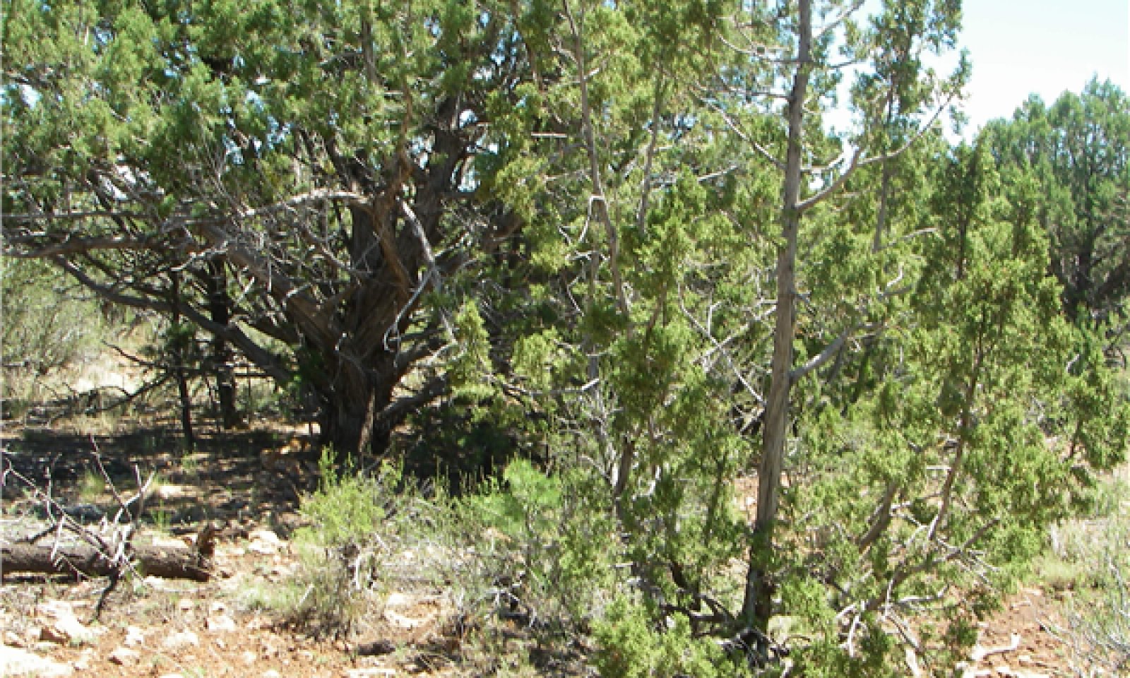
State 2
Alternative StateThis state is characterized by Pinyon-Juniper community affected by drought and Ips bark beetles. As a result of this disturbance, many of the pinyon pines have either died or are in serious decline. This site is dominated by juniper with evidence of dead pinyon pines on the site.
Community 2.1
Juniper with Pinyon Mortality
Figure 8. Pinyon-Juniper with Pinyon Mortality
This site is formerly Pinyon-Juniper but due to disturbance such as drought and insect damage most of the pinyon have died or are in serious decline. Junipers currently dominate.
Transition 1
State 1 to 2Transition from Reference State of Pinyon-Juniper to Alternative State of drought-stressed or dead Pinyon with Juniper dominating
Restoration pathway 1
State 2 to 1This Pathway back to the Reference State can be accomplished with removal of insect-infested dead wood, increased regular moisture, and possibly light ground fire although it has been shown that pinyon-juniper is not fire maintained.
Additional community tables
Table 6. Community 1.1 plant community composition
Group Common name Symbol Scientific name Annual production () Foliar cover (%) Table 7. Community 1.2 plant community composition
Group Common name Symbol Scientific name Annual production () Foliar cover (%) Tree1 Tree 15–350 oneseed juniper JUMO Juniperus monosperma 0–350 – twoneedle pinyon PIED Pinus edulis 15–350 – Utah juniper JUOS Juniperus osteosperma 0–144 – Shrub/Vine2 Shrub/Vine 0–70 Stansbury cliffrose PUST Purshia stansburiana 0–50 – alderleaf mountain mahogany CEMOM4 Cercocarpus montanus var. montanus 0–50 – broom snakeweed GUSA2 Gutierrezia sarothrae 0–25 – buckwheat ERIOG Eriogonum 0–20 – Grass/Grasslike3 Grass 20–200 blue grama BOGR2 Bouteloua gracilis 0–100 – squirreltail ELEL5 Elymus elymoides 0–75 – muttongrass POFE Poa fendleriana 20–50 – Canada wildrye ELCA4 Elymus canadensis 0–5 – sixweeks grama BOBA2 Bouteloua barbata 0–2 – Forb4 Forb 15–75 Table 8. Community 1.3 plant community composition
Group Common name Symbol Scientific name Annual production () Foliar cover (%) Table 9. Community 2.1 plant community composition
Group Common name Symbol Scientific name Annual production () Foliar cover (%) Interpretations
Supporting information
Type locality
Location 1: Coconino County, AZ UTM zone N UTM northing 3891907 UTM easting 452168 General legal description The type location for this site occurs on Walnut Canyon National Monument, with limited public access. Location 2: Coconino County, AZ UTM zone N UTM northing 3892468 UTM easting 459123 General legal description The type location for this site is located on Walnut Canyon and has limited public access. Contributors
Jennifer Puttere
Approval
Kendra Moseley, 5/19/2025
Rangeland health reference sheet
Interpreting Indicators of Rangeland Health is a qualitative assessment protocol used to determine ecosystem condition based on benchmark characteristics described in the Reference Sheet. A suite of 17 (or more) indicators are typically considered in an assessment. The ecological site(s) representative of an assessment location must be known prior to applying the protocol and must be verified based on soils and climate. Current plant community cannot be used to identify the ecological site.
Author(s)/participant(s) Jennifer Puttere Contact for lead author Flagstaff MLRA Soil Survey Office Date 03/05/2012 Approved by Approval date Composition (Indicators 10 and 12) based on Annual Production Indicators
-
Number and extent of rills:
There can be few to many rills on this site depending on the varying amount of rock fragments and on the presence or absence of cryptogamic crust. -
Presence of water flow patterns:
Generally no water patterns on this site. -
Number and height of erosional pedestals or terracettes:
No pedestals or terracettes. -
Bare ground from Ecological Site Description or other studies (rock, litter, lichen, moss, plant canopy are not bare ground):
No bare ground n this site. -
Number of gullies and erosion associated with gullies:
No gullies on this site -
Extent of wind scoured, blowouts and/or depositional areas:
No wind scoured, blowouts, or depositional areas. -
Amount of litter movement (describe size and distance expected to travel):
Litter movement is limited to 1 foot from point where dropped, both herbaceous and woody. -
Soil surface (top few mm) resistance to erosion (stability values are averages - most sites will show a range of values):
-
Soil surface structure and SOM content (include type of structure and A-horizon color and thickness):
-
Effect of community phase composition (relative proportion of different functional groups) and spatial distribution on infiltration and runoff:
-
Presence and thickness of compaction layer (usually none; describe soil profile features which may be mistaken for compaction on this site):
No compaction layer present on this site -
Functional/Structural Groups (list in order of descending dominance by above-ground annual-production or live foliar cover using symbols: >>, >, = to indicate much greater than, greater than, and equal to):
Dominant:
TreesSub-dominant:
Other:
Additional:
-
Amount of plant mortality and decadence (include which functional groups are expected to show mortality or decadence):
This site has high mortality of pinyon pines due to drought and subsequent insect damage. -
Average percent litter cover (%) and depth ( in):
-
Expected annual annual-production (this is TOTAL above-ground annual-production, not just forage annual-production):
<100 lb/acre expected production on this site. -
Potential invasive (including noxious) species (native and non-native). List species which BOTH characterize degraded states and have the potential to become a dominant or co-dominant species on the ecological site if their future establishment and growth is not actively controlled by management interventions. Species that become dominant for only one to several years (e.g., short-term response to drought or wildfire) are not invasive plants. Note that unlike other indicators, we are describing what is NOT expected in the reference state for the ecological site:
No invasive noxious species on this site. Occasional cactus (Echinocereus) may be found on this site which may or may not be considered invasive. -
Perennial plant reproductive capability:
Drought conditions have slowed the reproductive capacity and reduced the seedbank for pinyon as there has been high mortality on the site; herbaceous vegetation and juniper on-site are still capable of reproduction but with reduced capacity due to drought.
Print Options
Sections
Font
AAAAOther
PrintThe Ecosystem Dynamics Interpretive Tool is an information system framework developed by the USDA-ARS Jornada Experimental Range, USDA Natural Resources Conservation Service, and New Mexico State University.
Accessibility statement