Natural Resources
Conservation Service
-
Search


Major Land Resource Area or ecological site by name and/or ID.
PreviousSectionsNextGeneral information
Provisional. A provisional ecological site description has undergone quality control and quality assurance review. It contains a working state and transition model and enough information to identify the ecological site.
Click to explore map
Figure 1. Mapped extent
Areas shown in blue indicate the maximum mapped extent of this ecological site. Other ecological sites likely occur within the highlighted areas. It is also possible for this ecological site to occur outside of highlighted areas if detailed soil survey has not been completed or recently updated.
MLRA notes
Major Land Resource Area (MLRA): 035X–Colorado Plateau
Common Resource Area 35.5 – Grand Canyon Corridor
Elevations range from 1600 to 4500 feet and precipitation averages 6 to 10 inches per year. Extreme elevation and aspect changes make this area unique. Vegetation includes Mormon tea, catclaw, white brittlebush, blackbrush, prickly pear, cholla species, big galleta, and blue threeawn. The soil temperature regime ranges from thermic to mesic and the soil moisture regime is typic aridic. This unit occurs within the Colorado Plateau Physiographic Province and is characterized by extreme vertical escarpments and strong aspect differences over short distances. Sedimentary rock classes dominate the Grand Canyon and exposures consist of a thick sequence of relatively undeformed formations.Associated sites
R035XE502AZ Channery Hills 6-10" p.z.
Areas of mudstone/siltstone with no colluvium from geologic formations above.
R035XE504AZ Schist Hills 6-10" p.z.
Areas of intermixing of igneous formations such as Vishnu Schist.
Table 1. Dominant plant species
Tree Not specified
Shrub (1) Ephedra viridis
(2) Encelia farinosaHerbaceous (1) Pleuraphis rigida
(2) Pleuraphis jamesiiPhysiographic features
This ecological site occurs on the ledges and steep colluvial slopes of the cliffs and escarpments of various sedimentary formations. Soils are sandy loam and fine sandy loam, and range in depth from a few inches in pockets in the bedrock to deep on some steep slopes. This site occurs on all aspects, and the plant communities are significantly influenced by the strong relief and aspect changes. Slopes on some ledges are as low as 2 percent, but the typical slope range is 15 to 60 percent and can be much higher. Eolian sand deposits from 1/2 to 3 inches in depth, expecially in the wind corridors, are and important influence.
Table 2. Representative physiographic features
Landforms (1) Escarpment
(2) Scarp
(3) Canyon
Flooding frequency None Ponding frequency None Elevation 1600 – 4600 ft Slope 15 – 100 % Water table depth 60 – 72 in Aspect Aspect is not a significant factor Climatic features
The climate of the land resource unit is arid to semiarid with warm summers and cool winters. The mean annual precipitation ranges from 6 – 10 inches, but it is very erratic, often varying substantially from year to year. The majority of the precipitation falls during the between October through May. This precipitation comes as gentile rain or occasionally snow from frontal storms coming out to the Pacific Ocean. Snow is infrequent and rarely last more than 1-2 days. The remaining precipitation comes from July through September as spotty, unreliable and sometimes violent thunderstorms. The moisture for this precipitation originates in the Gulf of Mexico (and the Pacific Ocean in the fall) and flows into the area on the north end of the Mexican monsoon. Late May through late June is generally a dry period. The mean annual air temperature ranges from 55 to 69 degrees Fahrenheit (F). The frost-free period (air temperature > 32 degrees F) ranges from 180 to 220 days (@ 50 percent probability).
Table 3 Representative climatic features
Frost-free period (average) 200 days Freeze-free period (average) 220 days Precipitation total (average) 10 in BarLineFigure 2. Monthly precipitation range
BarLineFigure 3. Monthly average minimum and maximum temperature
">Influencing water features
Soil moisture on this ecological site if from precipitation. The bedrock on the site can concentrate moisture in areas with deeper soil pockets, increasing available soil moisture in those areas.
Soil features
Soil surface textures are sandy loam to loamy very fine sand and are very gravelly to extremely stony or channery. Soil depth can range from 4 to 60 inches, but is commonly 20 to 50 inches to bedrock. The surface can range from slightly to strongly effervescent. Soils may be slightly saline, depending on the influence of certain formations.
Soil Survey Map Unit Components Correlated to This Ecological Site:
Mohave County NE part (AZ625) Map units 65-Torriorthents;
Coconino County North Kaibab part (AZ629) Map Units 43-Torriorthents;
Hualapai-Havasupai Area (AZ699) Map Units 39 Torriorthents;
Grand Canyon Area (AZ701) Map Units 68 & 115 Lithic Torriorthents and 117 Typic torriorthents;
Little Colorado River Area (AZ707) Map Units 45-Lithic torriorthents Supai Group, 47-Lithic Torriorthents Hermit Formation, 48 Typic torriorthents Tonto Group Redwall Formation.Table 4. Representative soil features
Parent material (1) Colluvium – sandstone and shale
(2) Residuum – limestone and sandstone
Surface texture (1) Very gravelly sandy loam
(2) Extremely stony loamy very fine sand
(3) Extremely channery
Family particle size (1) Sandy
Drainage class Well drained Permeability class Moderate to moderately rapid Soil depth 4 – 60 in Surface fragment cover <=3" 20 – 0 % Surface fragment cover >3" 40 – 0 % Available water capacity
(0-40in)0 – 5 in Calcium carbonate equivalent
(0-40in)10 – 25 % Electrical conductivity
(0-40in)0 – 8 mmhos/cm Soil reaction (1:1 water)
(0-40in)7.9 – 8.4 Subsurface fragment volume <=3"
(Depth not specified)30 – 0 % Subsurface fragment volume >3"
(Depth not specified)50 – 0 % Ecological dynamics
The plant communities found on an ecological site are naturally variable. Composition and production will vary with yearly conditions, location, aspect, and the natural variability of the soils. The historical climax plant community represents the natural potential plant communities found on relict or relatively undisturbed sites. Other plant communities described here represent plant communities that are known to occur when the site is disturbed by factors such as grazing, fire, or drought.
Production data provided in this site description is standardized to air-dry weight at the end of the summer growing season. The plant communities described in this site description are based on near normal rainfall years.
NRCS uses a Similarity Index to compare existing plant communities to the plant communities described here. Similarity Index is determined by comparing the production and composition of a plant community to the production and composition of a plant community described in this site description. To determine Similarity Index, compare the production (air-dry weight) of each species to that shown in the plant community description. For each species, count no more than the maximum amount shown for the species, and for each group, count no more than the maximum shown for the group. Divide the resulting total by the total normal year production shown in the plant community description. If rainfall has been significantly above or below normal, use the total production shown for above or below normal years. If field data is not collected at the end of the summer growing season, then the field data must be corrected to the end of the year production before comparing it to the site description. The growth curve can be used as a guide for estimating production at the end of the summer growing season.State and transition model
Custom diagramStandard diagram
Figure 4. 355 SedimentaryCliffs S&T
More interactive model formats are also available. View Interactive Models
More interactive model formats are also available. View Interactive Models
Click on state and transition labels to scroll to the respective textEcosystem states
State 1 submodel, plant communities
State 2 submodel, plant communities
State 1
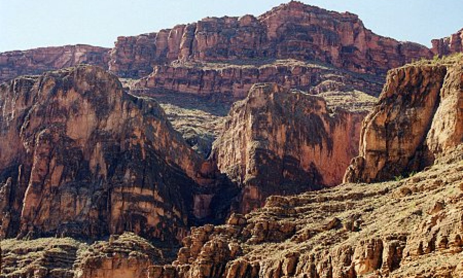
Reference StateCommunity 1.1
Historic Climax Plant Community
Figure 5. 355 SedimentaryCliffs
This community has a substantial shrub component that varies with aspect and the presence or absence of eolian sand. Exposed slopes can be very hot and dominated by white brittlebush, while cooler slopes have more grasses and ephedras and catclaw acacia. Areas with an eolian sand influence have significantly more warm season and cool season grasses (annual and perennial) than do areas with no sand influence.
Figure 6. Annual production by plant type (representative values) or group (midpoint values)
Table 5. Annual production by plant type
Plant type Low
(lb/acre)Representative value
(lb/acre)High
(lb/acre)Shrub/Vine 120 200 260 Grass/Grasslike 20 60 100 Forb 40 50 60 Total 180 310 420 State 2
Natives with Introduced Annuals StateCommunity 2.1
Native Shrub - Grass with Introduced Annuals CommunityThis community is similar to 1.1, but the introduced annuals such as red brome and Russian thistle. This plant community has a substantial shrub component that varies with aspect and the presence or absence of eolian sand. Exposed slopes can be very hot and dominated by white brittlebush, while cooler slopes have more grasses and ephedras and catclaw acacia. Areas with an eolian sand influence have significantly more warm season and cool season grasses (annual and perennial) than do areas with no sand influence. Introduced annuals are present in minor amounts.
Transition T1A
State 1 to 2Introduction of non-native annuals
Additional community tables
Table 6. Community 1.1 plant community composition
Group Common name Symbol Scientific name Annual production () Foliar cover (%) Grass/Grasslike1 Dominant Native perennial Summer Mid Grasses 15–50 James' galleta PLJA Pleuraphis jamesii 15–35 – big galleta PLRI3 Pleuraphis rigida 15–35 – bush muhly MUPO2 Muhlenbergia porteri 5–15 – 2 Occasional Native Perennial Summer Mid Grasses 5–15 Grass, perennial 2GP Grass, perennial 0–15 – cane bluestem BOBA3 Bothriochloa barbinodis 0–15 – sideoats grama BOCU Bouteloua curtipendula 0–15 – black grama BOER4 Bouteloua eriopoda 0–15 – spike dropseed SPCO4 Sporobolus contractus 0–15 – sand dropseed SPCR Sporobolus cryptandrus 0–15 – mesa dropseed SPFL2 Sporobolus flexuosus 0–15 – 3 Occasional NativePerennial Summer Short Grasses 0–10 Grass, perennial 2GP Grass, perennial 0–10 – Rothrock's grama BORO2 Bouteloua rothrockii 0–10 – red grama BOTR2 Bouteloua trifida 0–10 – low woollygrass DAPU7 Dasyochloa pulchella 0–10 – 4 Common Native Perennia Spring Mid Grasses 5–35 purple threeawn ARPU9 Aristida purpurea 0–10 – blue threeawn ARPUN Aristida purpurea var. nealleyi 0–10 – 5 Occasional Native Perennial Spring Mid Grasses 5–15 Grass, perennial 2GP Grass, perennial 0–15 – desert needlegrass ACSP12 Achnatherum speciosum 0–15 – needle and thread HECOC8 Hesperostipa comata ssp. comata 0–15 – New Mexico feathergrass HENE5 Hesperostipa neomexicana 0–15 – slim tridens TRMU Tridens muticus 0–15 – 6 Occasional Native Annual Grasses 5–35 Grass, annual 2GA Grass, annual 0–15 – sixweeks threeawn ARAD Aristida adscensionis 0–15 – sixweeks grama BOBA2 Bouteloua barbata 0–15 – muhly MUHLE Muhlenbergia 0–15 – panicgrass PANIC Panicum 0–15 – sixweeks fescue VUOC Vulpia octoflora 0–15 – Forb7 Occasional Native Perennial Spring Short Forbs 5–15 Forb, perennial 2FP Forb, perennial 0–15 – brownfoot ACWR5 Acourtia wrightii 0–15 – desert trumpet ERIN4 Eriogonum inflatum 0–15 – desert stingbush EUUR Eucnide urens 0–15 – desert pepperweed LEFR2 Lepidium fremontii 0–15 – roving sailor MAAN9 Maurandella antirrhiniflora 0–15 – phlox PHLOX Phlox 0–15 – globemallow SPHAE Sphaeralcea 0–15 – 8 Occasional Native Perennial Summer Short Forbs 5–15 Forb, perennial 2FP Forb, perennial 0–15 – trailing windmills ALIN Allionia incarnata 0–15 – Indian paintbrush CASTI2 Castilleja 0–15 – Colorado four o'clock MIMU Mirabilis multiflora 0–15 – goldenrod SOLID Solidago 0–15 – brownplume wirelettuce STPA4 Stephanomeria pauciflora 0–15 – 9 Occasional Native Annual Forbs 55–35 Forb, annual 2FA Forb, annual 0–5 – fiddleneck AMSIN Amsinckia 0–5 – white easterbonnets ANLA7 Antheropeas lanosum 0–5 – Crescent milkvetch ASAM5 Astragalus amphioxys 0–5 – Esteve's pincushion CHST Chaenactis stevioides 0–5 – thistle CIRSI Cirsium 0–5 – sacred thorn-apple DAWR2 Datura wrightii 0–5 – flatcrown buckwheat ERDE6 Eriogonum deflexum 0–5 – fleabane ERIGE2 Erigeron 0–5 – Texas stork's bill ERTE13 Erodium texanum 0–5 – spurge EUPHO Euphorbia 0–5 – shaggyfruit pepperweed LELA Lepidium lasiocarpum 0–5 – desertdandelion MALAC3 Malacothrix 0–5 – desert tobacco NIOB Nicotiana obtusifolia 0–5 – phacelia PHACE Phacelia 0–5 – yellow nightshade groundcherry PHCR4 Physalis crassifolia 0–5 – popcornflower PLAGI Plagiobothrys 0–5 – desert Indianwheat PLOV Plantago ovata 0–5 – woolly tidestromia TILA2 Tidestromia lanuginosa 0–5 – Shrub/Vine10 Common Native Half Shrubs 15–50 Subshrub (<.5m) 2SUBS Subshrub (<.5m) 0–10 – white sagebrush ARLU Artemisia ludoviciana 0–10 – dyssodia DYSSO Dyssodia 0–10 – starry bedstraw GAST Galium stellatum 0–10 – broom snakeweed GUSA2 Gutierrezia sarothrae 0–10 – lacy tansyaster MAPI Machaeranthera pinnatifida 0–10 – mountain phlox PHAU3 Phlox austromontana 0–10 – bush arrowleaf PLPL Pleurocoronis pluriseta 0–10 – slender poreleaf POGR5 Porophyllum gracile 0–10 – Coues' cassia SECO10 Senna covesii 0–10 – desert princesplume STPI Stanleya pinnata 0–10 – pricklyleaf dogweed THAC Thymophylla acerosa 0–10 – turpentinebroom THMO Thamnosma montana 0–10 – woody crinklemat TICA3 Tiquilia canescens 0–10 – matted crinklemat TILA6 Tiquilia latior 0–10 – goldeneye VIGUI Viguiera 0–10 – Mojave woodyaster XYTO2 Xylorhiza tortifolia 0–10 – 11 Dominant Native Shrubs 80–160 brittlebush ENFA Encelia farinosa 30–100 – Nevada jointfir EPNE Ephedra nevadensis 15–30 – Torrey's jointfir EPTO Ephedra torreyana 15–30 – mormon tea EPVI Ephedra viridis 15–30 – catclaw acacia ACGR Acacia greggii 5–30 – 12 Occasional Native Mid Shrubs 15–30 Shrub (>.5m) 2SHRUB Shrub (>.5m) 0–50 – Wright's beebrush ALWR Aloysia wrightii 0–50 – fourwing saltbush ATCA2 Atriplex canescens 0–50 – shadscale saltbush ATCO Atriplex confertifolia 0–50 – shortleaf baccharis BABR Baccharis brachyphylla 0–50 – sweetbush BEJU Bebbia juncea 0–50 – California brickellbush BRCA3 Brickellia californica 0–50 – netleaf hackberry CELAR Celtis laevigata var. reticulata 0–50 – button brittlebush ENFR Encelia frutescens 0–50 – Apache plume FAPA Fallugia paradoxa 0–50 – ocotillo FOSP2 Fouquieria splendens 0–50 – burrobrush HYSA Hymenoclea salsola 0–50 – water jacket LYAN Lycium andersonii 0–50 – Arizona desert-thorn LYEX Lycium exsertum 0–50 – mariola PAIN2 Parthenium incanum 0–50 – honey mesquite PRGL2 Prosopis glandulosa 0–50 – Fremont's dalea PSFR Psorothamnus fremontii 0–50 – skunkbush sumac RHTR Rhus trilobata 0–50 – purple sage SADO4 Salvia dorrii 0–50 – American threefold TRCA8 Trixis californica 0–50 – 13 Common Native Cacti 5–30 beavertail pricklypear OPBA2 Opuntia basilaris 0–15 – cactus apple OPEN3 Opuntia engelmannii 0–15 – plains pricklypear OPPO Opuntia polyacantha 0–15 – dollarjoint pricklypear OPCH Opuntia chlorotica 0–5 – Engelmann's hedgehog cactus ECEN Echinocereus engelmannii 0–5 – cottontop cactus ECPO2 Echinocactus polycephalus 0–5 – kingcup cactus ECTR Echinocereus triglochidiatus 0–5 – California barrel cactus FECY Ferocactus cylindraceus 0–5 – 14 Occasional Native Agave-Yucca-Like 5–15 Utah agave AGUT Agave utahensis 0–10 – sacahuista NOMI Nolina microcarpa 0–10 – narrowleaf yucca YUAN2 Yucca angustissima 0–10 – banana yucca YUBA Yucca baccata 0–10 – soaptree yucca YUEL Yucca elata 0–10 – Table 7. Community 2.1 plant community composition
Group Common name Symbol Scientific name Annual production () Foliar cover (%) Interpretations
Animal community
This is an important site for birds that utilize cliffs for nesting and cover. Other wildlife may utilize accessible areas of the site for food and cover. Bedrock outcroppings can hold puddles of water temporarily after rain events.
Hydrological functions
This site can be important in contributing run-on moisture to adjacent sites.
Recreational uses
This site is used for recreational rock climbing.
Wood products
This site does not produce wood products.
Supporting information
Type locality
Location 1: Coconino County, AZ Latitude 36° 26′ 5″ Longitude 111° 51′ 13″ General legal description In the interior of the Grand Canyon; 2,551 feet southwest of Tatahatso Wash; Other references
Updates and revisions for this ESD were conducted as part of a 2007-2012 Interagency Technical Assistance Agreement between the Bureau of Indian Affairs–Navajo Region and the NRCS-Arizona.
Contributors
Art Meen
Larry D. Ellicott
Stephen CassadyRangeland health reference sheet
Interpreting Indicators of Rangeland Health is a qualitative assessment protocol used to determine ecosystem condition based on benchmark characteristics described in the Reference Sheet. A suite of 17 (or more) indicators are typically considered in an assessment. The ecological site(s) representative of an assessment location must be known prior to applying the protocol and must be verified based on soils and climate. Current plant community cannot be used to identify the ecological site.
Author(s)/participant(s) Karlynn Huling Contact for lead author NRCS State Rangeland Management Specialist, Phoenix Az. Date 04/18/2006 Approved by Approval date Composition (Indicators 10 and 12) based on Annual Production Indicators
-
Number and extent of rills:
The soils on the site are variable. Till formation may be common in areas that have loam and sandy loam surface textures, moderate permeability, few surface rock fragments, rapid runoff, and very steep slopes. Rill formation is not likely in areas that have loamy sand surface textures, rapid to very rapid permeability, and a high cover of rock fragments, especially on the more gentle slopes. -
Presence of water flow patterns:
Soils on this site are variable. Water flow patterns may be common in areas that have moderate permeability, shallow depth, few surface rock fragments and very steep slopes. They are not likely in aeras with rapid to very rapid permeability, deeper soils, and a high cover of rock fragments, expecially on the more gentle slopes. -
Number and height of erosional pedestals or terracettes:
Some short pedestals and terracettes may form, but they will be limited by the amount of surface rock fragments. -
Bare ground from Ecological Site Description or other studies (rock, litter, lichen, moss, plant canopy are not bare ground):
This site should have no more than 40% bare ground. Areas with a greater cover of rock fragments and/or rock outcrop will have less bare ground. Drought may cause an increase in bare ground. -
Number of gullies and erosion associated with gullies:
None -
Extent of wind scoured, blowouts and/or depositional areas:
Soils on this site are variable. Most areas will not have any significant signs of wind erosion. Areas with loamy sand surfaces may ahve a few minor blowouts and depositional areas. -
Amount of litter movement (describe size and distance expected to travel):
Herbaceous and fine woody litter will be transported in water flow pathways and by wind. Most coarse woody litter will remain under shrub canopies, but somw will be transported in water flow pathways in the steepest areas. -
Soil surface (top few mm) resistance to erosion (stability values are averages - most sites will show a range of values):
Soil surface textures include loamy sands, sandy loam, fine sandy loam and loam. All surface horizons are very to extremely gravelly, channery, stony or bouldery. Most soils have a significant amount of rock fragments on the surface; the average is 20% gravels and 40% cobbles, channers, or stones. When well vegetated or covered with rock fragment armor, these soils have a low to high resistance to water erosion and a moderate to high resistance to wind erosion. -
Soil surface structure and SOM content (include type of structure and A-horizon color and thickness):
Soil surface structure may be subangular blocky (weak, fine), granular (moderate, fine), single grain, platy (weak, thin), or massive. Surface thickness range is 1-10 inches. Color is variable depending upon parent material. -
Effect of community phase composition (relative proportion of different functional groups) and spatial distribution on infiltration and runoff:
This site is characterized by a patchy distribution of mostly shrubs with some grass and a few forbs. Plant distribution is influenced by changes in soil (texture, depth, amount and size of rock fragments), hydrology (slope, position on the slope, amount of bedrock, cracking and weathering of the bedrock), and aspect across the site. Both plant cover values (canopy and basal) decrease during prolonged drought. -
Presence and thickness of compaction layer (usually none; describe soil profile features which may be mistaken for compaction on this site):
None. These soils are not easily compacted due to the extensive cover of rock fragment armor and the high volume of rock fragments within the surface horizon of the profile. -
Functional/Structural Groups (list in order of descending dominance by above-ground annual-production or live foliar cover using symbols: >>, >, = to indicate much greater than, greater than, and equal to):
Dominant:
shrubs >Sub-dominant:
warm season colonizing grasses >Other:
Minor: half shrubs = cool season bunchgrasses = warm season bunchgrasses > cacti = perennial forbs = annual forbs = annual grasses >Additional:
Trace: Agave family. -
Amount of plant mortality and decadence (include which functional groups are expected to show mortality or decadence):
All plant functional groups are adapted to survival in all years except the most severe droughts. Severe winter droughts affect shrubs the most. Severe summer droughts affect grasses the most. -
Average percent litter cover (%) and depth ( in):
Mostly woody litter with some herbaceous. Litter amounts increase during the first few years of drought, then decrease in later years. -
Expected annual annual-production (this is TOTAL above-ground annual-production, not just forage annual-production):
250-300 pounds per acre (dry weight) in dry years, 300-400 pounds per acre in median years, 400-450 pounds per acre in wet years. -
Potential invasive (including noxious) species (native and non-native). List species which BOTH characterize degraded states and have the potential to become a dominant or co-dominant species on the ecological site if their future establishment and growth is not actively controlled by management interventions. Species that become dominant for only one to several years (e.g., short-term response to drought or wildfire) are not invasive plants. Note that unlike other indicators, we are describing what is NOT expected in the reference state for the ecological site:
Access to and through this site may be extremely difficult. These conditions have preserved the native plant communities and biodiversity in most areas. More information is needed to determine which native or exotic species is capable of increaseing or dominating the site, especially in the more accessible areas. -
Perennial plant reproductive capability:
All plants native to the site are adapted to the climate and ae capable of producing seeds, stolons, and rhizomes in most years except for the most severe drougts.
Print Options
Sections
Font
AAAAOther
PrintThe Ecosystem Dynamics Interpretive Tool is an information system framework developed by the USDA-ARS Jornada Experimental Range, USDA Natural Resources Conservation Service, and New Mexico State University.
Accessibility statement