Natural Resources
Conservation Service
-
Search


Major Land Resource Area or ecological site by name and/or ID.
PreviousSectionsNextGeneral information
Provisional. A provisional ecological site description has undergone quality control and quality assurance review. It contains a working state and transition model and enough information to identify the ecological site.
Click to explore map
Figure 1. Mapped extent
Areas shown in blue indicate the maximum mapped extent of this ecological site. Other ecological sites likely occur within the highlighted areas. It is also possible for this ecological site to occur outside of highlighted areas if detailed soil survey has not been completed or recently updated.
MLRA notes
Major Land Resource Area (MLRA): 035X–Colorado Plateau
“PROVISIONAL ecological site concepts developed and described. See Project Plan [insert Project Plan Name] for more details and related milestones.”
This ecological site occurs in Land Resource Unit 35.2 - the Colorado Plateau Shrub – Grasslands
Elevations range from 3800-5800 feet and precipitation averages 6 to 10 inches per year. Vegetation includes shadscale, fourwing saltbush, Mormon tea, blackbrush, Indian ricegrass, galleta, blue grama, and black grama. The soil temperature regime is mesic and the soil moisture regime is typic aridic. This unit occurs within the Colorado Plateau Physiographic Province and is characterized by a sequence of flat to gently dipping sedimentary rocks eroded into plateaus, valleys and deep canyons. Sedimentary rock classes dominate the plateau with volcanic fields occurring for the most part near its margin.
Ecological site concept
“ATTENTION: This ecological site meets the requirements for PROVISIONAL (if not more). A provisional ecological site is established after ecological site concepts are developed and an initial state-and-transition model is drafted. A provisional ecological site typically will include literature reviews, land use history information, legacy data (prior approved range site descriptions, forage suitability groups, woodland suitability groups, etc.,) , and includes some soils data, and estimates for canopy and/or species composition by weight,. A provisional ecological site provides the conceptual framework of soil-site correlation for the development of the ESD. For more information about this ecological site, please contact your local NRCS office.”
Table 1. Dominant plant species
Tree (1) Populus fremontii
Shrub (1) Gutierrezia sarothrae
(2) Ericameria nauseosa ssp. consimilisHerbaceous (1) Distichlis spicata
(2) Sporobolus airoidesPhysiographic features
This site occurs in a bottom position along perennial or seasonal streams, and on spring fed section of streams where surface water is present throughout a significant portion of the growing season. Slopes are generally less than 2 percent but may be higher on bank slopes and in bedrock controlled sections.
Table 2. Representative physiographic features
Landforms (1) Flood plain
Flooding duration Long (7 to 30 days) to very long (more than 30 days) Flooding frequency Occasional to frequent Ponding duration Very brief (4 to 48 hours) to brief (2 to 7 days) Ponding frequency Occasional to frequent Elevation 3800 – 5800 ft Slope 0 – 2 % Water table depth 36 – 96 in Aspect Aspect is not a significant factor Climatic features
The climate of the land resource unit is arid with warm summers and cool winters. This is one of the driest land resource units on the Colorado Plateau with an average annual precipitation ranging from 6 to 10 inches per year. It is also very erratic, often varying substantially from year to year. 40 to 50 percent of the precipitation is received from October through early May. This precipitation comes as gentle rain or snow from frontal storms coming out of the Pacific Ocean. Snow is common from November through February. Generally no more than an inch or two of snow accumulates and usually melts within a day or two. The remaining precipitation, approximately 50 to 60 percent, is received from July through September as spotty, unreliable and sometimes violent thunderstorms. The moisture for this precipitation originates in the Gulf of Mexico (and the Pacific Ocean in the fall) and flows into the area on the north end of the Mexican monsoon. Late May through late June is generally a dry period. The mean annual temperature ranges from 53 to 56 degrees Fahrenheit (F). The frost-free period (air temperature > 32 degrees F) ranges from 135 to 160 days (@ 50 percent probability). Strong winds are common, especially in the spring.
Table 3 Representative climatic features
Frost-free period (average) 160 days Freeze-free period (average) 180 days Precipitation total (average) 10 in BarLineFigure 2. Monthly precipitation range
BarLineFigure 3. Monthly average minimum and maximum temperature
">Influencing water features
Soil features
The soils on this site are very deep (60+") and moderately well drained. They are formed in alluviuum from sandstone, granite and quartzite. Surface textures are generally fine sand to loamy sand. Subsurface textures include loamy fine sand, gravelly coarse sand and sand. There can be thin layers of loamy textures. Hazard of water erosion is none and hazard of wind erosion is severe.
Soil survey map unit components that have been correlated to this ecolgical site include:
SSA-618NM San Juan County eastern part 013- Beebe; Wr-Werlog; Wr-Walrees;
SSA-619 Chaco Canyon 03-Beebe; 013-Beebevar;
SSA-692NM MckKinley County 160-Beebevar;
SSA-707 Little Colorado River 7-Psammaquents/ Haplofibrists/Endoaquolls, 16-Bebeevar & Oxyaquic Torripsamment;
SSA-713 Chinle Area 42-Bebeevar, 51-Trail;
SSA-717NM Shiprock Area 142-Walrees, 142-Werlog;
Table 4. Representative soil features
Parent material (1) Alluvium – sandstone
Surface texture (1) Fine sand
(2) Loamy sand
(3) Sandy loam
Family particle size (1) Sandy
Drainage class Somewhat poorly drained to moderately well drained Permeability class Moderate to moderately rapid Soil depth 60 – 80 in Surface fragment cover <=3" 0 – 10 % Surface fragment cover >3" 0 – 25 % Available water capacity
(0-40in)0 – 2.5 in Calcium carbonate equivalent
(0-40in)1 – 5 % Electrical conductivity
(0-40in)2 – 4 mmhos/cm Sodium adsorption ratio
(0-40in)0 – 5 Soil reaction (1:1 water)
(0-40in)7.4 – 7.8 Subsurface fragment volume <=3"
(Depth not specified)0 – 40 % Subsurface fragment volume >3"
(Depth not specified)0 – 10 % Ecological dynamics
An ecological site is not a precise assemblage of species for which the proportions are the same from place to place or from year to year. In all plant communities, variability is apparent in productivity and occurrence of individual species. Spatial boundaries of the communities; however, can be recognized by characteristic patterns of species composition, association, and community structure. The historic climax plant community for this ecological site has been described by sampling relict or relatively undisturbed sites and/or reviewing historic records. The historic climax plant community is the plant community that evolved over time with the soil forming process and long term changes in climatic conditions of the area. It is the plant community that was best adapted to the unique combination of environmental factors associated with the site.
Natural disturbances, such as drought, fire, grazing of native fauna, and insects, are inherent in the development and maintenance of these plant communities. The effects of these disturbances are part of the range of characteristics of the ecological site. Fluctuations in plant community structure and function caused by the effects of natural disturbances help establish the boundaries and characteristics of an ecological site. They are accounted for as part of the range of characteristics of the ecological site. Recognizable plant community phases are identified in the reference state of the ecological site. Some sites may have a small range of variation, while others have a large range. Some plant community phases may exist for long periods of time, while others may only occur for a couple of years after a disturbance.
Deterioration of the plant community, hydrology, or soil site stability on an ecological site can result in crossing a threshold or potentially irreversible boundary to another state, or equilibrium. This can occur as a result of the loss of soil surface through erosion, the loss of the stability of the site due to disturbances that cause active erosion on the site, increases in the amounts and/or patterns or runoff from rainstorms, changes in availability of surface and subsurface water, significant changes in plant structural and functional types, or the introduction of non-native species. When these thresholds are crossed, the potential of the ecological site to return to the historic climax plant community can be lost, or restoration will require significant inputs . There may be multiple states possible for an ecological site, determined by the type and or severity of disturbance.
The known states and transition pathways for this ecological site are described in the state and transition model. Within each state, there may be one or more known plant community phases. These community phases describe the different plant community that can be recognized and mapped across this ecological site. The state and transition model is intended to help land users recognize the current plant community on the ecological site, and the management options for improving the plant community to the desired plant community.
Plant production information in this site description is standardized to the annual production on an air-dry weight basis in near normal rainfall years.
State and transition model
Custom diagramStandard diagram
More interactive model formats are also available. View Interactive Models
More interactive model formats are also available. View Interactive Models
Click on state and transition labels to scroll to the respective textEcosystem states
States 2, 5, 3 and 7 (additional transitions)
States 4, 7 and 8 (additional transitions)
States 6 and 9 (additional transitions)
State 1 submodel, plant communities
State 2 submodel, plant communities
State 3 submodel, plant communities
State 4 submodel, plant communities
State 5 submodel, plant communities
State 6 submodel, plant communities
State 7 submodel, plant communities
State 8 submodel, plant communities
State 9 submodel, plant communities
State 1
Historic Climax Plant CommunityCommunity 1.1
Historic Climax Plant Community
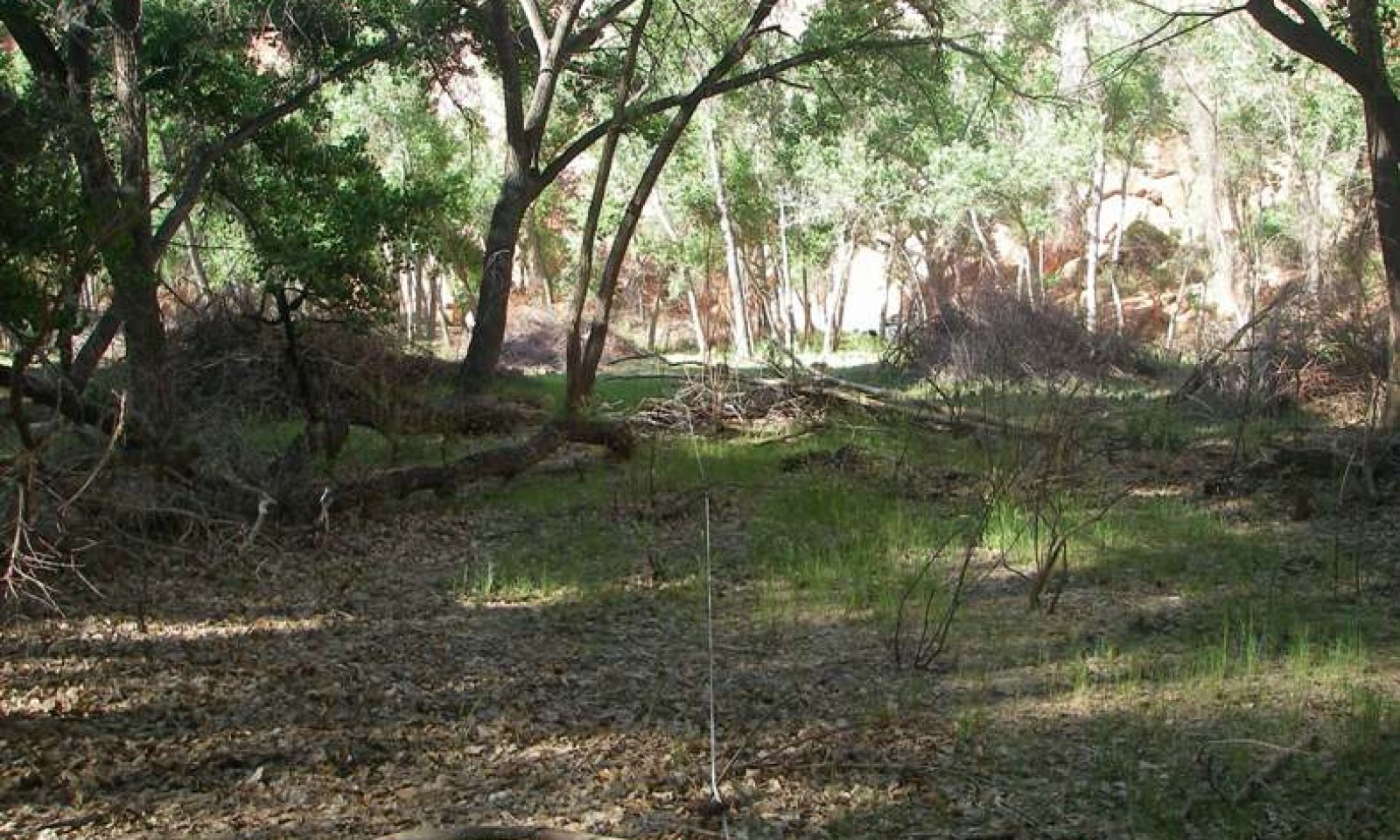
Figure 4. 35.2 Sandy Bottom
This site has a plant community made up primarily of mid grasses, shrubs and Fremont cottonwood trees. Forbs are a minor component of the site.
Plant species most likely to invade or increaswe on this site when it deteriorates are cheatgrass, annual weeds, threadleaf rubber rabbitbrush, tamarisk, Russian knapweed, camelthorn and Russian olive.Figure 5. Annual production by plant type (representative values) or group (midpoint values)
Table 5. Annual production by plant type
Plant type Low
(lb/acre)Representative value
(lb/acre)High
(lb/acre)Grass/Grasslike 825 900 975 Shrub/Vine 300 375 450 Tree 75 115 150 Forb 15 45 75 Total 1215 1435 1650 Figure 6. Plant community growth curve (percent production by month). AZ3521 , 35.2 6-10" p.z. all sites. Growth begins in the spring and continues through the summer. Most growth in this CRA occurs in the spring using stored winter moisture..
Jan Feb Mar Apr May Jun Jul Aug Sep Oct Nov Dec J F M A M J J A S O N D 0 1 9 20 27 14 10 11 5 3 0 0 Figure 7. Plant community growth curve (percent production by month). AZ5202 , Indian ricegrass, 35.2 6-10" p.z.. Growth begins in spring, most growth occurs in May, goes dormant during summer heat..
Jan Feb Mar Apr May Jun Jul Aug Sep Oct Nov Dec J F M A M J J A S O N D 0 0 10 15 40 20 0 0 10 5 0 0 Figure 8. Plant community growth curve (percent production by month). AZ5203 , 35.2 6-10" p.z. alkali sacaton. Growth begins in the spring, most growth occurs in the summer, goes dormant in the fall..
Jan Feb Mar Apr May Jun Jul Aug Sep Oct Nov Dec J F M A M J J A S O N D 0 0 5 10 20 10 20 20 10 5 0 0 State 2
Reference Plant CommunityExotic annual grasses and forbs have been introduced into the ecosystem. The overstory is dominated by cottonwoods and other native shrubs. The understory is made up of native grasses, forbs and shrubs with a few exotic annual grasses and forbs.
Community 2.1
Fremont cottonwood/desert saltgrass/alkali sacoton with exotic annualsThe overstory is dominated by cottonwoods and other native shrubs. The understory is made up of native grasses, forbs and shrubs with a few exotic annual grasses and forbs.
State 3
Exotic OverstoryExotic trees have been introduced into the ecosysteme. Saltcedar dominates the scattered overstory. Exotic annual grasses and forbs are mixed with native grasses and forbs in the understory.
Community 3.1
Exotic overstory with desert saltgrass/alkali sacoton with exotic annualsSaltcedar dominates the scattered overstory. Exotic annual grasses and forbs are mixed with native grasses and forbs in the understory.
State 4
Native Overstory with Understory Dominated by Exotic AnnualsCottonwoods and other native shrubs dominate the overstory. Exotic annual grasses dominate the understory.
Community 4.1
Native overstory with understory dominated by exotic annualsCottonwoods and other native shrubs dominate the overstory. Exotic annual grasses dominate the understory.
State 5
Native Overstory with Knapweed and/or CamelthronCottonwoods and other native shrubs dominate the overstory. Knapweed and exotic annual grasses dominate the understory.
Community 5.1
Native overstory w/ desert saltgrass/alkali sacaton w/ exotic annuals w/ knapweed and/or camelthornCottonwoods and other native shrubs dominate the overstory. Knapweed and/or camelthorn with exotic annual grasses dominate the understory.
State 6
Exotic Overstory with Knapweed and/or CamelthornSaltcedar and/or Russian Olive dominate the overstory. Knapweed and/or camelthorn and native and exotic grasses dominate the understory.
Community 6.1
Exotic overstory/desert saltgrass/alkali sacoton w/ exotic annuals w/ knapweed and/or camelthornSaltcedar and/or Russian Olive dominate the overstory. Knapweed and/or camelthorn and native and exotic grasses dominate the understory.
State 7
Exotic Overstory with Understory Dominated by Exotic AnnualsSalcedar and/or Russian olive dominate the overstory. Exotic annual grasses dominate the understory.
Community 7.1
Exotic overstory with understory dominated by exotic annualsSaltcedar and/or Russian olive dominate the overstory. Exotic annual grasses dominate the understory.
State 8
Native Overstory with Understory Dominated by Exotic Annuals with Knapweed and/or CamelthornCottonwoods and other native shrubs dominate the overstory. Knapweed and/or camelthorn and exotic grasses and forbs dominate the understory.
Community 8.1
Native overstory with understory dominated by exotic annuals with knapweed and/or camelthornCottonwoods and other native shrubs dominate the overstory. Knapweed and/or camelthorn and exotic grasses and forbs dominate the understory.
State 9
Exotic Overstory with Knapweed and/or Camelthorn with Understory Dominated by Exotic AnnualsSaltcedar and/or Russian olive dominate the scattered overstory. Knapweed and/or camelthorn with exotic annual grasses and forbs dominate the understory.
Community 9.1
Exotic overstory/knapweed and/or camelthorn with understory dominated by exotic annualsSaltcedar and/or Russian olive dominate the scattered overstory. Knapweed and/or camelthorn with exotic annual grasses and forbs dominate the understory.
Transition 1A
State 1 to 2Introduction of exotic annuals to the site.
Transition 2A
State 2 to 3Introduction of exotic overstory species to the site.
Transition 2B
State 2 to 4Continuous, extreme herbivory.
Transition 2C
State 2 to 5Introduction of knapweed and/or camelthorn to the site.
Restoration pathway 3A
State 3 to 2Remove exotic overstory.
Transition 3A
State 3 to 6Introduction of knapweed and/or camelthorn to the site.
Transition 3B
State 3 to 7Continuous, extreme herbivory.
Restoration pathway 4A
State 4 to 2continuous, extreme herbivory; control exotic annuals; replace native understory.
Transition 4A
State 4 to 7Introduction of exotic overstory species to the site.
Transition 4B
State 4 to 8Introduction of knapweed and/or camelthorn to the site.
Restoration pathway 5A
State 5 to 2Control of knapweed and/or camelthorn.
Transition 5B
State 5 to 6Introduction of exotic overstory species to the site.
Transition 5A
State 5 to 8Continuous, extreme herbivory.
Restoration pathway 6A
State 6 to 3Control of knapweed and/or camelthorn.
Restoration pathway 6B
State 6 to 5Remove exotic overstory.
Transition 6A
State 6 to 9Continuous, extreme herbivory.
Restoration pathway 7A
State 7 to 3Control of exotic annuals, replace native understory.
Restoration pathway 7B
State 7 to 4Remove exotic overstory.
Transition 7A
State 7 to 9Introduction of knapweed and/or camelthorn to the site.
Transition 8A
State 8 to 9Introduction of exotic overstory species to the site.
Restoration pathway 9A
State 9 to 7Control of knapweed and/or camelthorn.
Restoration pathway 9B
State 9 to 8Remove exotic overstory.
Additional community tables
Table 6. Community 1.1 plant community composition
Group Common name Symbol Scientific name Annual production () Foliar cover (%) Grass/Grasslike1 Grasses 825–975 saltgrass DISP Distichlis spicata 225–300 – alkali sacaton SPAI Sporobolus airoides 225–300 – Indian ricegrass ACHY Achnatherum hymenoides 75–150 – western wheatgrass PASM Pascopyrum smithii 0–75 – Grass, perennial 2GP Grass, perennial 0–75 – sand dropseed SPCR Sporobolus cryptandrus 15–75 – Grass, annual 2GA Grass, annual 0–50 – squirreltail ELELE Elymus elymoides ssp. elymoides 0–30 – Forb2 Forbs 15–75 Forb, perennial 2FP Forb, perennial 15–45 – Forb, annual 2FA Forb, annual 0–30 – Shrub/Vine3 Shrubs 300–450 rubber rabbitbrush ERNAC2 Ericameria nauseosa ssp. consimilis 20–100 – Shrub (>.5m) 2SHRUB Shrub (>.5m) 0–75 – broom snakeweed GUSA2 Gutierrezia sarothrae 20–60 – narrowleaf willow SAEX Salix exigua 0–50 – fourwing saltbush ATCA2 Atriplex canescens 0–50 – rubber rabbitbrush ERNAB2 Ericameria nauseosa ssp. nauseosa var. bigelovii 0–30 – stretchberry FOPUP Forestiera pubescens var. pubescens 0–30 – basin big sagebrush ARTRT Artemisia tridentata ssp. tridentata 0–30 – Tree4 Trees 75–150 Fremont cottonwood POFR2 Populus fremontii 75–150 – Table 7. Community 2.1 plant community composition
Group Common name Symbol Scientific name Annual production () Foliar cover (%) Table 8. Community 3.1 plant community composition
Group Common name Symbol Scientific name Annual production () Foliar cover (%) Table 9. Community 4.1 plant community composition
Group Common name Symbol Scientific name Annual production () Foliar cover (%) Table 10. Community 5.1 plant community composition
Group Common name Symbol Scientific name Annual production () Foliar cover (%) Table 11. Community 6.1 plant community composition
Group Common name Symbol Scientific name Annual production () Foliar cover (%) Table 12. Community 7.1 plant community composition
Group Common name Symbol Scientific name Annual production () Foliar cover (%) Table 13. Community 8.1 plant community composition
Group Common name Symbol Scientific name Annual production () Foliar cover (%) Table 14. Community 9.1 plant community composition
Group Common name Symbol Scientific name Annual production () Foliar cover (%) Interpretations
Animal community
This site is suitable for yearlong grazing by all classes of livestock. Prescribed Grazing systems adapt well to use on this site. When the inter-channel bars are in flood stage, it can be a hazard to livestock. Overgrazed areas will have wind erosion because of the high hazard.
This wetland site attracts many species of upland and wetland wildlife which use this site for nesting, feeding and resting. Competition with livestock can be high year round.Recreational uses
The Cottonwood trees, understory shrubs and grasses provide an aesthetically pleasing site on the low braided flood plains.
The winters are cold and spring time is usually windy. The summers are mild with typical southwest thunderstorms.
The main activities are birdwatching, wildlife observation and hunting.Supporting information
Type locality
Location 1: San Juan County, NM Township/Range/Section T30N R17W S33 General legal description Shiprock quad - about 3 miles east of Shiprock NM, north side of the San Juan River - Navajo Reservation, NM. Other references
Updates and revisions for this ESD were conducted as part of a 2007-2012 Interagency Technical Assistance Agreement between the Bureau of Indian Affairs–Navajo Region and the NRCS-Arizona.
Contributors
Harmon Hodgkinson
Karlynn Huling
Larry D. Ellicott
Peter Lefebvre
Steve CassadyRangeland health reference sheet
Interpreting Indicators of Rangeland Health is a qualitative assessment protocol used to determine ecosystem condition based on benchmark characteristics described in the Reference Sheet. A suite of 17 (or more) indicators are typically considered in an assessment. The ecological site(s) representative of an assessment location must be known prior to applying the protocol and must be verified based on soils and climate. Current plant community cannot be used to identify the ecological site.
Author(s)/participant(s) Kevin Williams Contact for lead author NRCS State Rangeland Management Specialist, Phoenix AZ Date 06/20/2007 Approved by Approval date Composition (Indicators 10 and 12) based on Annual Production Indicators
-
Number and extent of rills:
Rills are common within the annual floodplain due to frequent flooding. There are no rills on the floodplain ste due to moderately rapid permeabilty and high canopy and ground cover. -
Presence of water flow patterns:
Water flow patterns are common within the annual floodplain due to frequent flooding. There are no water flow patterns on the floodplain step due to moderately rapid permeability of the soils and high ground cover and low bare ground. -
Number and height of erosional pedestals or terracettes:
Erosional pedestals may be frequent around woody vegetation within the annual floodplain due to frequent flooding. There may be occasional erosional pedestals within the floodplain sep from past flood events, but these are not common due to the moderately rapid permeability of the soils and hevy cover by vegetation and litter. -
Bare ground from Ecological Site Description or other studies (rock, litter, lichen, moss, plant canopy are not bare ground):
Bare ground ranges from 90-100% (no canopy or ground cover) in the annual floodplain and from 5-15% in the floodplain step. -
Number of gullies and erosion associated with gullies:
None. The stream channels are only slightly entrenched, so the break between the annual floodplain and the floodplain step is usually subtle at best. There are no gullies within the floodplain step de to heavy ground cover by vegetation and litter. -
Extent of wind scoured, blowouts and/or depositional areas:
The soils within the annual floodplain are vulnerable to wind erosion when dry. There is little to no wind erosion within the floodplain step due to heavy ground cover by vegetation and litter -
Amount of litter movement (describe size and distance expected to travel):
Herbacous, fine woody and coarse woody litter will be transported throughout the site during periodic flood events, often forming litter dams within the annual floodplain and floodplain step. -
Soil surface (top few mm) resistance to erosion (stability values are averages - most sites will show a range of values):
Soil surface texture aresandy loams, ranging from sandy loam to fine sandy loam. Coarse fragments are not common. When well vegetated and not subjected to severe flood events, the soils have a low to moderate resistnce to water erosion and a moderate to high resistance to wind erosion. -
Soil surface structure and SOM content (include type of structure and A-horizon color and thickness):
Soil surface structure is mostly coarse granular to massive. The A-horizon is 2-6 inches thick. The color of the A-horizon shows moderate darkening over the subsurface soil horizons below it. -
Effect of community phase composition (relative proportion of different functional groups) and spatial distribution on infiltration and runoff:
This site is characterized by an overstory of trees and an understory of relatively equal distribution of grasses and forbs. Biological crusts are scarce due to frequent flooding of the annual floodplain and heavy canopy cover on the floodplain step. Canop cover in the annual floodplain ranges frm 0-10%. Canopy cover in the floodplain step ranges from 70-90% (trees > grasses > forbs). Basal cover ranges 5-10% (predominantly grasses) for vascular plants and 0-% for biological crust (moss > liche > cyanobacteria). Within the annual floodplain and on the floodplain step, canopy and basal cover values may decrease for a few years after a significant flood event, but would return to pre-flood levels within a few years provided another flood event does not occur. This type of plant community is not effective at capturing and storing precipitation on the annual floodplain. It is highly effective at capturing and storing precipitation on the floodplain step. -
Presence and thickness of compaction layer (usually none; describe soil profile features which may be mistaken for compaction on this site):
None. Most of the soils are not easily compacted. Many of the soils have a naturally granular strucure. -
Functional/Structural Groups (list in order of descending dominance by above-ground annual-production or live foliar cover using symbols: >>, >, = to indicate much greater than, greater than, and equal to):
Dominant:
shrubs (includin SAEX) >>Sub-dominant:
treesOther:
Additional:
Floodplain step: trees >> shrubs (including SAEX) > colonizing grasses > cool season bunchgrasses > perennial forbs > annual forbs = annual grasses -
Amount of plant mortality and decadence (include which functional groups are expected to show mortality or decadence):
All plant functional groups are adapted to survival in all but the most severe droughts. The shallow water table mitigates some of the effects of drought on the site. Severe winter droughts ffect shrubs and trees the most. Severe summer droughts affect grasses the most. -
Average percent litter cover (%) and depth ( in):
Of the total litter amount, it would be expected that approximately 10-20% would be herbaceous litter and approximately 80-90% would be woodylitter on the annual floodplain, and approximately 70-90 would be herbaceous litter and approximately 10-30% would be wooy ltter on the floodplain step. -
Expected annual annual-production (this is TOTAL above-ground annual-production, not just forage annual-production):
1000-1500 lbs/ac in drought years; 1500-2500 lbs/ac median years, 2500-3500 in wet years. -
Potential invasive (including noxious) species (native and non-native). List species which BOTH characterize degraded states and have the potential to become a dominant or co-dominant species on the ecological site if their future establishment and growth is not actively controlled by management interventions. Species that become dominant for only one to several years (e.g., short-term response to drought or wildfire) are not invasive plants. Note that unlike other indicators, we are describing what is NOT expected in the reference state for the ecological site:
Kentucky bluegrass, ripgut brome, chatgrass and smooth barley are exotic grasses that have the potential to invade and dominate the site, especially after heavy grazing and/or disturbance. Black medic is an exotic forb hat has the potential to invade and dominate the site after heavy grazing and/or disturbance. Salt cedar and Russian olive are exotic trees and Russian knapweed is an exotic forb that have the potential to invade and dominate the site, with or without grazing. -
Perennial plant reproductive capability:
All native plants to the site are adapted to the climate and are capable of producing seeds, stolons and/or rhizomes except during the most severe droughts.
Print Options
Sections
Font
AAAAOther
PrintThe Ecosystem Dynamics Interpretive Tool is an information system framework developed by the USDA-ARS Jornada Experimental Range, USDA Natural Resources Conservation Service, and New Mexico State University.
Accessibility statement