Natural Resources
Conservation Service
-
Search


Major Land Resource Area or ecological site by name and/or ID.
PreviousSectionsNextGeneral information
Provisional. A provisional ecological site description has undergone quality control and quality assurance review. It contains a working state and transition model and enough information to identify the ecological site.
Click to explore map
Figure 1. Mapped extent
Areas shown in blue indicate the maximum mapped extent of this ecological site. Other ecological sites likely occur within the highlighted areas. It is also possible for this ecological site to occur outside of highlighted areas if detailed soil survey has not been completed or recently updated.
MLRA notes
Major Land Resource Area (MLRA): 035X–Colorado Plateau
This ecological site occurs in Common Resource Area 35.6 - the Colorado Plateau Pinyon-Juniper-Sagebrush
The Common Resource Area occurs within the Colorado Plateau Physiographic Province. Elevations range from 5800 to 7300 feet and precipitation averages 13 to 17 inches per year. Vegetation includes pinyon, juniper, big sagebrush, cliffrose, Mormon tea, muttongrass, prairie junegrass, squirreltail, western wheatgrass, and blue grama. The soil temperature regime is mesic and the soil moisture regime is aridic ustic. This unit occurs within the Colorado Plateau Physiographic Province and is characterized by a sequence of flat to gently dipping sedimentary rocks eroded into plateaus, valleys and deep canyons. Sedimentary rock classes dominate the plateau with volcanic fields occurring for the most part near its margin.
Associated sites
R035XF601AZ Sedimentary Cliffs 13-17" p.z.
This site is located on cliff faces and talus slopes above the referenced site.
R035XF606AZ Sandy Loam Upland 13-17" p.z.
This site is located on upper stream terraces above the referenced site.
Similar sites
F035XC332AZ Sandy Bottom 10-14" (PODEW, SAEX), Perennial (Provisional)
This site has similar dominant vegetation as the referenced site, but is found in CRA 35-3. It may be located downstream from the referenced site.
Table 1. Dominant plant species
Tree (1) Populus deltoides ssp. wislizeni
Shrub (1) Salix exigua
Herbaceous Not specified
Physiographic features
This site occurs on floodplains and low floodplain steps of perennial or intermittent streams with perennial subsurface flows. The site receives additional moisture from occasional, very brief periods of flooding. Depth to a seasonal high water table is 0 to 40 inches that also benefits the site. Slopes generally range from 0-5%.
Table 2. Representative physiographic features
Landforms (1) Flood plain
(2) Bar
(3) Flood-plain step
Flooding duration Very brief (4 to 48 hours) to brief (2 to 7 days) Flooding frequency Occasional to frequent Ponding frequency None Elevation 5800 – 7300 ft Slope 0 – 5 % Water table depth 0 – 40 in Aspect Aspect is not a significant factor Climatic features
The climate of this land resource unit is semiarid with warm summers and cool winters. The mean annual precipitation ranges from 13 – 17 inches, but it is very erratic, often varying substantially from year to year. The majority of the precipitation comes from October through April. This precipitation comes as gentle rain or snow from frontal storms coming out of the Pacific Ocean. Snow is common from November through February. Generally no more than a few inches of snow accumulates, melting within a few days, but may last a week or more. The remaining precipitation comes from July through September as spotty, unreliable and sometimes violent thunderstorms. The moisture for this precipitation originates in the Gulf of Mexico (and the Pacific Ocean in the fall) and flows into the area on the north end of the Mexican monsoon. Late May through late June is generally a dry period. The mean annual air temperature ranges from 47 to 49 degrees Fahrenheit (F). The frost-free period (air temperature > 32 degrees F) ranges from 113 to 144 days (at 50 percent probability). Strong winds are common, especially in the spring.
Table 3 Representative climatic features
Frost-free period (average) 140 days Freeze-free period (average) 160 days Precipitation total (average) 20 in BarLineFigure 2. Monthly precipitation range
BarLineFigure 3. Monthly average minimum and maximum temperature
">Influencing water features
The natural stream type for this site was most likely a Rosgen type “E” channel. Historic photographic evidence shows that the streams within this site were Rosgen type “D” channels at the turn of this century. That is they have slopes less than 4%, were braided with high bedloads and bank erosion. Stream channels were wide and relatively shallow.
Soil features
The soils are very deep and moderately well drained. They are formed in alluvium derived from sandstone, granite and quartzite. Surface textures include fine sandy loam to loam. Subsurface textures include very gravelly loamy sand, loamy sand, and fine sandy loam. Stratified layers below 40 inches may have greater then 35% rock fragments and more than 15% clay. Hazard of water erosion is moderate to high and hazard of wind erosion is moderate to high. Soil surface rock fragments are uncommon unless the surface has eroded to a coarse alluvial layer. Rock fragments are more common on surface of active stream channel.
Soil survey map unit components correlated to this ecological site include;
SSA-712 Canyon de Chelly National Monument MU 21, Yaggy Family;
SSA-713 Chinle Area MU's 36 Oxyaquic haplostolls.Table 4. Representative soil features
Parent material (1) Alluvium – sandstone
Surface texture (1) Fine sandy loam
(2) Loam
Family particle size (1) Sandy
Drainage class Moderately well drained Permeability class Moderate to rapid Soil depth 70 – 100 in Surface fragment cover <=3" 0 – 10 % Surface fragment cover >3" 0 – 5 % Available water capacity
(0-40in)4.4 in Calcium carbonate equivalent
(0-40in)0 – 5 % Soil reaction (1:1 water)
(0-40in)7.4 – 8.4 Subsurface fragment volume <=3"
(Depth not specified)0 – 20 % Subsurface fragment volume >3"
(Depth not specified)0 – 10 % Ecological dynamics
An ecological site is not a precise assemblage of species for which the proportions are the same from place to place or from year to year. In all plant communities, variability is apparent in productivity and occurrence of individual species. Spatial boundaries of the communities; however, can be recognized by characteristic patterns of species composition, association, and community structure. The historic climax plant community for this ecological site has been described by sampling relict or relatively undisturbed sites and/or reviewing historic records. The historic climax plant community is the plant community that evolved over time with the soil forming process and long term changes in climatic conditions of the area. It is the plant community that was best adapted to the unique combination of environmental factors associated with the site.
Natural disturbances, such as drought, fire, grazing of native fauna, and insects, are inherent in the development and maintenance of these plant communities. The effects of these disturbances are part of the range of characteristics of the ecological site. Fluctuations in plant community structure and function caused by the effects of natural disturbances help establish the boundaries and characteristics of an ecological site. They are accounted for as part of the range of characteristics of the ecological site. Recognizable plant community phases are identified in the reference state of the ecological site. Some sites may have a small range of variation, while others have a large range. Some plant community phases may exist for long periods of time, while others may only occur for a couple of years after a disturbance.
Deterioration of the plant community, hydrology, or soil site stability on an ecological site can result in crossing a threshold or potentially irreversible boundary to another state, or equilibrium. This can occur as a result of the loss of soil surface through erosion, the loss of the stability of the site due to disturbances that cause active erosion on the site, increases in the amounts and/or patterns or runoff from rainstorms, changes in availability of surface and subsurface water, significant changes in plant structural and functional types, or the introduction of non-native species. When these thresholds are crossed, the potential of the ecological site to return to the historic climax plant community can be lost, or restoration will require significant inputs . There may be multiple states possible for an ecological site, determined by the type and or severity of disturbance.
The known states and transition pathways for this ecological site are described in the state and transition model. Within each state, there may be one or more known plant community phases. These community phases describe the different plant community that can be recognized and mapped across this ecological site. The state and transition model is intended to help land users recognize the current plant community on the ecological site, and the management options for improving the plant community to the desired plant community.
Plant production information in this site description is standardized to the annual production on an air-dry weight basis in near normal rainfall years.
State and transition model
Custom diagramStandard diagram
Figure 4. 35.6 Loamy bottom
More interactive model formats are also available. View Interactive Models
More interactive model formats are also available. View Interactive Models
Click on state and transition labels to scroll to the respective textEcosystem states
State 1 submodel, plant communities
State 2 submodel, plant communities
State 3 submodel, plant communities
State 1
Reference StateThe overstory is dominated by Rio Grande cottonwood and other native shrubs. The understory is comprised of a sparse mix of native grasses, shrubs and forbs. Occasional flooding is important for establishment and maintenance of cottonwood and willows along the streambanks. Fire is not common on this site due to the moist nature of the soils and vegetation, but may occur in rare events.
Community 1.1
Historic Climax Plant Community
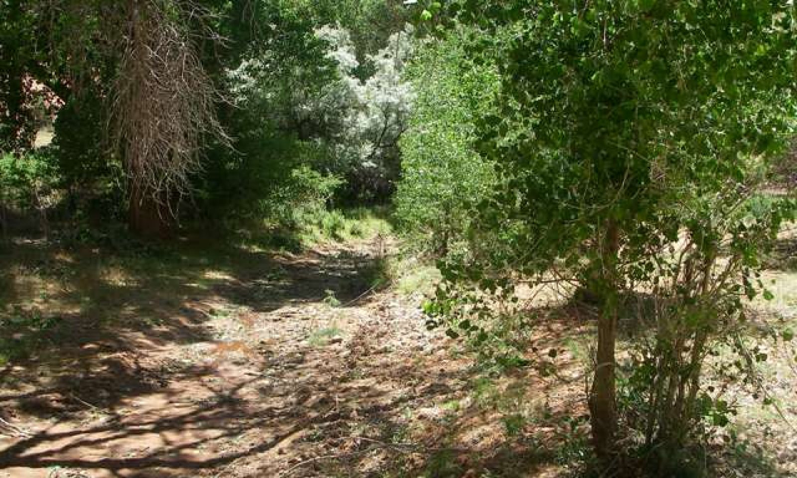
Figure 5. 35.6 Loamy Bottom 13-17 " p.z.
The Historic Climax Plant Community (HCPC) is dominated by a canopy of cottonwood and willow, with an understory of young cottonwood, willow, and other shrubs, and a sparse herbaceous understory of cool-season grasses, rushes and forbs. Overstory canopy cover ranges from 25-80% with an average of around 50% and fluctuates with flood events under natural conditions. These fluctuations allow gaps in the canopy that are important for the recruitment of young cottonwoods and willows into the overstory.
Forest overstory.The overstory is comprised primarily of Rio Grande cottonwood (Populus deltoides ssp. wislizenii) with lesser amounts of native willows, boxelder and narrowleaf cottonwood.
Forest understory. The understory is comprised primarily of coyote willow (Salix exigua). Other riparian shrubs are present, such as redosier dogwood (Cornus sericea) and chokecherry (Prunus spp.). Hrbaceous species include grasses, rushes and forbs.
Figure 6. Annual production by plant type (representative values) or group (midpoint values)
Table 5. Annual production by plant type
Plant type Low
(lb/acre)Representative value
(lb/acre)High
(lb/acre)Tree 350 710 1150 Shrub/Vine 50 150 250 Grass/Grasslike 25 75 150 Forb 25 85 125 Total 450 1020 1675 Table 6. Ground cover
Tree foliar cover 60-90% Shrub/vine/liana foliar cover 0-10% Grass/grasslike foliar cover 0-10% Forb foliar cover 0-10% Non-vascular plants 0-0% Biological crusts 0-0% Litter 0-10% Surface fragments >0.25" and <=3" 0-10% Surface fragments >3" 0-10% Bedrock 0% Water 0% Bare ground 10-20% Table 7. Soil surface cover
Tree basal cover 0-0% Shrub/vine/liana basal cover 0-0% Grass/grasslike basal cover 0-0% Forb basal cover 0-0% Non-vascular plants 0-0% Biological crusts 0-0% Litter 40-60% Surface fragments >0.25" and <=3" 0-10% Surface fragments >3" 0-10% Bedrock 0% Water 0% Bare ground 30-50% Figure 7. Plant community growth curve (percent production by month). AZ3561 , 35.6 13-17" p.z. all sites. Growth begins in the spring and continues into the fall..
Jan Feb Mar Apr May Jun Jul Aug Sep Oct Nov Dec J F M A M J J A S O N D 0 1 5 16 17 15 15 15 11 5 0 0 Community 1.2
Riparian Shrub/ Tree CommunityThe overstory is dominated by Coyote willow. There may be some mature and decadent cottonwood and other willows in the community, but they do not dominate the overstory. There is an understory of willow, cottonwood, chokecherry and other shrubs. There are scattered cool-season grasses, rushes and forbs in the understory.
Pathway 1.1A
Community 1.1 to 1.2Severe flood or fire, unmanaged grazing.
Pathway 1.2A
Community 1.2 to 1.1Managed grazing and stabilized flood regimes.
State 2
Natives with Introduced Annual StateCottonwoods and other native shrubs dominate the overstory. Exotic annual grasses are present in the understory but the amount of native perennial grasses remains relatively unchanged.
Community 2.1
Riparian Forest with Non-Native HerbaceousThis community is dominated by a canopy of cottonwood and willow, with an understory of young cottonwood, willow, and other shrubs, and a sparse herbaceous understory of cool-season grasses, such as slender wheatgrass and dropseeds, mixed with non-native grasses and forbs. Overstory canopy cover can come close to 90 percent, but would fluctuate with flood events under natural conditions.
State 3
Native and Introduced Tree/Shrub StateSaltcedar and/or Russian olive dominate or co-dominate the overstory with native trees. Native shrubs and grasses can occur in the understory, but non-native annuals are dominant.
Community 3.1
Native/ Non-Native Riparian TreeRio Grande cottonwood and willows co-dominate the overstory with non-native tree species such as saltcedar (Tamarix chinensis) and Russian olive (Eleagnus angustifolia). The herbaceous understory consists of native shrubs with some native grasses and forbs, but primarily non-native grasses and forbs, including ripgut brome (Bromus diandrus), cheatgrass (Bromus tectorum) and Kentucky bluegrass (Poa pratensis).
Community 3.2
Non-Native Riparian TreeRussian olive (Eleagnus angustifolia) and/or saltcedcar (Tamarix chinensis) dominate the overstory. Native willows may be present in lesser amoutns. The herbaceous understory consists of native shrubs with non-native grasses and forbs, including ripgut brome (Bromus diandrus), cheatgrass (Bromus tectorum) and Kentucky bluegrass (Poa pratensis).
Pathway 3.1A
Community 3.1 to 3.2Increased fire frequency, drought, unmanaged grazing.
Pathway 3.2A
Community 3.2 to 3.1Mechanical and/or herbicide treatments for non-native woody and herbaceous species, managed grazing, reseeding/planting native species.
Transition T1A
State 1 to 2Unmanaged grazing, drought, non-native species such as cheatgrass and ripgut brome are introduced into the site.
Transition T1B
State 1 to 3Unmanaged grazing, drought, saltcedar and/or Russian olive and annuals such as cheatgrass and ripgut brome are introduced to the site.
Transition T2A
State 2 to 3Significant disturbances, unmanaged grazing, severe flood event or fire favors non-native annual grasses and forbs. Saltcedar and/or Russian olive are introduced to the site.
Restoration pathway R2A
State 3 to 2Mechanical and/or herbicide treatments for non-native woody and herbaceous species, managed grazing, reseeding/planting native species.
Additional community tables
Table 8. Community 1.1 plant community composition
Group Common name Symbol Scientific name Annual production () Foliar cover (%) Grass/Grasslike1 Perennial Rhizomatous Grass 20–120 slender wheatgrass ELTRT Elymus trachycaulus ssp. trachycaulus 20–100 – mountain rush JUARL Juncus arcticus ssp. littoralis 1–20 – Mexican rush JUME4 Juncus mexicanus 1–20 – 2 Perennial Bunchgrass 1–20 sand dropseed SPCR Sporobolus cryptandrus 5–20 – foxtail barley HOJU Hordeum jubatum 1–5 – 3 Perennial Warm Season Rhizomatous Grass 1–10 scratchgrass MUAS Muhlenbergia asperifolia 1–10 – 4 Annual Grasses 1–5 sixweeks grama BOBA2 Bouteloua barbata 1–5 – mouse barley HOMU Hordeum murinum 1–5 – sixweeks fescue VUOC Vulpia octoflora 1–5 – Forb5 Perennial Forbs 20–60 white sagebrush ARLU Artemisia ludoviciana 1–20 – thistle CIRSI Cirsium 1–10 – horsetail EQUIS Equisetum 1–10 – ragwort SENEC Senecio 1–10 – water speedwell VEAN2 Veronica anagallis-aquatica 1–10 – fleabane ERIGE2 Erigeron 1–5 – milkvetch ASTRA Astragalus 1–5 – common yarrow ACMI2 Achillea millefolium 1–5 – 6 Annual Forbs 20–80 flatspine bur ragweed AMAC2 Ambrosia acanthicarpa 1–5 – sandmat CHAMA15 Chamaesyce 1–5 – Rocky Mountain beeplant CLSE Cleome serrulata 1–5 – American bugseed COAMA2 Corispermum americanum var. americanum 1–5 – Canadian horseweed COCA5 Conyza canadensis 1–5 – Texas croton CRTE4 Croton texensis 1–5 – western tansymustard DEPI Descurainia pinnata 1–5 – wedgeleaf draba DRCUC Draba cuneifolia var. cuneifolia 1–5 – redstem stork's bill ERCI6 Erodium cicutarium 1–5 – kiss me quick POPI3 Portulaca pilosa 1–5 – globemallow SPHAE Sphaeralcea 1–5 – dandelion TARAX Taraxacum 1–5 – golden crownbeard VEENE2 Verbesina encelioides ssp. exauriculata 1–5 – Shrub/Vine7 Dominant Shrubs 100–200 narrowleaf willow SAEX Salix exigua 100–200 – 8 Other Tall Shrubs 5–25 redosier dogwood COSES Cornus sericea ssp. sericea 5–25 – chokecherry PRVI Prunus virginiana 5–25 – Woods' rose ROWO Rosa woodsii 5–15 – 9 Halfshrubs 5–25 hairy false goldenaster HEVI4 Heterotheca villosa 5–25 – Tree10 Trees 0–1150 Rio Grande cottonwood PODEW Populus deltoides ssp. wislizeni 200–600 – narrowleaf cottonwood POAN3 Populus angustifolia 0–200 – narrowleaf willow SAEX Salix exigua 100–200 – boxelder ACNE2 Acer negundo 0–200 – Goodding's willow SAGO Salix gooddingii 50–100 – arroyo willow SALA6 Salix lasiolepis 50–100 – peachleaf willow SAAM2 Salix amygdaloides 50–100 – Gambel oak QUGA Quercus gambelii 0–50 – Rocky Mountain juniper JUSC2 Juniperus scopulorum 0–50 – Table 9. Community 1.2 plant community composition
Group Common name Symbol Scientific name Annual production () Foliar cover (%) Table 10. Community 2.1 plant community composition
Group Common name Symbol Scientific name Annual production () Foliar cover (%) Table 11. Community 3.1 plant community composition
Group Common name Symbol Scientific name Annual production () Foliar cover (%) Table 12. Community 3.2 plant community composition
Group Common name Symbol Scientific name Annual production () Foliar cover (%) Interpretations
Animal community
This site is suitable for grazing by livestock and wildlife during most of the grazing periods except when snow cover restricts availability of forage. Grazing must be managed to allow for periodic reproduction of cottonwood and willow species. Seeds germinate in beds of alluvium left after spring or summer floods. Spring seedlings require one full season to grow out of reach of grazing stock. Summer seedlings may require two seasons to reach a height where the terminal bud is out of reach. Seedlings of both species are very palatable to cattle.
This wetland site attracts many species of upland and wetland wildlife Which use this site for nesting, feeding and resting. Competition with livestock can be year-round.
The "Plant Preference By Animal Kind" Table Information below was compiled from information from similar riparian sites in Arizona and a summary table compiled for all sites in MLRA 35 in Utah.
Hydrological functions
This site is very important in the hydrology of southwestern stream systems. Large amounts of coarse woody debris form dams in large floods and spread waters over the floodplain. Beavers helped maintain a mosaic of marshy areas. Dense vegetation shade floodplains and stream channels to reduce evaporation. Vegetation traps sediment improving water quality and building floodplains.
Recreational uses
The cottonwood trees, understory shrubs and grasses, and perennial or intermittent stream beds provide an aesthetically pleasing site on the low floodplains.
The winters are cold and the springs tend to be dry and windy. Late spring, summer and fall are the most pleasant seasons for outdoor activities such as bird watching, wildlife observation, hunting, and camping.
Wood products
The value of this plant community for wildlife is many times greater than its value for wood products. Cutting should be limited to flood damaged and fallen trees and driftwood.
Table 13. Representative site productivity
Common name Symbol Site index low Site index high CMAI low CMAI high Age of CMAI Site index curve code Site index curve basis Citation Rio Grande cottonwood PODEW 130 150 75 100 – – – Supporting information
Type locality
Location 1: Coconino County, AZ UTM zone N UTM northing 4133947 UTM easting 977005 Other references
Updates and revisions for this ESD were conducted as part of a 2007-2012 Interagency Technical Assistance Agreement between the Bureau of Indian Affairs–Navajo Region and the NRCS-Arizona.
Contributors
Dan Carroll
Kevin Williams
Larry D. EllicottRangeland health reference sheet
Interpreting Indicators of Rangeland Health is a qualitative assessment protocol used to determine ecosystem condition based on benchmark characteristics described in the Reference Sheet. A suite of 17 (or more) indicators are typically considered in an assessment. The ecological site(s) representative of an assessment location must be known prior to applying the protocol and must be verified based on soils and climate. Current plant community cannot be used to identify the ecological site.
Author(s)/participant(s) Contact for lead author Date Approved by Approval date Composition (Indicators 10 and 12) based on Annual Production Indicators
-
Number and extent of rills:
-
Presence of water flow patterns:
-
Number and height of erosional pedestals or terracettes:
-
Bare ground from Ecological Site Description or other studies (rock, litter, lichen, moss, plant canopy are not bare ground):
-
Number of gullies and erosion associated with gullies:
-
Extent of wind scoured, blowouts and/or depositional areas:
-
Amount of litter movement (describe size and distance expected to travel):
-
Soil surface (top few mm) resistance to erosion (stability values are averages - most sites will show a range of values):
-
Soil surface structure and SOM content (include type of structure and A-horizon color and thickness):
-
Effect of community phase composition (relative proportion of different functional groups) and spatial distribution on infiltration and runoff:
-
Presence and thickness of compaction layer (usually none; describe soil profile features which may be mistaken for compaction on this site):
-
Functional/Structural Groups (list in order of descending dominance by above-ground annual-production or live foliar cover using symbols: >>, >, = to indicate much greater than, greater than, and equal to):
Dominant:
Sub-dominant:
Other:
Additional:
-
Amount of plant mortality and decadence (include which functional groups are expected to show mortality or decadence):
-
Average percent litter cover (%) and depth ( in):
-
Expected annual annual-production (this is TOTAL above-ground annual-production, not just forage annual-production):
-
Potential invasive (including noxious) species (native and non-native). List species which BOTH characterize degraded states and have the potential to become a dominant or co-dominant species on the ecological site if their future establishment and growth is not actively controlled by management interventions. Species that become dominant for only one to several years (e.g., short-term response to drought or wildfire) are not invasive plants. Note that unlike other indicators, we are describing what is NOT expected in the reference state for the ecological site:
-
Perennial plant reproductive capability:
Print Options
Sections
Font
AAAAOther
PrintThe Ecosystem Dynamics Interpretive Tool is an information system framework developed by the USDA-ARS Jornada Experimental Range, USDA Natural Resources Conservation Service, and New Mexico State University.
Accessibility statement