Natural Resources
Conservation Service
Ecological site DX035X03B827
Sandstone Hills
17-25" p.z.
(PIPO)
Last updated: 5/20/2025
Accessed: 07/30/2026
-
Search


Major Land Resource Area or ecological site by name and/or ID.
PreviousSectionsNextGeneral information
Provisional. A provisional ecological site description has undergone quality control and quality assurance review. It contains a working state and transition model and enough information to identify the ecological site.
Click to explore map
Figure 1. Mapped extent
Areas shown in blue indicate the maximum mapped extent of this ecological site. Other ecological sites likely occur within the highlighted areas. It is also possible for this ecological site to occur outside of highlighted areas if detailed soil survey has not been completed or recently updated.
MLRA notes
Major Land Resource Area (MLRA): 035X–Colorado Plateau
This ecological site occurs in Common Resource Area 35.8 - the Colorado Plateau Ponderosa Pine Forests
The Common Resource Area occurs within the Colorado Plateau Physiographic Province. Elevations range from 6800 to 8500 feet and precipitation averages 17 to 25 inches per year. Vegetation includes ponderosa pine, white fir, aspen, pinyon, juniper, Gambel oak, big sagebrush, ceanothus, blue elderberry, muttongrass, upland sedge, and big wildrye, mountain muhly, Arizona fescue, pine dropseed, and blue grama. The soil temperature regime ranges from mesic to frigid and the soil moisture regime is typic ustic. This unit occurs within the Colorado Plateau Physiographic Province and is characterized by a sequence of flat to gently dipping sedimentary rocks eroded into plateaus, valleys and deep canyons. Sedimentary rock classes dominate the plateau with volcanic fields occurring for the most part near its margin.Ecological site concept
The soils on this site are shallow to sandstone. They are formed from alluvium and residuum derived from sandstone and shale. The surface textures are fine sandy loams. This ecological site occurs on slopes of plateaus, mesas and knobs. Slopes range from 15 to 35 percent, occasionally as high as 45 percent. The site is well drained and does not benefit significantly from run-on moisture from adjacent sites.
Table 1. Dominant plant species
Tree (1) Pinus ponderosa
(2) Quercus gambeliiShrub (1) Artemisia tridentata var. vaseyana
(2) Artemisia tridentata var. wyomingensisHerbaceous (1) Muhlenbergia montana
(2) Bouteloua gracilisLegacy ID
F035XH827AZ
Physiographic features
This ecological site occurs on slopes of plateaus, mesas and knobs. Soils are typically shallow to sandstone with an argillic horizon. The site can have small inclusions of moderately deep soils, or very shallow soils associated with rock outcrop. Slopes range from 15 to 35%, occasionally as high as 45%. The site is well drained and does not benefit significantly from run-on moisture from adjacent sites.
Table 2. Representative physiographic features
Landforms (1) Plateau
(2) Mesa
Flooding frequency None Ponding frequency None Elevation 7300 – 8500 ft Slope 15 – 35 % Aspect Aspect is not a significant factor Climatic features
Winter-summer moisture ratios are typically 70:30 on the west side of this LRU and shift to 60:40 on the east side. Late spring is usually the driest period, and early fall moisture can be sporadic. Summer rains fall from June through September; moisture originates in the Gulf of Mexico and creates convective, usually brief, intense thunderstorms. Cool season moisture from October through May tends to be frontal; It originates in the Pacific Ocean and the Gulf of California and falls in widespread storms with longer duration and lower intensity. Precipitation generally comes as snow from October into April. Snowpack can persist for 3-4 months, although it may disappear in exposed areas during prolonged dry weather. Summer daytime temperatures are typically 80-90 but can exceed 95 degrees F. Winter temperatures of around 0 degrees F are common and can reach -25 degrees F.
Table 3 Representative climatic features
Frost-free period (average) 130 days Freeze-free period (average) 150 days Precipitation total (average) 30 in BarLineFigure 2. Monthly precipitation range
BarLineFigure 3. Monthly average minimum and maximum temperature
">Influencing water features
The site is well drained and does not benefit significantly from run-on moisture from adjacent sites.
Soil features
The soils on this site are shallow to sandstone; They have formed in place from alluvium and residuum derived from sandstone and shale. The surface textures are fine sandy loams. Subsurface textures are sandy clay loam, and clay loam. An argillic horizon is usually present, although in some cases it has been lost.
Soil survey map unit components correlated to this ecological site include:
Chinle Area(AZ713) Soil Map Unit - 26-Lithic Haplustepts;
Fort Defiance Area AZ/NM (AZ715) Soil Map Unit's - 54-Stozuni, 131-Fluted Rock, 55 and 131 Verite.Table 4. Representative soil features
Parent material (1) Alluvium – sandstone and shale
Surface texture (1) Fine sandy loam
(2) Loam
Family particle size (1) Clayey
Drainage class Well drained to moderately well drained Permeability class Moderately slow to moderate Soil depth 6 – 20 in Surface fragment cover <=3" 0 – 10 % Surface fragment cover >3" 10 – 30 % Available water capacity
(0-40in)2 – 2.5 in Calcium carbonate equivalent
(0-40in)Not specified Electrical conductivity
(0-40in)0 – 2 mmhos/cm Sodium adsorption ratio
(0-40in)0 – 2 Soil reaction (1:1 water)
(0-40in)6.6 – 7.3 Subsurface fragment volume <=3"
(Depth not specified)1 – 20 % Subsurface fragment volume >3"
(Depth not specified)15 – 30 % Ecological dynamics
An ecological site is not a precise assemblage of species for which the proportions are the same from place to place or from year to year. In all plant communities, variability is apparent in productivity and occurrence of individual species. Spatial boundaries of the communities; however, can be recognized by characteristic patterns of species composition, association, and community structure. The historic climax plant community for this ecological site has been described by sampling relict or relatively undisturbed sites and/or reviewing historic records. The historic climax plant community is the plant community that evolved over time with the soil forming process and long term changes in climatic conditions of the area. It is the plant community that was best adapted to the unique combination of environmental factors associated with the site.
Natural disturbances, such as drought, fire, grazing of native fauna, and insects, are inherent in the development and maintenance of these plant communities. The effects of these disturbances are part of the range of characteristics of the ecological site. Fluctuations in plant community structure and function caused by the effects of natural disturbances help establish the boundaries and characteristics of an ecological site. They are accounted for as part of the range of characteristics of the ecological site. Recognizable plant community phases are identified in the reference state of the ecological site. Some sites may have a small range of variation, while others have a large range. Some plant community phases may exist for long periods of time, while others may only occur for a couple of years after a disturbance.
Deterioration of the plant community, hydrology, or soil site stability on an ecological site can result in crossing a threshold or potentially irreversible boundary to another state, or equilibrium. This can occur as a result of the loss of soil surface through erosion, the loss of the stability of the site due to disturbances that cause active erosion on the site, increases in the amounts and/or patterns or runoff from rainstorms, changes in availability of surface and subsurface water, significant changes in plant structural and functional types, or the introduction of non-native species. When these thresholds are crossed, the potential of the ecological site to return to the historic climax plant community can be lost, or restoration will require significant inputs . There may be multiple states possible for an ecological site, determined by the type and or severity of disturbance.
The known states and transition pathways for this ecological site are described in the state and transition model. Within each state, there may be one or more known plant community phases. These community phases describe the different plant community that can be recognized and mapped across this ecological site. The state and transition model is intended to help land users recognize the current plant community on the ecological site, and the management options for improving the plant community to the desired plant community.
Plant production information in this site description is standardized to the annual production on an air-dry weight basis in near normal rainfall years.
State and transition model
Custom diagramStandard diagram
Figure 4. 35.8 Sandstone Hills
More interactive model formats are also available. View Interactive Models
More interactive model formats are also available. View Interactive Models
Click on state and transition labels to scroll to the respective textEcosystem states
State 1 submodel, plant communities
State 2 submodel, plant communities
State 1
Reference StateThis forest community is characterized by mature ponderosa pine with shorter trees, shrubs, grasses and forbs in the understory. A minor amount of non-native annuals may be present in the community.
Community 1.1
Mature Ponderosa Pine Overstory
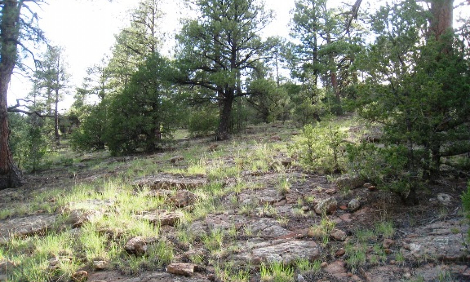
Figure 5. Sandstone hills 17-25" p.z. (PIPO)
This plant community is dominated by mature ponderosa pine with 20 to 35% canopy cover. Cover may be as high as 50% on north facing slopes with 10 - 20% cover of shorter ponderosa pine, Colorado pine, juniper and Gambel oak in the understory. Shrubs are small (
Figure 6. Annual production by plant type (representative values) or group (midpoint values)
Table 5. Annual production by plant type
Plant type Low
(lb/acre)Representative value
(lb/acre)High
(lb/acre)Grass/Grasslike 200 325 380 Tree 10 50 105 Forb 0 10 60 Shrub/Vine 0 5 40 Total 210 390 585 Table 6. Ground cover
Tree foliar cover 0-30% Shrub/vine/liana foliar cover 0-0% Grass/grasslike foliar cover 10-20% Forb foliar cover 0-10% Non-vascular plants 0-0% Biological crusts 0-10% Litter 20-50% Surface fragments >0.25" and <=3" 0-20% Surface fragments >3" 0-10% Bedrock 10-30% Water 0% Bare ground 0-10% Table 7. Canopy structure (% cover)
Height Above Ground (ft) Tree Shrub/Vine Grass/
GrasslikeForb <0.5 0-1% 0-5% 0-30% 1-5% >0.5 <= 1 0-1% 0-5% 0-5% 0-1% >1 <= 2 0-1% 0-1% 0-5% 0-1% >2 <= 4.5 0-5% 0-1% – – >4.5 <= 13 1-10% 0-1% – – >13 <= 40 1-10% – – – >40 <= 80 10-20% – – – >80 <= 120 1-10% – – – >120 – – – – Figure 7. Plant community growth curve (percent production by month). AZ3581 , 35.8 17-25" p.z. all sites. Growth begins in the spring, most growth occurs during the summer rainy season..
Jan Feb Mar Apr May Jun Jul Aug Sep Oct Nov Dec J F M A M J J A S O N D 0 0 0 4 10 24 21 23 13 5 0 0 Figure 8. Plant community growth curve (percent production by month). AZ3901 , 35.8 17-25" p.z. muttongrass. Growth begins in the spring and extends through the summer rainy season..
Jan Feb Mar Apr May Jun Jul Aug Sep Oct Nov Dec J F M A M J J A S O N D 0 0 0 5 10 30 20 20 10 5 0 0 Figure 9. Plant community growth curve (percent production by month). AZ3902 , 35.8 17-25" p.z. Arizona fescue. Growth begins in the late spring and extends through the summer rainy season..
Jan Feb Mar Apr May Jun Jul Aug Sep Oct Nov Dec J F M A M J J A S O N D 0 0 0 0 5 20 30 30 10 5 0 0 Figure 10. Plant community growth curve (percent production by month). AZ3903 , 35.8 17-25" p.z. western wheatgrass. Growth begins in the spring, most growth occurs in the summer. Seed set occurs in the fall..
Jan Feb Mar Apr May Jun Jul Aug Sep Oct Nov Dec J F M A M J J A S O N D 0 0 0 5 10 15 25 30 10 5 0 0 Community 1.2
Light Ponderosa Pine OverstoryThis site has a more patchy distribution of ponderosa pine with reduced canopy cover from the 1.1 community. This results in higher understory production on the forest floor of grasses, forbs and shrubs.
Community 1.3
Dense Ponderosa Pine OverstoryThis site has a very dense overstory of smaller pole sized and some mature ponderosa pine with canopy cover from 50-60%. The understory is sparse and shrub dominated.
Pathway 1.1a
Community 1.1 to 1.2Partial removal of mature ponderosa pine canopy through timber harvest, or Bark beetle infestation, fire.
Pathway 1.1b
Community 1.1 to 1.3Openings are filled in by natural regeneration, unmanaged grazing, fire exclusion.
Pathway 1.2a
Community 1.2 to 1.1Trees mature and fill in. Managed grazing, fire suppresion.
Pathway 1.2b
Community 1.2 to 1.3Openings are filled in by natural regeneration of Ponderosa pine from fire exclusion, unmanaged grazing.
Pathway 1.3a
Community 1.3 to 1.1Trees are thinnned either naturally or through commercial thinning.
Pathway 1.3b
Community 1.3 to 1.2Trees are thinnned through fire or timber harvest.
State 2
Reduced Overstory - GrasslandThis plant community is dominated by perennial grasses with forbs and shrubs and a few scattered trees.
Community 2.1
Reduced Overstory - GrasslandTree canopy has been severely reduced (
Transition T1A
State 1 to 2Catastrophic fire event leaves only a few scattered ponderosa pine.
Restoration pathway R1A
State 2 to 1Trees canopy increases - fire suppression, tree planting, unmanaged grazing.
Additional community tables
Table 8. Community 1.1 plant community composition
Group Common name Symbol Scientific name Annual production () Foliar cover (%) Grass/Grasslike1 Grasses 200–380 mountain muhly MUMO Muhlenbergia montana 25–100 – blue grama BOGR2 Bouteloua gracilis 25–75 – muttongrass POFE Poa fendleriana 5–50 – little bluestem SCSC Schizachyrium scoparium 5–50 – western wheatgrass PASM Pascopyrum smithii 0–25 – squirreltail ELEL5 Elymus elymoides 5–25 – Arizona fescue FEAR2 Festuca arizonica 0–25 – pine dropseed BLTR Blepharoneuron tricholepis 5–25 – sedge CAREX Carex 0–15 – Forb2 Forbs 0–60 Forb, perennial 2FP Forb, perennial 0–20 – spreading fleabane ERDI4 Erigeron divergens 0–15 – trailing fleabane ERFL Erigeron flagellaris 0–10 – Wright's deervetch LOWR Lotus wrightii 0–10 – ragleaf bahia BADI Bahia dissecta 0–10 – Shrub/Vine3 Shrubs 0–40 creeping barberry MARE11 Mahonia repens 0–15 – Fendler's ceanothus CEFE Ceanothus fendleri 0–15 – hairy false goldenaster HEVI4 Heterotheca villosa 0–10 – Stansbury cliffrose PUST Purshia stansburiana 0–10 – big sagebrush ARTR2 Artemisia tridentata 0–10 – wax currant RICE Ribes cereum 0–5 – mountain snowberry SYOR2 Symphoricarpos oreophilus 0–5 – Tree4 Trees 10–105 ponderosa pine PIPO Pinus ponderosa 10–50 – Gambel oak QUGA Quercus gambelii 0–25 – Utah juniper JUOS Juniperus osteosperma 0–10 – Rocky Mountain juniper JUSC2 Juniperus scopulorum 0–10 – twoneedle pinyon PIED Pinus edulis 0–10 – Table 9. Community 1.2 plant community composition
Group Common name Symbol Scientific name Annual production () Foliar cover (%) Table 10. Community 1.3 plant community composition
Group Common name Symbol Scientific name Annual production () Foliar cover (%) Table 11. Community 2.1 plant community composition
Group Common name Symbol Scientific name Annual production () Foliar cover (%) Interpretations
Animal community
Site is favorable for grazing throughout most of the year except when snow cover restricts availability of forage. Planned grazing systems adapt well to use on this site.
The potential plant community produced by this site provides food for those species of wildlife that utilize grass as a major portion of their diet.
Recreational uses
This site has a variety of spring and summer flowers which are particularly noticeable after good moisture periods. It has good aesthetic appeal when not severely disturbed.
Winters are cold, however, relatively mild spring, fall and summer months are attractive to recreationists. Recreational activities most likely to occur are hunting, cross-country riding, photography and wildlife observation.
Wood products
All kinds of equipment is suitable for harvesting, site preparation, tree planting and pre-commercial thinning. Slopes are non-restrictive. Un-surfaced roads limit equipment when wet. Water erosion is slight to moderate in bare areas; wind erosion is moderate to high.
Compaction potential is good, but soils will rut when wet. Re-vegetation potential is good.
Harvest fully grown trees on a sustained yield basis. Final removal cuts and intermediate cuts are desirable. Thick stands need thinned to improve growth rates of trees left. Periodic ground fires will reduce dense understory vegetation competing for moisture. Slopes are gentle and soils are deep, so mechanical tree removal is not limited. Control unwanted pests to limit tree damage and loss. Fire hazard becomes extreme as understory fuel load builds. Site is good for replanting. There is slight limitation to seedling mortality; expected mortality rate is less than 25%. Natural regeneration is slightly limited; low end of productive pine sites. Seedlings need protection from grazing. Plant competition is moderately limited due to dense grass cover and grazing that may impede regeneration. Wind throw hazard: slight limitation, rooting depth greater than 30".
Supporting information
Type locality
Location 1: McKinley County, NM UTM zone N UTM northing 3987350 UTM easting 687701 General legal description Todlito Park Quad, Defiance Plateau area, Navajo Reservation, South of Assayi Lake area. Other references
Updates and revisions for this ESD were conducted as part of a 2007-2012 Interagency Technical Assistance Agreement between the Bureau of Indian Affairs–Navajo Region and the NRCS-Arizona.
Contributors
Dean Schlichting
Ken Gishi
Larry D. EllicottApproval
Kendra Moseley, 5/20/2025
Rangeland health reference sheet
Interpreting Indicators of Rangeland Health is a qualitative assessment protocol used to determine ecosystem condition based on benchmark characteristics described in the Reference Sheet. A suite of 17 (or more) indicators are typically considered in an assessment. The ecological site(s) representative of an assessment location must be known prior to applying the protocol and must be verified based on soils and climate. Current plant community cannot be used to identify the ecological site.
Author(s)/participant(s) Contact for lead author Date 07/30/2026 Approved by Approval date Composition (Indicators 10 and 12) based on Annual Production Indicators
-
Number and extent of rills:
-
Presence of water flow patterns:
-
Number and height of erosional pedestals or terracettes:
-
Bare ground from Ecological Site Description or other studies (rock, litter, lichen, moss, plant canopy are not bare ground):
-
Number of gullies and erosion associated with gullies:
-
Extent of wind scoured, blowouts and/or depositional areas:
-
Amount of litter movement (describe size and distance expected to travel):
-
Soil surface (top few mm) resistance to erosion (stability values are averages - most sites will show a range of values):
-
Soil surface structure and SOM content (include type of structure and A-horizon color and thickness):
-
Effect of community phase composition (relative proportion of different functional groups) and spatial distribution on infiltration and runoff:
-
Presence and thickness of compaction layer (usually none; describe soil profile features which may be mistaken for compaction on this site):
-
Functional/Structural Groups (list in order of descending dominance by above-ground annual-production or live foliar cover using symbols: >>, >, = to indicate much greater than, greater than, and equal to):
Dominant:
Sub-dominant:
Other:
Additional:
-
Amount of plant mortality and decadence (include which functional groups are expected to show mortality or decadence):
-
Average percent litter cover (%) and depth ( in):
-
Expected annual annual-production (this is TOTAL above-ground annual-production, not just forage annual-production):
-
Potential invasive (including noxious) species (native and non-native). List species which BOTH characterize degraded states and have the potential to become a dominant or co-dominant species on the ecological site if their future establishment and growth is not actively controlled by management interventions. Species that become dominant for only one to several years (e.g., short-term response to drought or wildfire) are not invasive plants. Note that unlike other indicators, we are describing what is NOT expected in the reference state for the ecological site:
-
Perennial plant reproductive capability:
Print Options
Sections
Font
AAAAOther
PrintThe Ecosystem Dynamics Interpretive Tool is an information system framework developed by the USDA-ARS Jornada Experimental Range, USDA Natural Resources Conservation Service, and New Mexico State University.
Accessibility statement