Natural Resources
Conservation Service
Ecological site R034BY239UT
Semidesert Shallow Sandy Loam (Utah Juniper/Two-Needle Pinyon)
Last updated: 3/05/2022
Accessed: 06/26/2026
-
Search


Major Land Resource Area or ecological site by name and/or ID.
PreviousSectionsNextGeneral information
Provisional. A provisional ecological site description has undergone quality control and quality assurance review. It contains a working state and transition model and enough information to identify the ecological site.
MLRA notes
Major Land Resource Area (MLRA): 034B–Warm Central Desertic Basins and Plateaus
MLRA 34B occurs in is in Utah (70 percent) and Colorado (30 percent). It makes up about 12,850 square miles (33,290 square kilometers). A small part of the area is in the High Plateaus of Utah Section of the Colorado Plateaus Province of the Intermontane Plateaus. The northern part of the MLRA occurs in the Uinta Basin Section, which is bounded by the Uinta Mountains to the north, the Wasatch Range to the west, the Roan Plateau to the south, and the Rabbit Hills to the east. The southern part of the MLRA occurs in the northern third of the Canyon Lands Section. This section is bounded by the Roan Plateau to the north, the Wasatch Plateau to the west, the southern end of the San Rafael Swell to the south, and the western slope of the Rocky Mountains to the east. Elevation ranges from 4,100 feet (1,250 meters) near Green River, Utah, to 7,500 feet (2,285 meters) at the base of the Wasatch Range and the Roan Plateau.
Most of this area is covered by residual basin-floor materials and materials washed in from the surrounding mountains and plateaus. Shale and sandstone are the dominant rock types. The Tertiary-age Green River, Uinta, and Duchesne Formations dominate the northern part of the MLRA. The southern part is dominated by Cretaceous-age materials with lesser amounts of Jurassic and Triassic materials. The dominant Cretaceous formations are Mancos Shale, Dakota Sandstone, and the members of the Mesa Verde Group. The dominant Jurassic formations are the Morrison, Entrada, and Navajo. The dominant Triassic formations are the Chinle and Moenkopi. Quaternary alluvial, eolian, and glacial deposits occur in both parts of the MLRA.
The average annual precipitation in most of this area ranges from 6 to 10 inches (150 to 255 millimeters). A small part of this area receives as much as 24 inches of annual precipitation.
Much of the precipitation occurs as high-intensity, convective thunderstorms during the period July through September. May and June are usually the drier months. Precipitation is more evenly distributed throughout the year in the northern part of the MLRA than in the southern part, where there is a significant peak in late summer. The northern part of the MLRA receives more precipitation as snow during winter than the southern part. The average annual temperature ranges from 41 to 54 degrees F (5 to 12 degrees C). The freeze-free period averages 170 days and ranges from 110 to 235 days.
The dominant soil orders in this MLRA are Aridisols and Entisols. Mollisols occur at the higher elevations, particularly in the northern part of the MLRA. The dominant soil temperature regime is mesic, and the dominant soil moisture regime is aridic. The soils receiving less than 8 inches (205 millimeters) of precipitation annually have an aridic soil moisture regime. The soils receiving 8 to 12 inches (205 to 305 millimeters) have an aridic soil moisture regime that borders on ustic. The soils receiving 12 to 16 inches (305 to 405 millimeters) generally have an ustic soil moisture regime that borders on aridic. The dominant soil mineralogy is mixed and soils are formed in slope alluvium or residuum derived from shale or sandstone. Many of the soils are shallow or moderately deep to shale or sandstone bedrock. The soils at the lower elevations generally have significant amounts of calcium carbonate, salts, and gypsum.Ecological site concept
The soils of this site formed mostly in eolian deposits and/or slope alluvium over residuum weathered from sandstone. Surface soils are fine sandy loam, channery fine sandy loam, to gravelly fine sandy loam in texture. Rock fragments may be present on the soil surface and throughout the profile, but typically make up less than 35 percent of the soil volume. These soils are shallow, well-drained, and have moderate to moderately rapid permeability. pH is slightly to moderately alkaline.. Available water-holding capacity ranges from 1 to 3 inches of water in the upper 20 inches of soil. The soil moisture regime is mostly ustic aridic and the soil temperature regime is mesic. Precipitation ranges from 8-12 inches annually.
Associated sites
R034BY227UT Semidesert Shallow Loam (Black Sagebrush)
R034BY230UT Semidesert Shallow Loam (Salina Wildrye)
R034BY233UT Semidesert Shallow Loam (Utah Juniper-Pinyon)
Similar sites
R034BY233UT Semidesert Shallow Loam (Utah Juniper-Pinyon)
Table 1. Dominant plant species
Tree (1) Juniperus osteosperma
(2) Pinus edulisShrub (1) Artemisia nova
(2) Cercocarpus montanusHerbaceous (1) Achnatherum hymenoides
Physiographic features
Site is found on structural benches, outwash terraces, and erosion remnants. Slope gradients are typically 2 to 35 percent. Elevation of this site ranges from 5,200 to 7,000 feet.
Table 2. Representative physiographic features
Landforms (1) Structural bench
(2) Outwash terrace
(3) Erosion remnant
Runoff class Low to high Flooding frequency None Ponding frequency None Elevation 5200 – 7000 ft Slope 2 – 35 % Ponding depth 0 in Aspect Aspect is not a significant factor Climatic features
The climate of this site is dry subhumid and semiarid. It is characterized by cold, snowy winters and warm, dry summers. The average annual precipitation ranges from 8 to 12 inches. May and August thru October are typically the wettest months with June being the driest. The most reliable sources of moisture for plant growth are the snow that accumulates over the winter and spring rains. Summer thunderstorms are intermittent and sporadic in nature, and thus, are not reliable sources of moisture to support vegetative growth on this site. The mean annual air temperature ranges from 45 to 49 degrees.
Table 3 Representative climatic features
Frost-free period (characteristic range) Freeze-free period (characteristic range) Precipitation total (characteristic range) 10-10 in Frost-free period (average) 130 days Freeze-free period (average) 140 days Precipitation total (average) BarLineFigure 1. Monthly precipitation range
BarLineFigure 2. Monthly average minimum and maximum temperature
">Influencing water features
Trere are no water features influencing this site.
Soil features
The soils of this site formed mostly in eolian deposits and/or slope alluvium over residuum weathered from sandstone. Surface soils are fine sandy loam, channery fine sandy loam, to gravelly fine sandy loam in texture. Rock fragments may be present on the soil surface and throughout the profile, but typically make up less than 35 percent of the soil volume. These soils are shallow, well-drained, and have moderate to moderately rapid permeability. pH is slightly to moderately alkaline.. Available water-holding capacity ranges from 1 to 3 inches of water in the upper 20 inches of soil. The soil moisture regime is mostly ustic aridic and the soil temperature regime is mesic. Precipitation ranges from 8-12 inches annually.
This site has been used in the following soils surveys and has been correlated to the following components:
UT013—Duchesne: Hideout; Neola.
UT653-Uintah and Ouray Indian Reservation: Hideout; Neola.
Typical Soil Profile: (Hideout).
A—0-2 inches; fine sandy loam; disseminated calconates; slightly effervescent; moderately alkaline.
C1—2-10 inches;fine sandy loam; disseminated calconates; slightly effervescent; moderately alkaline.
R—10 inches; fractured sandstone bedrock.Table 4. Representative soil features
Parent material (1) Eolian sands – sandstone
(2) Slope alluvium – sandstone
(3) Residuum – sandstone
Surface texture (1) Fine sandy loam
(2) Channery fine sandy loam
(3) Gravelly fine sandy loam
Family particle size (1) Loamy
Drainage class Well drained Permeability class Moderately rapid Depth to restrictive layer 5 – 20 in Soil depth 5 – 20 in Surface fragment cover <=3" 2 – 25 % Surface fragment cover >3" 0 – 10 % Available water capacity
(0-20in)1 – 3 in Calcium carbonate equivalent
(0-20in)1 – 25 % Electrical conductivity
(0-20in)0 – 2 mmhos/cm Sodium adsorption ratio
(0-20in)Not specified Soil reaction (1:1 water)
(0-20in)7.4 – 8.4 Subsurface fragment volume <=3"
(0-20in)5 – 26 % Subsurface fragment volume >3"
(0-20in)0 – 4 % Ecological dynamics
This site developed under the Uintah Basin Section of the Southern Rocky Mountain Provence ecological conditions and the natural influences of herbivory, fire and climate. Species composition is generally dominated by an overstory canopy of Utah juniper and two-needle pinyon. Alderleaf mountain mahogany and black sagebrush are common shrub species. Perennial herbaceous species occurrence is directly related to canopy density with Indian ricegrass, James galleta and needle-and-thread found most often.
Evidence indicates that this site historically maintained a fairly long burn cycle (100 years or more). Very old Utah juniper and two-needle pinyon are common on most undisturbed sites. Over time, their canopies increase in density, reducing understory vegetation dramatically. Following stand removing fire, the understory vegetation flourishes, but over time is again reduced.
Severe drought and insect damage can affect two-needle pinyon in some locations, causing it die out, often allowing Utah juniper to increase. This event can also allow for an increase in shrubs and herbaceous species during periods when wetter years return.
As vegetative communities respond to changes caused by natural or manmade events that cause them to cross ecological thresholds, a return to previous states may not be possible. The amount of effort needed to affect desired vegetative shifts depends on a sites present biotic and abiotic features and the desired results.
The following State and Transition diagram depicts the most common plant communities found on this ecological site. It does not necessarily depict all the plant communities that can occur, but does show the most prevalent and repeatable. As more data are collected, some of these plant communities may be revised or removed, and new ones added. These descriptions capture the current knowledge and experience at the time of this revision.State and transition model
Custom diagramStandard diagram
More interactive model formats are also available. View Interactive Models
More interactive model formats are also available. View Interactive Models
Click on state and transition labels to scroll to the respective textState 3 submodel, plant communities
State 1
Reference StateThis state describes the biotic communities that may become established on this ecological site if all successional sequences are completed under natural disturbance conditions. The reference state is generally dominated by an overstory canopy of Utah juniper with lesser amounts of two-needle-pinyon. Alderleaf mountain mahogany and black sagebrush are the dominate shrubs. Indian ricegrass and James galleta are the most common grasses. Other native grasses, forbs, and shrubs may produce significant composition in the plant community.
The primary disturbance mechanisms are overstory canopy density, weather fluctuation, and fire. The reference state is self sustaining and resistant to change due to a high resistance to natural disturbances and a high resilience following those disturbances. When natural disturbances occur, the rate of recovery can be quite variable. Typically in the reference state, this ecological site will fluctuate between community phases 1.1 and 1.2.
Reference State: Plant communities influenced by canopy density, long term weather fluctuations, and periodic fire.
Indicators: A community dominated by Utah juniper, two-needle-pinyon, alderleaf mountain mahogany and black sagebrush. The density of the overstory canopy determines the amount and composition of the other native perennial grasses and forbs that may be present.
Feedbacks: Natural fluctuations in weather patterns that allow for a self sustaining Utah juniper, two-needle-pinyon, alderleaf mountain mahogany, black sagebrush and native grass community. Insect herbivory, more frequent fires, or other disturbances that may allow for the establishment of invasive species.
At-risk Community Phase: All communities are at risk when native plants are stressed and nutrients become available for invasive plants to establish.
Trigger: The establishment of invasive plant species.Community 1.1
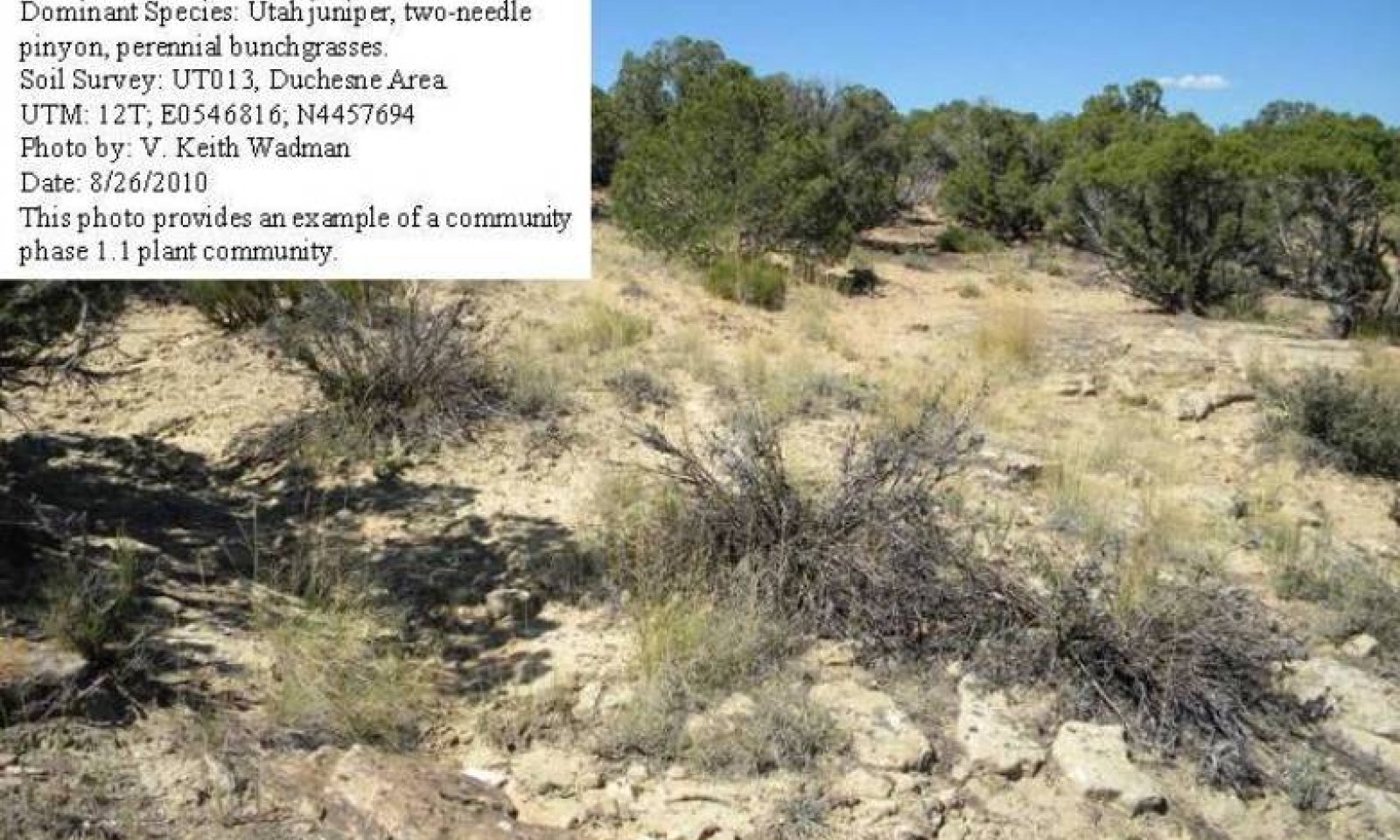
Open Canopy- Utah Juniper, Two-Needle Pinyon Herbaceous Understory Community Phase
Figure 3. Community Phase 1.1
This community phase is characterized by an open canopy of Utah juniper and two-needle pinyon. Alderleaf mountain mahogany and black sagebrush are the most common understory shrubs. Commonly occurring grasses and grasslikes include Indian ricegrass, James galleta and needle-and-thread. Other perennial grasses, shrubs, and forbs are also often present. Air dry composition of this site is approximately 10 percent forbs, 25 percent grasses, and 65 percent shrubs and trees. Bare ground is variable (35-55%) depending on biological crust cover, which is also variable (1-25%) and surface rock fragments (0-20%). Biological crusts can vary from sites dominated by light cyanobacteria in the plant interspaces, with occasional moss and lichen pinnacles under shrub canopies, to those dominated by lichen and moss pinnacles as well as cyanobacteria in the site interspaces.
The following tables provide an example the typical vegetative floristics of a community phase 1.1 plant community.Figure 4. Annual production by plant type (representative values) or group (midpoint values)
Table 5. Annual production by plant type
Plant type Low
(lb/acre)Representative value
(lb/acre)High
(lb/acre)Tree 80 125 160 Grass/Grasslike 80 100 130 Shrub/Vine 50 75 100 Forb 40 50 60 Total 250 350 450 Table 6. Ground cover
Tree foliar cover 20-30% Shrub/vine/liana foliar cover 20-30% Grass/grasslike foliar cover 20-20% Forb foliar cover 10-20% Non-vascular plants 0% Biological crusts 0% Litter 10-10% Surface fragments >0.25" and <=3" 0% Surface fragments >3" 0% Bedrock 0% Water 0% Bare ground 40-60% Community 1.2
Closed Canopy- Utah Juniper, Two-Needle Pinyon Community Phase.
Figure 5. Community Phase 1.2
This community phase is characterized by a closed canopy of Utah juniper and two-needle pinyon. Alderleaf mountain mahogany and black sagebrush are the most common understory shrubs. Commonly occurring grasses and grasslikes include Indian ricegrass, James galleta and needle-and-thread. Other perennial grasses, shrubs, and forbs are also often present. Air dry composition of this site is approximately 10 percent forbs, 15 percent grasses, and 75 percent shrubs and trees. Bare ground is variable (35-55%) depending on biological crust cover, which is also variable (1-25%) and surface rock fragments (0-20%). Biological crusts can vary from sites dominated by light cyanobacteria in the plant interspaces, with occasional moss and lichen pinnacles under shrub canopies, to those dominated by lichen and moss pinnacles as well as cyanobacteria in the site interspaces.
The following tables provide an example the typical vegetative floristics of a community phase 1.2 plant community.Figure 6. Annual production by plant type (representative values) or group (midpoint values)
Table 7. Annual production by plant type
Plant type Low
(lb/acre)Representative value
(lb/acre)High
(lb/acre)Tree 130 165 200 Shrub/Vine 50 75 100 Grass/Grasslike 30 60 90 Forb 40 50 60 Total 250 350 450 Table 8. Ground cover
Tree foliar cover 30-30% Shrub/vine/liana foliar cover 20-30% Grass/grasslike foliar cover 10-20% Forb foliar cover 10-20% Non-vascular plants 0% Biological crusts 0% Litter 10-10% Surface fragments >0.25" and <=3" 0% Surface fragments >3" 0% Bedrock 0% Water 0% Bare ground 40-60% Pathway 1.1A
Community 1.1 to 1.2
Open Canopy- Utah Juniper, Two-Needle Pinyon Herbaceous Understory Community Phase
Closed Canopy- Utah Juniper, Two-Needle Pinyon Community Phase.This community pathway occurs when long-term drought and/or extended periods without fire allows canopies of two-needle pinyon and Utah juniper to significantly increase. This closed canopy causes understory vegetation to be reduced or nearly eliminated from the site. Drought alone can also reduce native perennial grass production and eventually eliminate them from the system.
Pathway 1.2A
Community 1.2 to 1.1
Closed Canopy- Utah Juniper, Two-Needle Pinyon Community Phase.
Open Canopy- Utah Juniper, Two-Needle Pinyon Herbaceous Understory Community PhaseThis community pathway occurs when weather patterns return to within normal ranges and fire reduces two-needle pinyon and Utah juniper, significantly opening the sites canopy. Insect damage on two-needle pinyon can also cause it to be reduced on this site. This more open canopy allows understory vegetation to increase and under some circumstances, flourish on the site.
State 2
Current Potential StateThe current potential state is similar to the reference state, however invasive species are now present in all community phases. This state is generally dominated by Utah juniper with lesser amounts of two-needle pinyon present. Alderleaf mountain mahogany and black sagebrush are the most common shrubs. Depending on the sites disturbance history, native perennial grasses, forbs, or other shrubs may be common in the sites understory. Primary disturbance mechanisms are thought to include long-term weather fluctuations, insect herbivory, improper livestock grazing, fire interval and surface disturbances such as road and pipeline development and off road vehicle (OHV) use. Few disturbed sites have been located to date and so little data exists regarding them. The current potential state is still self sustaining but has less resistance to change due to lower resistance to disturbances and lower resilience following disturbances. This state will typically fluctuate between community phases 2.1 and 2.2.
Current Potential State: Plant communities influenced by livestock grazing, wildlife browsing, insect herbivory, weather fluctuations, fire periods and surface disturbances.
Indicators: A community dominated by Utah juniper, two-needle pinyon and black sagebrush where other shrubs and native perennial grasses and forbs may also be present. Invasive grasses and forbs are present.
Feedbacks: Natural fluctuations in weather that allow for a self sustaining Utah juniper, two-needle pinyon, black sagebrush and grass community.Community 2.1
Open Canopy- Utah Juniper, Two-Needle Pinyon Invasive Species Community Phase
Figure 7. Communith Phase 2.1
This community phase is characterized by an open canopy of Utah juniper and two-needle pinyon. Alderleaf mountain mahogany and black sagebrush are the most common understory shrubs. Commonly occurring grasses include cheatgrass, Indian ricegrass, James galleta and needle-and-thread. Other grasses, shrubs, and forbs are also often present. Air dry composition of this site is approximately 10 percent forbs, 25 percent grasses, and 65 percent shrubs and trees. Bare ground is variable (35-55%) depending on biological crust cover, which is also variable (1-25%) and surface rock fragments (0-20%). Biological crusts can vary from sites dominated by light cyanobacteria in the plant interspaces, with occasional moss and lichen pinnacles under shrub canopies, to those dominated by lichen and moss pinnacles as well as cyanobacteria in the site interspaces.
The following tables provide an example the typical vegetative floristics of a community phase 2.1 plant community.Figure 8. Annual production by plant type (representative values) or group (midpoint values)
Table 9. Annual production by plant type
Plant type Low
(lb/acre)Representative value
(lb/acre)High
(lb/acre)Tree 80 125 160 Grass/Grasslike 80 100 130 Shrub/Vine 50 75 100 Forb 40 50 60 Total 250 350 450 Table 10. Ground cover
Tree foliar cover 20-30% Shrub/vine/liana foliar cover 20-30% Grass/grasslike foliar cover 20-20% Forb foliar cover 10-20% Non-vascular plants 0% Biological crusts 0% Litter 10-10% Surface fragments >0.25" and <=3" 0% Surface fragments >3" 0% Bedrock 0% Water 0% Bare ground 40-60% Community 2.2
Closed Canopy- Utah Juniper, Two-Needle Pinyon Invasive Species Community Phase.
Figure 9. Community Phase 2.2
This community phase is characterized by a closed canopy of Utah juniper and two-needle pinyon. Alderleaf mountain mahogany and black sagebrush are the most common understory shrubs. Commonly occurring grasses and grasslikes include cheatgrass, Indian ricegrass, James galleta and needle-and-thread. Other grasses, shrubs, and forbs are also often present. Air dry composition of this site is approximately 5 percent forbs, 10 percent grasses, and 85 percent shrubs and trees. Bare ground is variable (35-55%) depending on biological crust cover, which is also variable (1-25%) and surface rock fragments (0-20%). Biological crusts can vary from sites dominated by light cyanobacteria in the plant interspaces, with occasional moss and lichen pinnacles under shrub canopies, to those dominated by lichen and moss pinnacles as well as cyanobacteria in the site interspaces.
The following tables provide an example the typical vegetative floristics of a community phase 2.2 plant community.Figure 10. Annual production by plant type (representative values) or group (midpoint values)
Table 11. Annual production by plant type
Plant type Low
(lb/acre)Representative value
(lb/acre)High
(lb/acre)Tree 130 165 200 Shrub/Vine 50 75 100 Grass/Grasslike 30 60 90 Forb 40 50 60 Total 250 350 450 Table 12. Ground cover
Tree foliar cover 30-30% Shrub/vine/liana foliar cover 20-30% Grass/grasslike foliar cover 10-20% Forb foliar cover 10-20% Non-vascular plants 0% Biological crusts 0% Litter 10-10% Surface fragments >0.25" and <=3" 0% Surface fragments >3" 0% Bedrock 0% Water 0% Bare ground 40-60% Pathway 2.1A
Community 2.1 to 2.2
Open Canopy- Utah Juniper, Two-Needle Pinyon Invasive Species Community Phase
Closed Canopy- Utah Juniper, Two-Needle Pinyon Invasive Species Community Phase.This community pathway occurs when long-term drought and/or extended periods without fire allows canopies of two-needle pinyon and Utah juniper to significantly increase. This closed canopy causes understory vegetation to be reduced or nearly eliminated from the site. Drought and/or improper livestock alone can also reduce native perennial grass production and eventually eliminate them from the system.
Pathway 2.2A
Community 2.2 to 2.1
Closed Canopy- Utah Juniper, Two-Needle Pinyon Invasive Species Community Phase.
Open Canopy- Utah Juniper, Two-Needle Pinyon Invasive Species Community PhaseThis community pathway occurs when weather patterns return to within normal ranges and fire reduces two-needle pinyon and Utah juniper, significantly opening the sites canopy. Insect damage on two-needle pinyon can also cause it to be reduced on this site. This more open canopy allows understory vegetation to increase and under some circumstances, flourish on the site.
State 3
Chained/Seeded StateThis state occurs when the site is chained to remove Utah juniper and two-needle pinyon trees. Following the chaining this area may or may not be burned and then seeded to native or introduced species such as Indian ricegrass or crested wheatgrass. Where sufficient understory species are present, the site might be allowed to recover naturally following the chaining.
Community 3.1
Chained and Seeded Community Phase.
Figure 11. Community Phase 3.1
This community phase is created when overstory canopies of Utah juniper and two-needle pinyon are chained or burned. This action releases understory species, allowing them to increase. Alder mountain mahogany and black sagebrush, where present, are the most likely to increase in the shrub layer. Other shrubs such as broom snakeweed and green rabbitbrush may also increase. Where herbaceous species do remain, cheatgrass, Indian ricegrass, James galleta and needle-and-thread are most likely to increase. Other annual and perennial grasses and forbs present may also increase following chaining. This site is often aerial seeded to either native or introduced species with Indian ricegrass and crested wheatgrass seeded most often. Air dry composition of this site following chaining is highly variable but a typical result is approximately 15 percent forbs, 35 percent grasses, and 50 percent shrubs. A few remaining trees are also normally present. Bare ground is variable (2-60%) depending on biological crust cover, which is also variable (1-25%) and surface rock fragments (0-20%). Biological crusts can vary from sites dominated by light cyanobacteria in the plant interspaces, with occasional moss and lichen pinnacles under shrub canopies, to those dominated by lichen and moss pinnacles as well as cyanobacteria in the site interspaces.
The following tables provide an example the typical vegetative floristics of a community phase 3.1 plant community.Figure 12. Annual production by plant type (representative values) or group (midpoint values)
Table 13. Annual production by plant type
Plant type Low
(lb/acre)Representative value
(lb/acre)High
(lb/acre)Grass/Grasslike 100 140 180 Shrub/Vine 50 75 100 Tree 20 50 80 Forb 40 50 60 Total 210 315 420 Table 14. Ground cover
Tree foliar cover 0-10% Shrub/vine/liana foliar cover 20-30% Grass/grasslike foliar cover 20-30% Forb foliar cover 10-20% Non-vascular plants 0% Biological crusts 0% Litter 10-10% Surface fragments >0.25" and <=3" 0% Surface fragments >3" 0% Bedrock 0% Water 0% Bare ground 30-50% Transition T1A
State 1 to 2This transitional pathway occurs when improper livestock grazing causes the perennial herbaceous community to become significantly reduced allowing non-native species such as cheatgrass, russian thistle and other invasive weeds to become established. Broom snakeweed may also increase during this time. Once invasive species occupy the site, a threshold has been crossed. Cheatgrass has been known to become established in healthy communities on this site, however.
Transition T2A
State 2 to 3This transitional pathway occurs when the site is chained and seeded to introduced species including creasted wheatgrass and intermediate wheatgrass. During seeding establishment non-native species such as cheatgrass, russian thistle and ragweed species may also become established. Broom snakeweed may increase during this time. Once introduced and invasive species occupy the site, a threshold has been crossed.
Additional community tables
Table 15. Community 1.1 plant community composition
Group Common name Symbol Scientific name Annual production () Foliar cover (%) Grass/Grasslike1 Dominant Grasses 75–125 James' galleta PLJA Pleuraphis jamesii 30–60 – Indian ricegrass ACHY Achnatherum hymenoides 30–60 – needle and thread HECO26 Hesperostipa comata 20–40 – 2 Sub-Dominant Grasses 30–60 blue grama BOGR2 Bouteloua gracilis 10–20 – Geyer's sedge CAGE2 Carex geyeri 10–20 – squirreltail ELEL5 Elymus elymoides 10–20 – saline wildrye LESA4 Leymus salinus 10–20 – Sandberg bluegrass POSE Poa secunda 10–20 – bluebunch wheatgrass PSSP6 Pseudoroegneria spicata 10–20 – Forb3 Forbs 60–90 low pussytoes ANDI2 Antennaria dimorpha 10–20 – Holboell's rockcress ARHO2 Arabis holboellii 10–20 – woollypod milkvetch ASPU9 Astragalus purshii 10–20 – aridland goosefoot CHDE Chenopodium desiccatum 10–20 – narrowstem cryptantha CRGR3 Cryptantha gracilis 10–20 – roundspike cryptantha CRHU2 Cryptantha humilis 10–20 – sulphur-flower buckwheat ERUM Eriogonum umbellatum 10–20 – scarlet gilia IPAG Ipomopsis aggregata 10–20 – hoary tansyaster MACA2 Machaeranthera canescens 10–20 – rock goldenrod PEPU7 Petradoria pumila 10–20 – Whipple's penstemon PEWH Penstemon whippleanus 10–20 – spiny phlox PHHO Phlox hoodii 10–20 – longleaf phlox PHLO2 Phlox longifolia 10–20 – basindaisy PLIN7 Platyschkuhria integrifolia 10–20 – woolly plantain PLPA2 Plantago patagonica 10–20 – stemless mock goldenweed STAC Stenotus acaulis 10–20 – longstalk clover TRLO Trifolium longipes 10–20 – American vetch VIAM Vicia americana 10–20 – Shrub/Vine4 Dominant Shrubs 80–120 alderleaf mountain mahogany CEMO2 Cercocarpus montanus 50–80 – black sagebrush ARNO4 Artemisia nova 30–60 – 5 Sub-Dominant Shrubs 40–80 antelope bitterbrush PUTR2 Purshia tridentata 20–30 – blue elderberry SANIC5 Sambucus nigra ssp. cerulea 10–20 – narrowleaf yucca YUAN2 Yucca angustissima 10–20 – yellow rabbitbrush CHVI8 Chrysothamnus viscidiflorus 10–20 – mormon tea EPVI Ephedra viridis 10–20 – slender buckwheat ERMI4 Eriogonum microthecum 10–20 – spiny hopsage GRSP Grayia spinosa 10–20 – broom snakeweed GUSA2 Gutierrezia sarothrae 10–20 – Mexican cliffrose PUME Purshia mexicana 10–20 – Tree6 Dominant Trees 80–120 Utah juniper JUOS Juniperus osteosperma 80–125 – twoneedle pinyon PIED Pinus edulis 30–50 – Table 16. Community 1.2 plant community composition
Group Common name Symbol Scientific name Annual production () Foliar cover (%) Grass/Grasslike1 Dominant Grasses 50–75 James' galleta PLJA Pleuraphis jamesii 20–40 – Indian ricegrass ACHY Achnatherum hymenoides 20–40 – needle and thread HECO26 Hesperostipa comata 15–30 – 2 Sub-Dominant Grasses 30–60 blue grama BOGR2 Bouteloua gracilis 10–20 – Geyer's sedge CAGE2 Carex geyeri 10–20 – squirreltail ELEL5 Elymus elymoides 10–20 – saline wildrye LESA4 Leymus salinus 10–20 – Sandberg bluegrass POSE Poa secunda 10–20 – bluebunch wheatgrass PSSP6 Pseudoroegneria spicata 10–20 – Forb3 Forbs 60–90 low pussytoes ANDI2 Antennaria dimorpha 10–20 – Holboell's rockcress ARHO2 Arabis holboellii 10–20 – woollypod milkvetch ASPU9 Astragalus purshii 10–20 – aridland goosefoot CHDE Chenopodium desiccatum 10–20 – narrowstem cryptantha CRGR3 Cryptantha gracilis 10–20 – roundspike cryptantha CRHU2 Cryptantha humilis 10–20 – sulphur-flower buckwheat ERUM Eriogonum umbellatum 10–20 – scarlet gilia IPAG Ipomopsis aggregata 10–20 – hoary tansyaster MACA2 Machaeranthera canescens 10–20 – rock goldenrod PEPU7 Petradoria pumila 10–20 – Whipple's penstemon PEWH Penstemon whippleanus 10–20 – spiny phlox PHHO Phlox hoodii 10–20 – longleaf phlox PHLO2 Phlox longifolia 10–20 – basindaisy PLIN7 Platyschkuhria integrifolia 10–20 – woolly plantain PLPA2 Plantago patagonica 10–20 – stemless mock goldenweed STAC Stenotus acaulis 10–20 – longstalk clover TRLO Trifolium longipes 10–20 – American vetch VIAM Vicia americana 10–20 – Shrub/Vine4 Dominant Shrubs 80–120 alderleaf mountain mahogany CEMO2 Cercocarpus montanus 50–80 – black sagebrush ARNO4 Artemisia nova 30–60 – 5 Sub-Dominant Shrubs 40–80 antelope bitterbrush PUTR2 Purshia tridentata 20–30 – blue elderberry SANIC5 Sambucus nigra ssp. cerulea 10–20 – narrowleaf yucca YUAN2 Yucca angustissima 10–20 – yellow rabbitbrush CHVI8 Chrysothamnus viscidiflorus 10–20 – mormon tea EPVI Ephedra viridis 10–20 – slender buckwheat ERMI4 Eriogonum microthecum 10–20 – spiny hopsage GRSP Grayia spinosa 10–20 – broom snakeweed GUSA2 Gutierrezia sarothrae 10–20 – Mexican cliffrose PUME Purshia mexicana 10–20 – Tree6 Dominant Trees 120–200 Utah juniper JUOS Juniperus osteosperma 100–175 – twoneedle pinyon PIED Pinus edulis 50–75 – Table 17. Community 2.1 plant community composition
Group Common name Symbol Scientific name Annual production () Foliar cover (%) Grass/Grasslike1 Dominant Grasses 75–125 Indian ricegrass ACHY Achnatherum hymenoides 30–60 – James' galleta PLJA Pleuraphis jamesii 30–60 – needle and thread HECO26 Hesperostipa comata 20–40 – 2 Sub-Dominant Grasses 30–60 cheatgrass BRTE Bromus tectorum 20–40 – Geyer's sedge CAGE2 Carex geyeri 10–20 – squirreltail ELEL5 Elymus elymoides 10–20 – saline wildrye LESA4 Leymus salinus 10–20 – Sandberg bluegrass POSE Poa secunda 10–20 – bluebunch wheatgrass PSSP6 Pseudoroegneria spicata 10–20 – blue grama BOGR2 Bouteloua gracilis 10–20 – Forb3 Forbs 60–90 desert madwort ALDE Alyssum desertorum 10–20 – annual ragweed AMAR2 Ambrosia artemisiifolia 10–20 – low pussytoes ANDI2 Antennaria dimorpha 10–20 – Holboell's rockcress ARHO2 Arabis holboellii 10–20 – woollypod milkvetch ASPU9 Astragalus purshii 10–20 – aridland goosefoot CHDE Chenopodium desiccatum 10–20 – narrowstem cryptantha CRGR3 Cryptantha gracilis 10–20 – roundspike cryptantha CRHU2 Cryptantha humilis 10–20 – sulphur-flower buckwheat ERUM Eriogonum umbellatum 10–20 – scarlet gilia IPAG Ipomopsis aggregata 10–20 – hoary tansyaster MACA2 Machaeranthera canescens 10–20 – rock goldenrod PEPU7 Petradoria pumila 10–20 – Whipple's penstemon PEWH Penstemon whippleanus 10–20 – spiny phlox PHHO Phlox hoodii 10–20 – longleaf phlox PHLO2 Phlox longifolia 10–20 – basindaisy PLIN7 Platyschkuhria integrifolia 10–20 – woolly plantain PLPA2 Plantago patagonica 10–20 – Russian thistle SAKA Salsola kali 10–20 – stemless mock goldenweed STAC Stenotus acaulis 10–20 – longstalk clover TRLO Trifolium longipes 10–20 – American vetch VIAM Vicia americana 10–20 – Shrub/Vine4 Dominant Shrubs 80–120 alderleaf mountain mahogany CEMO2 Cercocarpus montanus 50–80 – black sagebrush ARNO4 Artemisia nova 30–60 – 5 Sub-Dominant Shrubs 40–80 antelope bitterbrush PUTR2 Purshia tridentata 20–30 – blue elderberry SANIC5 Sambucus nigra ssp. cerulea 10–20 – narrowleaf yucca YUAN2 Yucca angustissima 10–20 – yellow rabbitbrush CHVI8 Chrysothamnus viscidiflorus 10–20 – mormon tea EPVI Ephedra viridis 10–20 – slender buckwheat ERMI4 Eriogonum microthecum 10–20 – spiny hopsage GRSP Grayia spinosa 10–20 – broom snakeweed GUSA2 Gutierrezia sarothrae 10–20 – Mexican cliffrose PUME Purshia mexicana 10–20 – Tree6 Dominant Trees 80–120 Utah juniper JUOS Juniperus osteosperma 80–125 – twoneedle pinyon PIED Pinus edulis 30–50 – Table 18. Community 2.2 plant community composition
Group Common name Symbol Scientific name Annual production () Foliar cover (%) Grass/Grasslike1 Dominant Grasses 50–75 James' galleta PLJA Pleuraphis jamesii 20–40 – Indian ricegrass ACHY Achnatherum hymenoides 20–40 – cheatgrass BRTE Bromus tectorum 20–40 – needle and thread HECO26 Hesperostipa comata 15–30 – 2 Sub-Dominant Grasses 30–60 blue grama BOGR2 Bouteloua gracilis 10–20 – Geyer's sedge CAGE2 Carex geyeri 10–20 – squirreltail ELEL5 Elymus elymoides 10–20 – saline wildrye LESA4 Leymus salinus 10–20 – Sandberg bluegrass POSE Poa secunda 10–20 – bluebunch wheatgrass PSSP6 Pseudoroegneria spicata 10–20 – Forb3 Forbs 60–90 desert madwort ALDE Alyssum desertorum 10–20 – annual ragweed AMAR2 Ambrosia artemisiifolia 10–20 – low pussytoes ANDI2 Antennaria dimorpha 10–20 – Holboell's rockcress ARHO2 Arabis holboellii 10–20 – woollypod milkvetch ASPU9 Astragalus purshii 10–20 – aridland goosefoot CHDE Chenopodium desiccatum 10–20 – narrowstem cryptantha CRGR3 Cryptantha gracilis 10–20 – roundspike cryptantha CRHU2 Cryptantha humilis 10–20 – sulphur-flower buckwheat ERUM Eriogonum umbellatum 10–20 – scarlet gilia IPAG Ipomopsis aggregata 10–20 – hoary tansyaster MACA2 Machaeranthera canescens 10–20 – rock goldenrod PEPU7 Petradoria pumila 10–20 – Whipple's penstemon PEWH Penstemon whippleanus 10–20 – spiny phlox PHHO Phlox hoodii 10–20 – longleaf phlox PHLO2 Phlox longifolia 10–20 – basindaisy PLIN7 Platyschkuhria integrifolia 10–20 – woolly plantain PLPA2 Plantago patagonica 10–20 – Russian thistle SAKA Salsola kali 10–20 – stemless mock goldenweed STAC Stenotus acaulis 10–20 – longstalk clover TRLO Trifolium longipes 10–20 – American vetch VIAM Vicia americana 10–20 – Shrub/Vine4 Dominant Shrubs 80–120 alderleaf mountain mahogany CEMO2 Cercocarpus montanus 50–80 – black sagebrush ARNO4 Artemisia nova 30–60 – 5 Sub-Dominant Shrubs 40–80 antelope bitterbrush PUTR2 Purshia tridentata 20–30 – blue elderberry SANIC5 Sambucus nigra ssp. cerulea 10–20 – narrowleaf yucca YUAN2 Yucca angustissima 10–20 – yellow rabbitbrush CHVI8 Chrysothamnus viscidiflorus 10–20 – mormon tea EPVI Ephedra viridis 10–20 – slender buckwheat ERMI4 Eriogonum microthecum 10–20 – spiny hopsage GRSP Grayia spinosa 10–20 – broom snakeweed GUSA2 Gutierrezia sarothrae 10–20 – Mexican cliffrose PUME Purshia mexicana 10–20 – Tree6 Dominant Trees 120–200 Utah juniper JUOS Juniperus osteosperma 100–175 – twoneedle pinyon PIED Pinus edulis 50–75 – Table 19. Community 3.1 plant community composition
Group Common name Symbol Scientific name Annual production () Foliar cover (%) Grass/Grasslike1 Dominant Grasses 200–250 Indian ricegrass ACHY Achnatherum hymenoides 50–200 – crested wheatgrass AGCR Agropyron cristatum 0–150 – James' galleta PLJA Pleuraphis jamesii 30–60 – needle and thread HECO26 Hesperostipa comata 20–40 – 2 Sub-Dominant Grasses 30–60 cheatgrass BRTE Bromus tectorum 40–80 – Geyer's sedge CAGE2 Carex geyeri 10–20 – squirreltail ELEL5 Elymus elymoides 10–20 – saline wildrye LESA4 Leymus salinus 10–20 – Sandberg bluegrass POSE Poa secunda 10–20 – bluebunch wheatgrass PSSP6 Pseudoroegneria spicata 10–20 – blue grama BOGR2 Bouteloua gracilis 10–20 – Forb3 Forbs 60–90 desert madwort ALDE Alyssum desertorum 10–20 – low pussytoes ANDI2 Antennaria dimorpha 10–20 – Holboell's rockcress ARHO2 Arabis holboellii 10–20 – woollypod milkvetch ASPU9 Astragalus purshii 10–20 – aridland goosefoot CHDE Chenopodium desiccatum 10–20 – narrowstem cryptantha CRGR3 Cryptantha gracilis 10–20 – roundspike cryptantha CRHU2 Cryptantha humilis 10–20 – sulphur-flower buckwheat ERUM Eriogonum umbellatum 10–20 – scarlet gilia IPAG Ipomopsis aggregata 10–20 – hoary tansyaster MACA2 Machaeranthera canescens 10–20 – rock goldenrod PEPU7 Petradoria pumila 10–20 – Whipple's penstemon PEWH Penstemon whippleanus 10–20 – spiny phlox PHHO Phlox hoodii 10–20 – longleaf phlox PHLO2 Phlox longifolia 10–20 – basindaisy PLIN7 Platyschkuhria integrifolia 10–20 – woolly plantain PLPA2 Plantago patagonica 10–20 – Russian thistle SAKA Salsola kali 10–20 – stemless mock goldenweed STAC Stenotus acaulis 10–20 – longstalk clover TRLO Trifolium longipes 10–20 – American vetch VIAM Vicia americana 10–20 – Shrub/Vine4 Dominant Shrubs 80–120 alderleaf mountain mahogany CEMO2 Cercocarpus montanus 50–80 – black sagebrush ARNO4 Artemisia nova 30–60 – 5 Sub-Dominant Shrubs 40–80 antelope bitterbrush PUTR2 Purshia tridentata 20–30 – blue elderberry SANIC5 Sambucus nigra ssp. cerulea 10–20 – narrowleaf yucca YUAN2 Yucca angustissima 10–20 – yellow rabbitbrush CHVI8 Chrysothamnus viscidiflorus 10–20 – mormon tea EPVI Ephedra viridis 10–20 – slender buckwheat ERMI4 Eriogonum microthecum 10–20 – spiny hopsage GRSP Grayia spinosa 10–20 – broom snakeweed GUSA2 Gutierrezia sarothrae 10–20 – Mexican cliffrose PUME Purshia mexicana 10–20 – Tree6 Dominant Trees 20–60 Utah juniper JUOS Juniperus osteosperma 15–30 – twoneedle pinyon PIED Pinus edulis 15–25 – Interpretations
Animal community
--Wildlife Interpretation--
Small herds of mule deer, pronghorn antelope, and elk can be seen grazing/browsing on these sites, especially when near water sources and in the winter. The hot summers and lack of water favors small mammals, which have an easier time finding shelter, food, and water. Many species of rats, mice, squirrels, bats, and chipmunks can be observed, along with coyotes and foxes. Utah juniper provides good habitat for several bird species including juniper titmice, scrub jays, pinyon jays, and black throated gray warblers, and sparrows. Lizards are the most visible and can be observed during the day. (NPS.gov, 2008).
--Grazing Interpretations--
The open canopy community phases of this site can provide fair spring, fall, and winter grazing conditions for livestock because of its accessible but somewhat limited nutritious forage. This site may lack natural perennial water sources, however, which can influence its suitability for livestock grazing. The plant community is primarily composed of an overstory canopy of Utah juniper and two-needle pinyon with an understory of perennial grasses, with Indian ricegrass, James galleta, and needle-and-thread occurring most often. Shrubs, including black sagebrush and alderleaf mountain mahogany can provide some winter browse for cattle, sheep, and goats. Forb composition and annual production depends primarily on precipitation amounts, and thus, is challenging to use in making livestock grazing management decisions. However, forb composition should be monitored for species diversity, as well as the occurence of poisonous or injurious plant communities which may be detrimental to livestock if grazed. Before making specific grazing management recommendations, a science based grazing management plan should be developed.Hydrological functions
The soils associated with this ecological site are generally in Hydrologic Soil Group D.
Soils in this group have high runoff potential when thoroughly wet. Water movement through the soil is restricted or very restricted. All soils with a depth to a water impermeable layer less than 50 centimeters [20 inches]. In this case the shallow soil over bedrock puts this ESD in group D. The runoff curve numbers are 80 to 89 depending on the overall watershed condition. Hydrological groups are used in equations that estimate runoff from rainfall. These estimates are needed for solving hydrologic problems that arise in planning watershed-protection and flood-prevention projects and for designing structures for the use, control and disposal of water. (NRCS National Engineering Handbook). In areas similar to the reference state where ground cover is adequate, infiltration is increased and runoff potential is decreased. In areas where ground cover is less, infiltration is reduced and runoff potential is increased.Recreational uses
Recreation activities include aesthetic value and fair opportunities for hiking and hunting. Trees can provide some screening values for camping and picnicking. In good condition there are several forbs and shrubs that bloom in the spring. Shallow soils limit this site’s ability to be used for vacation homes, other residences, or deep ponds.
Wood products
Two-needle pinyon and Utah juniper can provide firewood and fence post where growth is sufficient and regulations allow for such use.
Other information
--Poisonous and Toxic Plant Communities--
Toxic plants associated with this site include woolly locoweed, broom snakeweed, and Russian thistle.
Woolly locoweed is toxic to all classes of livestock and wildlife. Locoweed is palatable and has similar nutrient value to alfalfa, which may cause animals to consume it even when other forage is available. Locoweed contains swainsonine (indolizdine alkaloid) and is poisonous at all stages of growth. Poisoning will become evident after 2-3 weeks of continuous grazing and is associated with 4 major symptoms: 1) neurological damage, 2) emaciation, 3) reproductive failure and abortion, and 4) congestive heart failure linked with “high mountain disease”.
Broom snakeweed contains steroids, terpenoids, saponins, and flavones that can cause abortions or reproductive failure in sheep and cattle, however, cattle are most susceptible. These toxins are most abundant during active growth and leafing stage. Cattle and sheep generally will only graze broom snakeweed when other forage is unavailable, typically in winter when toxicity levels are at their lowest (Knight and Walter, 2001).
Russian thistle is an invasive toxic plant, causing nitrate and to a lesser extent oxalate poisoning, which affects all classes of livestock. The buildup of nitrates in these plants is highly dependent upon environmental factors such as after a rain storm, during a drought, during periods with cool/cloudy days, and when growing on soils high in nitrogen and low in sulfur and phosphorus. Nitrate collects in the stems and can persist throughout the growing season. Clinical signs of nitrate poisoning include drowsiness, weakness, muscular tremors, increased heart and respiratory rates, staggering gait, and death. Conversely, oxalate poisoning causes kidney failure; clinical signs include muscle tremors, tetany, weakness, and depression. Poisoning generally occurs when livestock consume and are not accustomed to grazing oxalate-containing plants. Animals with prior exposure to oxalates have increased numbers of oxalate-degrading rumen microflora, and thus, are able to degrade the toxin before clinical poisoning can occur.
--Invasive Plant Communities--
Generally, as ecological conditions deteriorate and perennial vegetation decreases due to disturbance (fire, drought, off road vehicle overuse, erosion, etc.) annual forbs and grasses may invade the site. Of particular concern in semi-arid environments are annual invaders including cheatgrass, Russian thistle, alyssum and annual mustards. The presence of these species will depend on soil properties and moisture availability; however, these invaders are highly adaptive and can flourish in many locations. Once established, complete removal is difficult, but suppression may be possible.
On well developed Utah juniper and two-needle pinyon communities, soils are often completely occupied by lateral roots which can inhibit the herbaceous understory as well as limit annual invasive species. Once these sites are disturbed and pinyon-juniper communities begin to decline, their increase or invasion is possible.
--Fire Ecology--
The ability for an ecological site to carry fire depends primarily on its' present fuel load and plant moisture content. Sites with small fuel loads will burn more slowly and less intensely than sites with large fuel loads. The two-needle pinyon and Utah juniper communities growing on shallow soils are quite unique. These trees can support stand-replacing fires, though historically, fires were likely a mixture of surface and crown fires with intensities and frequencies dependent on site productivity. Most research agrees that historic fire return intervals are at a minimum 100 years, indicating that fire may have not played an important role in short term community dynamics. Fires are more common when trees are stressed or dead due to drought and/or beetle infestations. Pinyon-juniper stands reestablish either by seeds dispersed from adjacent unburned patches or by unburned seeds found at the burn site. Continuous (every 20-40 years) burning of these ecological sites can result in shrub dominated communities, due to the relatively fast recovery of shrubs when compared to trees. If invasive annual grasses are allowed to establish, fires may become more frequent, inhibiting the site’s ability to recover.Supporting information
Other references
Baily, R.G. 1995. Description of the ecoregions of the United Sates. Available http://www.fs.fed.us/land/ecosysmgmt/ecoreg1_home.html. Accessed February 27, 2008.
Belnap, J. and S.L. Phillips. 2001. Soil biota in an ungrazed grassland: response to annual grass (Bromus tectorum) invasion. Ecological Applications. 11:1261-1275
Chapin, S.F., B.H. Walker, R.J. Hobbs, D.U. Hooper, J.H. Lawton, O.E. Sala, and D. Tilman. 1997. Biotic control over the functioning of ecosystems. Science. 277:500-504
Cox R.D. and V.J. Anderson. 2004. Increasing native diversity of cheatgrass-dominated rangeland through assisted succession. Journal of Range Management. 57:203-210,
Howard, Janet L. 2003. Atriplex canescens. In: Fire Effects Information System. U.S. Department of Agriculture, Forest Service, Rocky Mountain Research Station, Fire Sciences Laboratory (Producer). Available: http://www.fs.fed.us/database/feis/. Accessed on February 25, 2008.
Knight, A.P. and R.G. Walter. 2001. A guide to plant poisoning of animals in North America. Teton NewMedia. Jackson, WY.
National Engineering Handbook. US Department of Agriculture, Natural Resources Conservation Service. Available: http://www.info.usda.gov/CED/Default.cfm#National%20Engineering%20Handbook. Accessed February 25, 2008.
NRCS Grazing Lands Technology Institute. 2003. National Range and Pasture Handbook. Fort Worth, TX, USA: US Department of Agriculture, Natural Resources Conservation Service, 190-VI-NRPH.
Tilley, D.J. 2007. Reintroducing native plants to the American West. Aberdeen Plant Materials Center, Aberdeen, ID, USA: US Department of Agriculture. Available: http://plant-materials.nrcs.usda.gov/idpmc/publications.html. Accessed February 22, 2008.
Utah Climate Summaries. 2008. Available: http://www.wrcc.dri.edu/summary/climsmut.html. Accessed on February 25, 2008.
Utah Division of Wildlife Resources. 2007.
Woods, A.J., D.A. Lammers, S.A. Bryce, J.M. Omernik, R.L. Denton, M. Domeier, and J.A. Comstock. 2001. Ecoregions of Utah (color poster with map, descriptive text, summary tables, and photographs). Reston, Virginia, U.S. Geological Survey (map scale 1:1,175,000).
Contributors
V. Keith Wadman
Approval
Kirt Walstad, 3/05/2022
Rangeland health reference sheet
Interpreting Indicators of Rangeland Health is a qualitative assessment protocol used to determine ecosystem condition based on benchmark characteristics described in the Reference Sheet. A suite of 17 (or more) indicators are typically considered in an assessment. The ecological site(s) representative of an assessment location must be known prior to applying the protocol and must be verified based on soils and climate. Current plant community cannot be used to identify the ecological site.
Author(s)/participant(s) Robert Stager (BLM), Randy Beckstrand (BLM), V. Keith Wadman (NRCS Ret.), Dana Truman (NRCS), Paul Curtis (BLM), Shane A. Green (NRCS). Contributors to 2/2008 revisions included Shane Green and Dana Truman (NRCS), Kim Allison, Ann Marie Aubrey, Lynn Jackson, Pam Riddle, Daryl Trotter and David Williams (BLM), Mike Duniway and Jeff Herrick (ARS). Modified for this site by V. Keith Wadman. Contact for lead author shane.green@ut.usda.gov Date 02/08/2008 Approved by Approval date Composition (Indicators 10 and 12) based on Annual Production Indicators
-
Number and extent of rills:
Rills may form immediately following large storm events but should not persist more than one or two winters. There should be very few on slopes <6%. On slopes >6%, rills may be 5-10 feet in length. Rills are most likely to form below adjacent exposed bedrock or water flow patterns where sufficient water accumulates to cause erosion. -
Presence of water flow patterns:
None to few. If present, they should be short (3-6’) on slopes <6%, increasing in frequency and length (up to 5-10’) with slope. waterflow patterns located below exposed bedrock should be narrow (<1-1½’) but may be long. They should be widely spaced (15-20 yrds) on slopes <6%, increasing in frequency (every 10-15yrds) with slope. Waterflow patterns should dissipate where the slope flattens. -
Number and height of erosional pedestals or terracettes:
Occasional terracettes may be associated with accumulation behind woody Utah juniper litter. Well developed biological crusts may appear pedestalled, but are actually a characteristic of the crust formation. -
Bare ground from Ecological Site Description or other studies (rock, litter, lichen, moss, plant canopy are not bare ground):
35-55%, in non-bedrock areas. Some bare ground is associated with water flow patterns. Areas with well developed biological soil crusts should not be counted as bare ground. Areas with poorly developed biological soil crusts that are interpreted as functioning as bare ground (therefore they would be susceptible to raindrop splash erosion) should be recorded as bare ground. Ground cover is based on first raindrop impact. Bare ground is the opposite of ground cover. Ground cover + bare ground = 100%. -
Number of gullies and erosion associated with gullies:
No active gullies. Some stable gullies may be present in landscape settings where increased runoff may accumulate (such as areas below exposed bedrock). Such gully development is expected to be limited to slopes exceeding 15%. Any gullies present should show little sign of accelerated erosion and should be stabilized with perennial vegetation and biological soil crusts. -
Extent of wind scoured, blowouts and/or depositional areas:
There should be very little evidence of active wind scoured, blowout or depositional areas. Wind caused deposition found at the base of shrubs and trees should be stabilized by biological soil crusts or litter. -
Amount of litter movement (describe size and distance expected to travel):
There may be movement of fine litter outside of the stable waterflow patterns of up to 2-4’on slopes <6% and 5-10’ on steeper slopes . Fine litter may be redistributed in the stable waterflow patterns following large storm events, depositing where the slope flattens or behind obstructions. Woody litter should not move from beneath the plant. -
Soil surface (top few mm) resistance to erosion (stability values are averages - most sites will show a range of values):
This site should have a soil stability rating of 4-5 throughout the site. Surface texture varies from fine sandy loams to channery sandy loams. -
Soil surface structure and SOM content (include type of structure and A-horizon color and thickness):
Soil surface (A horizon) is 0 to 2 inches deep. Structure is weak fine blocky parting to single grain. Color is brown (7.5YR5/4 or 4/4). The A horizon would be expected to be more strongly developed under plant canopies. It is important, if you are sampling, to observe the A horizon under plant canopies as well as the interspaces. Use the specific information for the soil you are assessing found in the published soil survey to supplement this description. -
Effect of community phase composition (relative proportion of different functional groups) and spatial distribution on infiltration and runoff:
Distribution of vascular plants and/or biological soil crusts (where present) intercept raindrops preventing, but not eliminating, reduction of infiltration due to physical crusting. Plants and/or biological soil crusts usually have sufficient cover to slow runoff allowing time for infiltration. Shrubs, trees, and perennial grasses and associated plant litter provide barriers to flow. -
Presence and thickness of compaction layer (usually none; describe soil profile features which may be mistaken for compaction on this site):
None, although bedrock is found within 4 to 20 inches of soil surface. In addition, there may be layers of calcium carbonate or other naturally occurring hard layers found in the soil subsurface. These should not be considered to be compaction layers. -
Functional/Structural Groups (list in order of descending dominance by above-ground annual-production or live foliar cover using symbols: >>, >, = to indicate much greater than, greater than, and equal to):
Dominant:
Biological soil crusts* codominate with trees (e.g Utah juniper) and non-sprouting, drought-deciduous shrubs (e.g. alderleaf mountain mahogany, black sagebrush). Black sagebrush cover declines relative to tree cover in areas with more rock outcrop.Sub-dominant:
Cool-season bunchgrasses (e.g. Indian ricegrass), Warm-season bunchgrasses (e.g. Galleta). Non-drought-deciduous shrubs.Other:
Annual and perennial forbs. Perennial and annual forbs can be expected to vary widely in their expression in the plant community based upon departures from average growing conditionsAdditional:
Factors contributing to temporal variability include wildlife use of the palatable dominant shrubs and forbs; drought and insects (though these have minimal direct impacts on the dominant plants). Factors contributing to spatial variability include texture, depth and coarse fragment content, slope, aspect, and degree of topographic heterogeneity which may contributing to water redistribution and concentration. Functional/structural groups may appropriately contain non-native species if their ecological function is the same as the native species in the reference state. *Biological soil crusts are an important component on many soils of this ecological site except on very fine textured surfaces (clay loams) and where rock fragment cover is high. At least 1/4 of the soil surface not protected by plant litter or rock should support lichens, mosses or dark cyanobacterial crusts. -
Amount of plant mortality and decadence (include which functional groups are expected to show mortality or decadence):
During years with average to above-average precipitation, there should be very little recent mortality or decadence apparent in trees, shrubs, or grasses. During severe (multi-year) drought up to 20% of the perennial vegetation may die. Individual bunchgrass and shrub mortality may occur during these severe droughts, particularly on the shallower and coarser soils associated with this site. Because woody stems may persist for many years, Utah juniper (especially older trees) and black sagebrush will normally have dead stems within the plant canopy. -
Average percent litter cover (%) and depth ( in):
Litter cover (including under plants) of the non-bedrock areas, nearly all of which should be fine litter. Depth should be 1 leaf thickness in the interspaces, up to ¼” under shrub canopies and 1½” under trees. Litter cover may increase up to 30% immediately following leaf drop. Litter redistribution following natural extreme runoff events can reduce litter cover by concentrating it in low-lying areas. Litter cover may increase to 20-30% followings seasons with high production of annuals. -
Expected annual annual-production (this is TOTAL above-ground annual-production, not just forage annual-production):
250-450 #/acre on an average year. -
Potential invasive (including noxious) species (native and non-native). List species which BOTH characterize degraded states and have the potential to become a dominant or co-dominant species on the ecological site if their future establishment and growth is not actively controlled by management interventions. Species that become dominant for only one to several years (e.g., short-term response to drought or wildfire) are not invasive plants. Note that unlike other indicators, we are describing what is NOT expected in the reference state for the ecological site:
Cheatgrass, Russian thistle, alyssum and other introduced annual forbs have potential. -
Perennial plant reproductive capability:
All perennial plants should have the ability to reproduce sexually or asexually in most years, except in drought years. Blackbrush reproduction is naturally very episodic and no young plants may be apparent.
Print Options
Sections
Font
AAAAOther
PrintThe Ecosystem Dynamics Interpretive Tool is an information system framework developed by the USDA-ARS Jornada Experimental Range, USDA Natural Resources Conservation Service, and New Mexico State University.
Accessibility statement