
Natural Resources
Conservation Service
Ecological site DX034A02X104
Clayey
Pinedale Plateau
(Cy PP)
Last updated: 4/15/2025
Accessed: 10/16/2026
-
Search


Major Land Resource Area or ecological site by name and/or ID.
PreviousSectionsNextGeneral information
Provisional. A provisional ecological site description has undergone quality control and quality assurance review. It contains a working state and transition model and enough information to identify the ecological site.
MLRA notes
Major Land Resource Area (MLRA): 034A–Cool Central Desertic Basins and Plateaus
For further information regarding MLRAs, refer to:
http://soils.usda.gov/survey/geography/mlra/index.htmlLRU notes
Land Resource Unit (LRU) 34A-02:
• Moisture Regime: aridic ustic
• Temperature Regime: frigid, cool
• Dominant Cover: rangeland
• Representative Value (RV) Effective Precipitation: 9-12 inches
• RV Frost-Free Days: 30-60 daysClassification relationships
Relationship to Other Established Classification Systems
National Vegetation Classification System (NVC):
3 Semi-Desert
3.B.1 Cool Semi-Desert Scrub & Grassland
D040 Western North American Cool Semi-Desert Scrub & Grassland
M169 Great Basin & Intermountain Tall Sagebrush Shrubland & Steppe Group
A3184 Wyoming big sagebrush Dry Steppe and Shrubland Alliance
CEGL001043 Artemisia tridentata ssp. wyomingensis/Elymus elymoides Shrubland Association
Ecoregions (EPA):
Level I: 10 North American Deserts
Level II: 10.1 Cold Deserts
Level III: 10.1.4 Wyoming BasinEcological site concept
• This site does not receive any additional water.
• These soils:
o may be slightly saline or saline-sodic
o are moderately deep, deep, or very deep
o are not skeletal within 20” of the soil surface; and have minimal rock fragments at the soil surface
o are not strongly or violently effervescent in the surface mineral layer (within top 10”)
o have surface textures that usually range from clay loam to clay in surface mineral layer (4”)
• have slopes less than 30 percent
• have a clay content that is greater than 35% in mineral soil surface layer (1-2”)Associated sites
DX034A02X122 Loamy Pinedale Plateau (Ly PP)
R034AY244WY Saline Upland Foothills and Basins West (SU)
DX034A02X124 Loamy Argillic Pinedale Plateau (LyA PP)
Similar sites
R034AY104WY Clayey Green River and Great Divide Basins (Cy)
The Clayey site is drier and slightly warmer.
R034AY244WY Saline Upland Foothills and Basins West (SU)
The Saline Upland site has similar clay contet, but will have a higher amount of salts with columnar structure in the sub soil.
DX034A02X122 Loamy Pinedale Plateau (Ly PP)
The Loamy site has lighter soil textures and high annual production.
Table 1. Dominant plant species
Tree Not specified
Shrub (1) Artemisia tridentata ssp. wyomingensis
Herbaceous (1) Pascopyrum smithii
(2) Elymus lanceolatus ssp. lanceolatusLegacy ID
R034AC104WY
Physiographic features
The Clayey Pinedale Plateau (Cy) ecological site (R034AC104WY: D034A02X104) is located within LRU C 02 in MLRA 34A This ecological site occurs in intermontane basin landscapes on hill, drainageway, and pediment landforms (see following definitions). The slopes range from level to 30 percent. This site occurs on all aspects.
Landscape Definitions:
intermontane basin–-A generic term for wide structural depressions between mountain ranges that are partly filled with alluvium and called "valleys" in the vernacular.
Landform Definitions:
alluvial fan--A low, outspread mass of loose materials and/or rock material, commonly with gentle slopes. It is shaped like an open fan or a segment of a cone. The material was deposited by a stream at the place where it issues from a narrow mountain valley or upland valley, or where a tributary stream is near or at its junction with the main stream. The fan is steepest near its apex, which points upstream and slopes gently and convexly outward (downstream) with a gradual decrease in gradient.
drainageway--(a) A general term for a course or channel along which water moves in draining an area. (b) [soil survey] a term restricted to relatively small, roughly linear or arcuate depressions that move concentrated water at some time, and either lack a defined channel (e.g. head slope, swale) or have a small, defined channel (e.g. low order streams).
hills–-A landscape dominated by hills and associated valleys. The landform term is singular (hill).Table 2. Representative physiographic features
Landforms (1) Intermontane basin > Hill
(2) Drainageway
(3) Alluvial fan
Flooding frequency None Ponding frequency None Elevation 6500 – 7500 ft Slope 0 – 30 % Water table depth 60 – 200 in Aspect Aspect is not a significant factor Climatic features
Annual precipitation in the Clayey Pinedale Plateau ecological site ranges from 9-12 inches per year. Wide fluctuations may occur in yearly precipitation and result in more dry years than those with more than normal precipitation. Temperatures show a wide range between summer and winter and between daily maximums and minimums. This is predominantly due to the high elevation and dry air, which permits rapid incoming and outgoing radiation. Cold air outbreaks in winter move rapidly from northwest to southeast and account for extreme minimum temperatures. Much of the precipitation accumulation (45 percent) comes in the winter in the form of snow (October to April). The wettest month is May (1.69 inches). The dominant plants (sagebrush and cool season grasses) are well adapted to these conditions. Daytime winds are generally stronger than nighttime and occasional strong storms may bring brief periods of high winds with gusts to more than 50 mph. The growing season is short (less than 60 day) and cool (critical growth period): primary growth typically occurs between May and June. Growth of native cool-season plants begins about mid-April and continues to approximately early July. Some green-up of cool-season plants usually occurs in September with adequate fall moisture.
All data is based on the 30 year average from 1981-2010.Table 3 Representative climatic features
Frost-free period (characteristic range) 30-60 days Freeze-free period (characteristic range) 60-90 days Precipitation total (characteristic range) 10-10 in Frost-free period (actual range) 20-70 days Freeze-free period (actual range) 50-90 days Precipitation total (actual range) 10-10 in Frost-free period (average) 40 days Freeze-free period (average) 60 days Precipitation total (average) 10 in Characteristic rangeActual rangeBarLineFigure 1. Monthly precipitation range
Characteristic rangeActual rangeBarLineFigure 2. Monthly minimum temperature range
Characteristic rangeActual rangeBarLineFigure 3. Monthly maximum temperature range
BarLineFigure 4. Monthly average minimum and maximum temperature
Figure 5. Annual precipitation pattern
Figure 6 Annual average temperature pattern
Climate stations used
-
(1) BOULDER REARING STN [USC00480951], Boulder, WY
-
(2) CORA [USC00482054], Cora, WY
-
(3) PINEDALE [USC00487260], Pinedale, WY
">Influencing water features
There are no influencing water features in the Clayey Pinedale Plateau ecological site.
Soil features
These are moderately deep and deep (at least 20 inches deep) well drained soils with more than 35 percent clay in the subsoil. Some soil cracking (not severe) occurs during the dry summer months, especially where the plant cover has been reduced. Water-holding capacity is high, but surface intake is restricted which causes runoff and reduces effectiveness of precipitation. A common scenario is to have a 1-2” cap of sandy loam over clay loam due to young soil development of weathered shale, mudstone, and sandstone parent materials.
Major Soil Series correlated to this site include: the Gunsone and Oysterridge series.
Typical taxonomy: Fine Torrertic Haplustepts
Soil organic matter (SOM) <2% is common. Color and structure are difficult indicators to assess in semiarid soils because SOM potential is naturally low. Typically, the soil surface consists of an A-horizon of 1-6 inches (3-16 cm) thick with strong medium granular structure and a subsurface that is medium to strong subangular blocky or prismatic structure. The surface is typically brown to grayish brown (i.e. 10YR 4/3 to 5/2) with a similar colored subsurface. Field indicators of departure from the reference condition include exposure of subsoil as evidenced by excessive pedestalling and/or surface disturbance.Table 4. Representative soil features
Parent material (1) Alluvium – mudstone
(2) Slope alluvium – shale
Surface texture (1) Clay loam
(2) Silty clay loam
(3) Clay
Family particle size (1) Fine-loamy
Drainage class Moderately well drained to well drained Permeability class Moderately slow to very slow Soil depth 20 – 80 in Surface fragment cover <=3" 0 – 15 % Surface fragment cover >3" 0 – 3 % Available water capacity
(0-40in)5.8 – 8 in Calcium carbonate equivalent
(0-20in)0 – 15 % Electrical conductivity
(0-20in)0 – 8 mmhos/cm Sodium adsorption ratio
(0-20in)0 – 5 Soil reaction (1:1 water)
(0-6in)6.6 – 8.4 Subsurface fragment volume <=3"
(6-20in)0 – 25 % Subsurface fragment volume >3"
(6-20in)0 – 5 % Ecological dynamics
The Clayey Pinedale Plateau ecological site is dominated (species composition by dry weight) by big sagebrush and perennial grasses, with forbs as a minor component. The site consists of four states: The Reference State (1), Bare Ground State (2), Disturbed State (3), and Highly Disturbed State (4). A Pasture State (5) may occur if the ecological site has been converted to a pasture landuse by cultivation or any other means of conversion to the pasture landuse.
The Reference State is a collection of two distinct plant communities that exist on a continuum relative to disturbances, primarily grazing, pests, and drought with no disturbance causing successional changes as well over time. These Plant Communities represent the best adapted plant communities to the soils and climate found on the site, and they represent the best estimation of ecological dynamics present on this site at the time of European settlement.
The Reference Plant Community (big sage/rhizomatous wheatgrass) of this site is dominated by Wyoming big sagebrush (Artemisia tridentata var. wyomingensis) and cool-season rhizomatous species, primarily western wheatgrass (Pascopyron smithii) and thickspike wheatgrass (Elymus lanceatous ssp. lanceatous) with bottlebrush squirreltail (Elymus elymoides), and Indian ricegrass (Achnantherum hyminoides) as a subdominant. Minor components include short-statured bunchgrasses such as Sandberg bluegrass, perennial forbs, and shrubs, including green rabbitbrush (Chrysothamnus viscidiflorus).
After a sagebrush-killing disturbance, the Reference Plant Community transitions to the Rhizomatous Wheatgrass Plant Community, which is dominated by rhizomatous wheatgrasses. Sagebrush is a minor component of this plant community, and only time without a sagebrush-killing disturbance will advance this back to the Wyoming Big Sagebrush/Rhizomatous Wheatgrass Plant Community. Sagebrush-killing disturbances are thought be fairly infrequent on this site (Bukowski and Baker, 2013).
Mid-stature bunchgrasses act as decreaser species in the Reference Community. Low-stature bunchgrasses and rhizomatous grasses tolerate higher grazing pressure and grow on less fertile soils (USDA/NRCS 2007) than mid-stature bunchgrasses. They often fill in the vegetation gaps created when mid-stature bunchgrasses decline, hence they are collectively referred to as increaser species.
Big sagebrush is the dominant shrub on this site. Most often Wyoming big sagebrush is the subspecies present. Snow catchment and run-in position are significant hydrologic components of this site, and the hydrology changes when shrubs are removed from this site.
Prior to the introduction of livestock (cattle and sheep) during the late 1800s, elk, mule deer, and pronghorn grazed this ecological site, primarily as winter and transitional range (early spring, late fall). Significant livestock grazing has occurred on most of this ecological site for more than 100 years. The Trans-Continental Railroad in the 1860s brought the first herds, and homesteaders began settling the area through the turn of the 20th century. Livestock grazing in this region historically has been cattle. In fact, early grazers established a “Deadline” from Fontenelle Creek across the desert to the Big Sandy River, and sheep grazing was not allowed north of this line. Sheep crossing the line often died of plant poisoning from plants that were more prominent north of the boundary line. (Sommers, 1994)
Without ground-disturbing activities, this site is relatively free of invasive weeds, but once mechanically or physically disturbed it is prone to weed invasion, primarily by annuals such as lambsquarter (Chenopodium album), Russian thistle (Salsola kali), flixweed (Descurainia sophia), and kochia (Bassia scoparia). The most common noxious species affecting this site after soil disturbance are whitetop (Cardraria draba) and Canada thistle (Cirsium arvense) at the upper end of its precipitation range. Soil disturbance can be caused by vehicles, equipment, severe overutilization of the herbaceous vegetation, or large amounts of bare ground created by extended drought conditions combined with overutilization.
The most prevalent noxious weed in this LRU is Canada thistle (Cirsium arvense). It can be found in all plant community types but is mostly associated with riparian areas and disturbances. Developments and disturbance of the soil usually will result in a new infestation of Canada thistle. Canada thistle is from Eurasia; it was introduced via Canada as a seed contaminate in the 18th century. It is prevalent though out the United States as seeds are transported via wind and its aggressive rhizomatous root system sustains very dense patches.
The second most prevalent noxious weed, located predominantly in riparian areas and irrigated meadows, is perennial pepperweed (Lepidium latifolium). This mustard is usually found in wetter areas, but it is starting to invade other sites too. The Green River and many of its tributaries have significant perennial pepperweed infestations. It is said to be introduced to the LRU as a hay contaminant, when ranches had to bring in hay from Utah, Idaho, and other areas in the state during a drought in the 70s.
Another noxious mustard of concern is whitetop, or hoary cress (Cardaria draba). This species is also found in all habitat types within the Pinedale Plateau. It is found in irrigated hay meadows, roadsides, rangelands, but most significantly invades rangelands or fields that have had a disturbance event. This disturbance can be from overutilization of forage or native plant thinning due to drought. This deep-rooted perennial mustard completes its life cycle in early summer. There are several varieties of Cardaria draba in the area which are difficult to distinguish; all seem to have the same effect, but bloom at different times of the summer. Whitetop can tolerate alkaline soils.
Another species of concern is the invasive annual cheatgrass (Bromus tectorum). There is a limited population within this LRU that has invaded energy industry disturbances and reclamation as well as gravelly south- and west-facing slopes. A prolific seed source occurs in the adjacent foothills of the Wind River Mountains on southerly aspects.
Plant Communities and Transitional Pathways
A State-and-Transition Model (STM) for the Clayey ecological site (34AC104WY; D034A02X104) is depicted in Figure 1. Thorough descriptions of each state, transition, plant community, and pathway are found after the model in this document. This model is based on available experimental research, field observations, professional consensus, and interpretations. While based on the best available information, the STM will change over time as knowledge of ecological processes increases.
Plant communities within the same ecological site differ across the LRU due to the naturally occurring variability in weather, soils, and aspect. Not all managers will choose the Reference Plant Community as the management goal. Other plant communities may be desired to meet land management objectives. This is valid as long as the rangeland health attributes assessment departures are slight to moderate or none to slight for the Reference State. The biological processes on this site are complex; therefore, representative values are presented in a land management context. The species lists are representative and are not botanical descriptions of all species occurring, or potentially occurring, on this site. They are not intended to cover every situation or the full range of conditions, species, and responses for the site.
Both percent species composition by weight and percent cover are used in this ESD. Most observers find it easier to visualize or estimate percent cover for woody species (trees and shrubs). Foliar cover is used to define plant community phases and states in the State-and-Transition Model. Cover drives the transitions between communities and states because of the influence of shade and interception of rainfall.
Species composition by dry weight remains an important descriptor of the herbaceous community and of site productivity as a whole, and includes both herbaceous and woody species. In fact, the percent foliar cover column in the plant tables is actually species composition by dry weight, and foliar cover is only discussed in the STM and narratives. Calculating similarity index requires data on species composition by dry weight.
Although there is considerable qualitative experience supporting the pathways and transitions within the State-and-Transition Model, no quantitative information exists that specifically identifies threshold parameters between reference states and degraded states in this ecological site. For information on STMs, see the following citations: Bestelmeyer el al. 2003, Bestelmeyer et al. 2004, Bestelmeyer and Brown 2005, and Stringham et al. 2003.State and transition model
Custom diagramStandard diagram
Figure 7. STM

Figure 8. STM narrative
More interactive model formats are also available. View Interactive Models
More interactive model formats are also available. View Interactive Models
Click on state and transition labels to scroll to the respective textStates 1, 5 and 2 (additional transitions)
State 1 submodel, plant communities
State 2 submodel, plant communities
State 3 submodel, plant communities
State 4 submodel, plant communities
State 5 submodel, plant communities
State 1
ReferenceThe Reference State consists of two plant communities: the Wyoming Big Sagebrush/Rhizomatous Wheatgrass Community (1.1), and the Rhizomatous Wheatgrass Community (1.2). Each community differs in percent composition of bunchgrasses, rhizomatous grasses and percent woody canopy cover. Forbs are a minor component on this site. The percentage of woody canopy cover is less than 30 percent.
The dominant shrub species is Wyoming big sagebrush in the Reference State (1).
Two important processes that occur in this state result in plant community changes within the Reference State: sagebrush-killing disturbances (browse, insects, drought, flood) and time without those disturbances. These processes generally are referred to as “natural succession.”
The shift from the Rhizomatous Wheatgrass Plant Community (1.2) to the Wyoming Big Sagebrush/Rhizomatous Wheatgrass Plant Community (1.1) is dependent upon an increase of woody cover. Without sagebrush-killing disturbance, shrubs will increase on this ecological site even with proper grazing management. Improper grazing management may accelerate the rate of increase for woody species.
The shift from the Wyoming Big Sagebrush/Rhizomatous Wheatgrass or Rhizomatous Wheatgrass Plant Communities is dependent upon sagebrush-killing disturbances such as drought, flood, browse, and insects. Management actions can and are often used to mimic these processes through mechanical and chemical treatments. Prescribed fire is not often used on this site due to current land uses and lack of fuels and adequate burn windows (Clause and Randall, 2014).Community 1.1
Wyoming Big Sagebrush/Rhizomatous Wheatgrass Plant Community
Figure 9. Typical landscape of Wyoming Big Sagebrush/Rhizomatous Wheatgrass Plant Community. Sublette County, Wyoming
This community can occur over time without disturbance (i.e. “natural succession”), or it can be accelerated with moderate herbaceous grazing pressure. Wyoming big sagebrush is dominant with sagebrush foliar cover ranging from 10-20 percent. At this level of sagebrush cover in this precipitation zone, there is competition between the shrub overstory and the herbaceous understory (Winward, 2007). A Wyoming Big Sagebrush/Rhizomatous Wheatgrass Plant Community with a degraded understory is an “at-risk” community, particularly when occurring homogeneously across the landscape.
There are generally few canopy gaps, and most basal gaps are moderate (1-2 feet). Rock cover on the soil surface is low. Many plant interspaces have canopy or litter cover. Production of grasses is slightly lower than in the Rhizomatous Wheatgrass Plant Community (1.2).Figure 10. Annual production by plant type (representative values) or group (midpoint values)
Table 5. Annual production by plant type
Plant type Low
(lb/acre)Representative value
(lb/acre)High
(lb/acre)Grass/Grasslike 180 270 360 Shrub/Vine 180 270 360 Forb 40 60 80 Total 400 600 800 Figure 11. Plant community growth curve (percent production by month). WY0301 , 34AC, Upland Sites. All Upland Sites.
Jan Feb Mar Apr May Jun Jul Aug Sep Oct Nov Dec J F M A M J J A S O N D 5 40 50 5 Community 1.2
Rhizomatous Wheatgrass Plant Community
Figure 12. Typical landscape of Rhizomatous Wheatgrass Plant Community. Sublette County, Wyoming.
Rhizomatous wheatgrasses dominate in the Rhizomatous Wheatgrass Plant Community (1.2) with sagebrush subdominant and foliar cover ranging from 0-10 percent. At this sagebrush canopy level in this precipitation zone, there is little if any competition between the shrub overstory and the herbaceous understory. In fact, there is evidence to suggest that the understory receives more benefit from the sage overstory than negative effects. (Winward, 2007)
In the Rhizomatous Wheatgrass Plant Community (1.2), there are generally fewer canopy gaps, and most basal gaps are generally 1-2 feet. Rock cover on the soil surface essentially is nonexistent. Many plant interspaces have canopy or litter cover. Production of grasses is higher than in the Wyoming Big Sagebrush/Rhizomatous Wheatgrass Plant Community (1.1), and shrub production is lower with more diversity, including sprouting shrubs.Figure 13. Annual production by plant type (representative values) or group (midpoint values)
Table 6. Annual production by plant type
Plant type Low
(lb/acre)Representative value
(lb/acre)High
(lb/acre)Grass/Grasslike 240 360 480 Shrub/Vine 120 180 240 Forb 40 60 80 Total 400 600 800 Figure 14. Plant community growth curve (percent production by month). WY0301 , 34AC, Upland Sites. All Upland Sites.
Jan Feb Mar Apr May Jun Jul Aug Sep Oct Nov Dec J F M A M J J A S O N D 5 40 50 5 Pathway 1.1A
Community 1.1 to 1.2
Wyoming Big Sagebrush/Rhizomatous Wheatgrass Plant Community
Rhizomatous Wheatgrass Plant CommunityThe plant community shift from Plant Community 1.1 to 1.2 (1.1A) is dependent on an increase in the disturbance regime, to include increased herbivory, flooding, drought, disease, and/or another sagebrush-killing events, such as chemical, biological, or mechanical sagebrush treatments, or a combination of factors.
Pathway 1.2A
Community 1.2 to 1.1
Rhizomatous Wheatgrass Plant Community
Wyoming Big Sagebrush/Rhizomatous Wheatgrass Plant CommunityThe plant community shift for Plant Community 1.2 to 1.1 (1.2A) is dependent upon a reduction or removal of natural disturbances such as flooding, drought, and disease, resulting in an increase in sagebrush cover and composition.
State 2
Bare GroundCommunity 2.1
Wyoming Big Sagebrush/Bare Ground Plant Community
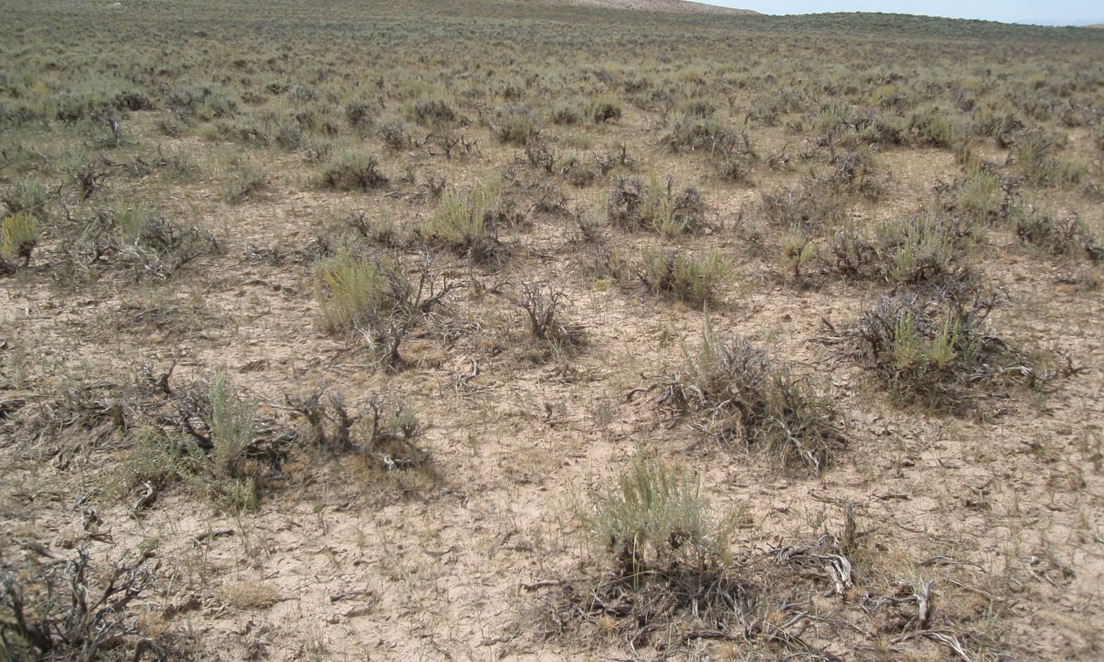
Figure 15. Typical landscape of Wyoming Big Sagebrush/Bare Ground Plant Community. Sublette County, Wyoming.
This plant community is the result of improper grazing. Improper grazing is defined as either high- or low-intensity grazing without the appropriate recovery period. Wyoming big sagebrush dominates with annual production often exceeding 40 percent. There is mostly bare ground between sagebrush plants with an understory of grass and forbs limited to the protected areas under shrubs. The major grasses include Sandberg bluegrass and rhizomatous wheatgrass.
The total annual production (air-dry weight) of this state is about 400 pounds per acre, but it can range from about 200 lbs./acre in unfavorable years to about 600 lbs./acre in above-average years.
Soil erosion is accelerated because of increased bare ground. The biotic community has been compromised but is relatively stable. The watershed is functioning but is at risk of further degradation. Water flow patterns and pedestals are obvious. Infiltration is reduced, and runoff is increased.State 3
DisturbedCommunity 3.1
Rabbitbrush/Rhizomatous Wheatgrass Plant Community
Figure 16. Typical landscape of Rabbitbrush/Rhizomatous Wheatgrass Plant Community. Sublette County, Wyoming.
This plant community is the result of soil-disturbing activities such as hoof action, anthropogenic activity, rodent activity, and frequent flooding, which includes occasional irrigation. It can also occur after brush management followed by improper grazing techniques that usually include high-intensity grazing without appropriate recovery periods. Rhizomatous wheatgrass is the dominant grass. With sagebrush removed, green rabbitbrush will be the dominant shrub, often exceeding 10-20 percent of the annual production. Subdominant understory species include bottlebrush squirreltail, Sandberg bluegrass, and unpalatable annual and perennial forbs. There is a substantial amount of bare ground. The total annual production (air-dry weight) of this state is about 200 pounds per acre, but it can range from about 100 lbs./acre in unfavorable years to about 450 lbs./acre in above-average years. The soil is not protected, and erosion will increase if management is not changed. The biotic integrity may be reduced due to low vegetative production. The watershed is functioning-at-risk.
State 4
Highly DisturbedCommunity 4.1
Annuals Plant CommunityAs part of succession, all ecological sites that are severely disturbed will go through this plant community as part of their restoration. Weather is the largest determining factor in how long a site will be in this plant community phase but is approximately 2-5 years on sites that use Best Management Practices for site restoration (http://www.uwyo.edu/wrrc/). The Clayey Pinedale Plateau ecological site has low potential for recovery. Seeding is needed to restore functional structural groups. Productivity in this plant community phase is highly variable based on the current year's weather, and can range from 100 lbs./ac. or less up to 600 lbs./ac., with representative value of 200 lbs./ac.
Community 4.2
Reclaimed Plant CommunityThis plant community is highly variable based on weather conditions during restoration activities, the management practices used to implement the restoration, the seed mix, and how soil was stockpiled during the disturbance. However, if revegetation is successful, this site has the potential to provide similar productivity to the Reference State. Forage value will depend on the proportion of palatable species for the kind and class of animal in the seed mix, and the successful establishment of seeded forage species.
State 5
PasturelandCommunity 5.1
Dryland Plant CommunitySee Clayey Forage Suitability Group (FSG) for MLRA 34A LRU E (10-14" ppt,
Community 5.2
Irrigated Plant CommunitySee Clayey Forage Suitability Group (FSG) for MLRA 34A LRU E (10-14" ppt,
Transition T1A
State 1 to 2The driver for transition T1A from State 1 (Reference State) to State 2 (<a class="species-link" href="https://plants.usda.gov/core/profile?symbol=2BARE" target="_blank" title="Open in plants.usda.gov"><i>Bare Ground</i></a>) is low to high intensity, long duration, and high frequency herbivory events.
Transition T1B
State 1 to 3The driver for transition T1B from State 1 (Reference State) to State 3 (Disturbed) is an increase in soil-disturbing activity such as hoof action, anthropogenic activity, rodent activity, or occasional flooding.
Transition T1C
State 1 to 4All states will transition to State 4 (Highly Disturbed) when severe soil disturbance occurs (removal of topsoil).
Transition T1D
State 1 to 5All states will transition to State 5 (Pasture) if landuse converted to pasture. Pasture is defined as land composed of introduced or domesticated native forage species that is used primarily for the production of livestock. Pastures receive periodic renovation and cultural treatments, such as tillage, fertilization, mowing, weed control, and may be irrigated. Pastures are not in rotation with crops.
Restoration pathway R2A
State 2 to 1Restoration is possible with sagebrush treatment. Mowing may be the best tool to increase residual and litter in smaller size classes to mulch the site for moisture retention. However, other mechanical tools such as a harrow or aerator should be considered if there is soil crusting and range seeding will be implemented. Chemical treatment could be considered, especially if rabbitbrush densities are higher than desired, but 2,4-DLVE is recommended over tebuthiuron. Tebuthiuron is not recommended due to the high clay content in these soils. Contact the University of Wyoming Extension Service or local Weed & Pest District for appropriate rates and timing. Temporary rest or deferment from grazing is needed to allow an herbaceous response which may take two to several years. If an herbaceous response does not occur or accelerated restoration is desired, a range seeding may be required.
Transition T2A
State 2 to 3The driver for transition T2A from State 2 (<a class="species-link" href="https://plants.usda.gov/core/profile?symbol=2BARE" target="_blank" title="Open in plants.usda.gov"><i>Bare Ground</i></a>) to State 3 (Disturbed) is an increase in soil-disturbing activity such as hoof action, anthropogenic activity, rodent activity, or occasional flooding.
Transition T2B
State 2 to 4All states will transition to State 4 (Highly Disturbed) when severe soil disturbance occurs (removal of topsoil).
Transition T2C
State 2 to 5All states will transition to State 5 (Pasture) if landuse converted to pasture. Pastures receive periodic renovation and cultural treatments, such as tillage, fertilization, mowing, weed control, and may be irrigated. Pastures are not in rotation with crops.
Transition T3A
State 3 to 4All states will transition to State 4 (Highly Disturbed) when severe soil disturbance occurs (removal of topsoil).
Transition T3B
State 3 to 5All states will transition to State 5 (Pasture) if land use converted to pasture. Pasture definition - land composed of introduced or domesticated native forage species that is used primarily for the production of livestock. Pastures receive periodic renovation and cultural treatments, such as tillage, fertilization, mowing, weed control, and may be irrigated. Pastures are not in rotation with crops.
Additional community tables
Table 7. Community 1.1 plant community composition
Group Common name Symbol Scientific name Annual production () Foliar cover (%) Grass/Grasslike1 Perennial Mid-Size Cool Season Grasses 20–60 Letterman's needlegrass ACLE9 Achnatherum lettermanii 6–30 1–5 Indian ricegrass ACHY Achnatherum hymenoides 6–30 1–5 squirreltail ELEL5 Elymus elymoides 0–30 0–5 muttongrass POFE Poa fendleriana 0–30 0–5 bluebunch wheatgrass PSSP6 Pseudoroegneria spicata 0–30 0–5 needle and thread HECO26 Hesperostipa comata 0–30 0–5 2 Rhizomatous Grasses 50–150 thickspike wheatgrass ELLAL Elymus lanceolatus ssp. lanceolatus 60–150 10–25 western wheatgrass PASM Pascopyrum smithii 60–150 10–25 3 Misc. Grasses/Grasslikes 20–60 Sandberg bluegrass POSE Poa secunda 6–60 1–10 plains reedgrass CAMO Calamagrostis montanensis 0–30 0–5 needleleaf sedge CADU6 Carex duriuscula 0–30 0–5 slender wheatgrass ELTR7 Elymus trachycaulus 0–30 0–5 Grass, perennial 2GP Grass, perennial 0–30 0–5 Forb4 Perennial Forbs 16–54 buckwheat ERIOG Eriogonum 6–30 1–5 spiny phlox PHHO Phlox hoodii 6–30 1–5 lupine LUPIN Lupinus 0–30 0–5 aster SYMPH4 Symphyotrichum 0–30 0–5 stemless mock goldenweed STAC Stenotus acaulis 0–18 0–3 ragwort SENEC Senecio 0–18 0–3 fleabane ERIGE2 Erigeron 0–18 0–3 scarlet globemallow SPCO Sphaeralcea coccinea 0–18 0–3 flaxleaf plainsmustard SCLI Schoenocrambe linifolia 0–18 0–3 longleaf phlox PHLO2 Phlox longifolia 0–18 0–3 agoseris AGOSE Agoseris 0–18 0–3 pussytoes ANTEN Antennaria 0–18 0–3 milkvetch ASTRA Astragalus 0–18 0–3 tapertip hawksbeard CRAC2 Crepis acuminata 0–18 0–3 western yarrow ACMIO Achillea millefolium var. occidentalis 0–18 0–3 bluebells MERTE Mertensia 0–18 0–3 beardtongue PENST Penstemon 0–18 0–3 hoary tansyaster MACA2 Machaeranthera canescens 0–18 0–3 hollyleaf clover TRGY Trifolium gymnocarpon 0–6 0–1 deathcamas ZIGAD Zigadenus 0–6 0–1 sagebrush buttercup RAGL Ranunculus glaberrimus 0–6 0–1 western wallflower ERAS2 Erysimum asperum 0–6 0–1 desertparsley LOMAT Lomatium 0–6 0–1 larkspur DELPH Delphinium 0–6 0–1 rockcress ARABI2 Arabis 0–6 0–1 sandwort ARENA Arenaria 0–6 0–1 onion ALLIU Allium 0–6 0–1 Indian paintbrush CASTI2 Castilleja 0–6 0–1 pale bastard toadflax COUMP Comandra umbellata ssp. pallida 0–6 0–1 clover TRIFO Trifolium 0–6 0–1 violet VIOLA Viola 0–6 0–1 cryptantha CRYPT Cryptantha 0–6 0–1 stonecrop SEDUM Sedum 0–6 0–1 Forb, perennial 2FP Forb, perennial 0–6 0–1 5 Annual Forbs 0–6 Forb, annual 2FA Forb, annual 0–6 0–1 bushy bird's beak CORA5 Cordylanthus ramosus 0–6 0–1 rockjasmine ANDRO3 Androsace 0–6 0–1 Shrub/Vine6 Shrubs 80–240 Wyoming big sagebrush ARTRW8 Artemisia tridentata ssp. wyomingensis 120–240 20–40 mountain big sagebrush ARTRV Artemisia tridentata ssp. vaseyana 0–240 0–40 7 Misc Shrubs 10–30 winterfat KRLA2 Krascheninnikovia lanata 0–30 0–5 greasewood SAVE4 Sarcobatus vermiculatus 0–30 0–5 little sagebrush ARARL Artemisia arbuscula ssp. longiloba 0–30 0–5 Gardner's saltbush ATGA Atriplex gardneri 0–30 0–5 yellow rabbitbrush CHVI8 Chrysothamnus viscidiflorus 6–30 1–5 rubber rabbitbrush ERNA10 Ericameria nauseosa 0–18 0–3 spineless horsebrush TECA2 Tetradymia canescens 0–18 0–3 shortspine horsebrush TESP2 Tetradymia spinosa 0–18 0–3 granite prickly phlox LIPU11 Linanthus pungens 0–18 0–3 plains pricklypear OPPO Opuntia polyacantha 0–6 0–1 bud sagebrush PIDE4 Picrothamnus desertorum 0–6 0–1 Table 8. Community 1.2 plant community composition
Group Common name Symbol Scientific name Annual production () Foliar cover (%) Grass/Grasslike1 Perennial Mid-Size Cool Season Bunchgrasses 30–90 Indian ricegrass ACHY Achnatherum hymenoides 30–90 5–15 Letterman's needlegrass ACLE9 Achnatherum lettermanii 30–90 5–15 squirreltail ELEL5 Elymus elymoides 0–60 0–10 muttongrass POFE Poa fendleriana 0–60 0–10 bluebunch wheatgrass PSSP6 Pseudoroegneria spicata 0–30 0–5 needle and thread HECO26 Hesperostipa comata 0–30 0–5 2 Rhizomatous Grasses 70–210 thickspike wheatgrass ELLAL Elymus lanceolatus ssp. lanceolatus 60–210 10–35 western wheatgrass PASM Pascopyrum smithii 60–210 10–35 3 Misc Grasses/Grasslikes 20–60 Sandberg bluegrass POSE Poa secunda 6–60 1–10 plains reedgrass CAMO Calamagrostis montanensis 0–30 0–5 needleleaf sedge CADU6 Carex duriuscula 0–30 0–5 slender wheatgrass ELTR7 Elymus trachycaulus 0–30 0–5 Grass, perennial 2GP Grass, perennial 0–30 0–5 Forb4 Perennial Forbs 16–54 buckwheat ERIOG Eriogonum 6–30 1–5 lupine LUPIN Lupinus 0–30 0–5 aster SYMPH4 Symphyotrichum 0–30 0–5 spiny phlox PHHO Phlox hoodii 6–30 1–5 longleaf phlox PHLO2 Phlox longifolia 0–18 0–3 flaxleaf plainsmustard SCLI Schoenocrambe linifolia 0–18 0–3 ragwort SENEC Senecio 0–18 0–3 scarlet globemallow SPCO Sphaeralcea coccinea 0–18 0–3 stemless mock goldenweed STAC Stenotus acaulis 0–18 0–3 fleabane ERIGE2 Erigeron 0–18 0–3 hoary tansyaster MACA2 Machaeranthera canescens 0–18 0–3 bluebells MERTE Mertensia 0–18 0–3 beardtongue PENST Penstemon 0–18 0–3 tapertip hawksbeard CRAC2 Crepis acuminata 0–18 0–3 western yarrow ACMIO Achillea millefolium var. occidentalis 0–18 0–3 agoseris AGOSE Agoseris 0–18 0–3 pussytoes ANTEN Antennaria 0–18 0–3 milkvetch ASTRA Astragalus 0–18 0–3 Indian paintbrush CASTI2 Castilleja 0–6 0–1 pale bastard toadflax COUMP Comandra umbellata ssp. pallida 0–6 0–1 rockcress ARABI2 Arabis 0–6 0–1 Forb, perennial 2FP Forb, perennial 0–6 0–1 sandwort ARENA Arenaria 0–6 0–1 onion ALLIU Allium 0–6 0–1 cryptantha CRYPT Cryptantha 0–6 0–1 larkspur DELPH Delphinium 0–6 0–1 western wallflower ERAS2 Erysimum asperum 0–6 0–1 desertparsley LOMAT Lomatium 0–6 0–1 hollyleaf clover TRGY Trifolium gymnocarpon 0–6 0–1 clover TRIFO Trifolium 0–6 0–1 violet VIOLA Viola 0–6 0–1 deathcamas ZIGAD Zigadenus 0–6 0–1 stonecrop SEDUM Sedum 0–6 0–1 sagebrush buttercup RAGL Ranunculus glaberrimus 0–6 0–1 5 Annual Forbs 0–6 Forb, annual 2FA Forb, annual 0–6 0–1 rockjasmine ANDRO3 Androsace 0–6 0–1 bushy bird's beak CORA5 Cordylanthus ramosus 0–6 0–1 Shrub/Vine6 Shrubs 40–120 Wyoming big sagebrush ARTRW8 Artemisia tridentata ssp. wyomingensis 30–120 5–20 mountain big sagebrush ARTRV Artemisia tridentata ssp. vaseyana 0–120 0–20 7 Misc Shrubs 20–60 little sagebrush ARARL Artemisia arbuscula ssp. longiloba 0–30 0–5 Gardner's saltbush ATGA Atriplex gardneri 0–30 0–5 yellow rabbitbrush CHVI8 Chrysothamnus viscidiflorus 6–30 1–5 winterfat KRLA2 Krascheninnikovia lanata 0–30 0–5 greasewood SAVE4 Sarcobatus vermiculatus 0–30 0–5 spineless horsebrush TECA2 Tetradymia canescens 0–18 0–3 shortspine horsebrush TESP2 Tetradymia spinosa 0–18 0–3 granite prickly phlox LIPU11 Linanthus pungens 0–18 0–3 rubber rabbitbrush ERNA10 Ericameria nauseosa 0–18 0–3 plains pricklypear OPPO Opuntia polyacantha 0–6 0–1 bud sagebrush PIDE4 Picrothamnus desertorum 0–6 0–1 Table 9. Community 2.1 plant community composition
Group Common name Symbol Scientific name Annual production () Foliar cover (%) Table 10. Community 3.1 plant community composition
Group Common name Symbol Scientific name Annual production () Foliar cover (%) Table 11. Community 4.1 plant community composition
Group Common name Symbol Scientific name Annual production () Foliar cover (%) Table 12. Community 4.2 plant community composition
Group Common name Symbol Scientific name Annual production () Foliar cover (%) Table 13. Community 5.1 plant community composition
Group Common name Symbol Scientific name Annual production () Foliar cover (%) Table 14. Community 5.2 plant community composition
Group Common name Symbol Scientific name Annual production () Foliar cover (%) Interpretations
Animal community
The following table lists suggested stocking rates for cattle under continuous season-long grazing under normal growing conditions with a harvest efficiency (HE) of 25 percent. These are conservative estimates that should be used only as guidelines in the initial stages of the conservation planning process. Often, the current plant composition does not entirely match any particular plant community (as described in this ecological site description). A field visit is required to document actual plant composition and production. More precise carrying capacity estimates, considering forage preference and accessibility (slope, distance to water, etc.), should be calculated using this information, particularly when grazers other than cattle are involved. Under more intensive grazing management, improved harvest efficiencies (up to 35 percent) can result in an increased carrying capacity, but recovery time for upland sites is much longer. If distribution problems occur, stocking rates should be reduced or facilitating conservation practices (i.e., cross-fencing, water development) implemented to maintain plant health and vigor.
Stocking rates are expressed in Animal Unit Months (AUMs) which is defined as the amount of forage consumed by a 1,000 lb. cow with a less than 4 month old calf at her side.
Plant Community Production (lbs./ac.) Initial Suggested Stocking Rate (AUMs/ac.)* Ac./AUM
1.1 ARTRW8/ELLAL 400-600-800 0.07 14
1.2 ELLAL 400-600-800 0.1 10
2.1 ARTRW8/BG 200-400-600 0.03 33
3.1 CHVI8/ELLAL 100-200-450 0.05 20
4.1 Annuals 100-300-600 0.04 24
4.2 Reclaimed 400-600-800 0.08 13
5.1 Dryland Pasture 500-700-900 0.19 5
5.2 Irrigated Pasture 2000-3000-4000 0.82 1.25
* Continuous, season-long grazing by cattle under average growing conditions.
Calculation for stocking rates are as follows: Using RV values for production, take forage palatable to grazing cattle and multiply by 0.25 HE and divide by 912.5 lbs./AUM air-dry weight (ADW) to arrive at the initial suggested stocking rate in AUMs/acre.
Grazing by domestic livestock is one of the major income-producing industries in the area. Rangeland in this area may provide year-long forage for cattle, sheep, or horses. During the dormant period, the forage for livestock must be supplemented with protein because the quality does not meet minimum livestock requirements.
Distance to water, shrub density, and slope can affect grazing capacity within a management unit. Adjustments should be made for the area that is considered necessary for reduction of animal numbers. For example, 30 percent of a management unit may have 25 percent slopes and distances of greater than one mile from water; therefore the adjustment is calculated for 30 percent of the unit (i.e. 50 percent reduction on 30 percent of the management unit). Fencing, slope length, management, access, terrain, kind and class of livestock, and breeds are all factors that can increase or decrease the percent of grazeable acres within a management unit. Adjustments should be made that incorporate these factors when calculating stocking rates.
Wildlife:
Reference State:
1.1 WY Big Sagebrush/Perennial Grass: This community phase provides good transitional and summer habitat for greater sage-grouse, mule deer, pronghorn, and elk. Suitable thermal and escape cover for mule deer exists. A diverse suite of herbaceous species also provide important micronutrient requirements for big game species throughout the year. These areas also provide high quality bird-nesting habitat where sagebrush canopy and residual bunchgrasses hide nests and young from predators. This community can be used as migration and stopover habitat by big game, but is generally a small component of the landscape. Spring green-up of grass is an important nutritional component of this community for migrating big game.
1.2 Rhizomatous Wheatgrass: Suitable thermal and escape cover for mule deer and pronghorn may be limited due to the low density of woody plants. However, sagebrush is a very important winter forage for mule deer and antelope. Year-round habitat is provided for greater sage-grouse and many other sagebrush obligate species such as sage sparrow, Brewer’s sparrow, sage thrasher, pygmy rabbit, sagebrush vole, horned lizard, and pronghorn. Open spaces in sagebrush canopy are potential sage grouse lek locations. Other birds that would frequent this plant community include horned larks and golden eagles.
2. Bare Ground
2.1 WY Big Sagebrush/Bare Ground: This community phase provides potential foraging habitat for big game and greater sage-grouse when the sagebrush plants are in a healthy condition. If the sagebrush is old and has poor leader production, it may not be providing quality forage for browsing animals. The lack of herbaceous species limits the species diversity, thus the value of the site for birds and small mammals is likely less than the Reference State due to the lack of cover in the interspaces of the sagebrush plants. The lack of plant diversity also limits the diversity of insects used by wildlife species.
3. Disturbed: These communities provide limited forage for pronghorn and mule deer due to low production and lack of sagebrush. They may be used as a foraging site by sage grouse if proximal to woody cover, or seasonally used by cottontail or jack rabbits. The overall dominance of rabbitbrush is generally not ideal to support a wide variety of wildlife.
4. Highly Disturbed State:
4.1 Annuals: This community phase is highly variable in its value to wildlife. It typically is less diverse, has lower forage value, and has limited structure that wildlife need for cover. This state is vulnerable to repeated disturbance which can result in a complete loss of value for wildlife. In addition, sites in this state are more susceptible to invasion of non-native species, further degrading the value for wildlife.
4.2 Reclaimed: This community phase is highly variable in its value to wildlife. Reclamation success, size and configuration of the reclaimed area, the species planted, and the time it takes for plants to establish will determine the value of the site for wildlife. A fully reclaimed site containing a diversity of herbaceous and woody native plants can eventually provide the same wildlife habitat benefits as the Reference State. In most cases, grasses and forbs establish early in the reclamation process, whereas shrubs take significantly longer to establish. Wildlife species dependent upon herbaceous plant communities for forage will benefit from reclamation sooner than those species dependent upon a mixed shrub/grass community. Suitable habitat for wildlife species that require tall, dense sagebrush (greater sage-grouse, pronghorn, mule deer, and sagebrush obligate songbirds) will likely take several decades to achieve providing appropriate shrub species were planted. It is possible to achieve successful, diverse reclamation on linear disturbances (i.e., pipelines) without seeding shrubs, but it will likely take longer than a decade for seed from shrubs adjacent to the area to establish on-site.Hydrological functions
Water is the principal factor limiting forage production on this site. This site is dominated by soils in hydrologic group C, with localized areas in hydrologic group D. Infiltration ranges from very slow to moderately slow. Runoff potential for this site varies from moderate to high, depending upon soil hydrologic group and ground cover. In many cases, lesser sloping areas with greater than 75 percent ground cover have the greatest potential for high infiltration and lower runoff. Greater sloping areas where ground cover is less than 50 percent have the greatest potential to have reduced infiltration and higher runoff (refer to Part 630, NRCS National Engineering Handbook for detailed hydrologic information).
Rills and gullies should not typically be present. Water flow patterns should be barely distinguishable if at all present. Pedestals are only slightly present in association with bunchgrasses and shrubs. Litter typically falls in place, and signs of movement are not common. Chemical and physical crusts are sometimes present on this site.Recreational uses
This site provides some limited recreational opportunities for hiking, horseback riding, bird watching, and upland game hunting. The forbs have a variety of colors and shapes that appeal to photographers. This site provides valuable open space when located in large, unfragmented landscapes.
Wood products
No wood products are associated with the Clayey Pinedale Plateau ecological site.
Other products
No other products are associated with the Clayey Pinedale Plateau ecological site.
Other information
Site is provisional (2019). History of site development: Range Site Clayey Foothills and Basins West (Cy 10-14W) published in 1988. Site converted to provisional Ecological Site Description in 2005 (pdf format) and entered into ESIS. Range health reference worksheet completed in 2007. Pinedale Plateau LRU designation occurred in 2012. Site concept updated for new LRU designation (provisional status) in 2019.
Supporting information
Inventory data references
Information presented was derived from: 1988 Range Site Descriptions - Clayey Foothills and Basins West (10-14W) MLRA 34A Cool Desertic Basins and Plateaus, historic NRCS clipping data, literature , Sublette Soil Survey field observations (based on five paired plot sampled sites in 2018 in the Reference State), observations from numerous others, and personal contacts with range-trained personnel (i.e., agency specialists, landowners, land managers, and scientists).
References
-
. 2021 (Date accessed). USDA PLANTS Database. http://plants.usda.gov.
-
1980. USNVC [United States National Vegetation Classification]. 2019. United States National Vegetation Classification Database, V2.03. Federal Geographic Data Committee, Vegetation Subcommittee, Washington DC.. USNVC: http://usnvc.org/.
-
. 1997. Introduction to Microbiotic Crusts. Natural Resources Conservation Service.
-
. 2002. Management considerations for sagebrush (Artemisia) in the western U.S.: A selective summary of cumulative information about the ecology and biology of woody N. American sagebrush taxa. USDI-BLM, Washington, D.C..
-
Bestelmeyer, B., J.R. Brown, K.M. Havstad, B. Alexander, G. Chavez, and J.E. Herrick. 2003. Development and Use of State and Transition Models for Rangelands. Jornal of Range Management 56:114–126.
-
Bestelmeyer, B., J.R. Brown, J.E. Herrick, D.A. Trujillo, and K.M. Havstad. 2004. Land Management in the American Southwest: a state-and-transition approach to ecosystem
complexity. Environmental Management 34:38–51. -
Bestelmeyer, B. and J. Brown. 2005. State-and-Transition Models 101: A Fresh look at vegetation change.
-
Bukowski, B.E. and W.L. Baker. 2013. Historical fire regimes, reconstructed from land-survey data, led to complexity and fluctuation in sagebrush landscapes. Ecological Applications 23:546–564.
-
Cagney, J., E. Bainter, B. Budd, T. Christiansen, V. Herren, and M. Holloran. 2010. Grazing Influence, Objective Development, and Management in Wyoming's Greater Sage-Grouse Habitat. 35p.
-
Chambers, J.C., J.L. Beck, T.J. Christiansen, K.J. Clause, J.B. Dinkins, K.E. Doherty, K.A. Griffin, D.W. Havlina, K.F. Henke, L.L. Kurth, J.D. Maestas, M. Manning, K.E. Mayer, B.A. Mealor, C. McCarthy, M.A. Perea, and D.A. Pyke. 2016. Using resilience and resistance concepts to manage threats to sagebrush ecosystems, Gunnison sage-grouse, and Greater sage-grouse in their eastern range: A strategic multi-scale approach.. Gen. Tech. Rep. RMRS-GTR-356.. U.S. Department of Agriculture, Forest Service, Rocky Mountain Research Station, Fort Collins, CO. 1–143.
-
Clause, K. and J. Randall. 2014. Wyoming Sagebrush Die-Off Report. Unpublished.
-
Derner, J.D., G.E. Schuman, R.F. Follett, and G.F. Vance. 2013. Plant and Soil Consequences of Shrub Management in a Big Sagebrush-Dominated Rangeland Ecosystem.
-
Miller, J.F., R.H. Frederick, and R.J. Tracey. 1973. “Precipitation-Frequency Atlas of the United States” NOAA Atlas 2, Volume 2 (Wyoming). National Weather Service, Silver Spring, Maryland.
-
Rosentrater, R., M. Bowker, and J. Belnap. 2007. A Field Guide to Biological Soil Crusts of the Western U.S. Drylands. U.S. Government Printing Office, Denver, Colorado.
-
Shultz, L.M. 2009. Monograph of Artemisia Subgenus Tridentatae (Asteraceae-Anthemideae). Systematic Botany Monographs 89:1–131.
-
Sommers, J. 1994. Green River Drift- A History of the Upper Green River Cattle Association.
-
Stiver, S., E. Rinkes, and D. Naugle. 2010. Sage-Grouse Habitat Assessment Framework. 6p.
-
Stringham, T.K., W.C. Kreuger, and P.L. Shaver. 2003. State and Transition Modeling: an ecological process approach. Journal of Range Management 56:106–113.
-
U. S. Environmental Protection Agency. 2010. Level III and IV ecoregions of the continental United States. U.S. EPA, National Health and Environmental Effects Research Laboratory, Corvallis, Oregon, U.S..
-
Winward, A. 2007. Boulder, Squaretop Area Field Notes. Field Notes. Unpublished.
Contributors
Bryan Christensen
Karen J. ClauseApproval
Kirt Walstad, 4/15/2025
Rangeland health reference sheet
Interpreting Indicators of Rangeland Health is a qualitative assessment protocol used to determine ecosystem condition based on benchmark characteristics described in the Reference Sheet. A suite of 17 (or more) indicators are typically considered in an assessment. The ecological site(s) representative of an assessment location must be known prior to applying the protocol and must be verified based on soils and climate. Current plant community cannot be used to identify the ecological site.
Author(s)/participant(s) Karen Clause and Bryan Christensen John Hartung Jim Haverkamp Ryan Murray Jeff Fenton Blaise Allen Contact for lead author karen.clause@usda.gov; 307-367-2257 Date 04/30/2019 Approved by Approval date Composition (Indicators 10 and 12) based on Annual Production Indicators
-
Number and extent of rills:
None to Rare. Some very minor rills (less than 12 in. or 30 cm) may occur after a major thunderstorm event or spring runoff. Rills may also occur in areas of greater slope (>8%) and adjacent to areas with exposed bedrock, but should heal during the following growing season -
Presence of water flow patterns:
Barely observable. Some minor evidence of water flow patterns may be found winding around perennial plant bases with little evidence of erosion and they are short; less than 6 ft (2 m) long, less than 1 ft (30 cm) wide, and disconnected. -
Number and height of erosional pedestals or terracettes:
None to Rare. Pedestals may occur on slopes greater than 8%. Roots are not exposed with blunted features and are not active. -
Bare ground from Ecological Site Description or other studies (rock, litter, lichen, moss, plant canopy are not bare ground):
Bare ground is typically 15% - 30%. Bare ground is scattered throughout this site and patches are not connected. Higher bare ground is expected after a sagebrush killing event, but returns to less than 30% within 2 years post disturbance. -
Number of gullies and erosion associated with gullies:
Active gullies should not be present. -
Extent of wind scoured, blowouts and/or depositional areas:
Rare to nonexistent. -
Amount of litter movement (describe size and distance expected to travel):
Herbaceous litter expected to move only in short distances (to leeward side of shrubs) due to wind. Large woody debris from sagebrush will show no movement. -
Soil surface (top few mm) resistance to erosion (stability values are averages - most sites will show a range of values):
Soil Stability Index ratings range from 2 in the interspaces to 6 under plant canopy, but average values should be 4.0 or greater. -
Soil surface structure and SOM content (include type of structure and A-horizon color and thickness):
Soil organic matter (SOM) <2% is common. Color and structure are difficult indicators to assess in semiarid soils because SOM potential is naturally low. Typically, the soil surface consists of an A-horizon of 1-6 inches (3-16 cm) thick with strong medium granular structure and a subsurface that is medium to strong subangular blocky or prismatic structure. The surface is typically brown to grayish brown (i.e. 10YR 4/3 to 5/2) with a similar colored subsurface. Field indicators of departure from the reference condition include exposure of subsoil as evidenced by excessive pedestalling and/or surface disturbance. -
Effect of community phase composition (relative proportion of different functional groups) and spatial distribution on infiltration and runoff:
Plant community composition by dry weight consists of 45-60% grasses, 10% forbs, and 30-45% shrubs. Evenly distributed plant canopy (30-50% foliar cover), litter and moderately slow to very slow permeability result in slight runoff. The shrub component is important for snow trapping and the herbaceous component is important for reducing runoff from short intense thunderstorms. Basal cover is typically less than 5% for this site and does very little to effect runoff on this site. -
Presence and thickness of compaction layer (usually none; describe soil profile features which may be mistaken for compaction on this site):
None, but soil cracking and crusting in dry conditions is typical. Soil probe refusal may result in a mis-identification of a compaction layer, and must be described by hand dug holes. -
Functional/Structural Groups (list in order of descending dominance by above-ground annual-production or live foliar cover using symbols: >>, >, = to indicate much greater than, greater than, and equal to):
Dominant:
1.1 sagebrush (1 species) 1.2 rhizomatous grasses (2 species)Sub-dominant:
1.1 rhizomatous grasses (2 species) 1.2 sagebrush (1 species)Other:
Minor: 1.1 mid-size cool season bunchgrasses (2 species) short, cool season bunchgrasses (1 species) perennial forbs (2 species) sprouting shrubs (1 species) 1.2 mid-size cool season bunchgrasses (2 species) short, cool season bunchgrasses (2 species) sprouting shrubs (1 species) perennial forbs (2 species) Trace: annual forbs (2 species)Additional:
12a. Relative dominance of functional/structural groups. 1.1 mid-size cool season bunchgrasses > short, cool season bunchgrasses > perennial forbs > sprouting shrubs >> annual forbs 1.2 mid-size cool season bunchgrasses > short, cool season bunchgrasses = sprouting shrubs > perennial forbs >> annual forbs 12b. Functional/Structural groups not expected: annual grasses 12c. Number for functional/structural groups: 7 12d. Number of species in dominant/sub-dominant f/s groups: 3 -
Amount of plant mortality and decadence (include which functional groups are expected to show mortality or decadence):
Minimal decadence, typically associated with shrub component. -
Average percent litter cover (%) and depth ( in):
Litter ranges from 15-40% of total canopy measurement with total litter (including beneath the plant canopy) from 45-70% expected. Herbaceous litter depth typically ranges from 1-5mm. Woody litter can be up to 1-2.5 inches (4-6 cm) in diameter. -
Expected annual annual-production (this is TOTAL above-ground annual-production, not just forage annual-production):
English: 400-800 lb/ac (600 lb/ac average); Metric 448-897 kg/ha (673 kg/ha average). 1.1 PERENNIAL MID-SIZE COOL SEASON GRASSES (5-10%) RHIZOMATOUS GRASSES (10-25%) MISC. GRASSES/GRASSLIKES (5-10%) PERENNIAL FORBS (5-9%) ANNUAL FORBS (0-1%) SAGEBRUSH (20-40%) MISC. SHRUBS (0-5%) 1.2 PERENNIAL MID-SIZE COOL SEASON GRASSES (5-15%) RHIZOMATOUS GRASSES (10-35%) MISC. GRASSES/GRASSLIKES (5-10%) PERENNIAL FORBS (5-9%) ANNUAL FORBS (0-1%) SAGEBRUSH (5-20%) MISC. SHRUBS (5-10%) -
Potential invasive (including noxious) species (native and non-native). List species which BOTH characterize degraded states and have the potential to become a dominant or co-dominant species on the ecological site if their future establishment and growth is not actively controlled by management interventions. Species that become dominant for only one to several years (e.g., short-term response to drought or wildfire) are not invasive plants. Note that unlike other indicators, we are describing what is NOT expected in the reference state for the ecological site:
Annual weeds such as halogeton, kochia, mustards such as desert alyssum and flixweed, lambsquarter, and Russian thistle are common species to invade disturbed sites. Cheatgrass (<a class="species-link" href="https://plants.usda.gov/core/profile?symbol=BRTE" target="_blank" title="Open in plants.usda.gov"><i>Bromus tectorum</i></a>) and hoary alyssum (Berteroa incana) are emerging invasive species to this LRU, but have not been found on this site. Other noxious weeds that could potentially invade this site: Canada thistle (<a class="species-link" href="https://plants.usda.gov/core/profile?symbol=CIAR4" target="_blank" title="Open in plants.usda.gov"><i>Cirsium arvense</i></a>) and whitetop (<a class="species-link" href="https://plants.usda.gov/core/profile?symbol=CADR" target="_blank" title="Open in plants.usda.gov"><i>Cardaria draba</i></a>). Greasewood (Sarcobatus vermiculatous) is a native shrub that can encroach from adjacent salt affected sites. -
Perennial plant reproductive capability:
All species are capable of reproducing, except in drought years. Thickspike wheatgrass will commonly reproduce by underground rhizomes and not by seed production.
Print Options
Sections
Font
AAAAOther
PrintThe Ecosystem Dynamics Interpretive Tool is an information system framework developed by the USDA-ARS Jornada Experimental Range, USDA Natural Resources Conservation Service, and New Mexico State University.
Accessibility statement


