
Natural Resources
Conservation Service
Ecological site R030XY227CA
Sandy Thermic Narrow Channels
Last updated: 10/21/2024
Accessed: 08/18/2026
-
Search


Major Land Resource Area or ecological site by name and/or ID.
PreviousSectionsNextGeneral information
Provisional. A provisional ecological site description has undergone quality control and quality assurance review. It contains a working state and transition model and enough information to identify the ecological site.
MLRA notes
Major Land Resource Area (MLRA): 030X–Mojave Basin and Range
MLRA statement:
Major Land Resource Area (MLRA) 30, Mojave Desert, is found in southern California, southern Nevada, the extreme southwest corner of Utah and northwestern Arizona within the Basin and Range Province of the Intermontane Plateaus. The climate of the area is hot (primarily hyperthermic and thermic; however at higher elevations, generally above 5000 feet, mesic, cryic and frigid) and dry (aridic). Elevations range from below sea level to over 12,000 feet in the higher mountain areas found within the MLRA. Due to the extreme elevational range found within this MLRA, LRUs were designated to group the MLRA into similar land units.
XY Land Resource Unit (LRU):
This LRU is found throughout the Mojave Desert MLRA. This LRU designation is set aside for ecological sites that are driven by environmental or chemical features that override the climatic designations of the other LRU’s or are atypical compared to the surrounding landscape. Common overriding XY characteristics within this MLRA include: ephemeral streams subject to flash flood events, riparian areas or other water features, and soils with strong chemical influence (Na, Ca, etc).
Ecological site concept
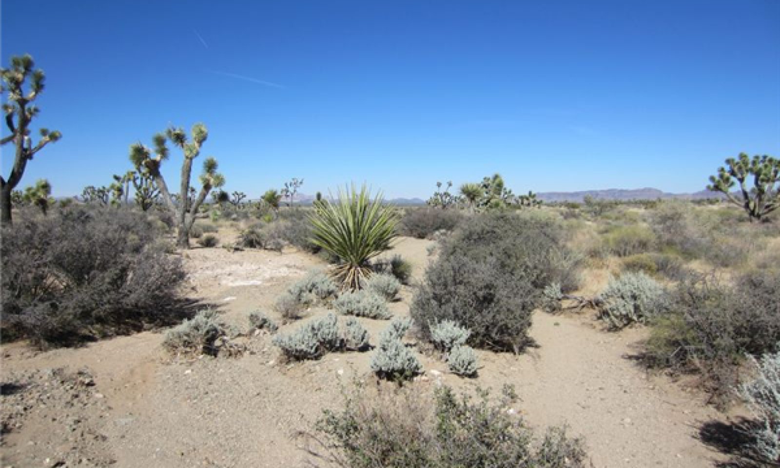
This ecological site occurs on gently sloping, narrow, first and occasionally second order ephemeral drainageways in the eastern Mojave Desert. This site has developed in response to frequent, low-intensity flash flood events from runoff from adjacent fan remnants and hills. Soils are very deep sands with little soil development. Increased water availability due to flooding and greater water storage in the deep sands increases the productivity and diversity of this site relative to adjacent uplands. The rare eastern Mojave endemic, Mojave desert plum (Prunus eremophila) is a characteristic species of this ecological site. Other important species include catclaw acacia (Acacia greggii), purple sage (Salvia dorrii), big galleta (Pleuraphis rigida), and bush muhly (Muhlenbergia porteri).
Associated sites
R030XB107NV COARSE GRAVELLY LOAM 5-7 P.Z.
This site occurs on adjacent fan remnant footslopes with occasional flooding.
R030XB231CA Shallow To Moderately Deep Petrocalcic Fan Remnants (Provisional)
This site occurs on adjacent fan remnants. Creosote bush (Larrea tridentata), winterfat (Krascheninnikovia lanata), and burrobush (Ambrosia dumosa) are dominant species.
Similar sites
R030XY202CA Very Rarely To Rarely Flooded Thermic Ephemeral Stream
This ecological site occurs on Torripsamments in the western Mojave Desert with less summer precipitation. California jointfir (Ephedra californica), burrobush, and Mojave indigobush (Psorothamnus arborescens) are dominant species and Mojave desert plum is not present.
R030XY188CA Slightly Alkaline, Rarely To Occasionally Flooded Ephemeral Stream
This site occurs at lower elevations. Hall's shrubby spurge (Tetracoccus hallii) is a dominant species and Mojave desert plum is not present.
R030XY219CA Ustic Ephemeral Drainageway Order 3
This site occurs on much larger, more complex drainageways. Mojave desert plum is not present.
R030XY220CA Ustic Ephemeral Drainageways Order 2
This ecological site occurs on larger order drainageways, and has a greater complexity of community components. Mojave desert plum is not present.
Table 1. Dominant plant species
Tree Not specified
Shrub (1) Prunus eremophila
(2) Acacia greggiiHerbaceous (1) Pleuraphis rigida
(2) Muhlenbergia porteriPhysiographic features
This ecological site occurs on narrow, gently sloping, first and second order ephemeral drainageways. Elevations range from 3410 to 3870 feet, and slopes range from 1 to 4 percent. These drainageways experience frequent flash-flooding from runoff in adjacent hills. Runoff class within drainageways is negligible.
Table 2. Representative physiographic features
Landforms (1) Wash
Flooding frequency Frequent Elevation 3400 – 3900 ft Slope 1 – 4 % Climatic features
Eastern Mojave Desert
Table 3 Representative climatic features
Frost-free period (average) 320 days Freeze-free period (average) Precipitation total (average) 180 in ">Influencing water features
This ecological site is associated with order 1 and 2 ephemeral stream systems, and includes all associated landforms.<br />
Soil features
The soils associated with this site are very deep, sandy soils formed in alluvium from metamorphic and sedimentary rock. They are somewhat excessively drained with rapid permeability. They have minimal soil development. Surface textures are sand and subsurface textures (from depths of 1 to 59 inches) are sand and loamy sand. The surface cover of rock fragments less than 3 inches in diameter averages 25 percent and surface rock fragments greater than 3 inches are negligible. Subsurface rock fragments (from depths of 1 to 59 inches) less than 3 inches in diameter average 9 percent by volume and rock fragments greater than 3 inches are negligible.
This ecological site is associated with the following soil series: Morongo (mixed, thermic Typic Torripsamments).
This ecological site has been correlated with the following mapunits and soil components in the Mojave National Preserve soil survey area (CA795):
208 ; Bluesnake loamy sand, 1 to 4 percent slopes ; Morongo ; frequently flooded ; 1
Table 4. Representative soil features
Surface texture (1) Sand
Family particle size (1) Sandy
Drainage class Somewhat excessively drained Permeability class Rapid Soil depth 60 – 0 in Surface fragment cover <=3" 25 % Surface fragment cover >3" Not specified Available water capacity
(0-40in)1.6 – 3.1 in Calcium carbonate equivalent
(0-40in)0 – 1 % Electrical conductivity
(0-40in)0 – 2 mmhos/cm Sodium adsorption ratio
(0-40in)0 – 5 Soil reaction (1:1 water)
(0-40in)6.6 – 7.8 Subsurface fragment volume <=3"
(Depth not specified)9 % Subsurface fragment volume >3"
(Depth not specified)Not specified Ecological dynamics
This ecological site occurs on gently sloping, narrow, first and occasionally second order ephemeral drainageways in the eastern Mojave Desert. These drainageways receive frequent flash flooding from runoff from adjacent fan remnants and hills. Soils are very deep sands with little soil development. Ephemeral drainageways, even small ones such as this ecological site, are ecologically important components of arid ecosystems where water is the principal limiting resource (e.g. Schlesinger and Jones 1984, Levick et al. 2008, Schwinning et al. 2010). Small drainage systems direct the flow of surface water, thereby temporarily increasing water availability during flooding (Schwinning et al. 2010). Very deep coarse-textured soils also act to store water in arid ecosystems (Noy-Meir 1973), so the temporal availability of water is higher in ephemeral drainageways than surrounding uplands (Schwinning et al. 2010). This increase in the amount and availability of water increases the productivity and cover of vegetation in these systems relative to adjacent uplands, and allows for a xeroriparian plant community to occur (Levick et al. 2008). The xeroriparian community is comprised of drought-tolerant species that also may occur on upland sites, but is more productive, has higher cover, and is typically more diverse than adjacent upland sites.
Soil disturbance from flash flood events is the primary driver of plant community dynamics within this ecological site. Ephemeral streams lack permanent flow except in response to rainfall events (Balling and Wells 1990, Bull 1997, Levick et al. 2008). These ephemeral streams are characterized by extreme and rapid variations in flooding regime, and a high degree of temporal and spatial variability in hydrologic processes (Bull 1997, Stanley et al. 1997, Levick et al. 2008, Shaw and Cooper 2008). Physical disturbance of soils as a result of flash flooding makes predictability of the plant community low except when considered at a coarse scale. Typical runoff events may result in an apparently stable mosaic of plant species distribution, while more extreme events may completely reconfigure the mosaic and establish the foundation of a new or modified plant community mosaic until the next extreme runoff event occurs.
The vegetation of this ecological site consists of a unique xeroriparian assemblage. All species occurring on the site may occur in upland habitats. The rare eastern Mojave Desert endemic (CNPS Inventory of Rare and Endangered Plants on list 1B.2) Mojave desert plum is a characteristic species of this ecological site. Mojave desert plum was described as a new species in 2002 (Prigge 2002), and is known only from the Vontrigger Hills area of the Mojave National Preserve (Consortium of California Herbaria (ucjeps.berkeley.edu/consortium/). Mojave desert plum habitat is typically small ephemeral drainageways, but it may also occur on adjacent hills. This species is thought to be a neo-endemic, recently evolved from the more common desert almond (Prunus fasciculata), which occurs in similar habitats, but little is known about the ecology of P. eremophila. Further data collection on the abiotic factors characteristic of Mojave desert plum habitat versus desert almond habitat is required, as is research into how these two species differ ecologically.
Other characteristic species include catclaw acacia (Acacia gregii), purple sage (Salvia dorrii), and big galleta (Pleuraphis rigida). Catclaw acacia usually reaches dominance only where there is regular flooding, or where surface fragments channel water (Sawyer et al. 2009). Purple sage and big galleta frequently occur on upland habitats, but are often abundant on disturbed soils, or soils receiving additional run-on.
Disturbances such as drought, fire, and human hydrologic alterations can affect the community composition and/or hydrologic process of this ecological site. Episodic drought is characteristic of the desert (Hereford et al. 2006), and can cause mortality or die-back of vegetation. Decreased vegetative cover can lead to increase in erosion and change sediment deposition patterns, possibly increasing the chance of channel migration. Historically fire was very uncommon in these ephemeral drainages, and since the dominant species of this site recover rapidly or increase in response to fire, fire is not considered a direct threat to this ecological site. However the presence of continuous and flashy fuels from non-native grasses in adjacent upland sites has increased the frequency of fire in adjacent communities (Brooks 1999, 2005, Brooks et al. 2007, DeFalco et al. 2010, Brooks 2011, Engel and Abella 2011), and loss of vegetation cover in these hills can contribute to increased flooding and sediment deposition in this ecological site. This could have a number of effects, including increased scouring of xeroriparian vegetation within the drainage channels causing temporary decreases in vegetative cover; widening of channels, which would increase the complexity of plant communities in the ecological site (i.e. areas receiving different flooding intensity or frequency would be dominated by different suites of species); sediment deposition could cause channel avulsion; abandoned channels would be less suitable to support the vegetation of this ecological site.State and transition model
Custom diagramStandard diagram
Figure 1. R030XY227CA
More interactive model formats are also available. View Interactive Models
More interactive model formats are also available. View Interactive Models
Click on state and transition labels to scroll to the respective textEcosystem states
State 1 submodel, plant communities
State 1
ReferenceCommunity 1.1
Reference Community
Figure 2. Community Phase 2.1
At any given point along the stream the following community components are generally present. The relative spatial extent of these communities varies as the channel morphology fluctuates from flash flood events. Steeper reaches may be more incised with less chance of sheet flow over the banks. In lower slope reaches sediment fills the main channel, increasing the chance of sheet flow across the area. Areas with sheet flow have a higher area of surface disturbance and will have more disturbance dependent species.
Two community components are present, including:
Community Component 1 (CC1) Active Channel
This area is dominated by barren gravels and sand. There is very little vegetation in this zone due to frequent scouring from floods.
Community Component 2 (CC2) Channel Margins and Bars
This community occurs on low relief bars within the channel and on channel margins. It is dominated by Mojave desert plum. Purple sage, catclaw acacia, peachthorn (Lycium cooperi), big galleta, burrobush (Hymenoclea salsola), bush muhly (Muhlenbergia porteri) and other mixed shrubs and forbs are also present.
Figure 3. Annual production by plant type (representative values) or group (midpoint values)
Table 5. Annual production by plant type
Plant type Low
(lb/acre)Representative value
(lb/acre)High
(lb/acre)Shrub/Vine 200 300 400 Grass/Grasslike 100 160 215 Forb 40 50 75 Total 340 510 690 Community 1.2
Channel infilling [Provisional]This community phase is characterized by channel infilling and narrowing, and an increase in vegetation. It typically occurs late in the recurrence interval between large flooding events, when repeated smaller floods have resulted in sediment deposition, and existing vegetation has spread within the channel and trapped further sediment in channel bars. Upland species are likely to become more prevalent as they colonize more stable areas.
This phase is most susceptible to a channel altering large magnitude flood because of the reduced flow capacity in narrower channels. If accompanied by drought there will be an overall decline in vegetation and an increase in bare ground, making this phase highly susceptible to scouring and channel incision with a severe flood event.
Community 1.3
Large magnitude flood [Provisional]This community phase develops in response to intense flooding, which scours vegetation in and along the channel. Most small and shallow rooted species, such as purple sage, perennial grass species, and perennial forbs, are removed, as are some deep rooted species such as Mojave desert plum and catclaw acacia. Mojave desert plum and catclaw acacia quickly resprout from the root base in response to mechanical damage. Shallow rooted species will colonize from seed relatively quickly.
Pathway 1.1a
Community 1.1 to 1.2This pathway occurs with time without a large magnitude flood event.
Pathway 1.1b
Community 1.1 to 1.3This pathway occurs in response to high intensity flooding that clears most of the existing channel vegetation.
Pathway 1.2a
Community 1.2 to 1.3Occurs with a large magnitude flood event that removes the majority of channel vegetation and structures.
Pathway 1.3a
Community 1.3 to 1.1This pathway occurs with time without a large magnitude flood event.
State 2
Hydrologically Altered (Provisional)This state represents the most common and most ecologically intact condition for this ecological site at the present time.
Additional community tables
Table 6. Community 1.1 plant community composition
Group Common name Symbol Scientific name Annual production () Foliar cover (%) Shrub/Vine1 Shrubs 200–400 peach thorn LYCO2 Lycium cooperi 80–140 1–3 Mojave Desert plum PRER4 Prunus eremophila 30–70 8–10 Nevada jointfir EPNE Ephedra nevadensis 20–60 1–3 catclaw acacia ACGR Acacia greggii 0–50 2–6 purple sage SADO4 Salvia dorrii 20–40 2–6 burrobrush HYSA Hymenoclea salsola 15–35 2–8 littleleaf ratany KRER Krameria erecta 10–30 0–1 water jacket LYAN Lycium andersonii 0–20 0–1 Mexican bladdersage SAME Salazaria mexicana 0–10 0–2 threadleaf snakeweed GUMI Gutierrezia microcephala 1–5 1–15 Cooper's goldenbush ERCO23 Ericameria cooperi 0–5 0–1 Joshua tree YUBR Yucca brevifolia 0–5 0–1 Mojave yucca YUSC2 Yucca schidigera 0–5 0–1 beavertail pricklypear OPBA2 Opuntia basilaris 0–5 0–1 Grass/Grasslike2 Native Perennial Grasses 100–190 big galleta PLRI3 Pleuraphis rigida 60–120 6–10 bush muhly MUPO2 Muhlenbergia porteri 30–70 2–4 desert needlegrass ACSP12 Achnatherum speciosum 0–5 0–1 low woollygrass DAPU7 Dasyochloa pulchella 0–5 0–1 squirreltail ELEL5 Elymus elymoides 0–1 0–1 4 Native Annual Grasses 0–20 needle grama BOAR Bouteloua aristidoides 0–20 0–2 sixweeks grama BOBA2 Bouteloua barbata 0–10 0–1 6 Non-native Annual Grasses 0–5 red brome BRRU2 Bromus rubens 0–5 0–2 Forb3 Native Perennial Forbs 30–60 desert globemallow SPAM2 Sphaeralcea ambigua 30–60 0–2 Colorado four o'clock MIMU Mirabilis multiflora 0–10 0–1 5 Native Annual Forbs 0–5 fringed amaranth AMFI Amaranthus fimbriatus 0–5 0–1 7 Non-native Annual Forbs 0–5 redstem stork's bill ERCI6 Erodium cicutarium 0–5 0–1 little hogweed POOL Portulaca oleracea 0–5 0–1 Table 7. Community 1.2 plant community composition
Group Common name Symbol Scientific name Annual production () Foliar cover (%) Table 8. Community 1.3 plant community composition
Group Common name Symbol Scientific name Annual production () Foliar cover (%) Interpretations
Recreational uses
This site is of botanical interest, as Mojave Desert Plum is known only from this area of the eastern Mojave Desert.
Supporting information
Inventory data references
High intensity sampling (Caudle et al. 2013) was used to describe this ecological site. Site characteristics such as aspect, slope, elevation and UTMS were recorded for each plot, along with complete species inventory by ocular percent cover. The line-point intercept method was used to measure foliar cover, groundcover, and vegetation structure. At either 300 or 100 points along a 600- or 400-foot step transect, ground cover and intercepted plant species were recorded by height. The first hit method (Herrick et al. 2009) was used to generate the foliar cover values entered in the community phase composition tables. Annual production was estimated using the double-weight sampling method outlined in the National Range and Pasture Handbook and in Sampling Vegetation Attributes (NRCS 2003 and Interagency Technical Reference 1999 pgs. 102 - 115). For herbaceous vegetation, ten 9.6 square foot circular sub-plots were evenly distributed along a 200 foot transect. For woody and larger herbaceous species production was estimated in four 21’X21’ square plots along the same transect. Weight units were collected for each species encountered in the production plots. The number of weight units for each species is then estimated for all plots. Community Phase 2.1: 2013CA795203B, Mojave National Preserve (8/7/13)
Type locality
Location 1: San Bernardino County, CA UTM zone N UTM northing 3886955 UTM easting 656971 General legal description The type location is approximately 2.4 miles at 73 degrees from Bobcat Hills highpoint in the Mojave National Preserve. Other references
Balling, R. C. and S. G. Wells. 1990. Historical rainfall patterns and arroyo activity within the Zuni River drainage basin, New Mexico. Annals of the Association of American Geographers 80:603-617.
Brooks, M. L. 1999. Habitat invasibility and dominance by alien annual plants in the western Mojave Desert. Biological Invasions 1:325-337.
Brooks, M. L. 2005. Fire effects and fuels management in blackbrush (Coleogyne ramosissima) shrublands of the Mojave Desert. Page 16. US Geological Society.
Brooks, M. L. 2011. Effects of high fire frequency in creosote bush scrub vegetation of the Mojave Desert. International Journal of Wildland Fire 21:61-68.
Brooks, M. L., T. C. Esque, and T. Duck. 2007. Creosotebush, blackbrush, and interior chaparral shrublands. RMRS-GTR-202.
Bull, W. B. 1997. Discontinuous ephemeral streams. Geomorphology 19:227-276.
DeFalco, L. A., T. C. Esque, S. J. Scoles-Sciulla, and J. Rodgers. 2010. Desert wildfire and severe drought diminish survivorship of the long-lived Joshua tree (Yucca brevifolia; Agavaceae). American Journal of Botany 97:243-250.
Engel, E. C. and S. R. Abella. 2011. Vegetation recovery in a desert landscape after wildfires: influences of community type, time since fire and contingency effects. Journal of Applied Ecology 48:1401-1410.
Hereford, R., R. H. Webb, and C. I. Longpre. 2006. Precipitation history and ecosystem response to multidecadal precipitation variability in the Mojave Desert region, 1893-2001. Journal of Arid Environments 67:13-34.
Levick, L., J. .Fonseca, D. Goodrich, M. Hernandez, D. Semmens, J. Stromberg, R. Leidy, M. Scianni, D. P. Guertin, M. Tluczek, and W. Kepner. 2008. The ecological and hydrological significance of ephemeral and intermittent streams in the arid and semi-arid American Southwest.
Noy-Meir, I. 1973. Desert ecosystems: environment and producers. Annual Review of Ecology and Systematics 4:25-51.
Prigge, B. A. 2002. A new species of Prunus (Rosaceae) from the Mojave Desert of California. Madroño 49:285-288.
Sawyer, J. O., T. Keeler-Woolf, and J. M. Evans. 2009. A manual of California vegetation. 2nd edition. California Native Plant Society, Sacramento, California.
Schlesinger, W. H. and C. S. Jones. 1984. The comparative importance of overland runoff and mean annual rainfall to shrub communities of the Mojave Desert. Botanical Gazette 145:116-124.
Schwinning, S., D. R. Sandquist, D. M. Miller, D. R. Bedford, S. L. Phillips, and J. Belnap. 2010. The influence of stream channels on the distributions of Larrea tridentata and Ambrosia dumosa in the Mojave Desert, CA, USA: patterns, mechanisms and effects of stream redistribution. Ecohydrology.
Shaw, J. R. and D. J. Cooper. 2008. Linkages among watersheds, stream reaches, and riparian vegetation in dryland ephemeral stream networks. Journal of Hydrology 350:69-73.
Stanley, E. H., S. G. Fisher, and N. B. Grimm. 1997. Ecosystem expansion and contraction in streams. Bioscience 47:427-439.
Contributors
Alice Lee Miller
Approval
Kendra Moseley, 10/21/2024
Rangeland health reference sheet
Interpreting Indicators of Rangeland Health is a qualitative assessment protocol used to determine ecosystem condition based on benchmark characteristics described in the Reference Sheet. A suite of 17 (or more) indicators are typically considered in an assessment. The ecological site(s) representative of an assessment location must be known prior to applying the protocol and must be verified based on soils and climate. Current plant community cannot be used to identify the ecological site.
Author(s)/participant(s) Contact for lead author Date 08/18/2026 Approved by Approval date Composition (Indicators 10 and 12) based on Annual Production Indicators
-
Number and extent of rills:
-
Presence of water flow patterns:
-
Number and height of erosional pedestals or terracettes:
-
Bare ground from Ecological Site Description or other studies (rock, litter, lichen, moss, plant canopy are not bare ground):
-
Number of gullies and erosion associated with gullies:
-
Extent of wind scoured, blowouts and/or depositional areas:
-
Amount of litter movement (describe size and distance expected to travel):
-
Soil surface (top few mm) resistance to erosion (stability values are averages - most sites will show a range of values):
-
Soil surface structure and SOM content (include type of structure and A-horizon color and thickness):
-
Effect of community phase composition (relative proportion of different functional groups) and spatial distribution on infiltration and runoff:
-
Presence and thickness of compaction layer (usually none; describe soil profile features which may be mistaken for compaction on this site):
-
Functional/Structural Groups (list in order of descending dominance by above-ground annual-production or live foliar cover using symbols: >>, >, = to indicate much greater than, greater than, and equal to):
Dominant:
Sub-dominant:
Other:
Additional:
-
Amount of plant mortality and decadence (include which functional groups are expected to show mortality or decadence):
-
Average percent litter cover (%) and depth ( in):
-
Expected annual annual-production (this is TOTAL above-ground annual-production, not just forage annual-production):
-
Potential invasive (including noxious) species (native and non-native). List species which BOTH characterize degraded states and have the potential to become a dominant or co-dominant species on the ecological site if their future establishment and growth is not actively controlled by management interventions. Species that become dominant for only one to several years (e.g., short-term response to drought or wildfire) are not invasive plants. Note that unlike other indicators, we are describing what is NOT expected in the reference state for the ecological site:
-
Perennial plant reproductive capability:
Print Options
Sections
Font
AAAAOther
PrintThe Ecosystem Dynamics Interpretive Tool is an information system framework developed by the USDA-ARS Jornada Experimental Range, USDA Natural Resources Conservation Service, and New Mexico State University.
Accessibility statement


