
Natural Resources
Conservation Service
Ecological site R030XC025NV
SHALLOW LIMESTONE SLOPE 11-13 P.Z.
Last updated: 2/25/2025
Accessed: 10/17/2026
-
Search


Major Land Resource Area or ecological site by name and/or ID.
PreviousSectionsNextGeneral information
Provisional. A provisional ecological site description has undergone quality control and quality assurance review. It contains a working state and transition model and enough information to identify the ecological site.
Ecological site concept
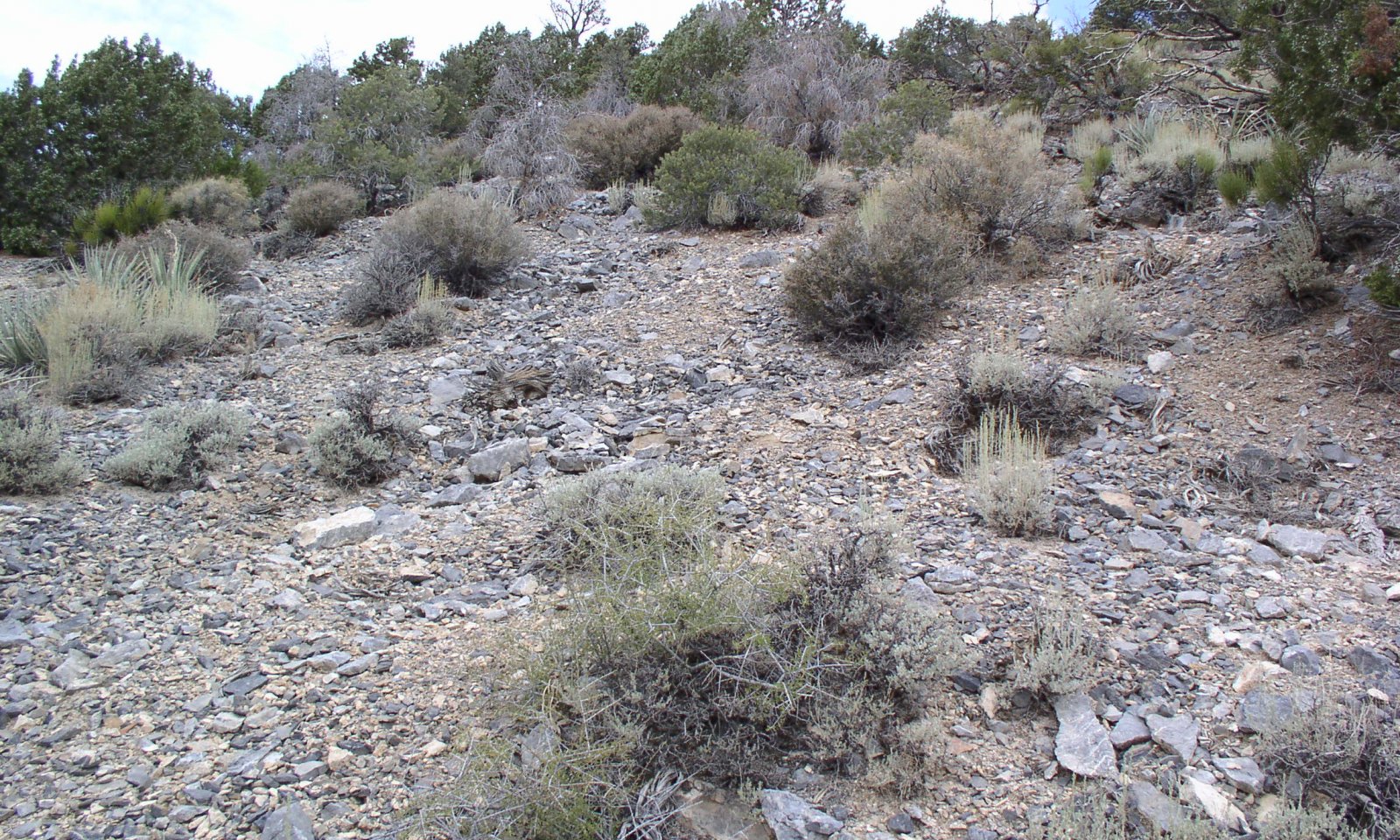
This site occurs on mountain backslopes. Slopes range from 30 to 50 percent. Elevation ranges from 4700 to 7600 feet. The soils associated with this site are shallow, well drained soils that formed in residuum and colluvium from limestone and dolomitic limestone.
Please refer to group concept R030XC040NV to view the provisional STM.Associated sites
F030XC246NV Pinus monophylla-Juniperus osteosperma/Purshia stansburiana-Artemisia tridentata ssp. vaseyana/Poa fendleriana
Forest site at higher elevations on mountain backslopes.
R030XA007NV GRAVELLY LOAM 5-7 P.Z.
Blackbrush site at lower elevations on fans.
Similar sites
F030XC246NV Pinus monophylla-Juniperus osteosperma/Purshia stansburiana-Artemisia tridentata ssp. vaseyana/Poa fendleriana
Forest site at higher elevations on mountain back slopes.
Table 1. Dominant plant species
Tree Not specified
Shrub (1) Artemisia tridentata ssp. vaseyana
Herbaceous (1) Achnatherum speciosum
Physiographic features
This site occurs on mountain backslopes. Slopes range from 30 to 50 percent. Elevation ranges from 4700 to 7600 feet.
Table 2. Representative physiographic features
Landforms (1) Mountain slope
Elevation 4700 – 7600 ft Slope 30 – 50 % Aspect Aspect is not a significant factor Climatic features
The primary air masses affecting the Spring Mountains are cold maritime polar air from the Gulf of Alaska and warmer, moist maritime subtropical air from lower latitudes. Occasionally there are invasions of cold continental polar air from northern Canada or the Rocky Mountains. Precipitation in the area results primarily from the passage of cyclones with associated fronts during fall, winter and spring; from closed cyclones in late winter and spring; and from the flow of moist tropical air from the southeast to the southwest quadrant in the summer.
The mean annual precipitation is about 11 to 13 inches and mean annual air temperature is 51 to 56 degrees F., and the frost-free season is 130 to 180 days.
Table 3 Representative climatic features
Frost-free period (average) 180 days Freeze-free period (average) Precipitation total (average) 10 in ">Influencing water features
There are no influencing water features associated with this site.
Soil features
The soils associated with this site are shallow, well drained soils that formed in residuum and colluvium from limestone and dolomitic limestone. Surface soils are medium to coarse textured. Runoff is very high, and potential for gully, sheet or rill erosion varies with slopes. Water holding capacity is very low. The soils are dry most of the year but are moist for short periods during the winter and early spring months and occasionally for short intermittent period following summer convection storms. The soils have an aridic soil moisture regime bordering on ustic. Soil series associated with this site include Scrapy.
Table 4. Representative soil features
Surface texture (1) Very gravelly sandy loam
(2) Extremely gravelly sandy loam
Family particle size (1) Loamy
Drainage class Well drained Permeability class Moderately rapid Soil depth 10 – 14 in Surface fragment cover <=3" 45 – 60 % Surface fragment cover >3" 5 – 15 % Available water capacity
(0-40in)0.7 – 0.9 in Calcium carbonate equivalent
(0-40in)25 – 35 % Electrical conductivity
(0-40in)0 – 2 mmhos/cm Sodium adsorption ratio
(0-40in)0 – 5 Soil reaction (1:1 water)
(0-40in)7.9 – 9 Subsurface fragment volume <=3"
(Depth not specified)50 – 60 % Subsurface fragment volume >3"
(Depth not specified)0 – 1 % Ecological dynamics
Please refer to group concept R030XC040NV to view the provisional STM.
Where fire occurs due to fuel build up, fire will remove the trees and shrubs. Shrubs that will reestablish include mountain big sagebrush and Stansbury's cliffrose. Where management results in abusive grazing use by livestock and/or feral horses, cool-season perennial grasses decrease as moutain big sagebrush becomes more dominant.
Fire Ecology:
Presettlement fire return intervals in mountain big sagebrush communities varied from 15 to 25 years. Mountain big sagebrush is highly susceptible to injury from fire. It is often top-killed by fire and will not resprout. Blackbrush stands are considered to be one of the most flammable native plant assemblages in the Mojave Desert and fire will start and spread easily due to the dense, close spacing nature and resinous foliage of blackbrush. Blackbrush is slow to reestablish and may take 60 or more years to reestablish. Fire effects on Stansbury cliffrose are variable. Fire may kill or severely damage plants. Late-season fire also increases the risk of mortality. Stansbury cliffrose is a weak sprouter that is generally killed by severe fire. Mormon tea generally sprouts vigorously from the roots or woody root crown after fire and rapidly produces aboveground biomass from surviving meristematic tissue. Desert needlegrass has persistent dead leaf bases, which make it susceptible to burning. Fire removes the accumulation; a rapid, cool fire will not burn deep into the root crown. Most perennial grasses have root crowns that can survive wildfire.State and transition model
More interactive model formats are also available. View Interactive Models
Click on state and transition labels to scroll to the respective textEcosystem states
State 1 submodel, plant communities
State 1
Reference Plant CommunityCommunity 1.1
Reference Plant Community
The reference plant community is dominated by mountain big sagebrush and Stansbury's cliffrose. Blackbrush, Mormon tea, and desert needlegrass are important species associated with this site. Potential vegetative composition is about 20% grasses, 5% forbs and 70% shrubs and up to 5% trees. Approximate ground cover (basal and crown) is about 15 to 25 percent. Total annual air-dry production is 700 pounds favorable years, 500 pounds normal years, and 300 pounds on unfavorable years.
Figure 1. Annual production by plant type (representative values) or group (midpoint values)
Table 5. Annual production by plant type
Plant type Low
(lb/acre)Representative value
(lb/acre)High
(lb/acre)Shrub/Vine 210 350 490 Grass/Grasslike 60 100 140 Tree 15 25 35 Forb 15 25 35 Total 300 500 700 Table 6. Ground cover
Tree foliar cover 0-10% Shrub/vine/liana foliar cover 10-20% Grass/grasslike foliar cover 10-10% Forb foliar cover 0-10% Non-vascular plants 0% Biological crusts 0% Litter 10-10% Surface fragments >0.25" and <=3" 40-60% Surface fragments >3" 10-20% Bedrock 0% Water 0% Bare ground 10-30% Table 7. Canopy structure (% cover)
Height Above Ground (ft) Tree Shrub/Vine Grass/
GrasslikeForb <0.5 1-2% 1-5% 1-5% 1-2% >0.5 <= 1 1-5% 5-10% 5-10% 1-5% >1 <= 2 1-5% 20-20% – – >2 <= 4.5 1-5% 1-5% – – >4.5 <= 13 5-10% – – – >13 <= 40 – – – – >40 <= 80 – – – – >80 <= 120 – – – – >120 – – – – Additional community tables
Table 8. Community 1.1 plant community composition
Group Common name Symbol Scientific name Annual production () Foliar cover (%) Grass/Grasslike1 Primary Perennial Grasses 50–100 desert needlegrass ACSP12 Achnatherum speciosum 50–100 – 2 Secondary Perennial Grasses 5–25 Indian ricegrass ACHY Achnatherum hymenoides 5–15 – squirreltail ELEL5 Elymus elymoides 5–15 – Forb3 Perennial Forbs 15–25 blue grama BOGR2 Bouteloua gracilis 5–10 – sandwort ARENA Arenaria 3–10 – milkvetch ASTRA Astragalus 3–10 – Indian paintbrush CASTI2 Castilleja 3–10 – desert larkspur DEPA Delphinium parishii 3–10 – flax LINUM Linum 3–10 – Fremont's phacelia PHFR2 Phacelia fremontii 3–10 – twinpod PHYSA2 Physaria 3–10 – desert globemallow SPAM2 Sphaeralcea ambigua 3–10 – desert princesplume STPI Stanleya pinnata 3–10 – foothill deathcamas ZIPA2 Zigadenus paniculatus 3–10 – 4 Annual Forbs 1–10 cryptantha CRYPT Cryptantha 3–10 – Shrub/Vine5 Primary Shrubs 215–400 mountain big sagebrush ARTRV Artemisia tridentata ssp. vaseyana 150–200 – blackbrush CORA Coleogyne ramosissima 25–75 – Stansbury cliffrose PUST Purshia stansburiana 25–75 – mormon tea EPVI Ephedra viridis 15–50 – 6 Secondary Shrubs 25–50 black sagebrush ARNO4 Artemisia nova 5–10 – hedgehog cactus ECHIN3 Echinocereus 5–10 – spiny greasebush GLSPA Glossopetalon spinescens var. aridum 5–10 – tulip pricklypear OPPH Opuntia phaeacantha 5–10 – desert almond PRFA Prunus fasciculata 5–10 – banana yucca YUBA Yucca baccata 5–10 – Tree7 Trees 15–35 Utah juniper JUOS Juniperus osteosperma 10–20 – singleleaf pinyon PIMO Pinus monophylla 5–15 – Interpretations
Animal community
Livestock Interpretations:
This site has limited value for livestock grazing, due to the low forage production. Grazing management should be keyed to perennial grasses or palatable shrubs production. Mountain big sagebrush is eaten by domestic livestock but has long been considered to be of low palatability, and a competitor to more desirable species. Blackbrush is not preferred as forage by domestic livestock, but does provide some forage during the spring, summer and fall. Stansbury cliffrose is an important browse species for livestock, especially in the winter. Mormon Tea is heavily browsed by livestock on winter range but only moderately or lightly browsed during other seasons. Young desert needlegrass is palatable to all classes of livestock. Mature herbage is moderately grazed by horses and cattle, but rarely grazed by sheep.
Stocking rates vary over time depending upon season of use, climate variations, site, and previous and current management goals. A safe starting stocking rate is an estimated stocking rate that is fine tuned by the client by adaptive management through the year and from year to year.
Wildlife Interpretations:
Mountain big sagebrush is highly preferred and nutritious winter forage for mule deer and elk. Blackbrush is a valuable browse species for bighorn sheep. It may also comprise up to 25% of the mule deer winter diet. Blackbrush provides cover for upland game birds, nongame birds and small mammals. Stansbury cliffrose is an important browse species for mule deer, pronghorn, game birds, and songbirds. Wild ungulates use it heavily in winter. Mormon tea is an important browse species for big game animals. Mormon tea is heavily used by wildlife on winter ranges. Young desert needlegrass is palatable to many species of wildlife. Desert needlegrass produces considerable basal foliage and is good forage while young. Desert bighorn sheep graze desert needlegrass.
Sagebrush-grassland communities provide critical sage-grouse breeding and nesting habitats. Meadows surrounded by sagebrush may be used as feeding and strutting grounds. Sagebrush is a crucial component of their diet year-round, and sage-grouse select sagebrush almost exclusively for cover. Sage-grouse prefer mountain big sagebrush and Wyoming big sagebrush communities to basin big sagebrush communities.Hydrological functions
Rills – Rills can occur on this site, especially following summer convective storms due to very shallow, skeletal, loamy soils with low water holding capacity and steep slopes. Rills are more likely to appear on steeper slopes.
Water flow Patterns – Found in interspaces between shrubs, connected on steeper slopes. Should be limited except following intense summer storms.
Pedestals and/or Terracettes – Few to none. High gravel cover limits pedestal development. Some terracettes found on steeper slopes.
Gullies – Not uncommon on steep slopes.
Perennial herbaceous plants slow runoff and increase infiltration. Shrub and tree canopy and associated litter break raindrop impact and provide opportunity for snow catch and accumulation on site.Recreational uses
This site is used for camping, hiking and hunting.
Other products
Indian ricegrass was traditionally eaten by some Native American peoples. The Paiutes used seed as a reserve food source.
Other information
Blackbrush contributes to desert fertility by 1) protecting the soil against wind erosion through retarding the movement of soil and increasing the accumulation of fine soil particles around its base; 2) protecting understory vegetation from the effects of high temperatures, thereby helping to retain surface nitrogen and adding organic matter to the soil; and 3) serving as a nitrogen reservoir through the storage of nitrogen in roots, leaves, and stems.
Desert needlegrass seeds are easily germinated and have potential for commercial use. Desert needlegrass may be used for groundcover in areas of light disturbance, but it is susceptible to excessive trampling.
Indian ricegrass is well-suited for surface erosion control and desert revegetation although it is not highly effective in controlling sand movement.Supporting information
Type locality
Location 1: Clark County, NV Township/Range/Section T19 S. R55 E. S7 NE UTM zone N UTM northing 4019988n UTM easting 0604382e General legal description Approximately 2.5 miles north of the junction of Wheeler Wash Road and the Wallace Canyon turn off, Clark County, Nevada. Other references
Clokey, Ira. 1951. Flora of the Charleston Mountains, Clark County, Nevada. University of California Press, Berkeley and Los Angeles.
Fire Effects Information System [Online]. http://www.fs.fed.us/feis.
Glenne, G., Johnson, D. 2002. Guide to Species of Concern in the Spring Mountains National Recreation Area, Clark and Nye Counties, Nevada. USFS, Las Vegas, NV.
Nachlinger, J., G. Reese. 1996. Plant Community Classification of the Spring Mountains National Recreation Area, Clark and Nye Counties, Nevada. The Nature Conservancy. Reno, Nevada.
Contributors
TJW
Approval
Sarah Quistberg, 2/25/2025
Rangeland health reference sheet
Interpreting Indicators of Rangeland Health is a qualitative assessment protocol used to determine ecosystem condition based on benchmark characteristics described in the Reference Sheet. A suite of 17 (or more) indicators are typically considered in an assessment. The ecological site(s) representative of an assessment location must be known prior to applying the protocol and must be verified based on soils and climate. Current plant community cannot be used to identify the ecological site.
Author(s)/participant(s) TJ WOLFE Contact for lead author State Rangeland Management Specialist Date 06/22/2006 Approved by Approval date Composition (Indicators 10 and 12) based on Annual Production Indicators
-
Number and extent of rills:
Rills can occur on this site, especially following summer convective storms due to very shallow, skeletal, loamy soils with low water holding capacity and steep slopes. Rills are more likely to appear on steeper slopes. -
Presence of water flow patterns:
Found in interspaces between shrubs, connected on steeper slopes. Should be limited except following intense summer storms. -
Number and height of erosional pedestals or terracettes:
Few to none. High gravel cover limits pedestal development. Some terracettes found on steeper slopes. -
Bare ground from Ecological Site Description or other studies (rock, litter, lichen, moss, plant canopy are not bare ground):
10 to 25 percent -
Number of gullies and erosion associated with gullies:
Not uncommon on steep slopes. -
Extent of wind scoured, blowouts and/or depositional areas:
No wind-scoured or blow out areas due to high gravel cover. Small depositional areas found up slope of grasses and large shrubs. -
Amount of litter movement (describe size and distance expected to travel):
Litter expected to move the distance of slope length during intense summer convection storms. -
Soil surface (top few mm) resistance to erosion (stability values are averages - most sites will show a range of values):
Soil surface resistance due to high amounts of gravels and vegetative cover and litter. Stability values be 3-5 (not tested). -
Soil surface structure and SOM content (include type of structure and A-horizon color and thickness):
Soils have low organic matter. “A” horizon averages 1 to 3 inch depth. -
Effect of community phase composition (relative proportion of different functional groups) and spatial distribution on infiltration and runoff:
Perennial herbaceous plants slow runoff and increase infiltration. Shrub and tree canopy and associated litter break raindrop impact and provide opportunity for snow catch and accumulation on site. -
Presence and thickness of compaction layer (usually none; describe soil profile features which may be mistaken for compaction on this site):
None -
Functional/Structural Groups (list in order of descending dominance by above-ground annual-production or live foliar cover using symbols: >>, >, = to indicate much greater than, greater than, and equal to):
Dominant:
Sub-dominant:
Other:
Additional:
-
Amount of plant mortality and decadence (include which functional groups are expected to show mortality or decadence):
-
Average percent litter cover (%) and depth ( in):
-
Expected annual annual-production (this is TOTAL above-ground annual-production, not just forage annual-production):
-
Potential invasive (including noxious) species (native and non-native). List species which BOTH characterize degraded states and have the potential to become a dominant or co-dominant species on the ecological site if their future establishment and growth is not actively controlled by management interventions. Species that become dominant for only one to several years (e.g., short-term response to drought or wildfire) are not invasive plants. Note that unlike other indicators, we are describing what is NOT expected in the reference state for the ecological site:
-
Perennial plant reproductive capability:
Print Options
Sections
Font
AAAAOther
PrintThe Ecosystem Dynamics Interpretive Tool is an information system framework developed by the USDA-ARS Jornada Experimental Range, USDA Natural Resources Conservation Service, and New Mexico State University.
Accessibility statement


