Natural Resources
Conservation Service
Ecological site R030XB228CA
Warm Shallow Pediments
Last updated: 10/21/2024
Accessed: 08/18/2026
-
Search
Major Land Resource Area or ecological site by name and/or ID.
PreviousSectionsNextGeneral information
Provisional. A provisional ecological site description has undergone quality control and quality assurance review. It contains a working state and transition model and enough information to identify the ecological site.
Click to explore map
Figure 1. Mapped extent
Areas shown in blue indicate the maximum mapped extent of this ecological site. Other ecological sites likely occur within the highlighted areas. It is also possible for this ecological site to occur outside of highlighted areas if detailed soil survey has not been completed or recently updated.
MLRA notes
Major Land Resource Area (MLRA): 030X–Mojave Basin and Range
MLRA Description:
Major Land Resource Area (MLRA) 30, Mojave Desert, is found in southern California, southern Nevada, the extreme southwest corner of Utah and northwestern Arizona within the Basin and Range Province of the Intermontane Plateaus. The climate of the area is hot (primarily hyperthermic and thermic; however at higher elevations, generally above 5000 feet, mesic, cryic and frigid) and dry (aridic). Elevations range from below sea level to over 12,000 feet in the higher mountain areas found within the MLRA. Due to the extreme elevational range found within this MLRA, Land Resource Units (LRUs) were designated to group the MLRA into similar land units.
LRU Description:
This LRU (designated by ’XB’) is found across the eastern half of California, much of the mid-elevations of Nevada, the southernmost portions of western Utah, and the mid-elevations of northwestern Arizona. Elevations range from 1800 to 5000 feet and precipitation ranges from 4 to 9 inches per year, but is generally between 5-6 inches. This LRU is characterized primarily by the summer precipitation it receives, ranging from 18 – 35% but averages 25%. Summer precipitation falls between July and September in the form of rain, and winter precipitation falls starting in November and ends between February and March, also mostly in the form of rain; however it does receive between 0 and 3 inches of snow, with an average of 1 inch. The soil temperature regime is thermic and the soil moisture regime is typic-aridic. Vegetation includes creosote bush, burrobush, Nevada jointfir, ratany, Mojave yucca, Joshua tree, chollas, cactus, big galleta grass and several other warm season grasses. At the upper portions of the LRU, plant production and diversity are greater and blackbrush is a common dominant shrub.
Ecological Site Concept -
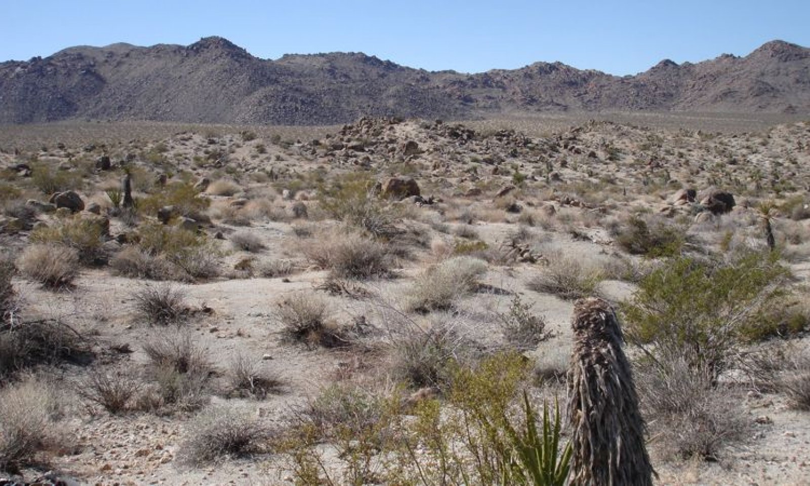
This ecological site occurs on pediments located relatively far from receding mountain fronts, and thus subject to relatively low rates of erosion, at elevations of 2310 to 3330 feet. It occurs on warm thermic, very shallow to shallow soils.
Production Reference Value (RV) is 195 pounds per acre and ranges from 90 to 305 pounds per acre. The site is dominated by creosote bush (Larrea tridentata) and burrobush (Ambrosia dumosa). Relative to surrounding fan aprons, a high diversity of secondary shrubs is present. A warm thermic environment and relatively low levels of erosion supports dominance by creosote bush and burrobush. Low soil moisture holding capacity in shallow soils reduces productivity relative to surrounding fan aprons. Localized run-off from dissected topography provides microsites for a greater diversity of species than is found on surrounding fan aprons.
Data in the following sections is from all components (major and minor) that are correlated with this ecological site.
This site is part of group concept R030XA030CAClassification relationships
Larrea tridentata Shrubland Alliance (Sawyer et al. 2009).
Associated sites
R030XB005NV Arid Active Alluvial Fans
This ecological site occurs on adjacent fan aprons. Creosote bush (Larrea tridentata) and burrobush (Ambrosia dumosa) dominate.
R030XB140CA Shallow Hill 4-6" P.Z.
This ecological site occurs on adjacent hillslopes. Burrobush (Ambrosia dumosa) is dominant.
R030XB225CA Warm Sloping Pediments
This ecological site occurs on adjacent pediments. Hall's shrubby spurge (Tetracoccus hallii) and burrobush (Ambrosia dumosa) dominate.
R030XD003CA Hyperthermic Steep South Slopes
This ecological site occurs on south-facing adjacent mountain slopes. Brittlebush (Encelia farinosa) is dominant.
Similar sites
R030XB221CA Loamy Fan Remnants And Pediments
This ecological site occurs on pediments and fan remnants with moderately deep soils to a duripan. It is dominated by blackbrush (Coleogyne ramosissima), burrobush (Ambrosia dumosa) and Hall’s shrubby spurge (Tetracoccus hallii).
R030XB225CA Warm Sloping Pediments
This ecological site occurs on pediments located closer to the mountain front, where erosion rates are greater, and the landscape is more dissected. This site is co-dominated by Hall’s shrubby spurge (Tetracoccus hallii) and burrobush (Ambrosia dumosa). Creosote bush (Larrea tridentata) is a secondary species.
Table 1. Dominant plant species
Tree Not specified
Shrub (1) Larrea tridentata
(2) Ambrosia dumosaHerbaceous (1) Malacothrix glabrata
Physiographic features
This ecological site occurs on pediments that are relatively far from mountain fronts at elevations of 2310 to 3330 feet. Slopes may range from 2 to 50 percent, but slopes below 15 percent are typical. Runoff class is very low to very high.
Table 2. Representative physiographic features
Landforms (1) Pediment
Flooding frequency None Ponding frequency None Elevation 2310 – 3330 ft Slope 2 – 50 % Aspect Aspect is not a significant factor Climatic features
The climate on this site is characterized by cool, somewhat moist winters and hot, somewhat moist summers, with approximately 60 percent of precipitation falling as rain between November and March, and approximately 30 percent falling as rain between July and October (slightly higher than the average for the XB LRU). Summer precipitation falls as heavy monsoonal events, while winter precipitation is spread out over a longer time period. The average annual precipitation ranges from 4 to 7 inches. Mean annual air temperature is 63 to 68 degrees F, and the frost free period ranges from 270 to 320 days per year.
Maximum and minimum monthly climate data for this ESD were generated by the Climate Summarizer
(http://www.nm.nrcs.usda.gov/technical/handbooks/nrph/Climate_Summarizer.xls) using data
from the following climate stations:
44405 Joshua Tree, California (Period of record = 1959 to 2011) [1]
LTHC1 Lost Horse, Joshua Tree National Park (Period of record = 1991 to 2011) [1]
49099, Twentynine Palms, California (Period of record = 1935 – 2011) [1]
The data from multiple weather were combined to most accurately reflect the climatic conditions of this ecological site. The Lost Horse and Joshua Tree weather stations have colder temperatures and less summer precipitation than this ecological site. The Twentynine Palms weather station has hotter temperatures and less total precipitation than this ecological site.
Table 3 Representative climatic features
Frost-free period (average) 320 days Freeze-free period (average) Precipitation total (average) 10 in BarLineFigure 2. Monthly precipitation range
BarLineFigure 3. Monthly average minimum and maximum temperature
">Influencing water features
Soil features
The dominant soils associated with this ecological site are very shallow to shallow, and formed in residuum derived from granitoid. Surface textures are loamy fine sand and sand, with sandy loam and sand subsurface textures over granitic bedrock. Gravel sized rock fragments (less than 3 inches in diameter), on the surface range from 55 to 80 percent, and larger fragments range from 0 to 25 percent. Subsurface volume of gravel-sized fragments are approximately 10 percent(subsurface fragments by volume for a depth of 0 to 59 inches), and larger fragments range from 0 to 15 percent. These soils are well to somewhat excessively drained with slow to rapid permeability.
The associated soil series that are 15 percent or greater of any one map unit are: Grubstake (loamy, mixed, superactive, thermic, shallow Typic Haplocambids); and Stranger (mixed, thermic Lithic Torripsamments). Other soils on which this site is found are typically 5 percent or less of any map unit when associated with this site. They are: Grinder (loamy, mixed, superactive, thermic Lithic Haplargids); Ironped (mixed, thermic, shallow Typic Torripsamments); and Lostpalms (sandy-skeletal, mixed, thermic Lithic Torriorthents).
These soils occur on hills and pediments. The Grubstake soils are shallow to weathered bedrock which is found on top of unfractured granitoid bedrock. These soils have a cambic horizon above the weathered bedrock with a sandy loam texture. The Stranger soils are very shallow over unfractured granitoid bedrock and are sandy throughout. The Grinder soils are very shallow over unweathered, slightly fractured granitic bedrock, and have an argillic horizon. The Ironped soils are very shallow over weathered granitoid bedrock and are sandy throughout. The Lostpalms soils are sandy-skeletal, and are very shallow over unfractured granitioid bedrock.
This ecological site is correlated with the following map units and soil components in the Joshua Tree National Park Soil Survey:
4825; Rock outcrop-Grubstake-Cajon-Stranger association, 2 to 15 percent slopes; Grubstake; 20; Stranger; warm; 15; Lostpalms; 5; Ironped; 5; Grinder; warm; 5
3110; Coppermine-Stranger complex, 8 to 50 percent slopes; Grubstake; 5
Table 4. Representative soil features
Parent material (1) Residuum – granite
(2) Colluvium – granite
Surface texture (1) Loamy fine sand
(2) Sand
(3) Gravelly sand
Family particle size (1) Loamy
Drainage class Well drained to somewhat excessively drained Permeability class Slow to rapid Soil depth 3 – 20 in Surface fragment cover <=3" 55 – 80 % Surface fragment cover >3" 0 – 25 % Available water capacity
(0-40in)0.4 – 2 in Calcium carbonate equivalent
(0-40in)0 – 1 % Electrical conductivity
(0-40in)0 – 2 mmhos/cm Sodium adsorption ratio
(0-40in)0 – 4 Soil reaction (1:1 water)
(0-40in)6.6 – 8.4 Subsurface fragment volume <=3"
(Depth not specified)10 % Subsurface fragment volume >3"
(Depth not specified)0 – 15 % Ecological dynamics
Abiotic Factors
The abiotic factors affecting this site are a pediment landscape, and warm thermic, shallow soils. This ecological site occurs on pediments located relatively far from receding mountain fronts, at elevations of 2310 to 3330 feet. It occurs on warm thermic, very shallow to shallow soils. The reference plant community is dominated by creosote bush and burrobush and relative to surrounding fan aprons, a diverse secondary shrub community is present.
Pediments are gently sloping, bedrock erosional surfaces of low relief that form at the base of receding mountain fronts. Pediment surfaces are covered by a discontinuous layer of alluvium that is typically thinner closer to the mountain front and eventually thick enough that the pediment is no longer distinct from the alluvial fan (Dohrenwend and Parsons 2009). Closer to the mountain front, erosion is active, and exposed bedrock is dissected and undulating (Dohrenwend and Parsons 2009). Different topographical positions within these dissected pediment landscapes experience different rates of overland flow and rainsplash erosion (Edinger-Marshall and Lund 1999). This ecological site occurs relatively far from the mountain front; thus erosion rates are relatively low, the topography is less sharply dissected, and there is a greater buildup of alluvium than on pediments located close to the mountain front.
Relative to pediments located closer to the mountain front, reduced rates of disturbance, and increased prevalence of areas of deeper soils on this site results in a plant community that resembles the adjacent fan aprons, but that also has characteristics of the harsher pediment environment. Creosote bush and burrobush co-occur over vast areas of North American Deserts, and dominate the fan and hill environments surrounding this site. On this site plants are smaller and less productive due to the shallow soils with low moisture holding capacity relative to adjacent fans.
The dissected pediment landscape, with contrasting and localized areas of soil erosion and deposition, and run-off and run-on, supports a diverse plant community relative to the adjacent more productive and uniform fan aprons. Shallow summits and sideslopes are dominated by the shorter-lived, shallow-rooted, drought-deciduous burrobush while creosote bush and secondary species dominates the lower-lying portions of the sideslopes where there is more run-on from higher positions.
Disturbance dynamics
The major disturbances affecting this ecological site are drought, invasion by non-native species, and erosion.
Drought is an important shaping force in Mojave Desert plant communities (Webb et al. 2003, Hereford et al. 2006). Short-lived perennial shrubs and perennial grasses demonstrate the highest rates of mortality (Webb et al. 2003, Bowers 2005, Hereford et al. 2006, Miriti et al. 2007), and annual species remain dormant in the soil seedbank (Beatley 1969, 1974, 1976). Long-lived shrubs are more likely to exhibit branch-pruning, and or limited recruitment during drought (e.g. Hereford et al. 2006, Miriti et al. 2007), leading to reduced cover and biomass in drought-afflicted communities. Because this ecological site already has sparse cover, further loss of cover due drought-induced mortality increases the susceptibility of this site to increased damages from erosion.
Non-native annual species, including red brome (Bromus rubens), Mediterranean grass (Schismus species), and redstem stork’s bill (Erodium cicutarium), have become naturalized throughout the Mojave Desert over the past century (Rickard and Beatley 1965, D'Antonio and Vitousek 1992, Brooks 1999, Reid et al. 2006, Norton et al. 2007). Although non-native annuals are present in this ecological site, the site is relatively resistant to invasion, since shallow soils and a hot climate reduce available soil moisture, which limits biomass of annuals.
The inability of this site to support a high biomass of annuals, and overall sparse vegetation cover, makes this site relatively resistant to fire, which has increased in other Mojave Desert plant communities due to the continuous fine fuel layer created by non-native annuals in wet years (D'Antonio and Vitousek 1992, Brooks et al. 2004). In the unlikely instance of ignition in this ecological site, fire extent is likely to be small and of low intensity so the effects are insignificant at the landscape scale.
Water erosion is the dominant process modifying and maintaining exposed pediment surfaces (Edinger-Marshall and Lund 1999, Dohrenwend and Parsons 2009), and is an important process modifying and maintaining the vegetation community. Without additional disturbance, the affects of erosion are within the natural range of variability of the reference plant community. However, with additional disturbance (anthropogenic or natural), the effects of erosion may be more severe leading to vegetation and soil loss and potentially a new community phase or state. For example, shrub cover protects the gravelly soils of this ecological site from erosion (Edinger-Marshall and Lund 1999). If shrub cover is reduced due to drought, erosion will remove more soil, which reduces the availability of safe sites for plant establishment, which further reduces shrub cover.State and transition model
Custom diagramStandard diagram
Figure 4. R030XB228CA
More interactive model formats are also available. View Interactive Models
Click on state and transition labels to scroll to the respective textEcosystem states
Land use 2 submodel, ecosystem states
State 2 submodel, plant communities
State 1
Historic StateState 1 represents the historic range of variability for this ecological site. This state no longer exists due to the ubiquitous naturalization of non-native species in the Mojave Desert. Periodic drought and water erosion were the natural disturbances influencing this ecological site.
Data for this State does not exist, but it would have been similar to State 2, except with only native species present. See State 2 narrative for more detailed information.
State 2
Reference StateState 2 represents the current range of variability for this site. Non-native annuals, including red brome, Mediterranean grass, and redstem stork’s bill are naturalized in this plant community. Their abundance varies with precipitation, but they are at least sparsely present (as current year's growth or present in the soil seedbank).
Community 2.1
Reference plant community
Figure 5. Community Phase 2.1
The reference plant community is dominated by creosote bush and burrobush. Secondary species that also co-occur on adjacent fans include Mojave yucca (Yucca schidigera), white ratany (Krameria grayi), and range ratany (Krameria erecta). Secondary species that are more typical of wash habitats that are important on this site include sweetbush, desertsenna, and jojoba. The short-lived, drought-deciduous shrubs Parish’s goldeneye (Viguiera parishii) and Acton’s brittlebush (Encelia actonii), which are common on shallow soils and rocky hills, are also common on this site. The native perennial bunchgrass big galleta occurs in interfluves where additional run-on is available. The native perennial forb, desert trumpet (Eriogonum inflatum) occurs throughout the site. Native winter annuals are seasonally present, though not abundant, and common species include smooth desertdandelion (Malacothrix glabrata), curvenut combseed (Pectocarya recurvata), chia (Salvia columbariae), lupine (Lupinus spp.), and Eriogonum (Eriogonum spp.). Mediterranean grass, red brome and redstem stork’s bill are sparsely present.
Biological soil crusts (BSC) are often associated with grus (granite that is crumbled, but not fully decomposed), which is typical of soil surfaces on this ecological site. These crusts are important for improving soil stability, infiltration, and nutrient cycling on these shallow soils (Belnap et al. 2001). Biological soil crusts form slowly, and are very sensitive to physical disturbance (such as from trampling or off-road vehicle disturbance).Figure 6. Annual production by plant type (representative values) or group (midpoint values)
Table 5. Annual production by plant type
Plant type Low
(lb/acre)Representative value
(lb/acre)High
(lb/acre)Shrub/Vine 90 180 240 Grass/Grasslike 0 10 35 Forb 0 5 30 Total 90 195 305 Community 2.2
Drought responseThis community phase is characterized by an overall decline in cover due to mortality of burrobush and other short-lived species, branch-pruning and lack of recruitment of longer-lived species, including creosote bush, and lack of emergence of annual forbs and grasses.
A long-term monitoring study in the reference plant community found long-periods of stability under average conditions and moderate drought, but high rates of mortality resulting from one year of extreme drought. Following severe drought in 2002, burrobush suffered 68% mortality, virtually no mortality in creosote bush, and short-lived shrubs and subshrubs had up to 100% mortality (Miriti et al. 2007).
This is an at-risk phase, as the increase in bare ground that occurs during drought increases the susceptibility of this site to erosion. Biological soil crusts are dormant during drought, and are especially susceptible to damage by mechanical disturbance when dry (Warren and Eldridge 2003). Thus, any additional disturbance threatens to transition this community phase to a phase of increased erosion, or a new state, where significant loss of ecological function has occurred.
Pathway 2.1a
Community 2.1 to 2.2This pathway occurs with severe or prolonged drought.
Pathway 2.2a
Community 2.2 to 2.1This pathway occurs with time and a return to average or above average precipitation.
State 3
Eroded StateThis state is characterized by severe soil erosion. Biological soil crusts are largely absent, gullying is pronounced, and soil surfaces have no protective surface gravels. Vegetative cover is restricted to interfluves.
Transition 1
State 1 to 2This transition occurred with the naturalization of non-native species in this ecological site. Non-native species were introduced with settlement of the Mojave Desert region in the 1860s.
Transition 2
State 2 to 3This transition occurs with severe or continuous anthropogenic disturbance that increases the effects of erosion.
Additional community tables
Table 6. Community 2.1 plant community composition
Group Common name Symbol Scientific name Annual production () Foliar cover (%) Shrub/Vine1 Native shrubs 90–240 creosote bush LATR2 Larrea tridentata 40–120 5–15 desertsenna SEAR8 Senna armata 5–55 0–3 burrobush AMDU2 Ambrosia dumosa 5–40 5–10 white ratany KRGR Krameria grayi 10–35 2–3 Mojave yucca YUSC2 Yucca schidigera 0–30 0–1 Parish's goldeneye VIPA14 Viguiera parishii 5–25 1–3 sweetbush BEJU Bebbia juncea 5–20 0–3 Acton's brittlebush ENAC Encelia actonii 0–15 0–2 littleleaf ratany KRER Krameria erecta 0–10 0–2 jojoba SICH Simmondsia chinensis 0–5 0–1 Forb2 Native forbs 0–20 smooth desertdandelion MAGL3 Malacothrix glabrata 0–15 0–2 curvenut combseed PERE Pectocarya recurvata 0–1 0–1 chia SACO6 Salvia columbariae 0–1 0–1 desert trumpet ERIN4 Eriogonum inflatum 0–1 0–1 buckwheat ERIOG Eriogonum 0–1 0–1 lupine LUPIN Lupinus 0–1 0–1 4 Non-native annual forbs 0–5 redstem stork's bill ERCI6 Erodium cicutarium 0–5 0–1 Grass/Grasslike3 Native perennial grasses 0–35 big galleta PLRI3 Pleuraphis rigida 0–35 0–2 5 Non-native annual grasses 0–1 red brome BRRU2 Bromus rubens 0–1 0–1 Mediterranean grass SCHIS Schismus 0–1 0–1 Table 7. Community 2.2 plant community composition
Group Common name Symbol Scientific name Annual production () Foliar cover (%) Interpretations
Animal community
This ecological site is habitat for the threatened desert tortoise (Gopherus agassizii agassizii). Creosote bush shrublands provides a home for an abundance of specialist insect species, for example, creosote bush flowers provide nutrition for over twenty species of bees, and the creosote bush grasshopper (Bootettix argentatus) feeds solely on creosote leaves (Pavlik 2008).
Recreational uses
This ecological site can be used for hiking and aesthetic enjoyment. Pediment landscapes are an unusual and interesting feature of arid environments.
Other information
Creosote bush is an important medicinal plant for Native Americans. It has a very wide range of uses from treatment for consumption, bowl complaints, and menstrual cramps, to induce vomiting, relief for arthritis, rheumatism, aching bones and sprains, congestion and cold, as an antiseptic and disinfectant, dandruff, antispasmodic, to induce urination, gonorrhea, and to cancer treatment. (This list is not exhaustive). http://herb.umd.umich.edu/herb/search.pl?searchstring=Larrea+tridentata.
Creosote bush stems are used to make weapons, digging tools, and basket handles, and creosote gum is used for knife and awl handles. Creosote bush branches are used as thatch in dwelling construction. http://herb.umd.umich.edu/herb/search.pl?searchstring=Larrea+tridentata.
Supporting information
Inventory data references
The following NRCS vegetation plots were used to describe this ecological site: Community Phase 2.1: POWA28 (Type location) POWA30 POWA38
Type locality
Location 1: Riverside County, CA UTM zone N UTM northing 3740672 UTM easting 615491 General legal description The type location is approximately 1.7 miles east southeast (91 degrees) from the Pinto Basin Road, Smoketree Wash Wayside Exhibit, in Joshua Tree National Park. Other references
Beatley, J. C. 1969. Dependence of desert rodents on winter annuals and precipitation. Ecology 50:721-724.
Beatley, J. C. 1974. Effects of rainfall and temperature on the distribution and behavior of Larrea tridentata (Creosote-bush) in the Mojave Desert of Nevada. Ecology 55:245-261.
Beatley, J. C. 1976. Rainfall and fluctuating plant populations in relation to distributions and numbers of desert rodents in southern Nevada. Oecologia 24:21-42.
Belnap, J., J. H. Kaltenecker, R. Rosentreter, J. Williams, S. Leonard, and D. Eldridge. 2001. Biological soil crusts: ecology and management. Technical Reference 1730-2, United States Department of the Interior Bureau of Land Management, Denver, CO.
Bowers, J. E. 2005. Effects of drought on shrub survival and longevity in the northern Sonoran Desert. Journal of the Torrey Botanical Society 132:421-431.
Brooks, M. L. 1999. Habitat invasibility and dominance by alien annual plants in the western Mojave Desert. Biological Invasions 1:325-337.
Brooks, M. L., C. M. D'Antonio, D. M. Richardson, J. B. Grace, J. E. Keeley, J. M. DiTomaso, R. J. Hobbs, M. Pellant, and D. Pyke. 2004. Effects of invasive alien plants on fire regimes. Bioscience 54:677-689.
D'Antonio, C. M. and P. M. Vitousek. 1992. Biological invasions by exotic grasses, the grass/fire cycle, and global change. Annual Review of Ecology and Systematics 23:63-87.
Dohrenwend, J. C. and A. J. Parsons. 2009. Pediments in arid environments. Pages 375-412 in A. J. Parsons and A. D. Abrahams, editors. Geomorphology of desert environments. Springer.
Dressler, R. L. 1954. Some floristic relationships between Mexico and the United States. Rhodora 56:81-96.
Edinger-Marshall, S. B. and L. J. Lund. 1999. Gravel dispersion on a granite pediment (East Mojave Desert, California): a short-term look at erosional processes. Earth Surface Processes and Landforms 24:349-359.
Guerrero-Campo, J. and G. Montserrat-Marti. 2000. Effects of soil erosion on the floristic composition of plant communities on marl in northeast Spain. Journal of Vegetation Science 11:329-336.
Guerrero-Campo, J., S. Palacio, and G. Montserrat-Marti. 2008. Plant traits enabling survival in Mediterranean badlands in northeastern Spain suffering from soil erosion. Journal of Vegetation Science 19:457-464.
Hereford, R., R. H. Webb, and C. I. Longpre. 2006. Precipitation history and ecosystem response to multidecadal precipitation variability in the Mojave Desert region, 1893-2001. Journal of Arid Environments 67:13-34.
Miriti, M. N., S. Rodriguez-Buritica, S. J. Wright, and H. F. Howe. 2007. Episodic death across species of desert shrubs. Ecology 88:32-36.
Norton, J. B., T. A. Monaco, and U. Norton. 2007. Mediterranean annual grasses in western North America: kids in a candy store. Plant Soil 298:1-5.
Pavlik, B. M. 2008. The California Deserts: an ecological rediscovery. University of California Press, Ltd., Berkeley and Los Angeles, California.
Reid, C. R., S. Goodrich, and J. E. Bowns. 2006. Cheatgrass and red brome: history and biology of two invaders. Pages 27-32 in Shrublands under fire: disturbance and recovery in a changing world. U.S. Department of Agriculture, Forest Service, Rocky Mountain Research Station, Cedar City, Utah.
Rickard, W. H. and J. C. Beatley. 1965. Canopy-coverage of the desert shrub vegetation mosaic of the Nevada test site. Ecology 46:524-529.
Sawyer, J. O., T. Keeler-Woolf, and J. M. Evans. 2009. A manual of California vegetation. 2nd edition. California Native Plant Society, Sacramento, California.
Warren, S. D. and D. J. Eldridge. 2003. Biological soil crusts and livestock in arid ecosystems are they compatible? Pages 401-416 in J. Belnap and O. L. Lange, editors. Biological soil crusts: structure, function, and management. Springer-Verlag, Berlin, Germany.
Webb, R. H., M. B. Muroy, T. C. Esque, D. E. Boyer, L. A. DeFalco, D. F. Haines, D. Oldershaw, S. J. Scoles, K. A. Thomas, J. B. Blainey, and P. A. Medica. 2003. Perennial vegetation data from permanent plots on the Nevada Test Site, Nye County, Nevada. U.S. Geological Society, Tucson, AZ.
Contributors
Alice Lee Miller
Marchel MunneckeApproval
Kendra Moseley, 10/21/2024
Rangeland health reference sheet
Interpreting Indicators of Rangeland Health is a qualitative assessment protocol used to determine ecosystem condition based on benchmark characteristics described in the Reference Sheet. A suite of 17 (or more) indicators are typically considered in an assessment. The ecological site(s) representative of an assessment location must be known prior to applying the protocol and must be verified based on soils and climate. Current plant community cannot be used to identify the ecological site.
Author(s)/participant(s) Contact for lead author Date 08/18/2026 Approved by Approval date Composition (Indicators 10 and 12) based on Annual Production Indicators
-
Number and extent of rills:
-
Presence of water flow patterns:
-
Number and height of erosional pedestals or terracettes:
-
Bare ground from Ecological Site Description or other studies (rock, litter, lichen, moss, plant canopy are not bare ground):
-
Number of gullies and erosion associated with gullies:
-
Extent of wind scoured, blowouts and/or depositional areas:
-
Amount of litter movement (describe size and distance expected to travel):
-
Soil surface (top few mm) resistance to erosion (stability values are averages - most sites will show a range of values):
-
Soil surface structure and SOM content (include type of structure and A-horizon color and thickness):
-
Effect of community phase composition (relative proportion of different functional groups) and spatial distribution on infiltration and runoff:
-
Presence and thickness of compaction layer (usually none; describe soil profile features which may be mistaken for compaction on this site):
-
Functional/Structural Groups (list in order of descending dominance by above-ground annual-production or live foliar cover using symbols: >>, >, = to indicate much greater than, greater than, and equal to):
Dominant:
Sub-dominant:
Other:
Additional:
-
Amount of plant mortality and decadence (include which functional groups are expected to show mortality or decadence):
-
Average percent litter cover (%) and depth ( in):
-
Expected annual annual-production (this is TOTAL above-ground annual-production, not just forage annual-production):
-
Potential invasive (including noxious) species (native and non-native). List species which BOTH characterize degraded states and have the potential to become a dominant or co-dominant species on the ecological site if their future establishment and growth is not actively controlled by management interventions. Species that become dominant for only one to several years (e.g., short-term response to drought or wildfire) are not invasive plants. Note that unlike other indicators, we are describing what is NOT expected in the reference state for the ecological site:
-
Perennial plant reproductive capability:
Print Options
Sections
Font
AAAAOther
PrintThe Ecosystem Dynamics Interpretive Tool is an information system framework developed by the USDA-ARS Jornada Experimental Range, USDA Natural Resources Conservation Service, and New Mexico State University.
Accessibility statement