
Natural Resources
Conservation Service
-
Search


Major Land Resource Area or ecological site by name and/or ID.
PreviousSectionsNextGeneral information
Provisional. A provisional ecological site description has undergone quality control and quality assurance review. It contains a working state and transition model and enough information to identify the ecological site.
Click to explore map
Figure 1. Mapped extent
Areas shown in blue indicate the maximum mapped extent of this ecological site. Other ecological sites likely occur within the highlighted areas. It is also possible for this ecological site to occur outside of highlighted areas if detailed soil survey has not been completed or recently updated.
MLRA notes
Major Land Resource Area (MLRA): 030X–Mojave Basin and Range
MLRA Description:
Major Land Resource Area (MLRA) 30, Mojave Desert, is found in southern California, southern Nevada, the extreme southwest corner of Utah and northwestern Arizona within the Basin and Range Province of the Intermontane Plateaus. The climate of the area is hot (primarily hyperthermic and thermic; however at higher elevations, generally above 5000 feet, mesic, cryic and frigid) and dry (aridic). Elevations range from below sea level to over 12,000 feet in the higher mountain areas found within the MLRA. Due to the extreme elevational range found within this MLRA, Land Resource Units (LRUs) were designated to group the MLRA into similar land units.
LRU Description:
This LRU (designated by ’XB’) is found across the eastern half of California, much of the mid-elevations of Nevada, the southernmost portions of western Utah, and the mid-elevations of northwestern Arizona. Elevations range from 1800 to 5000 feet and precipitation ranges from 4 to 9 inches per year, but is generally between 5-6 inches. This LRU is characterized primarily by the summer precipitation it receives, ranging from 18 – 35% but averages 25%. Summer precipitation falls between July and September in the form of rain, and winter precipitation falls starting in November and ends between February and March, also mostly in the form of rain; however it does receive between 0 and 3 inches of snow, with an average of 1 inch. The soil temperature regime is thermic and the soil moisture regime is typic-aridic. Vegetation includes creosote bush, burrobush, Nevada jointfir, ratany, Mojave yucca, Joshua tree, chollas, cactus, big galleta grass and several other warm season grasses. At the upper portions of the LRU, plant production and diversity are greater and blackbrush is a common dominant shrub.
Ecological Site Concept –
This ecological site is found on eroded fan remnants at elevations of approximately 2200 to 3400 feet. Soils are very shallow to a cemented duripan, and soil surfaces have a high cover of gravel and cobble- sized strongly-cemented durinodes. This site is located close to the MLRA30-31 (Mojave – Colorado Desert) boundary, and has a relatively warm climate with few frost days.
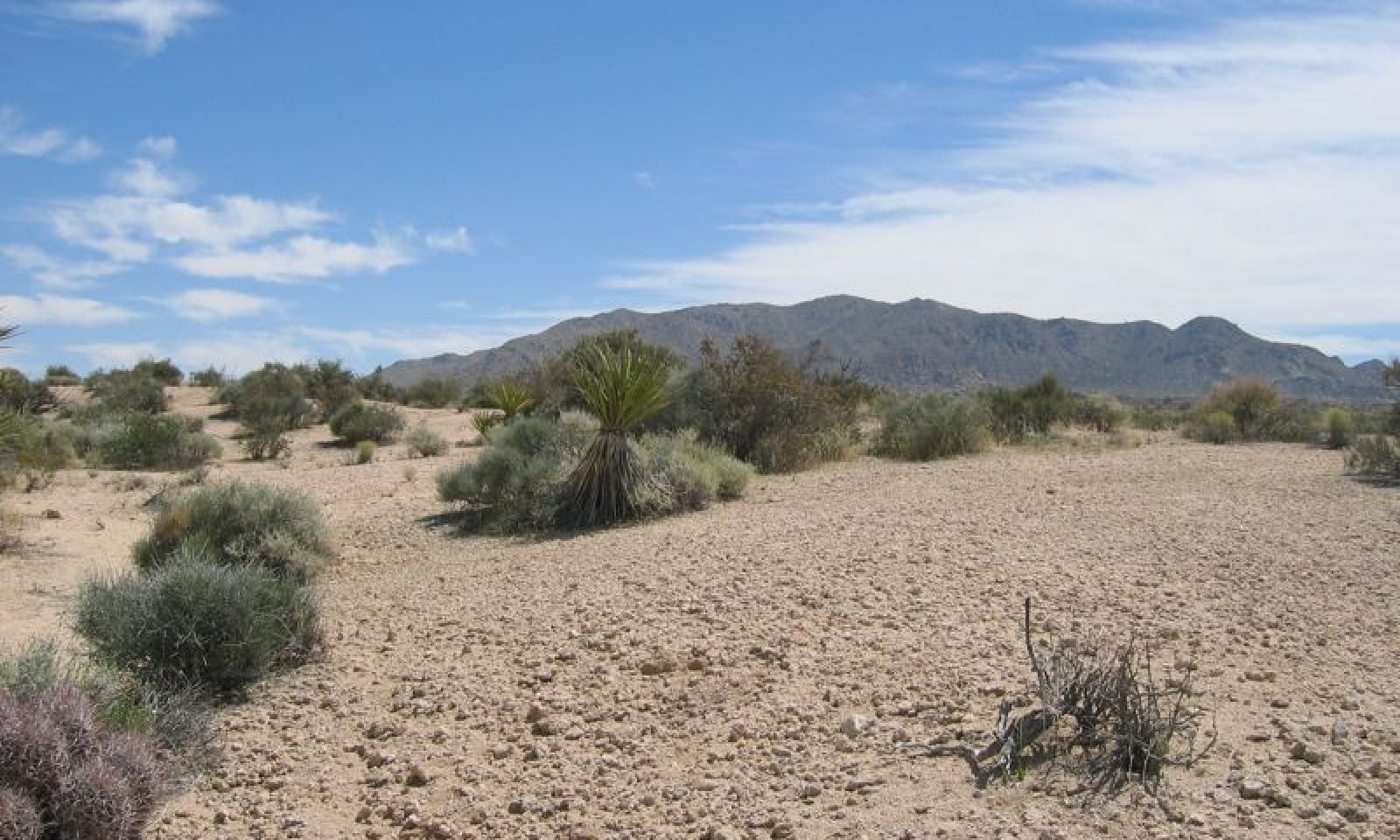
The combination of very shallow soils, a pavement-like durinodic soil surface, and the relatively high summer precipitation and warm climate produces a unique and diverse plant community. Vegetation is sparse and open, with an aggregated distribution. Production is low relative to surrounding landforms, with a reference value (RV) of 250 pounds per acre. The site is dominated by burrobush (Ambrosia dumosa), lotebush (Ziziphus obtusifolia), and Hall’s shrubby spurge (Tetracoccus hallii), and the rare shrub, desert polygala (Polygala acanthoclada) is a distinguishing shrub found on this site. Very shallow soils limit annual forb production, but a high diversity of native annual forbs occurs on this site.
Data in the physiographic and soils sections are based on all components (i.e. major and minor) correlated with this ecological site.
Associated sites
R030XB221CA Loamy Fan Remnants And Pediments
R030XB221CA is found on adjacent moderately deep fan remnants. Blackbrush (Coleogyne ramosissima), burrobush (Ambrosia dumosa) and Hall's shrubby spurge (Tetracoccus hallii) dominate.
R030XB218CA Moderately Deep To Very Deep Loamy Fan Remnants
R030XB218CA is found on adjacent fan aprons over fan remnants. Burrobush (Ambrosia dumosa), Hall's shrubby spurge (Tetracoccus hallii), and creosote bush (Larrea tridentata) are dominant species.
Similar sites
R030XB221CA Loamy Fan Remnants And Pediments
R030XB221CA occurs on pediments and fan remnants with moderately deep soils. Production is higher, and the site is co-dominated by blackbrush (Coleogyne ramosissima), burrobush (Ambrosia dumosa) and Hall's shrubby spurge (Tetracoccus hallii).
R030XB225CA Warm Sloping Pediments
R030XB225CA occurs on pediments and is dominated by burrobush (Ambrosia dumosa) and Hall's shrubby spurge (Tetracoccus hallii).
Table 1. Dominant plant species
Tree Not specified
Shrub (1) Ambrosia dumosa
(2) Ziziphus obtusifoliaHerbaceous Not specified
Physiographic features
This ecological site occurs on eroded fan remnants at elevations of 2230 to 3410 feet. Slopes may range from 2 to 50 percent, but slopes of 2 to 8 percent are typical. The site experiences no flooding or ponding, and runoff class is high to very high.
Table 2. Representative physiographic features
Landforms (1) Fan remnant
Flooding frequency None Ponding frequency None Elevation 2230 – 3410 ft Slope 2 – 50 % Aspect Aspect is not a significant factor Climatic features
The climate on this site is characterized by cool, somewhat moist winters and hot, somewhat moist summers, with approximately 60 percent of precipitation falling as rain between November and March, and approximately 30 percent falling as rain between July and October (slightly higher than the average for the XB LRU). Summer precipitation falls as heavy monsoonal events, while winter precipitation is spread out over a longer time period. The average annual precipitation ranges from 4 to 7 inches. Mean annual air temperature is 63 to 68 degrees F, and the frost free period ranges from 270 to 320 days per year.
Maximum and minimum monthly climate data for this ESD were generated by the Climate Summarizer
(http://www.nm.nrcs.usda.gov/technical/handbooks/nrph/Climate_Summarizer.xls) using data
from the following climate stations:
44405 Joshua Tree, California (Period of record = 1959 to 2011) [1]
LTHC1 Lost Horse, Joshua Tree National Park (Period of record = 1991 to 2011) [1]
49099, Twentynine Palms, California (Period of record = 1935 – 2011) [1]
The data from multiple weather were combined to most accurately reflect the climatic conditions of this ecological site. The Lost Horse and Joshua Tree weather stations have colder temperatures and less summer precipitation than this ecological site. The Twentynine Palms weather station has hotter temperatures and less total precipitation than this ecological site.
Table 3 Representative climatic features
Frost-free period (average) 320 days Freeze-free period (average) 0 days Precipitation total (average) 10 in BarLineFigure 2. Monthly precipitation range
BarLineFigure 3. Monthly average minimum and maximum temperature
">Influencing water features
Soil features
The soils associated with this ecological site formed in alluvium derived from granite and gneiss. There is only one soil associated with this ecological site: Minhoyt soils. Minhoyt soils are loamy, mixed, superactive, thermic, shallow Typic Haplodurids. These soils are very shallow to a duripan. Surface textures are sandy loam with loamy coarse sand and cemented loamy coarse sand beneath. The duripan begins at depths of 1 to 7 inches (Bkq2 horizon), and extends to depths greater than 59 inches. The A and Bkq1 horizons are noncemented, but contain 5 and 8 percent strongly-cemented durinodes. The Bkq2 horizon is moderately to strongly cemented, with few roots that are restricted to cracks; this horizon is considered root limiting, since cracks are greater than 10 cm apart. Surface rock fragments less than 3 inches are about 60 percent cover, and are dominated by gravel-sized strongly cemented durinodes; rock fragments greater than 3 inches are about 6 percent cover. Subsurface rock fragments less than 3 inches range from 3 to 30 percent by volume, and larger rock fragments are absent. These soils are well-drained with moderately rapid permeability.
This ecological site is associated with the following map units and soil component in the Joshua Tree National Park Soil Survey (CA794):
4260;Minhoyt-Corbilt association, 2 to 8 percent slopes;Minhoyt;;45; Minhoyt;sloping;5
Table 4. Representative soil features
Parent material (1) Alluvium – granite
Surface texture (1) Sandy loam
Family particle size (1) Loamy
Drainage class Well drained Permeability class Moderately rapid Soil depth 1 – 7 in Surface fragment cover <=3" 59 – 60 % Surface fragment cover >3" 6 – 10 % Available water capacity
(0-40in)0.1 – 0.2 in Calcium carbonate equivalent
(0-40in)5 – 44 % Electrical conductivity
(0-40in)0 – 2 mmhos/cm Sodium adsorption ratio
(0-40in)0 – 4 Soil reaction (1:1 water)
(0-40in)8 – 8.3 Subsurface fragment volume <=3"
(Depth not specified)3 – 30 % Subsurface fragment volume >3"
(Depth not specified)Not specified Ecological dynamics
This ecological site occurs on eroded fan remnants at elevations of approximately 2200 to 3400 feet. Soils are very shallow to a duripan, and there is a high cover of durinode fragments on the soil surface. This ecological site occurs at the southern edge of the Mojave Desert (the Mojave Desert - Colorado Desert or MLRA30-31 boundary). Thus, it represents a transition from a warm desert where winter precipitation is dominant, to a hot desert where summer precipitation is much more significant. The combination of very shallow soils, pavement-like durinodic soil surface, and the relatively high summer precipitation and warm climate produces a unique and diverse plant community.
Vegetation is sparse and open, with an aggregated distribution. Shrubs are limited to establishment in locations where roots can gain access to cracks in the duripan. Plants are aggregated because an established shrub will alter the soil properties below the shrub canopy and in the rhizospere, creating a zone more hospitable for additional plant establishment in a ‘fertile island’ effect (Muller 1953, Walker et al. 2001, Bolling and Walker 2002). Production is low relative to surrounding landforms, with a reference value of 250 pounds per acre. The site is dominated by burrobush, lotebush, and Hall’s shrubby spurge. The rare shrub, desert polygala is a distinguishing species found on this site. Very shallow soils limit annual forb production, but a high diversity of native annual forbs occurs on this site.
Burrobush is drought-deciduous, shallow-rooted species widespread in the Mojave and Colorado Deserts. Lotebush is deep-rooted large shrub dependent on warm season precipitation for establishment, and is more typical of the Sonoran and Chihuahuan Desert species. Hall's shrubby spurge is a rare plant endemic to southeastern California and Western Arizona. It occurs as a dominant shrub on a range of soils and landforms around Cottonwood Springs and the Eagle Mountains of Joshua Tree National Park, with a more localized distribution in other parts of its range (Dressler 1954). There is little research about the life cycle, drought and fire response of this species. The Cottonwood Springs area is likely a relictual stronghold of a formerly more continuous distribution of Hall’s shrubby spurge, when rainfall across the region was more abundant (Dressler 1954). Desert polygala is rare in California, and more common in the Great Basin Desert where precipitation is higher. The harsh edaphic conditions of this ecological site may increase the competitive ability of desert polygala relative to more productive sites.
Disturbance dynamics
The primary disturbances influencing this ecological site are drought, invasion by non-native annual plants, and erosion.
Drought is an important shaping force in Mojave Desert plant communities (Webb et al. 2003, Bowers 2005, Hereford et al. 2006, Miriti et al. 2007). Short-lived perennial shrubs and perennial grasses demonstrate the highest rates of mortality (Webb et al. 2003, Bowers 2005, Hereford et al. 2006, Miriti et al. 2007), and annual species remain dormant in the soil seedbank (Beatley 1969, 1974, 1976). Long-lived shrubs and trees are more likely to exhibit branch-pruning, and or limited recruitment during drought (e.g. Hereford et al. 2006, Miriti et al. 2007), leading to reduced cover and biomass in drought-afflicted communities.
Non-native annual grasses and forbs, including red brome (Bromus rubens), Mediterranean grass (Schismus species), redstem stork’s bill (Erodium cicutarium), and Asian mustard (Brassica tournefortii), have become naturalized throughout the Mojave Desert over the past century (Rickard and Beatley 1965, D'Antonio and Vitousek 1992, Brooks 1999, Reid et al. 2006, Norton et al. 2007). Annual cover and production is directly related to winter precipitation (Beatley 1969, Brooks and Berry 2006, Hereford et al. 2006), and several years of drought may reduce the abundance of non-native annuals in the soil sandbank (Minnich 2003). Non-native annual cover and biomass is highest on deep sandy soils (Rao et al. 2010), because of the higher availability of water in these soils (Noy-Meir 1973, Austin et al. 2004).
When undisturbed, the high surface rock fragment cover and shallow soils of this ecological site restrict establishment and biomass of non-native species, but where soil surface gravels and durinodes have been disturbed, exposing the underlying sand, Asian mustard may achieve relatively high biomass. Soil disturbance, such as from trampling, construction, or off-road vehicle use not only increases the susceptibility of this site to invasion, but it disrupts the unique soil characteristics that shape the vegetation community of this site.State and transition model
Custom diagramStandard diagram
Figure 4. R030XB220CA
More interactive model formats are also available. View Interactive Models
More interactive model formats are also available. View Interactive Models
Click on state and transition labels to scroll to the respective textEcosystem states
Land use 2 submodel, ecosystem states
State 2 submodel, plant communities
State 1
Historic StateState 1 represents the historic range of variability for this ecological site. This state no longer exists due to the ubiquitous naturalization of non-native species in the Mojave Desert. Periodic drought and rare fire were the natural disturbances influencing this ecological site. Fire would have been a very rare occurrence due to the lack of a continuous fine fuel layer between shrubs (Brown and Minnich 1986, Brooks et al. 2007).
Data for this State does not exist, but dynamics and composition would have been similar to State 2, except with only native species present. See State 2 narrative for more detailed information.
State 2
Reference StateState 2 represents the current range of variability for this site. Non-native annuals, including Mediterranean grass, red brome, Asian mustard and red-stem stork’s bill (Erodium cicutarium) are naturalized in this plant community. Their abundance varies with precipitation, but they are at least sparsely present (as current year’s growth or present in the soil seedbank).
Community 2.1
Reference plant community
Figure 5. Community Phase 2.1

Figure 6. Community Phase 2.1
The reference plant community is characterized by sparse, open shrub cover comprised of a diverse shrub assemblage. Burrobush is weakly dominant with lotebush and Hall’s shrubby spurge. Important secondary shrubs include desert polygala (Polygala acanthoclada), Nevada jointfir (Ephedra nevadensis), Mojave yucca (Yucca schidigera), and waterjacket (Lycium andersonii). Creosote bush (Larrea tridentata) may be present, but tends to occupy positions with greater run-on, such as the base of remnant slopes. Blackbrush (Coleogyne ramosissima) may be sparsely present. A very diverse assemblage of native annual forbs is present with adequate winter precipitation, but biomass of annual species is low, and is largely restricted to under the canopy of shrubs. The non-native forbs redstem stork’s bill (Erodium cicutarium) and Asian mustard (Brassica tournefortii) are naturalized in this plant community, as are the non-native annual grasses red brome and Mediterranean grass.
Asian mustard poses a threat to this plant community. This species is abundant on deeper sands in surrounding landscapes, and is already present at higher densities and biomass loads than native annual forbs, and may displace native annuals or shrub seedlings from limited microsites available for establishment. Although the shallow soils of this ecological site are not ideal habitat for Asian mustard, it appears to readily establish and reach higher biomass in locations where soil surface gravels and durinodes have been disturbed. Disturbance of surface gravels and durinodes facilitates seedling establishment by giving roots access to the shallow non or weakly cemented soil horizons (A, Bkq, Bkq1), and may increase localized infiltration. Seed production is directly related to plant size in this plant, so these larger plants may especially overwhelm native seed banks. Soil disturbance should be minimized in this ecological site, and disturbed areas must be monitored for Asian mustard.Figure 7. Annual production by plant type (representative values) or group (midpoint values)
Table 5. Annual production by plant type
Plant type Low
(lb/acre)Representative value
(lb/acre)High
(lb/acre)Shrub/Vine 130 190 260 Forb 2 50 90 Grass/Grasslike 0 0 8 Total 132 240 358 Community 2.2
Drought responseThis community phase is characterized by an overall decline in cover due to mortality of burrobush and Hall’s shrubby spurge, branch-pruning and lack of recruitment of longer-lived species including lotebush, and lack of emergence of annual forbs and grasses.
A long-term monitoring study in the reference plant community found long-periods of stability under average conditions and moderate drought, but high rates of mortality resulting from one year of extreme drought. Following severe drought in 2002, burrobush suffered 68% mortality, Hall’s shrubby spurge 58%, short-lived shrubs and subshrubs up to 100% mortality (Miriti et al. 2007).
This is an at-risk phase, as the increase in bare ground that occurs during drought increases the susceptibility of this site to erosion and disturbance of shallow surface soils. Thus, any additional disturbance threatens to transition this community phase to an altered state.Pathway 2.1a
Community 2.1 to 2.2This pathway occurs with prolonged or severe drought.
Pathway 2.2a
Community 2.2 to 2.1This pathway occurs with time and a return to average or above average precipitation.
State 3
Eroded StateThis state has been significantly altered from the natural range of variability found in States 1 and 2. Initially soil disturbance increases the susceptibility of this site to invasion by Asian mustard, redstem stork’s bill, Mediterranean grass, and red brome. With further disturbance and drought, this state could experience severe soil erosion. With a lack of protective surface fragments, erosion may remove very shallow, noncemented soil horizons, and vegetative cover may be restricted to depressions and remnant margins.
We do not have data for this state.
Transition 1
State 1 to 2This transition occurred with the naturalization of non-native species in this ecological site. Non-native species were introduced with settlement of the Mojave Desert region in the 1860s.
Transition 2
State 2 to 3This transition occurs with significant soil disturbance to this ecological site, such as from construction activities or off-road vehicle use.
Additional community tables
Table 6. Community 2.1 plant community composition
Group Common name Symbol Scientific name Annual production () Foliar cover (%) Shrub/Vine1 Native shrubs 130–260 Hall's shrubby-spurge TEHA Tetracoccus hallii 5–84 2–4 burrobush AMDU2 Ambrosia dumosa 45–70 1–4 Mojave yucca YUSC2 Yucca schidigera 3–50 1–2 lotebush ZIOB Ziziphus obtusifolia 5–50 1–2 Nevada jointfir EPNE Ephedra nevadensis 15–35 1–3 creosote bush LATR2 Larrea tridentata 0–20 0–2 white ratany KRGR Krameria grayi 0–10 0–1 Mojave woodyaster XYTO2 Xylorhiza tortifolia 0–10 0–1 blackbrush CORA Coleogyne ramosissima 0–10 0–1 water jacket LYAN Lycium andersonii 1–7 0–1 desert polygala POAC2 Polygala acanthoclada 1–5 0–1 branched pencil cholla CYRA9 Cylindropuntia ramosissima 0–3 0–1 Forb2 Native forbs 2–50 curvenut combseed PERE Pectocarya recurvata 0–15 0–1 desert globemallow SPAM2 Sphaeralcea ambigua 0–2 0–1 desert princesplume STPI Stanleya pinnata 0–1 0–1 lacy phacelia PHTA Phacelia tanacetifolia 0–1 0–1 chia SACO6 Salvia columbariae 0–1 0–1 brittle spineflower CHBR Chorizanthe brevicornu 0–1 0–1 pincushion flower CHFR Chaenactis fremontii 0–1 0–1 bearded cryptantha CRBA5 Cryptantha barbigera 0–1 0–1 cryptantha CRYPT Cryptantha 0–1 0–1 flatcrown buckwheat ERDE6 Eriogonum deflexum 0–1 0–1 Moapa bladderpod LETE3 Lesquerella tenella 0–1 0–1 desert calico LOMA10 Loeseliastrum matthewsii 0–1 0–1 smooth desertdandelion MAGL3 Malacothrix glabrata 0–1 0–1 whitestem blazingstar MEAL6 Mentzelia albicaulis 0–1 0–1 Bigelow's monkeyflower MIBI6 Mimulus bigelovii 0–1 0–1 Mojave desertstar MOBE2 Monoptilon bellioides 0–1 0–1 purplemat NADE Nama demissum 0–1 0–1 chuckwalla combseed PEHE Pectocarya heterocarpa 0–1 0–1 broadfruit combseed PEPL Pectocarya platycarpa 0–1 0–1 3 Non-native annual forbs 0–75 Asian mustard BRTO Brassica tournefortii 0–75 0–2 redstem stork's bill ERCI6 Erodium cicutarium 0–1 0–1 Grass/Grasslike4 Non-native annual grasses 0–8 red brome BRRU2 Bromus rubens 0–8 0–1 Mediterranean grass SCHIS Schismus 0–1 0–1 Table 7. Community 2.2 plant community composition
Group Common name Symbol Scientific name Annual production () Foliar cover (%) Interpretations
Animal community
A diverse assemblage of reptiles and mammals are likely to be found in this site. These may include (based on habitat preferences):
Lizards:
Mojave Desert tortoise (Gopherus agassizii agassizii)
Desert banded Gecko (Coleonyx variegatus variegatus)
Northern desert iguana (Dipsosaurus dorsalis dorsalis)
Long-nosed leapard lizard (Gambelia wislizenii wislizenii)
Western chuckwalla (Sauromalus ater obesus)
Mojave zebra-tailed lizard (Callisaurus draconoides rhodostictus)
Southern desert horned lizard (Phrynosoma platyrhinos calidiarum)
Western brush lizard (Urosaurus graciosus graciosus)
Desert side-blotched lizard (Uta stansburiana stejnegeri)
Great basin whiptail (Aspidoscelis tigris tigris)
Snakes:
Desert glossy snake (Arizona occidentalis eburnata)
Mojave shovel-nosed snake (Chionactis occipitalis occipitalis)
California kingsnake (Lampropeltis getula californae)
Red coachwhip (Masticophis flagellum piceus)
Western leaf-nosed snake (Phyllorynchus decurtatus perkinsi)
Sonoran gopher snake (Pituophis catenifer affinis)
Western long-nosed snake (Rhinocheilus lecontei lecontei)
Desert patch-nosed snake (Salvadora hexalepis hexalepis)
Smith's black-headed snake (Tantilla hobartsmithi)
Western diamondback snake (Crotalus atrox)
Mojave Desert sidewinder (Crotalus cerastes cerastes)
Colorado Desert sidewinder (Crotalus cerastes laterorepens)
The following mammals are likely to occur in this ecological site:
American badger (Taxidea taxus berlandieri)
California desert bat (Myotis californicus stephensi)
Western pipistrelle (Pipistrellus hesperus hesperus)
Desert big brown bat (Eptesicus fuscus pallidus)
Pallid bat (Antrozous pallidus minor)
Desert coyote (Canis macrotis arsipus)
Desert kit fox (Vulpes macrotis arsipus)
Southern Desert cottontail (Sylvilagus audobonii arizonae)
Desert blacktail jackrabbit (Lepus californicus deserticola)
Whitetail antelope squirrel (Ammospermphilus leucurus leucurus)
Mojave roundtail ground squirrel (Spermophilus tereticaudus tereticaudus)
Mojave pocket gopher (Thomomys bottae mojavensis)
Coachella pocket gopher (Thomomys bottae rupestris)
Eastern spiny pocket mouse (Peroganthus spinatus spinatus)
Pallid (San Diego) pocket mouse (Chaetodipus fallax pallidus)
Mojave little pocket mouse (Perognathus longimembris longimembris)
Merriam's kangaroo rat (Dipodomys merriami merriami)
Desert kangaroo rat (Dipodomys deserti)
Desert wood rat (Neotoma fuscipes simplex)
Sonoran deer mouse (Peromyscus maniculatus sonoriensis)
Desert grasshopper mouse (Onychomys torridus pulcher)
Desert shrew (Notiosorex crawfordi crawfordi
Recreational uses
This site may be used for botanizing, wildflower viewing, and aesthetic enjoyment.
Other products
Lotebush has food and medicinal value for Native Americans. Fruit is eaten fresh, or dried for later use. Thorns of lotebush were used to prick skin for rheumatic pains, and a decoction from the roots was used as shampoo and eyewash. http://herb.umd.umich.edu/herb/search.pl?searchstring=Ziziphus+obtusifolia.
The leaves and twigs of burrobrush are also used for medicinal purposes (Tesky 1993).Supporting information
Inventory data references
The following NRCS plots were used to describe this ecological site: Community Phase 2.1: POWA98 (Type Location) POWA56 POWA101
Type locality
Location 1: San Bernardino County, CA UTM zone N UTM northing 3735507 UTM easting 610399 General legal description The type location is approximately 1.5 km east-northeast of the Cottonwood Visitor Center in Joshua Tree National Park. Other references
Austin, A. T., L. Yahdjian, J. M. Stark, J. Belnap, A. Porporato, U. Norton, D. A. Ravetta, and S. M. Scheaeffer. 2004. Water pulses and biogeochemical cycles in arid and semiarid ecosystems. Oecologia 141:221-235.
Bolling, J. D. and L. R. Walker. 2002. Fertile island development around perennial shrubs across a Mojave Desert chronosequence. Western North American Naturalist 62:88-100.
Beatley, J. C. 1969. Dependence of desert rodents on winter annuals and precipitation. Ecology 50:721-724.
Beatley, J. C. 1974. Effects of rainfall and temperature on the distribution and behavior of Larrea tridentata (Creosote-bush) in the Mojave Desert of Nevada. Ecology 55:245-261.
Beatley, J. C. 1976. Rainfall and fluctuating plant populations in relation to distributions and numbers of desert rodents in southern Nevada. Oecologia 24:21-42.
Bowers, J. E. 2005. Effects of drought on shrub survival and longevity in the northern Sonoran Desert. Journal of the Torrey Botanical Society 132:421-431.
Brooks, M. L. 1999. Habitat invasibility and dominance by alien annual plants in the western Mojave Desert. Biological Invasions 1:325-337.
Brooks, M. L. and K. H. Berry. 2006. Dominance and environmental correlates of alien annual plants in the Mojave Desert, USA. Journal of Arid Environments 67:100-124.
Brooks, M. L., T. C. Esque, and T. Duck. 2007. Creosotebush, blackbrush, and interior chaparral shrublands. RMRS-GTR-202.
D'Antonio, C. M. and P. M. Vitousek. 1992. Biological invasions by exotic grasses, the grass/fire cycle, and global change. Annual Review of Ecology and Systematics 23:63-87.
Dressler, R. L. 1954. Some floristic relationships between Mexico and the United States. Rhodora 56:81-96.
Hereford, R., R. H. Webb, and C. I. Longpre. 2006. Precipitation history and ecosystem response to multidecadal precipitation variability in the Mojave Desert region, 1893-2001. Journal of Arid Environments 67:13-34.
Minnich, R. A. 2003. Fire and dynamics of temperature desert woodlands in Joshua Tree National Park. Contract, Joshua Tree National Park.
Miriti, M. N., S. Rodriguez-Buritica, S. J. Wright, and H. F. Howe. 2007. Episodic death across species of desert shrubs. Ecology 88:32-36.
Muller, C. H. 1953. The association of desert annuals with shrubs. American Journal of Botany 40:53-60.
Norton, J. B., T. A. Monaco, and U. Norton. 2007. Mediterranean annual grasses in western North America: kids in a candy store. Plant Soil 298:1-5.
Noy-Meir, I. 1973. Desert ecosystems: environment and producers. Annual Review of Ecology and Systematics 4:25-51.
Rao, L. E., E. B. Allen, and T. M. Meixner. 2010. Risk-based determination of critical nitrogen deposition loads for fire spread in southern California deserts. Ecological Applications 20:1320-1335.
Reid, C. R., S. Goodrich, and J. E. Bowns. 2006. Cheatgrass and red brome: history and biology of two invaders. Pages 27-32 in Shrublands under fire: disturbance and recovery in a changing world. U.S. Department of Agriculture, Forest Service, Rocky Mountain Research Station, Cedar City, Utah.
Rickard, W. H. and J. C. Beatley. 1965. Canopy-coverage of the desert shrub vegetation mosaic of the Nevada test site. Ecology 46:524-529.
Sullivan, Janet. 1993. Ziziphus obtusifolia. In: Fire Effects Information System, [Online]. U.S. Department of Agriculture, Forest Service, Rocky Mountain Research Station, Fire Sciences Laboratory (Producer). Available: http://www.fs.fed.us/database/feis/ [2012, February 3].
Tesky, Julie L. 1993. Hymenoclea salsola. In: Fire Effects Information System, [Online].
U.S. Department of Agriculture, Forest Service,
Rocky Mountain Research Station, Fire Sciences Laboratory (Producer).
Available: http://www.fs.fed.us/database/feis/ [2012, January 18].
Walker, L. R., D. B. Thompson, and F. H. Landau. 2001. Experimental manipulations of fertile islands and nurse plant effects in the Mojave Desert, USA. Western North American Naturalist 61:25-35.
Webb, R. H., M. B. Muroy, T. C. Esque, D. E. Boyer, L. A. DeFalco, D. F. Haines, D. Oldershaw, S. J. Scoles, K. A. Thomas, J. B. Blainey, and P. A. Medica. 2003. Perennial vegetation data from permanent plots on the Nevada Test Site, Nye County, Nevada. U.S. Geological Society, Tucson, AZ.
Contributors
Alice Lee Miller
Marchel M. MunneckeRangeland health reference sheet
Interpreting Indicators of Rangeland Health is a qualitative assessment protocol used to determine ecosystem condition based on benchmark characteristics described in the Reference Sheet. A suite of 17 (or more) indicators are typically considered in an assessment. The ecological site(s) representative of an assessment location must be known prior to applying the protocol and must be verified based on soils and climate. Current plant community cannot be used to identify the ecological site.
Author(s)/participant(s) Contact for lead author Date Approved by Approval date Composition (Indicators 10 and 12) based on Annual Production Indicators
-
Number and extent of rills:
-
Presence of water flow patterns:
-
Number and height of erosional pedestals or terracettes:
-
Bare ground from Ecological Site Description or other studies (rock, litter, lichen, moss, plant canopy are not bare ground):
-
Number of gullies and erosion associated with gullies:
-
Extent of wind scoured, blowouts and/or depositional areas:
-
Amount of litter movement (describe size and distance expected to travel):
-
Soil surface (top few mm) resistance to erosion (stability values are averages - most sites will show a range of values):
-
Soil surface structure and SOM content (include type of structure and A-horizon color and thickness):
-
Effect of community phase composition (relative proportion of different functional groups) and spatial distribution on infiltration and runoff:
-
Presence and thickness of compaction layer (usually none; describe soil profile features which may be mistaken for compaction on this site):
-
Functional/Structural Groups (list in order of descending dominance by above-ground annual-production or live foliar cover using symbols: >>, >, = to indicate much greater than, greater than, and equal to):
Dominant:
Sub-dominant:
Other:
Additional:
-
Amount of plant mortality and decadence (include which functional groups are expected to show mortality or decadence):
-
Average percent litter cover (%) and depth ( in):
-
Expected annual annual-production (this is TOTAL above-ground annual-production, not just forage annual-production):
-
Potential invasive (including noxious) species (native and non-native). List species which BOTH characterize degraded states and have the potential to become a dominant or co-dominant species on the ecological site if their future establishment and growth is not actively controlled by management interventions. Species that become dominant for only one to several years (e.g., short-term response to drought or wildfire) are not invasive plants. Note that unlike other indicators, we are describing what is NOT expected in the reference state for the ecological site:
-
Perennial plant reproductive capability:
Print Options
Sections
Font
AAAAOther
PrintThe Ecosystem Dynamics Interpretive Tool is an information system framework developed by the USDA-ARS Jornada Experimental Range, USDA Natural Resources Conservation Service, and New Mexico State University.
Accessibility statement


