Natural Resources
Conservation Service
Ecological site R030XB140CA
Shallow Hill
4-6" P.Z.
Last updated: 10/21/2024
Accessed: 08/16/2026
-
Search
Major Land Resource Area or ecological site by name and/or ID.
PreviousSectionsNextGeneral information
Provisional. A provisional ecological site description has undergone quality control and quality assurance review. It contains a working state and transition model and enough information to identify the ecological site.
Click to explore map
Figure 1. Mapped extent
Areas shown in blue indicate the maximum mapped extent of this ecological site. Other ecological sites likely occur within the highlighted areas. It is also possible for this ecological site to occur outside of highlighted areas if detailed soil survey has not been completed or recently updated.
MLRA notes
Major Land Resource Area (MLRA): 030X–Mojave Basin and Range
MLRA Description:
Major Land Resource Area (MLRA) 30, Mojave Desert, is found in southern California, southern Nevada, the extreme southwest corner of Utah and northwestern Arizona within the Basin and Range Province of the Intermontane Plateaus. The climate of the area is hot (primarily hyperthermic and thermic; however at higher elevations, generally above 5000 feet, mesic, cryic and frigid) and dry (aridic). Elevations range from below sea level to over 12,000 feet in the higher mountain areas found within the MLRA. Due to the extreme elevational range found within this MLRA, Land Resource Units (LRUs) were designated to group the MLRA into similar land units.
LRU Description:
This LRU (designated by ’XB’) is found across the eastern half of California, much of the mid-elevations of Nevada, the southernmost portions of western Utah, and the mid-elevations of northwestern Arizona. Elevations range from 1800 to 5000 feet and precipitation ranges from 4 to 9 inches per year, but is generally between 5-6 inches. This LRU is characterized primarily by the summer precipitation it receives, ranging from 18 – 35% but averages 25%. Summer precipitation falls between July and September in the form of rain, and winter precipitation falls starting in November and ends between February and March, also mostly in the form of rain; however it does receive between 0 and 3 inches of snow, with an average of 1 inch. The soil temperature regime is thermic and the soil moisture regime is typic-aridic. Vegetation includes creosote bush, burrobush, Nevada jointfir, ratany, Mojave yucca, Joshua tree, chollas, cactus, big galleta grass and several other warm season grasses. At the upper portions of the LRU, plant production and diversity are greater and blackbrush is a common dominant shrub.Classification relationships
This ecological site is found within the Larrea tridentata Shrubland Alliance (Sawyer et al. 2009).
Ecological site concept
This site occurs on steep sideslopes of fan remnants, hillslopes and mountains on all exposures between 3525 ft (1075 m) and 3800 ft (1150 m) and on northerly exposures between 2800 ft (850m) and 3525 ft (1075 m). Slope gradients of 15 to 50 percent are typical. Soils range from very shallow to shallow or if deeper, they are shallow to a diagnostic horizon like an argillic or calcic horizon.
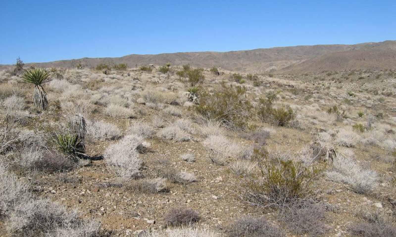
Production representative value (RV) is 315 pounds per acre, and depending on annual precipitation and annual forb production, ranges from 165 to 543 pounds per acre. Shrubs dominate this site, with burrobush (Ambrosia dumosa) dominant, and creosote bush (Larrea tridentata) co-dominant. A high diversity of secondary shrubs and subshrubs are present, and perennial grasses contribute a minor component. This site has similar properties to R030XB139CA, but it has additional moisture (lower solar radiation index, higher precipitation zone, or landscape position), which allows for greater total production and an increase in the importance of burrobrush.
The data in the following sections is from major (15% of map unit or greater) components only.
This is a group concept and provisional STM that also covers R030XB123CA, R030XB213CA, R030XD040CA.Associated sites
R030XB005NV Arid Active Alluvial Fans
This ecological site occurs on adjacent fan aprons. Creosote bush (Larrea tridentata) and burrobush (Ambrosia dumosa) are co-dominant.
R030XB077NV STEEP SOUTH SLOPE
This ecological site occurs on adjacent south-facing slopes. Brittlebush (Encelia farinosa) and creosote bush (Larrea tridentata) are dominant.
R030XB136CA Dry Wash
This ecological site occurs on adjacent ephemeral drainageways. Burrobrush (Hymenoclea salsola) and creosote bush (Larrea tridentata) are dominant.
R030XB139CA Shallow Dry Hill 4-6 P.Z.
This ecological site occurs on adjacent slopes with less available moisture. Creosote bush (Larrea tridentata) is dominant.
R030XB148CA Sandy Plain
This ecological site is found on adjacent fan aprons on fan remnants. Big galleta (Pleuraphis rigida) and Creosote bush (Larrea tridentata) are dominant species.
R030XB189CA Shallow Cool Hills
This ecological site occurs on adjacent slopes with a cool thermic soil temperature regime. Blackbrush (Coleogyne ramosissima) dominates and California juniper (Juniperus californica) is typically an important secondary species.
R030XB225CA Warm Sloping Pediments
This ecological site occurs on adjacent dissected pediments. Hall's shrubby spurge (Tetracoccus hallii) and burrobush (Ambrosia dumosa) are dominant.
R030XD003CA Hyperthermic Steep South Slopes
This ecological site occurs on adjacent, hyperthermic, typically south-facing slopes. Brittlebush (Encelia farinosa) is dominant.
R030XD040CA Hyperthermic Steep North Slopes
This ecological site occurs on adjacent, hyperthermic, typically north-facing slopes. Burrobush (Ambrosia dumosa) and Parish's goldeneye (Vigueira parishii) are important species.
R030XY128CA Broad, Gravelly, Hyperthermic Ephemeral Stream
This ecological site occurs in medium-sized drainageways adjacent to this site. Desert lavender (Hyptis emoryi), creosote bush (Larrea tridentata) and burrobrush (Hymenoclea salsola) are dominant species.
Similar sites
R030XB001NV LIMY HILL 5-7 P.Z.
This ecological site is similar, but receives a greater proportion of summer precipitation. Big galleta (Pleuraphis rigida) and low woollygrass (Dasyochloa pulchella) are the dominant grasses.
R030XB193CA Very Shallow To Moderately Deep Gravelly Slopes
This ecological site occurs on soils with an argillic horizon. Shrub diversity is higher, with burrobush (Ambrosia dumosa), Nevada ephedra (Ephedra nevadensis), Parish's goldeneye (Viguiera parishii), jojoba (Simmondsia chinensis) and waterjacket (Lycium andersonii) all important species.
R030XB139CA Shallow Dry Hill 4-6 P.Z.
This ecological site has less available moisture. Production is lower, and burrobush (Ambrosia dumosa) is a minor species.
R030XD001CA Hyperthermic Dry Hills
This ecological site occurs on slopes with a hyperthermic soil temperature regime. Shrub pecies composition is similar, but production is lower, and there is a negligible grass component.
R030XB146CA Volcanic Hill 5-7" P.Z.
This ecological site occurs on slopes with volcanic parent material. Eastern Mojave buckwheat (Eriogonum fasciculatum) and burrobush (Ambrosia dumosa) are co-dominant.
Table 1. Dominant plant species
Tree Not specified
Shrub (1) Ambrosia dumosa
(2) Larrea tridentataHerbaceous (1) Achnatherum speciosum
Physiographic features
This site occurs on sideslopes of fan remnants, hills and mountains on all exposures. Elevations range from 1800 to 5100 feet. Slopes may range from 2 to 75 percent, but slope gradients of 15 to 50 percent are most typical. Runoff class is low to very high.
Table 2. Representative physiographic features
Landforms (1) Fan remnant
(2) Mountain slope
(3) Hill
Flooding frequency None Ponding frequency None Elevation 1800 – 5100 ft Slope 2 – 75 % Aspect Aspect is not a significant factor Climatic features
The climate on this site is arid, and characterized by cool, somewhat moist winters and hot, dry summers. The average annual precipitation ranges from 3 to 8 inches with most falling as rain from November to March with a secondary, smaller peak following summer convection storms from July to September. Mean annual air temperature is 55 to 70 degrees F. The frost free period is 200 to 320 days. Freeze free period was not entered and defaults to zero.
Table 3 Representative climatic features
Frost-free period (average) 320 days Freeze-free period (average) Precipitation total (average) 10 in BarLineFigure 2. Monthly precipitation range
BarLineFigure 3. Monthly average minimum and maximum temperature
">Influencing water features
Soil features
The soils associated with this ecological site are typically very shallow to shallow over bedrock or a duripan, but soils may be very deep. Soils are typically loamy-skeletal or loamy in the particle control section. Surface textures are typically very to extremely gravelly or cobbly loamy sand and loam. Subsurface textures are typically loam, sandy loam, sandy clay loam and loamy sand with gravelly, stony and cobbly modifiers. These soils are well to excessively drained with very slow to moderately rapid permeability. The soils associated with this ecological site occur on mountain and hillslopes and formed from colluvium over residuum weathered from granite, mixed sources, gneiss, metamorphic rock, igneous rock, sandstone, siltstone and shale; or soils occur on steep sideslopes of fan remnants, and formed in alluvium derived from granite, gneiss, igneous rock, and mixed sources.
The associated soil series that are 15 percent or greater of any one map unit are:
Yuccabutte (Loamy-skeletal, mixed, superactive, thermic Typic Haplargids);
Crosgrain (Loamy-skeletal, mixed, superactive, thermic, shallow Typic Haplodurids);
Dime (Loamy-skeletal, mixed, superactive, thermic Typic Haplocalcids);
Fourcorners (Loamy-skeletal, mixed, superactive, thermic, shallow Typic Argidurids);
Shankba (Loamy-skeletal, mixed, superactive, calcareous, thermic, shallow Typic Torriorthents);
Xyzoic (Loamy-skeletal, mixed, superactive, calcareous, thermic, shallow Typic Torriorthents);
Crackerjack (Loamy, mixed, superactive, thermic, shallow Cambidic Haplodurids):
Fortirwin (Loamy, mixed, superactive, thermic, shallow Typic Argidurids):
Dalvord (Loamy-skeletal, mixed, superactive, calcareous, thermic Lithic Torriorthents);
Coyote (Sandy, mixed, thermic Durinodic Haplocalcids);
Pacific Mesa (Loamy-skeletal, mixed, superactive, thermic Lithic Haplocambids);
Coppermine (Loamy-skeletal, mixed, superactive, thermic, shallow Typic Haplargids);
Nellake (Loamy-skeletal, mixed, superactive, thermic Typic Haplargids);
Paintrocks (Loamy-skeletal, mixed, superactive, calcareous, thermic Lithic Torriorthents);
Desertqueen (Loamy, mixed, superactive, thermic, shallow Typic Haplargids);
Silvermine (Sandy, mixed, thermic, shallow Cambidic Haplodurids);
Langwell (Loamy, mixed, superactive, calcareous, thermic Lithic Torriorthents);
Seanna (Loamy-skeletal, mixed, superactive, calcareous, thermic, shallow Typic Torriorthents);
Artillery (Loamy-skeletal, mixed, superactive, thermic Lithic Haplargids);
Minhoyt (Loamy, mixed, superactive, thermic, shallow Typic Haplodurids);
Noble Pass (Loamy-skeletal, mixed, superactive, calcareous, thermic Lithic Torriorthents);
Contactmine (Fine-loamy, mixed, superactive, thermic Typic Haplargids);
Grubstake (Loamy, mixed, superactive, thermic, shallow, Typic Haplocambids);
Hexie (Coarse-loamy, mixed, superactive, thermic, Typic Haplargids).
This ecological site is also correlated with minor components (less than 15% of a mapunit). This information can be requested from NRCS.
This ecological site is correlated with the following soil survey areas, map units and soil components (Soil survey area; Mapunit symbol; Mapunit name; Component; phase; percent in alphabetical order by soil component):
CA794 Joshua Tree National Park, California
CA794; 1241;Meccapass-Seanna-Contactmine complex, 15 to 75 percent slopes; Seanna;;20;Contactmine;dry;20
CA794; 3295;Desertqueen-Hexie-Rock outcrop, 15 to 50 percent slopes;Contactmine;dry;3
CA794; 3297;Desertqueen-Contactmine-Seanna complex, 8 to 30 percent slopes; Desertqueen;warm;40; Contactmine;dry;20
CA794; 3340;Seanna-Grubstake-Pinecity complex, 30 to 75 percent slopes; Pacific Mesa;steep;65; Grubstake;moist;20; Seanna;;35; Seanna;;10; Contactmine;dry;4
CA794; 3110;Coppermine-Stranger complex, 8 to 50 percent slopes;Coppermine;cool;40; Typic Petrocalcids;;7
CA794; 4620;Stranger-Rock outcrop-Grubstake complex, 8 to 50 percent slopes;Grubstake;moist;20
CA794; 4830;Rock outcrop-Pinecity complex, 8 to 30 percent slopes;Grubstake;moist;2
CA794; 3120;Aguilareal-Rock outcrop-Blackeagle complex, 30 to 60 percent slopes;Lithic Haplocalcids;;3
CA794;4285;Typic Argidurids-Coppermine-Minhoyt complex, 4 to 30 percent slopes;Minhoyt;warm;25;Typic Argidurids;;35
CA794; 1240;Meccapass-Bulletproof-Rock outcrop complex, 30 to 75 percent slopes;Seanna;;5
CA794; 4041;Silvermine-Helendale-Burntshack association, 1 to 15 percent slopes;Silvermine;;40
CA794;4270;Yuccabutte extremely cobbly sandy loam, 8 to 30 percent slopes;Yuccabutte;extremely cobbly sandy loam;95
CA794; 4271;Yuccabutte-Arizo association, 2 to `5 percent slopes;Yuccabutte;steep;1
CA698 Mojave Desert Area, West Central Part, California
CA698;JIB1;Coppermine-Rock Outcrop Association, 8 to 60 percent slopes; Coppermine;;60;Coppermine;;5; Typic Haplocalcids;;5
CA698;JIB20;Coppermine-Hexie-Rock Outcrop Association, 8 to 60 percent slopes;Coppermine;;55; Coppermine;;10; Hexie;;20; Jiblette;;5
CA803 Colorado Desert Area, California
CA803;1240;Meccapass-Bulletproof-Rock outcrop complex, 30 to 75 percent slopes;Seanna;;5
CA697 National Training Center, Fort Irwin, California
CA697;415;Nellake-Arizo association, 4 to 15 percent slopes;Arizo;;35
CA697;105;Langwell-Artillery-Rock outcrop association, 8 to 30 percent slopes;Artillery;;30
CA697;245;Dalvord-Rock outcrop-Langwell complex, 15 to 50 percent slopes;Artillery;;5
CA697;350;Twobitter-Langwell complex, 4 to 15 percent slopes;Artillery;;3
CA697;540;Dalvord-Rock outcrop association, 15 to 50 percent slopes;Artillery;;5
CA697;114;Crosgrain complex, 2 to 8 percent slopes;Cambidic Haplodurids;;5
CA697;251;Cajon-Hollyhills-Spider association, 2 to 15 percent slopes;Coyote;;5
CA697;341;Coyote-Cronese complex, 2 to 30 percent slopes;Coyote;;65
CA697;130;Dime extremely gravelly coarse sandy loam, 4 to 30 percent slopes;Crackerjack;;5
CA697;211;Cavespring-Arizo-Cavespring very cobbly complex, 2 to 15 percent slopes;Crackerjack;;4
CA697;212;Cavespring very cobbly sandy loam, 15 to 30 percent slopes;Crackerjack;;5
CA697;227;Arizo-Luckyfuse-Fortirwin association, 2 to 8 percent slopes;Crackerjack;;5
CA697;261;Crosgrain-Fortirwin complex, 2 to 8 percent slopes;Crackerjack;;3
CA697;321;Fortirwin extremely cobbly loam, 4 to 15 percent slopes;Crackerjack;;4
CA697;480;Luckyfuse-Crackerjack association, 2 to 15 percent slopes;Crackerjack;;40
CA697;481;Luckyfuse-Arizo association, 2 to 4 percent slopes;Crackerjack;;10
CA697;490;Owlshead extremely gravelly sandy loam, 2 to 8 percent slopes;Crackerjack;;4
CA697;500;Crackerjack extremely gravelly sandy loam, 4 to 15 percent slopes;Crackerjack;;80
CA697;501;Crackerjack-Fortirwin association, 2 to 15 percent slopes;Crackerjack;;55
CA697;504;Crackerjack extremely gravelly sandy loam, 2 to 8 percent slopes;Crackerjack;;3
CA697;505;Crackerjack-Owlshead association, 8 to 30 percent slopes;Crackerjack;;45
CA697;550;Carrizo-Clegorpass-Carrizo frequently flooded association, 2 to 8 percent slopes;Crackerjack;;5
CA697;339;Eastrange-Dime association, 8 to 50 percent slopes;Cronese;;5
CA697;109;Juratrias-crosgrain association, 15 to 50 percent slopes;Crosgrain;;25
CA697;110;Crosgrain extremely gravelly loam, 8 to 30 percent slopes;Crosgrain;;85
CA697;111;Crosgrain-Twobitter association, 4 to 30 percent slopes;Crosgrain;;50
CA697;113;Crosgrain-Popups complex, 4 t0 15 percent slopes;Crosgrain;;45
CA697;121;Dalvord association, 15 to 50 percent slopes;Crosgrain;VERY GRAVELLY SANDY LOAM;5
CA697;200;Fourcorners extremely gravelly sandy loam, 4 to 30 percent slopes;Crosgrain;;2
CA697;211;Cavespring-Arizo-Cavespring very cobbly complex, 2 to 15 percent slopes;Crosgrain;;2
CA697;222;Arizo-Twobitter association, 2 to 8 percent slopes;Crosgrain;;1
CA697;310;Fortirwin-Crosgrain association, 2 to 15 percent slopes;Crosgrain;;25
CA697;339;Eastrange-Dime association, 8 to 50 percent slopes;Crosgrain;;2
CA697;450;Werewolf-Arizo association, 2 to 8 percent slopes;Crosgrain;;7
CA697;460;Lanip family, 2 to 8 percent slopes;Crosgrain;;3
CA697;470;Noble Pass-Rock outcrop association, 30 to 75 percent slopes;Crosgrain;;4
CA697;500;Crackerjack extremely gravelly sandy loam, 4 to 15 percent slopes;Crosgrain;;3
CA697;505;Crackerjack-Owlshead association, 8 to 30 percent slopes;Crosgrain;;1
CA697;105;Langwell-Artillery-Rock outcrop association, 8 to 30 percent slopes;Dalvord;;8
CA697;120;Dalvord-Angelpoint-Rock outcrop association, 30 to 75 percent slopes;Dalvord;;45
CA697;121;Dalvord association, 15 to 50 percent slopes;Dalvord;;25
CA697;122;Dalvord-Etinarg association, 15 to 50 percent slopes;Dalvord;EXTREMELY COBBLY;20
CA697;200;Fourcorners extremely gravelly sandy loam, 4 to 30 percent slopes;Dalvord;;3
CA697;245;Dalvord-Rock outcrop-Langwell complex, 15 to 50 percent slopes;Dalvord;;40
CA697;246;Rock outcrop-Etinarg association, 8 to 30 percent slopes;Dalvord;;4
CA697;256;Rock outcrop-Paintrocks complex, 15 to 50 percent slopes;Dalvord;;4
CA697;257;Paintrocks-Rock outcrop complex, 15 to 50 percent slopes;Dalvord;;4
CA697;415;Nellake-Arizo association, 4 to 15 percent slopes;Dalvord;;6
CA697;530;Xyzoic extremely gravelly sandy loam, 15 to 50 percent slopes;Dalvord;;5
CA697;540;Dalvord-Rock outcrop association, 15 to 50 percent slopes;Dalvord;;70
CA697;105;Langwell-Artillery-Rock outcrop association, 8 to 30 percent slopes;Dime;;3
CA697;130;Dime extremely gravelly coarse sandy loam, 4 to 30 percent slopes;Dime;;85
CA697;339;Eastrange-Dime association, 8 to 50 percent slopes;Dime;;35
CA697;360;Twobitter-Arizo association, 2 to 8 percent slopes;Dime;;4
CA697;393;Gravesumit-Thermopyl complex, 2 to 4 percent slopes;Dime;;2
CA697;502;Crackerjack-Dime association, 8 to 50 percent slopes;Dime;;40
CA697;321;Fortirwin extremely cobbly loam, 4 to 15 percent slopes;Fortirwin;;80
CA697;200;Fourcorners extremely gravelly sandy loam, 4 to 30 percent slopes;Fourcorners;;85
CA697;105;Langwell-Artillery-Rock outcrop association, 8 to 30 percent slopes;Langwell;;35
CA697;245;Dalvord-Rock outcrop-Langwell complex, 15 to 50 percent slopes;Langwell;;15
CA697;250;Cajon-Paintrocks-Langwell association, 2 to 8 percent slopes;Langwell;;15
CA697;255;Paintrocks-Rock outcrop complex, 4 to 15 percent slopes;Langwell;;5
CA697;256;Rock outcrop-Paintrocks complex, 15 to 50 percent slopes;Langwell;;5
CA697;257;Paintrocks-Rock outcrop complex, 15 to 50 percent slopes;Langwell;;5
CA697;350;Twobitter-Langwell complex, 4 to 15 percent slopes;Langwell;;25
CA697;393;Gravesumit-Thermopyl complex, 2 to 4 percent slopes;Langwell;;5
CA697;200;Fourcorners extremely gravelly sandy loam, 4 to 30 percent slopes;Nellake;;3
CA697;339;Eastrange-Dime association, 8 to 50 percent slopes;Nellake;;2
CA697;415;Nellake-Arizo association, 4 to 15 percent slopes;Nellake;;50
CA697;540;Dalvord-Rock outcrop association, 15 to 50 percent slopes;Nellake;;5
CA697;470;Noble Pass-Rock outcrop association, 30 to 75 percent slopes;Newera;;5
CA697;102;Mulespring-Newera-Noble Pass association, 15 to 75 percent slopes;Noble Pass;extremely gravelly sandy loam;15
CA697;181;Stonegold extremely cobbly loam, 2 to 8 percent slopes;Noble Pass;;8
CA697;212;Cavespring very cobbly sandy loam, 15 to 30 percent slopes;Noble Pass;;3
CA697;471;Noble Pass complex, 8 to 30 percent slopes;Noble Pass;;25
CA697;255;Paintrocks-Rock outcrop complex, 4 to 15 percent slopes;Paintrocks;;45
CA697;415;Nellake-Arizo association, 4 to 15 percent slopes;Paintrocks;;2
CA697;103;Shankba family, 30 to 75 percent slopes;Shankba family;;85
CA697;471;Noble Pass complex, 8 to 30 percent slopes;Typic Calciargids;;6
CA697;121;Dalvord association, 15 to 50 percent slopes;Typic Haplargids;EXTREMELY STONY SANDY LOAM;6
CA697;530;Xyzoic extremely gravelly sandy loam, 15 to 50 percent slopes;Xyzoic;;85
Table 4. Representative soil features
Parent material (1) Alluvium – granite
(2) Colluvium – granite
(3) Residuum – granite
Surface texture (1) Extremely gravelly sandy loam
(2) Extremely gravelly loam
(3) Extremely cobbly loam
Family particle size (1) Loamy
Drainage class Well drained to excessively drained Permeability class Very slow to moderately rapid Soil depth 1 – 0 in Surface fragment cover <=3" 0 – 90 % Surface fragment cover >3" 0 – 50 % Available water capacity
(0-40in)0.1 – 5.1 in Calcium carbonate equivalent
(0-40in)0 – 15 % Electrical conductivity
(0-40in)0 – 2 mmhos/cm Sodium adsorption ratio
(0-40in)0 – 5 Soil reaction (1:1 water)
(0-40in)6.1 – 9.4 Subsurface fragment volume <=3"
(Depth not specified)8 – 90 % Subsurface fragment volume >3"
(Depth not specified)0 – 15 % Ecological dynamics
Abiotic Factors
This site occurs on steep sideslopes of fan remnants, hillslopes and mountains on all exposures. Slope gradients of 15 to 50 percent are typical. Soils range from very shallow to very deep. This site occurs on slopes that are too warm and/or too dry to support blackbrush (Coleogyne ramosissima), but that retain sufficient moisture during the winter growing season to support the shallow-rooted burrobush.
Disturbance Dynamics
The disturbances impacting this ecological site include drought, invasion by non-native species and fire.
Desert regions are characterized by low mean annual precipitation and extreme variability in the amount of precipitation received in any year or decade (Hereford et al. 2006). Thus, episodic mortality in response to periods of drought is important in shaping desert community dynamics (Hereford et al. 2006, Miriti et al. 2007). Short-lived perennial shrubs demonstrate the highest rates of mortality (Webb et al. 2003, Bowers 2005, Hereford et al. 2006, Miriti et al. 2007), and annual species remain dormant in the soil seedbank (Beatley 1969, 1974, 1976). Long-lived shrubs and trees are more likely to exhibit branch-pruning, and or limited recruitment during drought (e.g. Hereford et al. 2006, Miriti et al. 2007), leading to reduced cover and biomass in drought-afflicted communities.
Non-native annual species such as red brome (Bromus rubens), Mediterranean grass (Schismus barbatus), redstem stork’s bill (Erodium cicutarium) and Asian mustard (Brassica tournefortii) have become naturalized throughout the Mojave Desert over the past century (Rickard and Beatley 1965, D'Antonio and Vitousek 1992, Brooks 1999, Reid et al. 2006, Norton et al. 2007). Like native annuals, nonnative annual cover and production is directly related to winter precipitation (Beatley 1969, Brooks and Berry 2006, Barrows et al. 2009). Steep slopes and rocky soils reduce the availability of soil moisture on this site, limiting biomass of annual species.
Invasion by non-native annual grasses has increased the flammability of Mojave Desert vegetation communities by providing a continuous fine fuel layer between widely spaced shrubs (Brown and Minnich 1986, Brooks 1999, Brooks et al. 2004, Rao and Allen 2010, Rao et al. 2010). The low potential for high biomass of annual species limits the continuity of fine fuels in this site, and reduces the susceptibility of this site to fire. However, during very wet years native annuals may reach high biomass, and since this site occurs on steep slopes over which fire may rapidly move, this site may burn during conditions of extreme fire behavior. In the rare event that this ecological site does burn, a burrobush dominated community recovers relatively rapidly, and although creosote bush communities may take decades to recover to pre-burn stature (Brown and Minnich , Engel and Abella 2011), the expanse of the creosote seedbank on surrounding landforms means that this ecological site is not considered at risk of transitioning to a fire-altered State.
State and transition model
Custom diagramStandard diagram
Figure 4. R030XB140CA
More interactive model formats are also available. View Interactive Models
Click on state and transition labels to scroll to the respective textEcosystem states
Land use 2 submodel, ecosystem states
State 2 submodel, plant communities
State 1
Historic StateState 1 represents the historic range of variability for this ecological site. This state no longer exists due to the ubiquitous naturalization of non-native species in the Mojave and Colorado Deserts. Drought and very rare fire were the natural disturbances influencing this ecological site.
Data for this State does not exist, but it would have been similar to State 2, except with only native species present. See State 2 narrative for more detailed information.
State 2
Reference StateState 2 represents the current range of variability for this site. Non-native annuals, including Mediterranean grass (Schismus barbatus) are naturalized in this plant community. Abundance varies with precipitation, but it is at least sparsely present (as current year's growth or present in the soil seedbank).
Community 2.1
Reference Plant Community
Figure 5. Community Phase 2.1
The reference plant community is characterized by widely spaced shrubs, 0.5 to 2 meters tall. Burrobush dominates, and creosote bush is a co-dominant species. A wide diversity of secondary shrubs may be present. Common species include white ratany (Krameria grayi), range ratany (Krameria erecta), Nevada jointfir (Ephedra nevadensis), and Mojave yucca (Yucca schidigera). Cactus species are typically present, and include Englemann’s hedgehog cactus (Echinocerus engelmannii), branched pencil cholla (Cylindropuntia ramosissima), Wiggins’ cholla (Cylindropuntia echninocarpa), beavertail cholla (Opuntia basilaris), and cottontop cactus (Echinocactus polycephalus). Subshrubs may make a significant contribution to annual production, and common species include Mojave aster (Xylorhiza tortifolia), wishbone bush (Mirabilis laevis var. villosa), brownplume wirelettuce (Stephanomeria pauciflora), desert trumpet (Eriogonum fasciculatum), and desert pepperweed (Lepidium fremontii). Perennial grasses are present at low levels, including big galleta (Pleuraphis rigida), desert needlegrass (Achnatherum speciosum), Indian ricegrass (Achnatherum hymenoides) and low woollygrass (Dasyochloa pulchella). The composition and abundance of annual vegetation differs from year to year, depending on the time and amount of precipitation. Common species include pincushion flower (Chaenactis fremontii), bristey fiddleneck (Amsinckia tessellata), curvenut combseed (Pectocarya recurvata), and smooth desert dandelion (Malacothrix glabrata), although many other species may be present. Pockets of cryptogamic crust have developed between the surface rock and vegetation.
The non-native annual forb redstem stork’s bill may be abundant, and the non-native annual grasses red brome and Mediterranean grass are often sparsely present.Figure 6. Annual production by plant type (representative values) or group (midpoint values)
Table 5. Annual production by plant type
Plant type Low
(lb/acre)Representative value
(lb/acre)High
(lb/acre)Shrub/Vine 165 246 328 Forb 0 63 150 Grass/Grasslike 0 5 55 Tree 0 0 10 Total 165 314 543 Table 6. Ground cover
Tree foliar cover 0% Shrub/vine/liana foliar cover 10-20% Grass/grasslike foliar cover 0-0% Forb foliar cover 0-0% Non-vascular plants 0% Biological crusts 0% Litter 0% Surface fragments >0.25" and <=3" 0% Surface fragments >3" 0% Bedrock 0% Water 0% Bare ground 0% Figure 7. Plant community growth curve (percent production by month). CA3004 , Burrobush XB. Growth starts in early spring, flowering and seed set occur by July. Dormancy occurs during the hot summer months. With sufficient summer/fall precipitation, some vegetation may break dormancy and produce a flush of new growth..
Jan Feb Mar Apr May Jun Jul Aug Sep Oct Nov Dec J F M A M J J A S O N D 0 5 25 35 20 0 0 10 5 0 0 0 Figure 8. Plant community growth curve (percent production by month). CA3015 , Creosote bush XB. Growth starts in early spring with flowering and seed set occurring by July. Dormancy occurs during the hot summer months. With sufficient summer/fall precipitation, some vegetation may break dormancy and produce a flush of growth..
Jan Feb Mar Apr May Jun Jul Aug Sep Oct Nov Dec J F M A M J J A S O N D 0 5 20 30 20 10 0 10 5 0 0 0 Figure 9. Plant community growth curve (percent production by month). CA3087 , Desert needlegrass. Growth begins in mid-winter and continues through summer, setting seed in late summer..
Jan Feb Mar Apr May Jun Jul Aug Sep Oct Nov Dec J F M A M J J A S O N D 0 5 15 25 20 15 15 5 0 0 0 0 Community 2.2
Drought ResponseThis community phase is characterized by an overall decline in cover due branch-pruning and lack of recruitment of creosote bush, mortality of burrobush, and lack of emergence of annual forbs. Creosote bush becomes more important in the drought response phase, with mortality of burrobush and other shorter lived species.
Community 2.3
Fire Regeneration CommunityThis community phase is characterized by the loss or severe decline of creosote bush from the plant community, since creosote bush is typically killed by fire (Brown and Minnich 1986). Burrobush has limited sprouting ability following fire, but relatively rapidly colonizes disturbed areas from adjacent seed sources, and will dominate the fire regeneration community. Native perennial forbs, perennial grasses, and annual forbs will initially increase. Species capable of resprouting after fire become more important, including Mojave yucca, range ratany, white ratany, and Nevada jointfir. By 19-20 years post-fire there is sparse cover of creosote bush and other secondary shrubs in burned communities (Engel and Abella 2011, Steers and Allen 2011).
Pathway 2.1a
Community 2.1 to 2.2This pathway occurs with prolonged or severe drought.
Pathway 2.1b
Community 2.1 to 2.3This pathway occurs with moderate to severe fire.
Pathway 2.2a
Community 2.2 to 2.1This pathway occurs with time and a return to average or above average climatic conditions.
Pathway 2.2b
Community 2.2 to 2.3This pathway occurs with moderate to severe fire, and takes place within one years of a very wet period when standing annual forb and grass biomass is still present.
Pathway 2.3a
Community 2.3 to 2.1This community pathway occurs with time and an absence of additional disturbance.
Transition 1
State 1 to 2This transition occurred with the naturalization of non-native species in this ecological site. Non-native species were introduced with settlement of the Southwest Desert region in the 1860s.
Additional community tables
Table 7. Community 2.1 plant community composition
Group Common name Symbol Scientific name Annual production () Foliar cover (%) Shrub/Vine1 Native shrubs 165–328 burrobush AMDU2 Ambrosia dumosa 30–300 4–22 white ratany KRGR Krameria grayi 30–300 0–4 creosote bush LATR2 Larrea tridentata 17–83 1–8 Nevada jointfir EPNE Ephedra nevadensis 4–52 1–3 Eastern Mojave buckwheat ERFA2 Eriogonum fasciculatum 0–52 0–3 spiny hopsage GRSP Grayia spinosa 0–52 0–3 Mojave yucca YUSC2 Yucca schidigera 3–52 1–3 cottontop cactus ECPO2 Echinocactus polycephalus 0–52 0–2 Engelmann's hedgehog cactus ECEN Echinocereus engelmannii 0–43 0–2 water jacket LYAN Lycium andersonii 0–18 0–1 littleleaf ratany KRER Krameria erecta 7–17 0–1 sweetbush BEJU Bebbia juncea 0–11 0–1 Wiggins' cholla CYEC3 Cylindropuntia echinocarpa 0–8 0–1 brittlebush ENFA Encelia farinosa 0–5 0–1 beavertail pricklypear OPBA2 Opuntia basilaris 0–5 0–1 Trans-Pecos false clapdaisy PSAR Pseudoclappia arenaria 0–4 0–1 jojoba SICH Simmondsia chinensis 0–4 0–1 branched pencil cholla CYRA9 Cylindropuntia ramosissima 0–4 0–1 Tree2 Trees 0–10 Joshua tree YUBR Yucca brevifolia 0–10 0–1 Forb3 Native Annual Forbs 0–55 desert Indianwheat PLOV Plantago ovata 0–35 0–4 pincushion flower CHFR Chaenactis fremontii 0–30 0–3 smooth desertdandelion MAGL3 Malacothrix glabrata 0–16 0–2 curvenut combseed PERE Pectocarya recurvata 0–16 0–2 miniature woollystar ERDI2 Eriastrum diffusum 0–13 0–1 bristly fiddleneck AMTE3 Amsinckia tessellata 0–12 0–1 4 Native Perennial Forbs 0–100 desert pepperweed LEFR2 Lepidium fremontii 0–50 0–2 Mojave woodyaster XYTO2 Xylorhiza tortifolia 0–50 0–2 desert globemallow SPAM2 Sphaeralcea ambigua 3–30 0–2 brownplume wirelettuce STPA4 Stephanomeria pauciflora 0–30 0–2 desert trumpet ERIN4 Eriogonum inflatum 0–30 0–2 wishbone-bush MILAV Mirabilis laevis var. villosa 0–30 0–1 6 Non-native annual forbs 0–126 redstem stork's bill ERCI6 Erodium cicutarium 0–126 0–12 Grass/Grasslike5 Native Perennial Grasses 0–55 desert needlegrass ACSP12 Achnatherum speciosum 0–35 0–2 low woollygrass DAPU7 Dasyochloa pulchella 0–30 0–2 Indian ricegrass ACHY Achnatherum hymenoides 0–30 0–2 big galleta PLRI3 Pleuraphis rigida 0–17 0–2 7 Non-native annual grasses 0–2 red brome BRRU2 Bromus rubens 0–1 0–1 common Mediterranean grass SCBA Schismus barbatus 0–1 0–1 Table 8. Community 2.2 plant community composition
Group Common name Symbol Scientific name Annual production () Foliar cover (%) Table 9. Community 2.3 plant community composition
Group Common name Symbol Scientific name Annual production () Foliar cover (%) Interpretations
Animal community
Mammals occurring on this site include desert woodrats, deer mice, black-tailed jackrabbits, antelope ground squirrels and pocket mice. Many small mammals browse creosotebush and consume its seeds. Feral burros also occur on this site.
Reptiles occurring on this site include desert horned lizards, desert collared lizards and chuckwallas. Depth to bedrock or a duripan is a restrictive feature to burrowing reptiles, such as the desert tortoise, although tortoise have been documented on this site.
Birds occurring on this site include chukars, black-throated and sage sparrows, rock wrens and common ravens.
LIVESTOCK GRAZING:
This site has limited use for livestock grazing due to the steep rocky slopes and low productivity. Burrobush is fair browse for cattle and horses, and fair to good browse for sheep. Burrobush is one of the major forage species of feral burros, especially in winter. Feral burros can eliminate this shrub through browsing and trampling. Creosote bush is unpalatable to livestock.
Recreational uses
This site is highly valued for open space and those interested in desert ecology. Flowering wildflowers and shrubs may also attract visitors during the spring.
Other information
Military Operations - The steep rocky slopes restrict extensive vehicle and foot traffic. Management for this site would be to protect it from excessive disturbance and maintain existing plant cover. Disturbance of the cryptogamic crust may result in increased soil erosion. Land clearing or other disturbances that destroy the vegetation and the soil crust and structure can result in soil compaction, reduced infiltration rates, accelerated erosion, soil blowing and barren areas.
Supporting information
Inventory data references
Sampling technique 12_ NV-ECS-1 _3_ SCS-Range 417 25+ Other CA794 Inventory Plots: 1249740011 12497040008 011311_01 COSP-05 COSP-07 COSP09 FRWA-04 FRWA-07 MVAL-3 POWA46 WAWA-02
Type locality
Location 1: San Bernardino County, CA Township/Range/Section T12N R2E S2 UTM zone N UTM northing 3891391 UTM easting 524120 General legal description NE1/4 Sec 2, T12N R2E Approximately 7 miles southwest of Fort Irwin, CA Langford Well Quadrangle UTM 11S 0524120e 3891391n (Datum=NAS-C) San Bernardino Co., CA Other references
Barrows, C. W., E. B. Allen, M. L. Brooks, and M. F. Allen. 2009. Effects of an invasive plant on a desert sand dune landscape. Biological Invasions 11:673-686.
Beatley, J. C. 1969. Dependence of desert rodents on winter annuals and precipitation. Ecology 50:721-724.
Beatley, J. C. 1974. Effects of rainfall and temperature on the distribution and behavior of Larrea tridentata (Creosote-bush) in the Mojave Desert of Nevada. Ecology 55:245-261.
Beatley, J. C. 1976. Rainfall and fluctuating plant populations in relation to distributions and numbers of desert rodents in southern Nevada. Oecologia 24:21-42.
Bowers, J. E. 2005. Effects of drought on shrub survival and longevity in the northern Sonoran Desert. Journal of the Torrey Botanical Society 132:421-431.
Brooks, M. L. 1999. Habitat invasibility and dominance by alien annual plants in the western Mojave Desert. Biological Invasions 1:325-337.
Brooks, M. L. and K. H. Berry. 2006. Dominance and environmental correlates of alien annual plants in the Mojave Desert, USA. Journal of Arid Environments 67:100-124.
Brooks, M. L., C. M. D'Antonio, D. M. Richardson, J. B. Grace, J. E. Keeley, J. M. DiTomaso, R. J. Hobbs, M. Pellant, and D. Pyke. 2004. Effects of invasive alien plants on fire regimes. Bioscience 54:677-689.
Brown, D. E. and R. A. Minnich. 1986. Fire and Changes in Creosote Bush Scrub of the Western Sonoran Desert, California. American Midland Naturalist 116:411-422.
D'Antonio, C. M. and P. M. Vitousek. 1992. Biological invasions by exotic grasses, the grass/fire cycle, and global change. Annual Review of Ecology and Systematics 23:63-87.
Engel, E. C. and S. R. Abella. 2011. Vegetation recovery in a desert landscape after wildfires: influences of community type, time since fire and contingency effects. Journal of Applied Ecology 48:1401-1410.
Hereford, R., R. H. Webb, and C. I. Longpre. 2006. Precipitation history and ecosystem response to multidecadal precipitation variability in the Mojave Desert region, 1893-2001. Journal of Arid Environments 67:13-34.
Miriti, M. N., S. Rodriguez-Buritica, S. J. Wright, and H. F. Howe. 2007. Episodic death across species of desert shrubs. Ecology 88:32-36.
Norton, J. B., T. A. Monaco, and U. Norton. 2007. Mediterranean annual grasses in western North America: kids in a candy store. Plant Soil 298:1-5.
Rao, L. E. and E. B. Allen. 2010. Combined effects of precipitation and nitrogen deposition on native and invasive winter annual production in California deserts. Oecologia 162:1035-1046.
Rao, L. E., E. B. Allen, and T. M. Meixner. 2010. Risk-based determination of critical nitrogen deposition loads for fire spread in southern California deserts. Ecological Applications 20:1320-1335.
Reid, C. R., S. Goodrich, and J. E. Bowns. 2006. Cheatgrass and red brome: history and biology of two invaders. Pages 27-32 in Shrublands under fire: disturbance and recovery in a changing world. U.S. Department of Agriculture, Forest Service, Rocky Mountain Research Station, Cedar City, Utah.
Rickard, W. H. and J. C. Beatley. 1965. Canopy-coverage of the desert shrub vegetation mosaic of the Nevada test site. Ecology 46:524-529.
Sawyer, J. O., T. Keeler-Woolf, and J. M. Evans. 2009. A manual of California vegetation. 2nd edition. California Native Plant Society, Sacramento, California.
Webb, R. H., M. B. Muroy, T. C. Esque, D. E. Boyer, L. A. DeFalco, D. F. Haines, D. Oldershaw, S. J. Scoles, K. A. Thomas, J. B. Blainey, and P. A. Medica. 2003. Perennial vegetation data from permanent plots on the Nevada Test Site, Nye County, Nevada. U.S. Geological Society, Tucson, AZ.
Contributors
Alice Lee Miller
P. Novak-EcheniqueApproval
Kendra Moseley, 10/21/2024
Rangeland health reference sheet
Interpreting Indicators of Rangeland Health is a qualitative assessment protocol used to determine ecosystem condition based on benchmark characteristics described in the Reference Sheet. A suite of 17 (or more) indicators are typically considered in an assessment. The ecological site(s) representative of an assessment location must be known prior to applying the protocol and must be verified based on soils and climate. Current plant community cannot be used to identify the ecological site.
Author(s)/participant(s) P.Novak-Echenique Contact for lead author State Rangeland Management Specialist Date 07/14/2009 Approved by Approval date Composition (Indicators 10 and 12) based on Annual Production Indicators
-
Number and extent of rills:
Rills are none. Rock fragments armor the soil surface against erosion. -
Presence of water flow patterns:
Water flow patterns are none to rare. A few may on steeper slopes (short <1m) after summer convection storms. -
Number and height of erosional pedestals or terracettes:
Pedestals and terracettes are none. -
Bare ground from Ecological Site Description or other studies (rock, litter, lichen, moss, plant canopy are not bare ground):
Bare ground is variable (15-25%), depending on amount of surface rock fragments. -
Number of gullies and erosion associated with gullies:
None. Natural drainages may be observed on steeper side slopes. -
Extent of wind scoured, blowouts and/or depositional areas:
None -
Amount of litter movement (describe size and distance expected to travel):
Litter typically remains in place. Fine litter (foliage from grasses and annual and perennial forbs) may move the distance of slope length (<10 ft) during intense summer convection storms or rapid snowmelt events. Persistent litter (large woody material) will remain in place expect during large rainfall events. -
Soil surface (top few mm) resistance to erosion (stability values are averages - most sites will show a range of values):
Soil stability values should be 3 to 6 depending on soil textures and canopy cover. (To be field tested.) -
Soil surface structure and SOM content (include type of structure and A-horizon color and thickness):
Soil surface structure is typically weak thin to medium platy. Soil surface colors are light and the soils have an ochric epipedon. Organic matter of the surface 2 to 3 inches is less than 1 percent. -
Effect of community phase composition (relative proportion of different functional groups) and spatial distribution on infiltration and runoff:
Sparse shrub canopy (10-15%) and associated litter provide some protection from raindrop impact. -
Presence and thickness of compaction layer (usually none; describe soil profile features which may be mistaken for compaction on this site):
None. Subangular blocky structure, calcic or petrocalcic horizons are not to be interpreted as compacted layers. -
Functional/Structural Groups (list in order of descending dominance by above-ground annual-production or live foliar cover using symbols: >>, >, = to indicate much greater than, greater than, and equal to):
Dominant:
white bursage > creosotebush > associated desert shrubs >Sub-dominant:
warm-season perennial grasses > perennial forbs > annual forbs > cool-season perennial grassesOther:
succulents, microbiotic crustsAdditional:
-
Amount of plant mortality and decadence (include which functional groups are expected to show mortality or decadence):
Dead branches within individual shrubs are common and standing dead shrub canopy material may be as much as 25% of total woody canopy. -
Average percent litter cover (%) and depth ( in):
Between plant interspaces 5-15% and depth of litter is ±¼ inch. Litter is concentrated under shrubs and generally stays in place. -
Expected annual annual-production (this is TOTAL above-ground annual-production, not just forage annual-production):
For normal or average growing season ~250 lbs/ac. Favorable years ±350 lbs/ac and unfavorable years ±100 lbs/ac. -
Potential invasive (including noxious) species (native and non-native). List species which BOTH characterize degraded states and have the potential to become a dominant or co-dominant species on the ecological site if their future establishment and growth is not actively controlled by management interventions. Species that become dominant for only one to several years (e.g., short-term response to drought or wildfire) are not invasive plants. Note that unlike other indicators, we are describing what is NOT expected in the reference state for the ecological site:
Red brome, red-stem filaree, mustards, and Mediterranean grass are potential invaders on this site. -
Perennial plant reproductive capability:
All functional groups should reproduce in average and above-average rainfall years. Little growth and reproduction occurs during extreme drought and extended drought periods.
Print Options
Sections
Font
AAAAOther
PrintThe Ecosystem Dynamics Interpretive Tool is an information system framework developed by the USDA-ARS Jornada Experimental Range, USDA Natural Resources Conservation Service, and New Mexico State University.
Accessibility statement