
Natural Resources
Conservation Service
Ecological site R029XY186CA
Sandy Slope
10-12" p.z.
Last updated: 2/20/2025
Accessed: 10/06/2026
-
Search


Major Land Resource Area or ecological site by name and/or ID.
PreviousSectionsNextGeneral information
Provisional. A provisional ecological site description has undergone quality control and quality assurance review. It contains a working state and transition model and enough information to identify the ecological site.
MLRA notes
Major Land Resource Area (MLRA): 029X–Southern Nevada Basin and Range
The Southern Nevada Basin and Range MLRA (29) represents the transition from the Mojave Desert to the Great Basin. It is cooler and wetter than the Mojave. It is warmer and typically receives more summer precipitation than the Great Basin. This area is in Nevada (73 percent), California (25 percent), and Utah (2 percent). It makes up about 26,295 square miles (68,140 square kilometers). Numerous national forests occur in the area, including the San Bernardino, Angeles, Sequoia, Inyo, Humboldt-Toiyabe, and Dixie National Forests. Portions of Death Valley National Monument, the Nuclear Regulatory Commission’s Nevada Test Site, the Hawthorne Ammunition Depot, and the Nellis Air Force Range in Nevada and the China Lake Naval Weapons Center in California also are in this MLRA. The northeast part of the Paiute Indian Reservation and the southern third of the Walker River Indian Reservation are in the part of this MLRA in Nevada, and the Lone Pine, Fort Independence, and Big Pine Indian Reservations are in the part in California.
Physiography:
The entire area is in the Great Basin Section of the Basin and Range Province of the Intermontane Plateaus. The area of broad, nearly level, aggraded desert basins and valleys between a series of mountain ranges trending north to south. The basins are bordered by sloping fans and pluvial lake terraces. The mountains are uplifted fault blocks with steep side slopes and not well dissected due to limited annual precipitation. Most of the valleys in this MLRA are closed basins or bolsons containing sinks or playa lakes.
Geology:
The mountains are dominated by Pliocene and Miocene andesite and basalt rocks, Paleozoic and Precambrian carbonate rocks prominent in some areas. Scattered outcrops of older Tertiary intrusives and very young tuffaceous sediments (Pliocene and Miocene) are in the western and eastern thirds of this MLRA. The valleys consist mostly of alluvial fill and playa deposits at the lowest elevations in the closed basins.
Climate:
The average annual precipitation is 3 to 12 inches (75 to 305 millimeters) in most of this area. It may be as high as 29 inches (735 millimeters), on the higher mountain slopes. Most of the rainfall occurs as high-intensity, convective thunderstorms during the growing season. Summers are dry, but sporadic storms are common in July and August.
Water Resources:
Water resources are scarce. Ground water and surface water sources are limited. Streams are small and intermittent. Quality of surface water in naturally degraded as streams cross area of valley fill effected by dissolved salts. Irrigation water may raise the levels of dissolved salts and suspended sediments causing contamination.
Soils:
Dominant soil orders include Entisols and Aridisols.Ecological site concept
The Sandy Slope 10-12" p.z. Ecological Site is on mountains. It is on backslopes that typically have a north-facing aspect, but may be on slopes with an east-facing aspect. Slopes range from 15 to 60 percent, but are typically between 30 and 60 percent. The soils are formed from colluvium and residuum derived and weathered from granite. Soils are very deep and sandy throughout the profile with no soil development.
Associated sites
F029XY001CA Shallow Sandy Slope
This a woodland community found at higher elevations on upper backslopes of mountains. It is typically found on north and east-facing slopes.
Table 1. Dominant plant species
Tree Not specified
Shrub (1) Artemisia tridentata ssp. vaseyana
(2) Eriogonum wrightiiHerbaceous (1) Poa secunda
(2) Achnatherum speciosumPhysiographic features
The Sandy Slope 10-12" p.z. Ecological Site is on mountains. It is on backslopes that typically have a north-facing aspect, but may be found on slopes with an east-facing aspect. Slopes range from 15 to 60 percent, but are typically between 30 and 60 percent.
Table 2. Representative physiographic features
Landforms (1) Mountain
Runoff class Medium to very high Flooding frequency None Ponding frequency None Elevation 2600 – 6000 ft Slope 15 – 60 % Water table depth 72 – 0 in Aspect N, NE, E Climatic features
The climate associated with this site is arid, characterized by cool, moist winters and hot, dry summers. Mean annual air temperature is 50 to 56 degrees F. Monthly minimum temperature averages range from 30 to 80 degrees F (-1 to 27 degrees C). Monthly maximum temperature averages range from 60 to 110 degrees F (16 to 43 degrees C) (CSU 2002).
Average annual rainfall is between 2 and 8 inches (50 to 205 millimeters) (USDA 2006). Snowfall is more common at elevations above 4000 feet (1,220 meters), but it may not occur every year (WRCC, 2002).
Spring is typically the windiest season, with winds averaging 10-15 miles per hour (WRCC, 2002). Winds in excess of 25 miles per hour and gusts in excess of 50 miles per hour are not uncommon (CSU, 2002).
Although half of the Jawbone-Butterbredt ACEC Soil Survey is in the Mojave Desert (MLRA 30), the western and northwestern areas of the survey transition into the Southern Nevada Basin and Range (MLRA 29). As the Mojave Desert transitions into the Southern Nevada Basin and Range, the temperature range generally becomes cooler (WRCC, 2002). Precipitation as rain and as snow also increases (USDA, 2006). This survey area has a wide range of precipitation due to its location. Where the Mojave Desert influences are stronger, average annual precipitation ranges from 5 to 7 inches (127 to 178 millimeters). Where the Southern Nevada Basin and Range influences are stronger, average annual precipitation commonly ranges from 7 to 9 inches (178 to 229 millimeters), and may range up to 12 inches (305 millimeters) annually (WRCC 2002). At elevations above 4,000 feet (1,370 meters), average annual snowfall may reach 20 inches (WRCC, 2002).
The data from the following climate stations were used to describe the climate in the Jawbone-Butterbredt ACEC Soil Survey (station number in parentheses):
Inyokern, CA (044278)
Mojave, CA (045756)
Tehachapi, CA (048826)
"Maximum monthly precipitation" represents average monthly precipitation.Table 3 Representative climatic features
Frost-free period (characteristic range) 170-210 days Freeze-free period (characteristic range) 200-240 days Precipitation total (characteristic range) 10-10 in Frost-free period (actual range) 150-210 days Freeze-free period (actual range) 200-250 days Precipitation total (actual range) 10-10 in Frost-free period (average) 190 days Freeze-free period (average) 220 days Precipitation total (average) 10 in Characteristic rangeActual rangeBarLineFigure 1. Monthly precipitation range
Characteristic rangeActual rangeBarLineFigure 2. Monthly minimum temperature range
Characteristic rangeActual rangeBarLineFigure 3. Monthly maximum temperature range
BarLineFigure 4. Monthly average minimum and maximum temperature
Figure 5. Annual precipitation pattern
Figure 6 Annual average temperature pattern
Climate stations used
-
(1) TEHACHAPI [USC00048826], Tehachapi, CA
-
(2) INYOKERN [USC00044278], Inyokern, CA
-
(3) MOJAVE [USC00045756], Mojave, CA
">Influencing water features
There are no water features associated with this site.
Soil features
The soils are formed from colluvium and residuum derived and weathered from granite. Soils are very deep and sandy throughout the profile with no soil development. They are somewhat excessively drained, and permeability is moderately rapid to rapid. Available water capacity is very low to low. The soils classify as mixed, mesic Xeric Torripsamments.
Soil survey area - Map unit symbol - Component
CA682 - 5205 - Grandora (major)
CA682 - 5210 - Grandora (major)Table 4. Representative soil features
Parent material (1) Colluvium – granite
(2) Residuum – granite
(3) Colluvium – granitoid
(4) Residuum – granitoid
Surface texture (1) Coarse sand
(2) Gravelly loamy coarse sand
Family particle size (1) Sandy
Drainage class Somewhat excessively drained Permeability class Moderately rapid to rapid Soil depth 60 – 0 in Surface fragment cover <=3" 5 – 80 % Surface fragment cover >3" Not specified Available water capacity
(0-40in)2.3 – 4.8 in Calcium carbonate equivalent
(0-40in)0 – 1 % Electrical conductivity
(0-40in)0 – 2 mmhos/cm Sodium adsorption ratio
(0-40in)0 – 5 Soil reaction (1:1 water)
(0-40in)6.6 – 7.8 Subsurface fragment volume <=3"
(Depth not specified)5 – 35 % Subsurface fragment volume >3"
(Depth not specified)0 – 45 % Ecological dynamics
This ecological site occurs predominantly on north-facing slopes. Relative to adjacent areas, these slopes have cooler temperatures and water is plant available for longer periods of the year. These cooler and wetter conditions provide a favorable growing environment for the dominant species on this ecosite, mountain big sagebrush (Artemisia tridentata ssp. vaseyana).
Mountain big sagebrush is a deep-rooted, long-lived, late seral species that is widely distributed in the western U.S (Johnson, 2000). It reproduces by seed, and recruitment of individuals occurs in pulses, but conditions favorable for high recruitment are not well known. Warmer temperatures have promoted germination under simulated spring germination conditions (Young et al., 1991). Below-average precipitation during the first growing season, possibly associated with warmer temperatures, has also been weakly associated with higher recruitment (Maier et al., 2001). However, based on its relatively low tolerance of heat and drought, more severe conditions of warm temperatures and drought would likely have a negative effect on recruitment.
Sandberg bluegrass (Poa secunda) and desert needlegrass (Achnatherum speciosum) are major herbaceous species on this ecosite. They persist where there is no or minimal canopy cover, and sagebrush may reduce their presence by shading them out.
Wildfire may significantly impact sagebrush communities. Sagebrush is readily injured or killed by fire, and it does not resprout (Johnson, 2000). Following a fire, dominant species will be those that resprout or easily colonize disturbed areas. These include grasses such as desert needlegrass (Achnatherum speciosum) and Sandberg bluegrass (Poa secunda), and short-lived shrubs such as buckwheat species (Eriogonum spp.). Mormon tea (Ephedra viridis) is often found in late seral stages, but may be present following a fire because it can resprout if not severely burned (Anderson, 2001). Reestablishment of sagebrush by seed may take 15-30 years (Harris, 2006 personal communication; Johnson, 2000). As it grows, sagebrush will shade out or outlive other species. Fire return intervals for this area are approximately 130 to 150 years (Harris, 2006 email communication).State and transition model
Custom diagramStandard diagramMore interactive model formats are also available. View Interactive Models
Click on state and transition labels to scroll to the respective textEcosystem states
State 1 submodel, plant communities
State 1
Big sagebrushCommunity 1.1
Big sagebrush
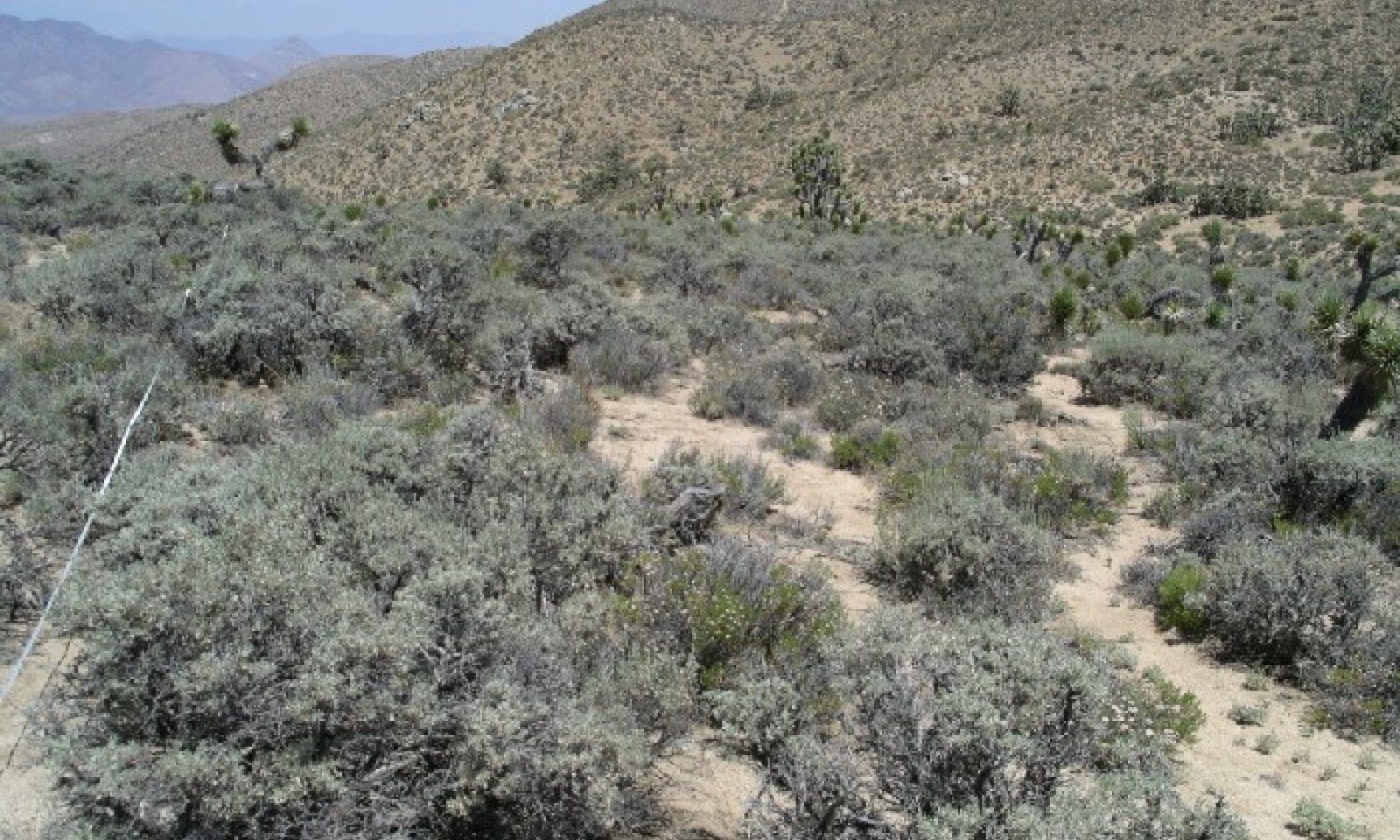
Figure 7. Sagebrush
The interpretive plant community is the reference plant community prior to European colonization.
This community occurs below the pinyon pine (Pinus monophylla) woodland. Sagebrush is the dominant shrub in the community. Wright’s buckwheat (Eriogonum wrightii), Sandberg bluegrass (Poa secunda), and desert needlegrass (Achnatherum speciosum) are other important species in this community. Mormon tea (Ephedra viridis) is also an important species that occurs in late seral communities. Small amounts of California juniper (Juniperus californica) and singleleaf pinyon (Pinus monophylla) are present in this ecosite, but their distribution does not suggest encroachment into this ecosite from surrounding areas.
The potential plant community of the site is 85 percent shrubs, 10 percent perennial grasses, and 5 percent annual forbs.
"Typical Annual Production of Understory Species Under Low, RV, and High Canopy Cover" represents the contribution of each species to total vegetation cover, not production.Figure 8. Annual production by plant type (representative values) or group (midpoint values)
Table 5. Annual production by plant type
Plant type Low
(lb/acre)Representative value
(lb/acre)High
(lb/acre)Shrub/Vine 801 974 1147 Grass/Grasslike 90 110 130 Forb 9 11 13 Tree 0 5 10 Total 900 1100 1300 Table 6. Ground cover
Tree foliar cover 0% Shrub/vine/liana foliar cover 30-40% Grass/grasslike foliar cover 0-10% Forb foliar cover 0-0% Non-vascular plants 0% Biological crusts 0% Litter 0% Surface fragments >0.25" and <=3" 0% Surface fragments >3" 0% Bedrock 0% Water 0% Bare ground 0% Table 7. Soil surface cover
Tree basal cover 0% Shrub/vine/liana basal cover 20-20% Grass/grasslike basal cover 0-0% Forb basal cover 0-0% Non-vascular plants 0% Biological crusts 0% Litter 0-0% Surface fragments >0.25" and <=3" 0% Surface fragments >3" 0% Bedrock 0% Water 0% Bare ground 0% Table 8. Canopy structure (% cover)
Height Above Ground (ft) Tree Shrub/Vine Grass/
GrasslikeForb <0.5 – – – 2-3% >0.5 <= 1 – – – – >1 <= 2 – 10-15% 3-5% – >2 <= 4.5 – 20-25% – – >4.5 <= 13 – – – – >13 <= 40 – – – – >40 <= 80 – – – – >80 <= 120 – – – – >120 – – – – Additional community tables
Table 9. Community 1.1 plant community composition
Group Common name Symbol Scientific name Annual production () Foliar cover (%) Shrub/Vine1 Perennial Shrubs 801–1147 basin big sagebrush ARTRT Artemisia tridentata ssp. tridentata 538–620 – narrowleaf goldenbush ERLI6 Ericameria linearifolia 68–156 – Joshua tree YUBR Yucca brevifolia 108–156 – Eastern Mojave buckwheat ERFA2 Eriogonum fasciculatum 50–130 – peach thorn LYCO2 Lycium cooperi 18–26 – antelope bitterbrush PUTR2 Purshia tridentata 9–13 – blackbrush CORA Coleogyne ramosissima 1–13 – fourwing saltbush ATCA2 Atriplex canescens 0–10 – California juniper JUCA7 Juniperus californica 0–10 – Grass/Grasslike2 Perennial Grasses 90–130 Sandberg bluegrass POSE Poa secunda 54–78 – desert needlegrass ACSP12 Achnatherum speciosum 18–26 – squirreltail ELEL5 Elymus elymoides 18–26 – Forb3 Perennial Forbs 9–13 tarragon ARDR4 Artemisia dracunculus 9–13 – Tree4 Trees 0–10 singleleaf pinyon PIMO Pinus monophylla 0–10 – Interpretations
Animal community
Sagebrush is an important cover and food source for wildlife. It is valuable winter forage for many species. Sandberg bluegrass and desert needlegrass are also important forage species.
Sagebrush is poor to fair forage for domestic livestock (Sampson and Jesperson, 1963). Grasses are preferred, especially when new growth is present. Livestock use of this ecosite may be limited by steep slopes and few water sources.Supporting information
Inventory data references
3 Line-point intercept transects (2006) 2 SCS Range 417 Production and Composition Record (2004)
Type locality
Location 1: Kern County, CA UTM zone N UTM northing 3928632 UTM easting 397009 Latitude 35° 29′ 45″ Longitude 118° 8′ 7″ General legal description This site is located in the Jawbone-Butterbredt ACEC off SC47 where it crosses the Pacific Crest Trail. Other references
Anderson, Michelle D. 2001. Ephedra viridis. In: Fire Effects Information System, [Online]. U.S. Department of Agriculture, Forest Service, Rocky Mountain Research Station, Fire Sciences Laboratory (Producer). Available: http://www.fs.fed.us/database/feis/ [ 2006, November 30].
California State University (CSU) Desert Studies Center. 2002. Desert Climate. CSU Desert Studies Center, Soda Springs, CA. Online. http://biology.fullerton.edu/facilities/dsc/zz_climate.html. Accessed 28 November 2006.
Johnson, Kathleen A. 2000. Artemisia tridentata spp. vaseyana. In: Fire Effects Information System, [Online]. U.S. Department of Agriculture, Forest Service, Rocky Mountain Research Station, Fire Sciences Laboratory (Producer). Available: http://www.fs.fed.us/database/feis/ [ 2006, November 30].
Harris, Glenn. Natural Resources Specialist, Bureau of Land Management Ridgecrest Field Office, Ridgecrest, CA. Personal communication. November 8, 2006. Progress Field Review. Jawbone-Butterbredt ACEC Soil Survey, Mojave Desert Area, Northwest Part (CA682)
Harris, Glenn. Natural Resources Specialist, Bureau of Land Management Ridgecrest Field Office, Ridgecrest, CA. Email communication. August 30, 2006
Maier, A.M, B.L. Perryman, R.A. Olson, and A.L. Hild. 2001. Climatic influences on recruitment of 3 subspecies of Artemisia tridentata. Journal of Range Management 54: 699-703.
Sampson, A.W. and B.S. Jesperson. 1963. California range brushlands and browse plants. Publication 4010. Division of Agriculture and Natural Resources, University of California.
United States Department of Agriculture (USDA), Natural Resources Conservation Service. 2006. Land Resource Regions and Major Land Resource Areas of the United States, the Caribbean, and the Pacific Basin. U.S. Department of Agriculture Handbook 296.
Western Regional Climate Center (WRCC). 2002. Western U.S. Climate Historical Summaries [Online]. Desert Research Institute, Reno, NV. Online. http://www.wrcc.dri.edu/Climsum.html. Accessed 28 November 2006.
Young, J.A. D.E. Palmquist, and R.A. Evans. 1991. Temperature profiles for germination of big sagebrush seeds from native stands. Journal of Range Management 44: 385-390.
Locator map image generated using TopoZone.com © 1999-2004 Maps a la carte, Inc. - All rights reserved.
Contributors
Heath M. McAllister
Approval
Kendra Moseley, 2/20/2025
Rangeland health reference sheet
Interpreting Indicators of Rangeland Health is a qualitative assessment protocol used to determine ecosystem condition based on benchmark characteristics described in the Reference Sheet. A suite of 17 (or more) indicators are typically considered in an assessment. The ecological site(s) representative of an assessment location must be known prior to applying the protocol and must be verified based on soils and climate. Current plant community cannot be used to identify the ecological site.
Author(s)/participant(s) Contact for lead author Date 10/06/2026 Approved by Approval date Composition (Indicators 10 and 12) based on Annual Production Indicators
-
Number and extent of rills:
-
Presence of water flow patterns:
-
Number and height of erosional pedestals or terracettes:
-
Bare ground from Ecological Site Description or other studies (rock, litter, lichen, moss, plant canopy are not bare ground):
-
Number of gullies and erosion associated with gullies:
-
Extent of wind scoured, blowouts and/or depositional areas:
-
Amount of litter movement (describe size and distance expected to travel):
-
Soil surface (top few mm) resistance to erosion (stability values are averages - most sites will show a range of values):
-
Soil surface structure and SOM content (include type of structure and A-horizon color and thickness):
-
Effect of community phase composition (relative proportion of different functional groups) and spatial distribution on infiltration and runoff:
-
Presence and thickness of compaction layer (usually none; describe soil profile features which may be mistaken for compaction on this site):
-
Functional/Structural Groups (list in order of descending dominance by above-ground annual-production or live foliar cover using symbols: >>, >, = to indicate much greater than, greater than, and equal to):
Dominant:
Sub-dominant:
Other:
Additional:
-
Amount of plant mortality and decadence (include which functional groups are expected to show mortality or decadence):
-
Average percent litter cover (%) and depth ( in):
-
Expected annual annual-production (this is TOTAL above-ground annual-production, not just forage annual-production):
-
Potential invasive (including noxious) species (native and non-native). List species which BOTH characterize degraded states and have the potential to become a dominant or co-dominant species on the ecological site if their future establishment and growth is not actively controlled by management interventions. Species that become dominant for only one to several years (e.g., short-term response to drought or wildfire) are not invasive plants. Note that unlike other indicators, we are describing what is NOT expected in the reference state for the ecological site:
-
Perennial plant reproductive capability:
Print Options
Sections
Font
AAAAOther
PrintThe Ecosystem Dynamics Interpretive Tool is an information system framework developed by the USDA-ARS Jornada Experimental Range, USDA Natural Resources Conservation Service, and New Mexico State University.
Accessibility statement


