
Natural Resources
Conservation Service
Ecological site R028AY238UT
Semidesert Shallow Loam (Utah Juniper-Bluebunch Wheatgrass) North
Last updated: 5/02/2025
Accessed: 08/30/2026
-
Search


Major Land Resource Area or ecological site by name and/or ID.
PreviousSectionsNextGeneral information
Provisional. A provisional ecological site description has undergone quality control and quality assurance review. It contains a working state and transition model and enough information to identify the ecological site.
Click to explore map
Figure 1. Mapped extent
Areas shown in blue indicate the maximum mapped extent of this ecological site. Other ecological sites likely occur within the highlighted areas. It is also possible for this ecological site to occur outside of highlighted areas if detailed soil survey has not been completed or recently updated.
MLRA notes
Major Land Resource Area (MLRA): 028A–Ancient Lake Bonneville
MLRA 28A occurs in Utah (82 percent), Nevada (16 percent), and Idaho (2 percent). It encompasses approximately 36,775 square miles (95,246 square kilometers). A large area west and southwest of Great Salt Lake is a salty playa. This area is the farthest eastern extent of the Great Basin Section of the Basin and Range Province of the Intermontane Plateaus. It is an area of nearly level basins between widely separated mountain ranges trending north to south. The basins are bordered by long, gently sloping alluvial fans. The mountains are uplifted fault blocks with steep side slopes. Most of the valleys are closed basins containing sinks or playa lakes. Elevation ranges from 3,950 to 6,560 feet (1,204 to 2000 meters) in the basins and from 6,560 to 11,150 feet (1996 to 3398 meters) in the mountains. Much of the MLRA has alluvial valley fill and playa lakebed deposits at the surface from pluvial Lake Bonneville, which dominated this MLRA 13,000 years ago. A level line of remnant lake terraces on some mountain slopes indicates the former extent of this glacial lake. The Great Salt Lake is what remains of the pluvial lake.
Mountains in the interior of this MLRA consist of tilted blocks of marine sediments from Cambrian to Mississippian age with scattered outcrops of Tertiary continental sediments and volcanic rocks. The average annual precipitation is 5 to 12 inches (13 to 30 cm) in the valleys and ranges up to 49 inches (124 cm) in the mountains. Most of the rainfall in the southern LRU occurs as high-intensity, convective thunderstorms during the growing season (April through September). The driest period is from midsummer to early autumn in the northern LRU. Precipitation in winter typically occurs as snow. The average annual temperature is 39 to 53 °F (4 to 12 °C). The freeze-free period averages 165 days and ranges from 110 to 215 days, decreasing in length with increasing elevation. The dominant soil orders in this MLRA are Aridisols, Entisols, and Mollisols. Soils are dominantly in the mesic or frigid soil temperature regime, aridic or xeric soil moisture regime, and mixed mineralogy. The soils are generally well drained, loamy or loamy-skeletal, and very deep.LRU notes
The Basin and Range North LRU exhibits dry summer with stronger xeric patterns than the Basin and Range South LRU. Ranges in the north LRU are about 50 percent Paleozoic sedimentary/metasedimentary (limestone/quartzite dominant) and about 10 percent Tertiary volcanics. The basin floors are between 4,200 and 5,100 feet (1280 to 1554 meters) in elevation. Pinyon and juniper sites have a greater percentage of Utah juniper (Juniperus osteosperma) in the plant community than pinyon pine (Pinus edulis or monophylla). The Basin and Range North have few semidesert ecological sites with Utah juniper. Cool season grasses, such as bluebunch wheatgrass (Pseudorogneria spicata), are dominant in the plant community, while warm season grasses are largely absent or a small component of the plant community.
Ecological site concept
The Semidesert Shallow Loam (Utah Juniper/Bluebunch Wheatgrass) North ecological site is found on steep mountainsides and hillsides in the northern Great Salt Lake Area (MLRA D28A) at elevations between 5,500 and 7,000 feet (1676 to 2133 meters). It occurs in the semidesert climate zone and receives about 8 to 10 inches of annual precipitation. Plant growth relies on spring moisture in April and May, which is usually followed by hot, dry summers when most plants to go dormant. The soils are shallow and loamy with low water holding capacity. These soils typically formed in colluvium and residuum derived from limestone and/or sandstone. The reference plant community is dominated by Utah juniper, bluebunch wheatgrass, and often black sagebrush (Artemisia nova). Fire is the most common natural disturbance on this site. Cheatgrass (Bromus tectorum) and redstem stork’s bill (Erodium cicutarium) are common invaders of the understory, and cheatgrass is capable of dominating this site and altering the fire regime.
This site occurs across the proposed north and south LRU boundary and the soils correlated to this site need to be checked in the field to determine which LRU they belong in. The similar site in the Basin and Range South LRU is R028AB238UT.Associated sites
R028AY215UT Semidesert Gravelly Loam (Wyoming Big Sagebrush) North
This site typically occurs on less steep slopes adjacent to the Semidesert Shallow Loam (Utah juniper/bluebunch wheatgrass) site.
R028AY220UT Semidesert Loam (Wyoming Big Sagebrush)
This site typically occurs on less steep slopes adjacent to the Semidesert Shallow Loam (Utah juniper/bluebunch wheatgrass) site.
Similar sites
R028AY232UT Semidesert Shallow Hardpan (Utah Juniper) North
This site is similar in overstory plant community composition, however, it occurs on shallower slopes and has lower production.
R028AB238UT Semidesert Shallow Loam (Utah Juniper-Bluebunch Wheatgrass) South
This site occurs in the southern Basin and Range LRU and will have more influence from summer convective storms and will have a component of warm season grasses in the community.
Table 1. Dominant plant species
Tree (1) Juniperus osteosperma
Shrub (1) Artemisia nova
Herbaceous (1) Pseudoroegneria spicata
Physiographic features
The Semidesert Shallow Loam (Utah Juniper-Bluebunch Wheatgrass) North site is commonly found on mountainsides and hillsides, and may extend across ridges and fan pediments. It occurs on all aspects, and at elevations between 5,500 and 7,000 feet.

Figure 2.
Table 2. Representative physiographic features
Landforms (1) Mountainside
(2) Hillside
(3) Ridge
Flooding frequency None Ponding frequency None Elevation 5500 – 7000 ft Slope 30 – 70 % Aspect Aspect is not a significant factor Climatic features
The climate is characterized by spring moisture, hot summers, and cold winters. Precipitation is usually 7 to 11 inches, with April and May as the wettest months and July as the driest month during the growing season. Moisture becomes limiting to plant growth in June and throughout the remainder of the growing season. Plant growth begins about mid-March and continues until mid-June when plants mature or go dormant due to soil moisture depletion and high temperatures. Some of the grasses and forbs green up during the early fall due to increased precipitation and cooler temperatures.
Table 3 Representative climatic features
Frost-free period (characteristic range) 70-130 days Freeze-free period (characteristic range) 120-170 days Precipitation total (characteristic range) 10-10 in Frost-free period (actual range) 60-150 days Freeze-free period (actual range) 110-190 days Precipitation total (actual range) 10-10 in Frost-free period (average) 100 days Freeze-free period (average) 150 days Precipitation total (average) 10 in Characteristic rangeActual rangeBarLineFigure 3. Monthly precipitation range
Characteristic rangeActual rangeBarLineFigure 4. Monthly minimum temperature range
Characteristic rangeActual rangeBarLineFigure 5. Monthly maximum temperature range
BarLineFigure 6. Monthly average minimum and maximum temperature
Figure 7. Annual precipitation pattern
Figure 8 Annual average temperature pattern
Climate stations used
-
(1) WENDOVER AP AWOS [USW00024193], Wendover, UT
-
(2) GROUSE CREEK [USC00423486], Grouse Creek, UT
-
(3) SALINA [USC00427557], Salina, UT
">Influencing water features
Due to its landscape position, the Semidesert Shallow Loam (Utah Juniper-Bluebunch Wheatgrass) North site is not typically influenced by streams or wetlands.
Soil features
The soils formed mostly in colluvium and residuum derived from limestone and sandstone. Soils are shallow to bedrock with loamy surface textures. Rock fragments may be abundant or completely absent on the soil surface and throughout the profile. High amounts of carbonates are common in these soils but are not present in all locations for this site. The soil moisture regime is xeric and the soil temperature regime is mesic. Total water holding capacity ranges from 1 to 2 inches of water. These soils are well to somewhat excessively drained with moderately slow to moderately rapid permeability.
Table 4. Representative soil features
Parent material (1) Colluvium – limestone
(2) Residuum – limestone
Surface texture (1) Very cobbly, gravelly loam
Family particle size (1) Loamy
Drainage class Well drained to somewhat excessively drained Permeability class Moderate to moderately rapid Soil depth 10 – 20 in Surface fragment cover <=3" 19 – 27 % Surface fragment cover >3" 0 – 20 % Available water capacity
(0-40in)1.1 – 1.5 in Calcium carbonate equivalent
(0-40in)20 – 40 % Electrical conductivity
(0-40in)0 – 4 mmhos/cm Sodium adsorption ratio
(0-40in)Not specified Soil reaction (1:1 water)
(0-40in)7.4 – 9 Subsurface fragment volume <=3"
(Depth not specified)7 – 37 % Subsurface fragment volume >3"
(Depth not specified)0 – 26 % Ecological dynamics
The Semidesert Shallow Loam (Utah Juniper-Bluebunch Wheatgrass) North site is dominated by mature stands of Utah juniper with an understory dominated by bluebunch wheatgrass. There are four potential states. The Reference State, an Invaded State that includes non-native species and an additional "at-risk" phase where the understory contains a more non-native annual grasses creating more fine fuels, a Tree/Annual State, and a Annual State.
State and transition model
Custom diagramStandard diagram
Figure 9. State-and-Transition Model
More interactive model formats are also available. View Interactive Models
More interactive model formats are also available. View Interactive Models
Click on state and transition labels to scroll to the respective textEcosystem states
SWAPAEHSWAPAEHSWAPAEHState 1 submodel, plant communities
State 2 submodel, plant communities
State 3 submodel, plant communities
State 4 submodel, plant communities
State 1
Reference StateThe Reference State is characterized by mature stands of Utah juniper with an understory of bluebunch wheatgrass and black sagebrush. Fire, the most common natural disturbance, removes juniper and most shrubs, while promoting bluebunch wheatgrass growth for several decades following fire. Non-sprouting shrubs and juniper increases slowly in the plant community after fire. Juniper regains overstory dominance after about 70 years (Barney and Frischknecht 1974).
Community 1.1
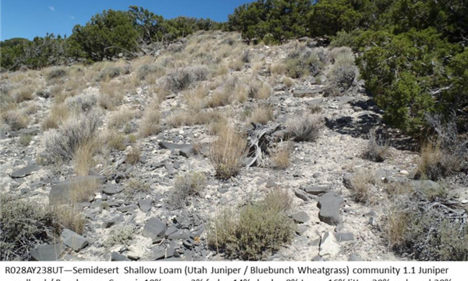
Juniper woodland/Bunchgrass
Figure 10. Phase 1.1

Figure 11. Phase 1.1 Landscape
The Juniper woodland/Bunchgrass community is characterized by scattered mature Utah junipers with an understory of bluebunch wheatgrass, black sagebrush, and other perennial grasses, shrubs, and forbs. Percent composition by air-dry weight is 30 to 65 percent grasses, 2 to 10 percent forbs, 15 to 35 percent shrubs, and 15 to 35 percent trees.
The overstory is composed of Utah juniper as the dominant woodland species with a few singleleaf or two-needle pinyon occurring on moister sites. The understory shrub layer is most commonly black sagebrush and shadscale, with yellow rabbitbrush, horsebrush, and various other shrubs occurring in different locations. Bluebunch wheatgrass is the primary component of the understory, with lesser amounts of Nevada bluegrass and Indian ricegrass commonly present. Scattered perennial forbs are diverse and species vary by location.Figure 12. Annual production by plant type (representative values) or group (midpoint values)
Table 5. Annual production by plant type
Plant type Low
(lb/acre)Representative value
(lb/acre)High
(lb/acre)Grass/Grasslike 200 300 400 Shrub/Vine 125 175 225 Tree 100 150 200 Forb 25 50 75 Total 450 675 900 Table 6. Ground cover
Tree foliar cover 10-20% Shrub/vine/liana foliar cover 10-20% Grass/grasslike foliar cover 10-20% Forb foliar cover 0-10% Non-vascular plants 0% Biological crusts 0% Litter 10-20% Surface fragments >0.25" and <=3" 0-20% Surface fragments >3" 0-30% Bedrock 0-10% Water 0% Bare ground 20-30% Table 7. Canopy structure (% cover)
Height Above Ground (ft) Tree Shrub/Vine Grass/
GrasslikeForb <0.5 0% 0% 0-5% 0-5% >0.5 <= 1 0% 0-5% 0-5% 0-5% >1 <= 2 0% 5-20% 5-15% 0-5% >2 <= 4.5 0% – – – >4.5 <= 13 5-15% – – – >13 <= 40 0-5% – – – >40 <= 80 – – – – >80 <= 120 – – – – >120 – – – – Figure 13. Plant community growth curve (percent production by month). UT2381 , PNC. Excellent Condition.
Jan Feb Mar Apr May Jun Jul Aug Sep Oct Nov Dec J F M A M J J A S O N D 0 0 5 15 40 30 5 5 0 0 0 0 Figure 14. Plant community growth curve (percent production by month). UT2382 , Good Condition NO. 1. Bluegrass, Black Sagebrush.
Jan Feb Mar Apr May Jun Jul Aug Sep Oct Nov Dec J F M A M J J A S O N D 0 0 0 20 50 20 5 5 0 0 0 0 Community 1.2
Post-fire Grassland
Figure 15. Phase 1.2

Figure 16. Phase 1.2 landscape
The Post-fire Grassland community consists of bluebunch wheatgrass and other perennial grasses, forbs, and sometimes sprouting shrubs. Percent composition by air-dry weight is 70 to 95 percent grasses, 0 to 10 percent forbs, 0 to 15 percent shrubs, and 0 to 10 percent trees.
Some mature juniper trees may survive surface fires, but most are usually killed by fire, along with non-sprouting shrubs and forbs. Bluebunch wheatgrass responds most vigorously to the burn and dominates the site for 10-30 years before shrubs begin to increase. Utah juniper may increase slowly in this community phase, but normally does not regain dominance of the overstory until about 70 years following fire (Barney and Frischknecht 1974).Figure 17. Annual production by plant type (representative values) or group (midpoint values)
Table 8. Annual production by plant type
Plant type Low
(lb/acre)Representative value
(lb/acre)High
(lb/acre)Grass/Grasslike 375 450 525 Shrub/Vine 0 50 100 Tree 0 25 65 Forb 0 25 60 Total 375 550 750 Table 9. Ground cover
Tree foliar cover 0-10% Shrub/vine/liana foliar cover 0-10% Grass/grasslike foliar cover 20-40% Forb foliar cover 0-10% Non-vascular plants 0% Biological crusts 0% Litter 10-20% Surface fragments >0.25" and <=3" 0-20% Surface fragments >3" 0-30% Bedrock 0-10% Water 0% Bare ground 20-30% Table 10. Canopy structure (% cover)
Height Above Ground (ft) Tree Shrub/Vine Grass/
GrasslikeForb <0.5 0% 0% 0-5% 0-5% >0.5 <= 1 0% 0-5% 0-5% 0-5% >1 <= 2 0% 0-5% 15-30% 0-5% >2 <= 4.5 0-5% – 0-5% – >4.5 <= 13 0-5% – – – >13 <= 40 – – – – >40 <= 80 – – – – >80 <= 120 – – – – >120 – – – – Pathway 1.1a
Community 1.1 to 1.2
Juniper woodland/Bunchgrass
Post-fire GrasslandThis pathway occurs when a crown or surface fire kills most or all of the trees and shrubs on the site. Perennial grasses respond to fire with vigorous growth and drive the ecological processes in phase 1.2 for several decades after the fire event.
Pathway 1.2a
Community 1.2 to 1.1
Post-fire Grassland
Juniper woodland/BunchgrassThis pathway occurs gradually as Utah juniper trees mature and regain dominance after about 70 years without fire. This timeframe may be affected by the pre-fire plant community and seedbank, or by fire intensity and subsequent events (such as soil erosion from unusually heavy rainfall).
Conservation practices
Firebreak Fuel Break State 2
Invaded StateThe Invaded State functions similarly to the Reference State, but allows for the presence of non-native species.
Community 2.1
Juniper woodland/Bunchgrass
Figure 18. Phase 2.1
The Juniper woodland/Bunchgrass community is characterized by scattered mature Utah junipers with an understory of bluebunch wheatgrass, black sagebrush, and other perennial grasses, shrubs, and forbs. Invasive species, including cheatgrass, storksbill, Halogeton, Russian thistle, and others are present but not dominant. Percent composition by air-dry weight is 30 to 65 percent grasses, 2 to 10 percent forbs, 15 to 35 percent shrubs, and 15 to 35 percent trees.
The overstory is composed of Utah juniper as the dominant woodland species with a few singleleaf or two needle pinyon occurring on moister sites. The understory shrub layer is most commonly black sagebrush and shadscale, with yellow rabbitbrush, horsebrush, and various other shrubs occurring in some locations. Bluebunch wheatgrass is the primary component of the understory, with lesser amounts of Nevada bluegrass and Indian ricegrass commonly present. Scattered perennial forbs are diverse and species vary by location.Figure 19. Annual production by plant type (representative values) or group (midpoint values)
Table 11. Annual production by plant type
Plant type Low
(lb/acre)Representative value
(lb/acre)High
(lb/acre)Grass/Grasslike 200 300 400 Shrub/Vine 125 175 225 Tree 100 150 200 Forb 25 50 75 Total 450 675 900 Table 12. Ground cover
Tree foliar cover 10-20% Shrub/vine/liana foliar cover 10-20% Grass/grasslike foliar cover 10-20% Forb foliar cover 0-10% Non-vascular plants 0% Biological crusts 0% Litter 10-20% Surface fragments >0.25" and <=3" 0-20% Surface fragments >3" 0-30% Bedrock 0-10% Water 0% Bare ground 20-30% Table 13. Canopy structure (% cover)
Height Above Ground (ft) Tree Shrub/Vine Grass/
GrasslikeForb <0.5 0% 0% 0-5% 0-5% >0.5 <= 1 0% 0-5% 0-5% 0-5% >1 <= 2 0% 5-20% 5-15% 0-5% >2 <= 4.5 0% – – – >4.5 <= 13 5-15% – – – >13 <= 40 0-5% – – – >40 <= 80 – – – – >80 <= 120 – – – – >120 – – – – Figure 20. Plant community growth curve (percent production by month). UT2381 , PNC. Excellent Condition.
Jan Feb Mar Apr May Jun Jul Aug Sep Oct Nov Dec J F M A M J J A S O N D 0 0 5 15 40 30 5 5 0 0 0 0 Figure 21. Plant community growth curve (percent production by month). UT2382 , Good Condition NO. 1. Bluegrass, Black Sagebrush.
Jan Feb Mar Apr May Jun Jul Aug Sep Oct Nov Dec J F M A M J J A S O N D 0 0 0 20 50 20 5 5 0 0 0 0 Community 2.2
Post-fire Grassland
Figure 22. Phase 2.2
The Post-fireGrassland community consists of bluebunch wheatgrass and other perennial grasses, forbs, and sometimes sprouting shrubs. Percent composition by air-dry weight is 70 to 95 percent grasses, 0 to 10 percent forbs, 0 to 15 percent shrubs, and 0 to 10 percent trees. Invasive species are present but not dominant.
Some mature juniper trees may survive surface fires, but most are usually killed by fire, along with non-sprouting shrubs and forbs. Bluebunch wheatgrass responds most vigorously to the burn and dominates the site for 10 to 30 years before shrubs begin to increase. Utah juniper may increase slowly in this community phase, but normally does not regain dominance of the overstory until about 70 years following fire (Barney and Frischknecht 1974).Figure 23. Annual production by plant type (representative values) or group (midpoint values)
Table 14. Annual production by plant type
Plant type Low
(lb/acre)Representative value
(lb/acre)High
(lb/acre)Grass/Grasslike 375 450 525 Shrub/Vine 0 50 100 Tree 0 25 65 Forb 0 25 60 Total 375 550 750 Table 15. Ground cover
Tree foliar cover 0-10% Shrub/vine/liana foliar cover 0-10% Grass/grasslike foliar cover 20-40% Forb foliar cover 0-10% Non-vascular plants 0% Biological crusts 0% Litter 10-20% Surface fragments >0.25" and <=3" 0-20% Surface fragments >3" 0-30% Bedrock 0-10% Water 0% Bare ground 20-30% Table 16. Canopy structure (% cover)
Height Above Ground (ft) Tree Shrub/Vine Grass/
GrasslikeForb <0.5 0% 0% 0-5% 0-5% >0.5 <= 1 0% 0-5% 0-5% 0-5% >1 <= 2 0% 0-5% 15-30% 0-5% >2 <= 4.5 0-5% – 0-5% – >4.5 <= 13 0-5% – – – >13 <= 40 – – – – >40 <= 80 – – – – >80 <= 120 – – – – >120 – – – – Community 2.3
At-risk, Increasing Invasives
Figure 24. Phase 2.3 At-Risk
This community phase is characterized by the co-dominance of invasive annual species with perennial grasses in the understory. It is at-risk of transitioning to States 3 and 4, which are dominated by invasive annuals. When perennial grass vigor is reduced, resources become available for invasive annual species. The presence of invasive species in the plant community provides a seed source, and invasive species increase to the point that the plant community becomes at-risk of losing the perennial grasses. Reduced perennial grass vigor is often the result of improper grazing and/or disturbance (such as fire, mechanical treatment, etc).
Figure 25. Annual production by plant type (representative values) or group (midpoint values)
Table 17. Annual production by plant type
Plant type Low
(lb/acre)Representative value
(lb/acre)High
(lb/acre)Grass/Grasslike 200 300 400 Shrub/Vine 125 175 225 Tree 100 150 200 Forb 25 50 75 Total 450 675 900 Table 18. Ground cover
Tree foliar cover 10-20% Shrub/vine/liana foliar cover 10-20% Grass/grasslike foliar cover 10-20% Forb foliar cover 0-10% Non-vascular plants 0% Biological crusts 0% Litter 10-20% Surface fragments >0.25" and <=3" 0-20% Surface fragments >3" 0-30% Bedrock 0-10% Water 0% Bare ground 20-30% Table 19. Canopy structure (% cover)
Height Above Ground (ft) Tree Shrub/Vine Grass/
GrasslikeForb <0.5 0% 0% 0-5% 0-5% >0.5 <= 1 0% 0-5% 0-5% 0-5% >1 <= 2 0% 5-20% 5-15% 0-5% >2 <= 4.5 0% – – – >4.5 <= 13 5-15% – – – >13 <= 40 0-5% – – – >40 <= 80 – – – – >80 <= 120 – – – – >120 – – – – Pathway 2.1a
Community 2.1 to 2.2
Juniper woodland/Bunchgrass
Post-fire GrasslandThis pathway occurs when a crown or surface fire kills most or all of the trees and shrubs on the site. Perennial grasses respond to fire with vigorous growth and drive the ecological processes in phase 1.2 for several decades after the fire event. Mechanical or chemical removal of shrubs and trees are not documented for this site. However, they are not expected to result in vigorous growth of perennial grasses as compared to fire. Mechanical and chemical removal of woody species leaves many nutrients tied up in woody debris, and may cause a different response in the plant community than fire. An increase in invasive species often occurs with disturbance in the invaded state due to the presence of invasive species seed in the seedbank that take advantage of resources made available by disturbance.
Conservation practices
Brush Management Prescribed Burning Grazing Land Mechanical Treatment Pathway 2.1b
Community 2.1 to 2.3
Juniper woodland/Bunchgrass
At-risk, Increasing InvasivesThis pathway occurs when invasive annual species increase due to the reduction in vigor of perennial grasses. Improper grazing and/or disturbance (fire, mechanical treatments, etc.) drive this community pathway.
Pathway 2.2a
Community 2.2 to 2.1
Post-fire Grassland
Juniper woodland/BunchgrassThis pathway occurs gradually as Utah juniper trees mature and regain dominance after about 70 years without fire. This timeframe may be affected by the pre-fire plant community and seedbank, or by fire intensity and subsequent events (such as soil erosion from unusually heavy rainfall).
Conservation practices
Firebreak Fuel Break Pathway 2.2b
Community 2.2 to 2.3
Post-fire Grassland
At-risk, Increasing InvasivesThis pathway occurs when invasive annual species increase due to the reduction in vigor of perennial grasses. Shrubs and Utah juniper also increase. Improper grazing and/or disturbance (excluding fire) drive this community pathway.
State 3
Utah Juniper/Annual UnderstoryThe Utah Juniper/Annual Understory state retains juniper dominance in the overstory, but is dominated by invasive annual species in the understory. Production is greatly reduced and limited to a few weeks in April and early May. This state is not resistant or resilient against further degradation to State 4, in which the juniper overstory is lost.
Community 3.1
Invasive-dominant UnderstoryThis community phase is characterized by the dominance of invasive annual species in the understory and Utah juniper in the overstory. It is at-risk of transitioning to State 4, which is dominated by invasive annuals without a juniper overstory.
Composition by air-dry weight is 0 to 10 percent perennial grasses, 30 to 40 percent annual grasses, 10 to 20 percent forbs, 15 to 30 percent shrubs, and 15 to 40 percent Utah juniper.Figure 26. Annual production by plant type (representative values) or group (midpoint values)
Table 20. Annual production by plant type
Plant type Low
(lb/acre)Representative value
(lb/acre)High
(lb/acre)Grass/Grasslike 100 200 300 Tree 100 150 200 Shrub/Vine 75 125 175 Forb 50 75 100 Total 325 550 775 Table 21. Ground cover
Tree foliar cover 10-20% Shrub/vine/liana foliar cover 0-10% Grass/grasslike foliar cover 10-30% Forb foliar cover 0-20% Non-vascular plants 0% Biological crusts 0% Litter 20-30% Surface fragments >0.25" and <=3" 0-20% Surface fragments >3" 0-30% Bedrock 0-10% Water 0% Bare ground 10-20% Table 22. Canopy structure (% cover)
Height Above Ground (ft) Tree Shrub/Vine Grass/
GrasslikeForb <0.5 0% 0% 5-15% 5-15% >0.5 <= 1 0% 0-5% 10-20% 5-15% >1 <= 2 0% 0-10% 0-5% 0-5% >2 <= 4.5 0% – – – >4.5 <= 13 5-15% – – – >13 <= 40 0-5% – – – >40 <= 80 – – – – >80 <= 120 – – – – >120 – – – – State 4
Annual DominanceThe Annual Dominance state is dominated by invasive annuals, primarily cheatgrass, which increases the fire frequency to every several years (as opposed to decades or centuries). The fire frequency precludes woody species from regaining dominance on the site, and the resource pulses favor annual species. There is currently no transition or restoration pathway out of this state.
Community 4.1
Invasive-dominant Understory
Figure 27. Phase 4.1
This community phase is characterized by the dominance of invasive annual species in the understory and the general lack of native woody and herbaceous species. Total production is greatly reduced due to the loss of all functional/structural groups besides annual grasses and forbs. Composition by air-dry weight is 0 to 10 percent perennial grasses, 60 to 85 percent annual grasses, 10 to 25 percent forbs, 0 to 10 percent shrubs, and 0 to 5 percent Utah juniper.
Figure 28. Annual production by plant type (representative values) or group (midpoint values)
Table 23. Annual production by plant type
Plant type Low
(lb/acre)Representative value
(lb/acre)High
(lb/acre)Grass/Grasslike 100 250 450 Shrub/Vine 5 50 100 Forb 50 75 100 Tree 0 20 40 Total 155 395 690 Table 24. Ground cover
Tree foliar cover 0-0% Shrub/vine/liana foliar cover 0-10% Grass/grasslike foliar cover 20-40% Forb foliar cover 0-30% Non-vascular plants 0% Biological crusts 0% Litter 20-30% Surface fragments >0.25" and <=3" 0-20% Surface fragments >3" 0-30% Bedrock 0-10% Water 0% Bare ground 10-30% Table 25. Canopy structure (% cover)
Height Above Ground (ft) Tree Shrub/Vine Grass/
GrasslikeForb <0.5 0% 0% 5-15% 5-20% >0.5 <= 1 0% 0-5% 15-30% 5-20% >1 <= 2 0% 0-5% 0-5% 0-5% >2 <= 4.5 0% – – – >4.5 <= 13 0-2% – – – >13 <= 40 0-2% – – – >40 <= 80 – – – – >80 <= 120 – – – – >120 – – – – Transition T1a
State 1 to 2This transition occurs when invasive species establish on the site. Establishment of invasive species provides a seed source that decreases the resilience of the site following natural or human disturbance.
Transition T2a
State 2 to 3This transition occurs when invasive annual species, such as cheatgrass and storksbill, become dominant in the understory, while Utah juniper remains dominant in the overstory. Some perennial grasses may be present but not dominant. Improper grazing that further reduces the vigor of perennial grasses during the growing season can drive this transition.
Transition T2b
State 2 to 4This transition occurs when fire or other disturbance removes the woody species and frees up resources for invasive annuals, such as cheatgrass and storksbill. Invasive annuals now dominate the site and drive the ecological processes in their own favor, and to the exclusion of native species. Perennial grasses may be present but not dominant. The fire return interval is expected to be reduced to every few years, instead of several decades or centuries.
Transition T3a
State 3 to 4This transition occurs when fire or other disturbance removes woody species and frees up resources for invasive annual species to thrive. Juniper and other woody species are not able to regain dominance in the community due to increased fire frequency following this transition.
Additional community tables
Table 26. Community 1.1 plant community composition
Group Common name Symbol Scientific name Annual production () Foliar cover (%) Tree0 Trees 100–200 Utah juniper JUOS Juniperus osteosperma 100–200 5–15 twoneedle pinyon PIED Pinus edulis 0–20 0–1 singleleaf pinyon PIMO Pinus monophylla 0–20 0–1 Shrub/Vine0 Shrubs 125–225 black sagebrush ARNO4 Artemisia nova 50–125 5–15 shadscale saltbush ATCO Atriplex confertifolia 5–50 0–3 yellow rabbitbrush CHVI8 Chrysothamnus viscidiflorus 5–50 0–3 shortspine horsebrush TESP2 Tetradymia spinosa 0–50 0–3 rubber rabbitbrush ERNA10 Ericameria nauseosa 0–30 0–2 broom snakeweed GUSA2 Gutierrezia sarothrae 0–30 0–2 plains pricklypear OPPO Opuntia polyacantha 0–30 0–2 spineless horsebrush TECA2 Tetradymia canescens 0–30 0–2 Grass/Grasslike0 Primary Grasses 180–400 bluebunch wheatgrass PSSP6 Pseudoroegneria spicata 160–360 8–15 Indian ricegrass ACHY Achnatherum hymenoides 10–50 1–3 Sandberg bluegrass POSE Poa secunda 10–50 1–3 1 Secondary Grasses 0–35 purple threeawn ARPU9 Aristida purpurea 0–20 0–2 blue grama BOGR2 Bouteloua gracilis 0–20 0–2 squirreltail ELEL5 Elymus elymoides 0–20 0–2 needle and thread HECO26 Hesperostipa comata 0–20 0–2 western wheatgrass PASM Pascopyrum smithii 0–20 0–2 James' galleta PLJA Pleuraphis jamesii 0–20 0–2 basin wildrye LECI4 Leymus cinereus 0–10 0–1 Forb2 Forbs 25–75 desert princesplume STPI Stanleya pinnata 0–35 0–3 aster ASTER Aster 0–20 0–2 Hooker's balsamroot BAHO Balsamorhiza hookeri 0–20 0–2 cryptantha CRYPT Cryptantha 0–20 0–2 fleabane ERIGE2 Erigeron 0–20 0–2 cushion buckwheat EROV Eriogonum ovalifolium 0–20 0–2 ballhead ipomopsis IPCOC3 Ipomopsis congesta ssp. congesta 0–20 0–2 Chambers' twinpod PHCH2 Physaria chambersii 0–20 0–2 spiny phlox PHHO Phlox hoodii 0–20 0–2 gooseberryleaf globemallow SPGR2 Sphaeralcea grossulariifolia 0–20 0–2 browse milkvetch ASCI2 Astragalus cibarius 0–15 0–2 Table 27. Community 1.2 plant community composition
Group Common name Symbol Scientific name Annual production () Foliar cover (%) Tree0 Trees 0–65 Utah juniper JUOS Juniperus osteosperma 0–65 0–4 twoneedle pinyon PIED Pinus edulis 0–10 0–1 singleleaf pinyon PIMO Pinus monophylla 0–10 0–1 Shrub/Vine0 Shrubs 0–100 broom snakeweed GUSA2 Gutierrezia sarothrae 0–50 0–4 yellow rabbitbrush CHVI8 Chrysothamnus viscidiflorus 0–50 0–3 black sagebrush ARNO4 Artemisia nova 0–50 0–3 shortspine horsebrush TESP2 Tetradymia spinosa 0–50 0–3 shadscale saltbush ATCO Atriplex confertifolia 0–30 0–2 rubber rabbitbrush ERNA10 Ericameria nauseosa 0–30 0–2 plains pricklypear OPPO Opuntia polyacantha 0–30 0–2 spineless horsebrush TECA2 Tetradymia canescens 0–30 0–2 Grass/Grasslike0 Primary Grasses 375–525 bluebunch wheatgrass PSSP6 Pseudoroegneria spicata 300–500 15–20 Indian ricegrass ACHY Achnatherum hymenoides 10–75 1–5 Sandberg bluegrass POSE Poa secunda 10–75 1–5 1 Secondary Grasses 0–75 purple threeawn ARPU9 Aristida purpurea 0–40 0–2 blue grama BOGR2 Bouteloua gracilis 0–40 0–2 James' galleta PLJA Pleuraphis jamesii 0–40 0–2 western wheatgrass PASM Pascopyrum smithii 0–30 0–2 squirreltail ELEL5 Elymus elymoides 0–30 0–2 needle and thread HECO26 Hesperostipa comata 0–30 0–2 basin wildrye LECI4 Leymus cinereus 0–10 0–1 Forb2 Forbs 0–60 desert princesplume STPI Stanleya pinnata 0–35 0–3 aster ASTER Aster 0–20 0–2 Hooker's balsamroot BAHO Balsamorhiza hookeri 0–20 0–2 cryptantha CRYPT Cryptantha 0–20 0–2 fleabane ERIGE2 Erigeron 0–20 0–2 cushion buckwheat EROV Eriogonum ovalifolium 0–20 0–2 ballhead ipomopsis IPCOC3 Ipomopsis congesta ssp. congesta 0–20 0–2 Chambers' twinpod PHCH2 Physaria chambersii 0–20 0–2 spiny phlox PHHO Phlox hoodii 0–20 0–2 gooseberryleaf globemallow SPGR2 Sphaeralcea grossulariifolia 0–20 0–2 browse milkvetch ASCI2 Astragalus cibarius 0–15 0–2 Table 28. Community 2.1 plant community composition
Group Common name Symbol Scientific name Annual production () Foliar cover (%) Tree0 Trees 100–200 Utah juniper JUOS Juniperus osteosperma 100–200 5–15 twoneedle pinyon PIED Pinus edulis 0–20 0–1 singleleaf pinyon PIMO Pinus monophylla 0–20 0–1 Shrub/Vine0 Shrubs 125–225 black sagebrush ARNO4 Artemisia nova 50–125 5–15 shadscale saltbush ATCO Atriplex confertifolia 5–50 0–3 yellow rabbitbrush CHVI8 Chrysothamnus viscidiflorus 5–50 0–3 shortspine horsebrush TESP2 Tetradymia spinosa 0–50 0–3 rubber rabbitbrush ERNA10 Ericameria nauseosa 0–30 0–2 broom snakeweed GUSA2 Gutierrezia sarothrae 0–30 0–2 plains pricklypear OPPO Opuntia polyacantha 0–30 0–2 spineless horsebrush TECA2 Tetradymia canescens 0–30 0–2 Grass/Grasslike0 Primary Grasses 180–400 bluebunch wheatgrass PSSP6 Pseudoroegneria spicata 160–360 8–15 Indian ricegrass ACHY Achnatherum hymenoides 10–50 1–3 Sandberg bluegrass POSE Poa secunda 10–50 1–3 cheatgrass BRTE Bromus tectorum 1–25 0–2 1 Secondary Grasses 0–35 western wheatgrass PASM Pascopyrum smithii 0–20 0–2 James' galleta PLJA Pleuraphis jamesii 0–20 0–2 purple threeawn ARPU9 Aristida purpurea 0–20 0–2 blue grama BOGR2 Bouteloua gracilis 0–20 0–2 squirreltail ELEL5 Elymus elymoides 0–20 0–2 needle and thread HECO26 Hesperostipa comata 0–20 0–2 basin wildrye LECI4 Leymus cinereus 0–10 0–1 Forb2 Forbs 25–75 desert princesplume STPI Stanleya pinnata 0–35 0–3 Russian thistle SAKA Salsola kali 0–25 0–2 tall tumblemustard SIAL2 Sisymbrium altissimum 0–25 0–2 redstem stork's bill ERCI6 Erodium cicutarium 0–25 0–2 saltlover HAGL Halogeton glomeratus 0–25 0–2 ballhead ipomopsis IPCOC3 Ipomopsis congesta ssp. congesta 0–20 0–2 Chambers' twinpod PHCH2 Physaria chambersii 0–20 0–2 spiny phlox PHHO Phlox hoodii 0–20 0–2 fleabane ERIGE2 Erigeron 0–20 0–2 cushion buckwheat EROV Eriogonum ovalifolium 0–20 0–2 aster ASTER Aster 0–20 0–2 Hooker's balsamroot BAHO Balsamorhiza hookeri 0–20 0–2 cryptantha CRYPT Cryptantha 0–20 0–2 gooseberryleaf globemallow SPGR2 Sphaeralcea grossulariifolia 0–20 0–2 browse milkvetch ASCI2 Astragalus cibarius 0–15 0–2 Table 29. Community 2.2 plant community composition
Group Common name Symbol Scientific name Annual production () Foliar cover (%) Tree0 Trees 0–65 Utah juniper JUOS Juniperus osteosperma 0–65 0–4 twoneedle pinyon PIED Pinus edulis 0–10 0–1 singleleaf pinyon PIMO Pinus monophylla 0–10 0–1 Shrub/Vine0 Shrubs 0–100 broom snakeweed GUSA2 Gutierrezia sarothrae 0–50 0–4 shortspine horsebrush TESP2 Tetradymia spinosa 0–50 0–3 black sagebrush ARNO4 Artemisia nova 0–50 0–3 yellow rabbitbrush CHVI8 Chrysothamnus viscidiflorus 0–50 0–3 rubber rabbitbrush ERNA10 Ericameria nauseosa 0–30 0–2 shadscale saltbush ATCO Atriplex confertifolia 0–30 0–2 plains pricklypear OPPO Opuntia polyacantha 0–30 0–2 spineless horsebrush TECA2 Tetradymia canescens 0–30 0–2 Grass/Grasslike0 Primary Grasses 375–525 bluebunch wheatgrass PSSP6 Pseudoroegneria spicata 300–500 15–20 Indian ricegrass ACHY Achnatherum hymenoides 10–75 1–5 Sandberg bluegrass POSE Poa secunda 10–75 1–5 cheatgrass BRTE Bromus tectorum 1–50 0–3 1 Secondary Grasses 0–75 James' galleta PLJA Pleuraphis jamesii 0–40 0–2 purple threeawn ARPU9 Aristida purpurea 0–40 0–2 blue grama BOGR2 Bouteloua gracilis 0–40 0–2 squirreltail ELEL5 Elymus elymoides 0–30 0–2 needle and thread HECO26 Hesperostipa comata 0–30 0–2 western wheatgrass PASM Pascopyrum smithii 0–30 0–2 basin wildrye LECI4 Leymus cinereus 0–10 0–1 Forb2 Forbs 0–60 redstem stork's bill ERCI6 Erodium cicutarium 0–50 0–4 desert princesplume STPI Stanleya pinnata 0–35 0–3 Russian thistle SAKA Salsola kali 0–25 0–2 tall tumblemustard SIAL2 Sisymbrium altissimum 0–25 0–2 saltlover HAGL Halogeton glomeratus 0–25 0–2 ballhead ipomopsis IPCOC3 Ipomopsis congesta ssp. congesta 0–20 0–2 Chambers' twinpod PHCH2 Physaria chambersii 0–20 0–2 spiny phlox PHHO Phlox hoodii 0–20 0–2 fleabane ERIGE2 Erigeron 0–20 0–2 cushion buckwheat EROV Eriogonum ovalifolium 0–20 0–2 aster ASTER Aster 0–20 0–2 Hooker's balsamroot BAHO Balsamorhiza hookeri 0–20 0–2 cryptantha CRYPT Cryptantha 0–20 0–2 gooseberryleaf globemallow SPGR2 Sphaeralcea grossulariifolia 0–20 0–2 browse milkvetch ASCI2 Astragalus cibarius 0–15 0–2 Table 30. Community 2.3 plant community composition
Group Common name Symbol Scientific name Annual production () Foliar cover (%) Tree0 Trees 100–200 Utah juniper JUOS Juniperus osteosperma 100–200 5–15 twoneedle pinyon PIED Pinus edulis 0–20 0–1 singleleaf pinyon PIMO Pinus monophylla 0–20 0–1 Shrub/Vine0 Shrubs 125–225 black sagebrush ARNO4 Artemisia nova 50–125 5–15 shadscale saltbush ATCO Atriplex confertifolia 5–50 0–3 yellow rabbitbrush CHVI8 Chrysothamnus viscidiflorus 5–50 0–3 shortspine horsebrush TESP2 Tetradymia spinosa 0–50 0–3 rubber rabbitbrush ERNA10 Ericameria nauseosa 0–30 0–2 broom snakeweed GUSA2 Gutierrezia sarothrae 0–30 0–2 plains pricklypear OPPO Opuntia polyacantha 0–30 0–2 spineless horsebrush TECA2 Tetradymia canescens 0–30 0–2 Grass/Grasslike0 Primary Grasses 180–400 bluebunch wheatgrass PSSP6 Pseudoroegneria spicata 80–180 4–8 cheatgrass BRTE Bromus tectorum 80–180 0–2 Sandberg bluegrass POSE Poa secunda 10–50 1–3 Indian ricegrass ACHY Achnatherum hymenoides 10–50 1–3 1 Secondary Grasses 0–35 western wheatgrass PASM Pascopyrum smithii 0–20 0–2 James' galleta PLJA Pleuraphis jamesii 0–20 0–2 purple threeawn ARPU9 Aristida purpurea 0–20 0–2 blue grama BOGR2 Bouteloua gracilis 0–20 0–2 squirreltail ELEL5 Elymus elymoides 0–20 0–2 needle and thread HECO26 Hesperostipa comata 0–20 0–2 basin wildrye LECI4 Leymus cinereus 0–10 0–1 Forb2 Forbs 25–75 desert princesplume STPI Stanleya pinnata 0–35 0–3 Russian thistle SAKA Salsola kali 0–25 0–2 tall tumblemustard SIAL2 Sisymbrium altissimum 0–25 0–2 redstem stork's bill ERCI6 Erodium cicutarium 0–25 0–2 saltlover HAGL Halogeton glomeratus 0–25 0–2 ballhead ipomopsis IPCOC3 Ipomopsis congesta ssp. congesta 0–20 0–2 Chambers' twinpod PHCH2 Physaria chambersii 0–20 0–2 spiny phlox PHHO Phlox hoodii 0–20 0–2 fleabane ERIGE2 Erigeron 0–20 0–2 cushion buckwheat EROV Eriogonum ovalifolium 0–20 0–2 aster ASTER Aster 0–20 0–2 Hooker's balsamroot BAHO Balsamorhiza hookeri 0–20 0–2 cryptantha CRYPT Cryptantha 0–20 0–2 gooseberryleaf globemallow SPGR2 Sphaeralcea grossulariifolia 0–20 0–2 browse milkvetch ASCI2 Astragalus cibarius 0–15 0–2 Table 31. Community 3.1 plant community composition
Group Common name Symbol Scientific name Annual production () Foliar cover (%) Tree0 Trees 100–200 Utah juniper JUOS Juniperus osteosperma 100–200 5–15 twoneedle pinyon PIED Pinus edulis 0–20 0–1 singleleaf pinyon PIMO Pinus monophylla 0–20 0–1 Shrub/Vine0 Shrubs 75–175 black sagebrush ARNO4 Artemisia nova 50–125 5–15 shadscale saltbush ATCO Atriplex confertifolia 5–50 0–3 yellow rabbitbrush CHVI8 Chrysothamnus viscidiflorus 5–50 0–3 shortspine horsebrush TESP2 Tetradymia spinosa 0–50 0–3 rubber rabbitbrush ERNA10 Ericameria nauseosa 0–30 0–2 broom snakeweed GUSA2 Gutierrezia sarothrae 0–30 0–2 plains pricklypear OPPO Opuntia polyacantha 0–30 0–2 spineless horsebrush TECA2 Tetradymia canescens 0–30 0–2 Grass/Grasslike0 Primary Grasses 100–300 cheatgrass BRTE Bromus tectorum 90–290 5–25 Sandberg bluegrass POSE Poa secunda 10–50 1–3 1 Secondary Grasses 0–25 bluebunch wheatgrass PSSP6 Pseudoroegneria spicata 0–25 0–2 James' galleta PLJA Pleuraphis jamesii 0–20 0–2 purple threeawn ARPU9 Aristida purpurea 0–20 0–2 blue grama BOGR2 Bouteloua gracilis 0–20 0–2 squirreltail ELEL5 Elymus elymoides 0–10 0–1 needle and thread HECO26 Hesperostipa comata 0–10 0–1 basin wildrye LECI4 Leymus cinereus 0–10 0–1 Indian ricegrass ACHY Achnatherum hymenoides 0–10 0–1 western wheatgrass PASM Pascopyrum smithii 0–1 0–1 Forb2 Forbs 50–100 redstem stork's bill ERCI6 Erodium cicutarium 0–100 0–8 Russian thistle SAKA Salsola kali 0–75 0–6 tall tumblemustard SIAL2 Sisymbrium altissimum 0–50 0–4 saltlover HAGL Halogeton glomeratus 0–50 0–4 desert princesplume STPI Stanleya pinnata 0–35 0–3 gooseberryleaf globemallow SPGR2 Sphaeralcea grossulariifolia 0–20 0–2 ballhead ipomopsis IPCOC3 Ipomopsis congesta ssp. congesta 0–20 0–2 Chambers' twinpod PHCH2 Physaria chambersii 0–20 0–2 spiny phlox PHHO Phlox hoodii 0–20 0–2 fleabane ERIGE2 Erigeron 0–20 0–2 cushion buckwheat EROV Eriogonum ovalifolium 0–20 0–2 aster ASTER Aster 0–20 0–2 Hooker's balsamroot BAHO Balsamorhiza hookeri 0–20 0–2 cryptantha CRYPT Cryptantha 0–20 0–2 browse milkvetch ASCI2 Astragalus cibarius 0–15 0–2 Table 32. Community 4.1 plant community composition
Group Common name Symbol Scientific name Annual production () Foliar cover (%) Tree0 Trees 0–40 Utah juniper JUOS Juniperus osteosperma 0–40 0–2 twoneedle pinyon PIED Pinus edulis 0–10 0–1 singleleaf pinyon PIMO Pinus monophylla 0–10 0–1 Shrub/Vine0 Shrubs 5–100 yellow rabbitbrush CHVI8 Chrysothamnus viscidiflorus 0–100 0–8 rubber rabbitbrush ERNA10 Ericameria nauseosa 0–100 0–8 broom snakeweed GUSA2 Gutierrezia sarothrae 0–100 0–8 shortspine horsebrush TESP2 Tetradymia spinosa 0–75 0–5 plains pricklypear OPPO Opuntia polyacantha 0–50 0–4 spineless horsebrush TECA2 Tetradymia canescens 0–50 0–4 black sagebrush ARNO4 Artemisia nova 0–10 0–1 shadscale saltbush ATCO Atriplex confertifolia 0–10 0–1 Grass/Grasslike0 Primary Grasses 100–400 cheatgrass BRTE Bromus tectorum 100–400 10–30 1 Secondary Grasses 0–50 Sandberg bluegrass POSE Poa secunda 0–40 0–3 bluebunch wheatgrass PSSP6 Pseudoroegneria spicata 0–25 0–2 purple threeawn ARPU9 Aristida purpurea 0–20 0–2 blue grama BOGR2 Bouteloua gracilis 0–20 0–2 James' galleta PLJA Pleuraphis jamesii 0–20 0–2 squirreltail ELEL5 Elymus elymoides 0–10 0–1 needle and thread HECO26 Hesperostipa comata 0–10 0–1 basin wildrye LECI4 Leymus cinereus 0–10 0–1 Indian ricegrass ACHY Achnatherum hymenoides 0–10 0–1 western wheatgrass PASM Pascopyrum smithii 0–1 0–1 Forb2 Forbs 50–100 redstem stork's bill ERCI6 Erodium cicutarium 0–100 0–8 Russian thistle SAKA Salsola kali 0–75 0–6 tall tumblemustard SIAL2 Sisymbrium altissimum 0–75 0–6 saltlover HAGL Halogeton glomeratus 0–50 0–4 gooseberryleaf globemallow SPGR2 Sphaeralcea grossulariifolia 0–20 0–2 desert princesplume STPI Stanleya pinnata 0–10 0–1 fleabane ERIGE2 Erigeron 0–10 0–1 cushion buckwheat EROV Eriogonum ovalifolium 0–10 0–1 ballhead ipomopsis IPCOC3 Ipomopsis congesta ssp. congesta 0–10 0–1 Chambers' twinpod PHCH2 Physaria chambersii 0–10 0–1 spiny phlox PHHO Phlox hoodii 0–10 0–1 browse milkvetch ASCI2 Astragalus cibarius 0–10 0–1 aster ASTER Aster 0–10 0–1 Hooker's balsamroot BAHO Balsamorhiza hookeri 0–10 0–1 cryptantha CRYPT Cryptantha 0–10 0–1 Interpretations
Animal community
Approximately 40 percent of the plants furnish some forage for livestock. Limited numbers of plant species occur, but they have enough variety to provide balanced nutrition for cattle, horses, and sheep. Grazing can be during all seasons, but best efficiency is in the fall or winter. Spring grazing is a common practice.
Wildlife using this site include antelope, blacktailed jackrabbit, coyote, morning dove, golden eagles (fall and spring), a few songbirds, and a few species of small mammals.
This is a short list of the more common species found. Many other species are present as well and migratory birds are present at times.Hydrological functions
The soil series is in hydrologic group D. The hydrologic curve number is 80 when the vegetation is in good condition.
Recreational uses
Values are fair for camping, hiking, and picnicking.
Wood products
The Semidesert Shallow Loam (Utah Juniper-Bluebunch Wheatgrass) North site yields approximately three cords of juniper per acre for firewood.
Other information
Threatened and endangered species include plants and animals.
Supporting information
Type locality
Location 1: Box Elder County, UT General legal description Warm Springs Hill 15 Miles west of Park Valley Other references
Barney, Milo A.; Frischknecht, Neil C. 1974. Vegetation changes following fire in the pinyon-juniper type of west-central Utah. Journal of Range Management. 27(2): 91-96. [397]
Contributors
GR DJS
GR, David J. Somerville
Jamin JohansonApproval
Jamin Johanson, 5/02/2025
Rangeland health reference sheet
Interpreting Indicators of Rangeland Health is a qualitative assessment protocol used to determine ecosystem condition based on benchmark characteristics described in the Reference Sheet. A suite of 17 (or more) indicators are typically considered in an assessment. The ecological site(s) representative of an assessment location must be known prior to applying the protocol and must be verified based on soils and climate. Current plant community cannot be used to identify the ecological site.
Author(s)/participant(s) Jack Alexander, Range Specialist, Synergy Resource Solutions, Inc. Julia Kluck, Soil Scientist, Synergy Resource Solutions, Inc. Shane Green, State Range Specialist, Utah NRCS Contact for lead author Shane Green, Shane.Green@ut.usda.gov Date 02/09/2010 Approved by Approval date Composition (Indicators 10 and 12) based on Annual Production Indicators
-
Number and extent of rills:
Some rills present. Rill development may increase following large storm events, but should begin to heal during the following growing season. Frost heaving will accelerate recovery. Rill development may increase when run inflow enters site from other sites that produce large amounts of runoff (i.e. steeper sites, slickrock, rock outcrop). -
Presence of water flow patterns:
Water flow patterns will be short (2-5’) and meandering; interrupted by plants and exposed rocks. Some evidence of erosion or deposition associated with flow patterns. Where slopes exceed 5%, water flow patterns may be longer (5–10’). -
Number and height of erosional pedestals or terracettes:
Plants may have small pedestals (1-3”) where they are adjacent to water flow patterns, but without exposed roots. Terracettes should be few and stable. Terracettes should be small (1-3”) and show little sign of active erosion. Some plants may appear to have a pedestal but rather than be formed by erosion, the only place litter accumulates and soil collects is at plant bases forming the appearance of a pedestal. Well-developed biological crusts may appear pedestalled, but are actually a characteristic of the crust formation. Some plants may appear to have a pedestal but rather than be formed by erosion, the only place litter accumulates and soil collects is at plant bases forming the appearance of a pedestal. -
Bare ground from Ecological Site Description or other studies (rock, litter, lichen, moss, plant canopy are not bare ground):
20-40% bare ground (soil with no protection from raindrop impact). Herbaceous communities are most likely to have lower values. As species composition by shrubs increases, bare ground is likely to increase. Poorly developed biological soil crust that is susceptible to raindrop splash erosion should be recorded as bare ground. Very few if any bare spaces of greater than 1 square foot. -
Number of gullies and erosion associated with gullies:
No gullies present. -
Extent of wind scoured, blowouts and/or depositional areas:
Very minor evidence of active wind-generated soil movement. Wind scoured (blowouts) and depositional areas are rarely present. If present they have muted features and are mostly stabilized with vegetation and/or biological crust. Gravel or desert pavement protects the site from wind scour. -
Amount of litter movement (describe size and distance expected to travel):
Most litter resides in place with some redistribution caused by water and wind movement. Very minor litter removal may occur in flow patterns and rills with deposition occurring at points of obstruction. The majority of litter accumulates at the base of plants. Some leaves, stems, and small twigs may accumulate in soil depressions adjacent to plants. Woody stems are not likely to move. On steep slopes (>30%), litter will move downhill to next obstruction. -
Soil surface (top few mm) resistance to erosion (stability values are averages - most sites will show a range of values):
This site should have an erosion rating of 5 or 6 under plant canopies and a rating of 4 to 5 in the interspaces with an average rating of 5 using the soil stability kit test. -
Soil surface structure and SOM content (include type of structure and A-horizon color and thickness):
This description is based on the modal soil (Amtoft Family CBV-L, soil survey area: 611, Tooele), the only soil correlated with this site. Soil surface horizon is typically 8 inches deep. Structure is typically weak medium subungular blocky. Color is typically pale brown (10YR 6/3), brown (10YR 4/3) moist. An ochric horizon extends to a depth of 8 inches. An ochric horizon typically extends to a depth of 2 to 10 inches. The ochric horizon is a surface horizon lacking fine stratification and which is either light colored, or thin, or has an low organic carbon content, or is massive and (very) hard when dry. The A horizon would be expected to be more strongly developed under plant canopies. It is important if you are sampling to observe the A horizon under plant canopies as well as the interspaces. -
Effect of community phase composition (relative proportion of different functional groups) and spatial distribution on infiltration and runoff:
Vascular plants and any well-developed biological soil crusts (where present) will break raindrop impact and splash erosion. Spatial distribution of vascular plants and interspaces between well-developed biological soil crusts (where present) provide detention storage and surface roughness that slows runoff allowing time for infiltration. Crowns of trees and accumulating litter at base of trees appear to create a micro-topography that may enhance development of water flow patterns below the drip line of the canopy. Significant increases in pinyon-juniper canopy reduces understory vegetation and increases runoff. -
Presence and thickness of compaction layer (usually none; describe soil profile features which may be mistaken for compaction on this site):
None. Lithic contact (the boundary with hard bedrock) may occur at about 17 inches. Naturally occurring soil horizons may be harder than the surface because of an accumulation of calcium carbonate and should not be considered as compaction layers. -
Functional/Structural Groups (list in order of descending dominance by above-ground annual-production or live foliar cover using symbols: >>, >, = to indicate much greater than, greater than, and equal to):
Dominant:
Utah juniper > bluebunch wheatgrass, black sagebrushSub-dominant:
Indian ricegrass, shadscale saltbushOther:
other shrubs, other grasses, forbsAdditional:
In the northern portion of the MLRA cool-season perennial grasses (Indian ricegrass, needle and thread) dominate. In the southernmost portion of the MLRA warm-season perennial grasses (galleta, sand dropseed) dominate. The two groups share dominance in the middle portion of the MLRA. -
Amount of plant mortality and decadence (include which functional groups are expected to show mortality or decadence):
During years with average to above average precipitation, there should be very little recent mortality or decadence apparent in either the shrubs or grasses. Some bunchgrass and shrub mortality may occur during severe droughts, particularly on the shallower and coarser soils associated with this site. -
Average percent litter cover (%) and depth ( in):
Litter cover includes litter under plants. Most litter will be fine litter. Depth should be 1-2 leaf thickness in the interspaces and up to 1/2” under canopies. Litter cover may increase to 20-30% following years with favorable growing conditions. Excess litter may accumulate in absence of disturbance. Vegetative production may be reduced if litter cover exceeds 40%. -
Expected annual annual-production (this is TOTAL above-ground annual-production, not just forage annual-production):
650#/acre. Even the most stable communities exhibit a range of production values. Production will vary between communities and across the MRLA. Refer to the community descriptions in the ESD. Production will differ across the MLRA due to the naturally occurring variability in weather, soils, and aspect. The biological processes on this site are complex; therefore, representative values are presented in a land management context. -
Potential invasive (including noxious) species (native and non-native). List species which BOTH characterize degraded states and have the potential to become a dominant or co-dominant species on the ecological site if their future establishment and growth is not actively controlled by management interventions. Species that become dominant for only one to several years (e.g., short-term response to drought or wildfire) are not invasive plants. Note that unlike other indicators, we are describing what is NOT expected in the reference state for the ecological site:
Cheatgrass, halogeton, green rabbitbrush, annual forbs, broom snakeweed, Utah juniper, purple threeawn, medusahead rye. -
Perennial plant reproductive capability:
All perennial plants should have the ability to reproduce sexually or asexually, except in drought years. Density of plants indicates that plants reproduce at level sufficient to fill available resource. Within capability of site there are no restrictions on seed or vegetative reproductive capacity.
Print Options
Sections
Font
AAAAOther
PrintThe Ecosystem Dynamics Interpretive Tool is an information system framework developed by the USDA-ARS Jornada Experimental Range, USDA Natural Resources Conservation Service, and New Mexico State University.
Accessibility statement


