
Natural Resources
Conservation Service
Ecological site R028AY001UT
Alkali Bottom (Alkali Sacaton)
Last updated: 5/02/2025
Accessed: 08/28/2026
-
Search


Major Land Resource Area or ecological site by name and/or ID.
PreviousSectionsNextGeneral information
Provisional. A provisional ecological site description has undergone quality control and quality assurance review. It contains a working state and transition model and enough information to identify the ecological site.
Click to explore map
Figure 1. Mapped extent
Areas shown in blue indicate the maximum mapped extent of this ecological site. Other ecological sites likely occur within the highlighted areas. It is also possible for this ecological site to occur outside of highlighted areas if detailed soil survey has not been completed or recently updated.
MLRA notes
Major Land Resource Area (MLRA): 028A–Ancient Lake Bonneville
MLRA 28A occurs in Utah (82 percent), Nevada (16 percent), and Idaho (2 percent). It encompasses approximately 36,775 square miles (95,246 square kilometers). A large area west and southwest of Great Salt Lake is a salty playa. This area is the farthest eastern extent of the Great Basin Section of the Basin and Range Province of the Intermontane Plateaus. It is an area of nearly level basins between widely separated mountain ranges trending north to south. The basins are bordered by long, gently sloping alluvial fans. The mountains are uplifted fault blocks with steep side slopes. Most of the valleys are closed basins containing sinks or playa lakes. Elevation ranges from 3,950 to 6,560 feet (1,204 to 2000 meters) in the basins and from 6,560 to 11,150 feet (1996 to 3398 meters) in the mountains. Much of the MLRA has alluvial valley fill and playa lakebed deposits at the surface from pluvial Lake Bonneville, which dominated this MLRA 13,000 years ago. A level line of remnant lake terraces on some mountain slopes indicates the former extent of this glacial lake. The Great Salt Lake is what remains of the pluvial lake.
Mountains in the interior of this MLRA consist of tilted blocks of marine sediments from Cambrian to Mississippian age with scattered outcrops of Tertiary continental sediments and volcanic rocks. The average annual precipitation is 5 to 12 inches (13 to 30 cm) in the valleys and ranges up to 49 inches (124 cm) in the mountains. Most of the rainfall in the southern LRU occurs as high-intensity, convective thunderstorms during the growing season (April through September). The driest period is from midsummer to early autumn in the northern LRU. Precipitation in winter typically occurs as snow. The average annual temperature is 39 to 53 °F (4 to 12 °C). The freeze-free period averages 165 days and ranges from 110 to 215 days, decreasing in length with increasing elevation. The dominant soil orders in this MLRA are Aridisols, Entisols, and Mollisols. Soils are dominantly in the mesic or frigid soil temperature regime, aridic or xeric soil moisture regime, and mixed mineralogy. The soils are generally well drained, loamy or loamy-skeletal, and very deep.LRU notes
The Salt Desert/Wetland LRU consists of all the run-in ecological sites. Run-in sites occur in landform positions that receive additional moisture either through overland flow or subsurface water flow. Typical landforms are basin floors, lake plains, low lake terraces, depressional areas, drainageways, and flood plains. Sites within the Salt Desert/Wetland LRU typically have water table depths of less than 60 inches (152 cm). Wetland plants, pickleweed and/or greasewood are dominant in the plant communities.
Ecological site concept
The Alkali Bottom site is typically located on lake plains, lake terraces, valley floors, flood plains, alluvial flats, and in depressional areas within lake terraces. It typically occupies the area just above lake playas and just below the Alkali Flat ecological site. Slopes typically range from 0 to 2 percent but may occasionally reach 3 percent. This site may rarely flood during runoff periods. The water table is typically between 18 and 60 inches (46 to 152 cm).
Associated sites
R028AY024UT Wet Saline Meadow (Saltgrass)
The Wet Saline Meadow site will occur down slope from the Alkali Bottom site.
R028AY130UT Desert Salt Flat (Sickle Saltbush)
This site may occur adjacent to the Alkali Bottom site where the water table is deeper than 60 inches.
R028AY025UT Lakeshore Marsh
The Lakeshore Marsh site will occur down slope from the Alkali Bottom.
R028AY132UT Desert Salty Silt (Iodinebush)
The Desert Salty Silt site will occur down slope in the playa.
R028AY004UT Alkali Flat (Black Greasewood)
The Alkali Flat site will often occur up slope from the Alkali Bottom site.
R028AY006UT Loamy Bottom (basin wildrye)
The Loamy Bottom site may occur in areas without alkali influence and have a deeper water table.
Similar sites
R028AY004UT Alkali Flat (Black Greasewood)
The Alkali Flat site will occur on similar landforms up slope from the Alkali Bottom site however the Alkali Flat site will not have a water table within 60 inches. The Alkali Flat site will look similar to a disturbed Alkali Bottom site where the greasewood dominates both sites. Water table depth should be used to determine the site potential.
R028AY010UT Semiwet Saline Meadow
The Semi-wet Saline Meadow site has only been correlated to flood plains. The Semi-wet Saline Meadow site was developed in northern Utah, however the soils that were originally correlated to this site have been recorrelated to the Alkali Bottom site. There is currently not a reliable abiotic characteristics to separate these two sites.
R028AY024UT Wet Saline Meadow (Saltgrass)
The Wet Saline Meadow site will have a water table closer to the soil surface and will support plants that can tolerate wetter conditions.
Table 1. Dominant plant species
Tree Not specified
Shrub (1) Sarcobatus vermiculatus
Herbaceous (1) Sporobolus airoides
(2) Distichlis spicataPhysiographic features
The Alkali Bottom site is typically located on lake terraces and plains, flood plains, and in depressional areas within lake terraces. It typically occupies the area just above lake playas or the wet saline meadow ecological site and just below the Alkali Flat ecological site. The water table is typically between 18 and 60 inches (46 to 152 cm). Slopes typically range from 0 to 2 percent but may occasionally reach 3 percent. This site may rarely flood during runoff periods. Runoff potential ranges from low to medium.

Figure 2.
Table 2. Representative physiographic features
Landforms (1) Lake terrace
(2) Lake plain
(3) Flood plain
Flooding duration Very brief (4 to 48 hours) to long (7 to 30 days) Flooding frequency None to rare Ponding frequency None Elevation 4190 – 5800 ft Slope 0 – 2 % Water table depth 18 – 60 in Aspect Aspect is not a significant factor Climatic features
The climate of Alkali Bottom (Alkali Sacaton) site is dry subhumid and semiarid. It is characterized by cold, snowy winters and warm, dry summers. The average annual precipitation ranges from 12 to 18 inches. April and May are typically the wettest months with July and August being the driest. The most reliable sources of moisture for plant growth are the snow that accumulates over the winter, and spring rains. Summer thunderstorms are intermittent and sporadic in nature, and thus are not reliable sources of moisture to support vegetative growth on this site. The mean annual air temperature is 45 to 54 degrees.
Table 3 Representative climatic features
Frost-free period (characteristic range) 100-130 days Freeze-free period (characteristic range) 120-160 days Precipitation total (characteristic range) 10-20 in Frost-free period (actual range) 90-130 days Freeze-free period (actual range) 110-160 days Precipitation total (actual range) 10-20 in Frost-free period (average) 110 days Freeze-free period (average) 140 days Precipitation total (average) 10 in Characteristic rangeActual rangeBarLineFigure 3. Monthly precipitation range
Characteristic rangeActual rangeBarLineFigure 4. Monthly minimum temperature range
Characteristic rangeActual rangeBarLineFigure 5. Monthly maximum temperature range
BarLineFigure 6. Monthly average minimum and maximum temperature
Climate stations used
-
(1) CORINNE [USC00421731], Corinne, UT
-
(2) UTAH LAKE LEHI [USC00428973], Lehi, UT
-
(3) VERNON [USC00429133], Vernon, UT
">Influencing water features
Soils on the Alkali Bottom (Alkali Sacaton) site may have a water table ranging from 18 to 60 inches during much of the growing season.
Soil features
Characteristic soils in the Alkali Bottom (Alkali Sacaton) site are very deep and poorly to moderately well drained. The soil moisture and temperature regimes are xeric, bordering on aridic and mesic respectively. The dry surface color is typically a very dark gray. These soils formed in alluvium and/or lacustrine deposits derived mainly from mixed sources including sandstone, shale and sedimentary rock parent material. Soil textures are typically silt loams or silty clay loams but may occasionally include fine sandy loams. They are moderately to strongly saline and moderately to strongly alkaline. Available water capacity is 1 to 8 inches.
This site has been used in the following soil surveys and has been correlated to the following components:
UT602 - Box Elder County, Eastern Part - Airport, Beariver, Fridlo, Greenson, Kirkham, Lasil, Magna, Payson, Refuge, Stokes, Syracuse, Warm Springs.
UT603 - Cache Valley Area - Airport, Jordan, Kirkham, Lasil, Lewiston, Payson, Quinney, Shay, Trenton.
UT607 - Davis-Weber Area - Airport, Arave, Croy, Ford, Ironton, Kirkham, Lasil, Leland, Payson, Refuge, Sunset, Syracuse, Trenton, Warm Springs.
UT608 - Fairfield-Nephi - Benjamin, Bramwell, Fridlo, Mellor.
UT611 - Tooele Area - Bramwell, Kanosh, Lasil, Skumpah.
UT612 - Salt Lake Area - Bramwell, Chipman, Deckerman, Lasil, Leland, Terminal, Warm Springs.
UT617 - West Millard-Juab area - Rafael, Saltair.
UT621 - Utah County; Central Part - Arave, Benjamin, Bramwell, Chipman, Holdaway, Ironton, Jordan, Kirkham, McBeth, Payson, Sunset, Vineyard.
UT626 - Beaver County, Western Part - Benjamin, Musinia, Woodrow.
UT627 - Sanpete Valley Area - Arapien, Christianburg, Dyreng, Green River, Job.
UT628 - Beaver County Area - Chrstianburg, Green River, Job, Kirkham.
UT623 - Delta Area, Utah - Part of Millard County - Saltair.
UT634 - Iron-Washington Area - Magna, Paragonah, Parowan.
Typical Profile (Airport soil):
A – 0-6 inches; silty clay loam; violently effervescent; moderately alkaline.
Btkn – 6-19 inches; silty clay loam; violently effervescent; strongly alkaline.
Bk1 – 19-32 inches; silty clay loam; violently effervescent; strongly alkaline.
Bk2 – 32-40 inches; silty clay loam; violently effervescent; strongly alkaline.
C - 40-60 inches; silty clay loam; violently effervescent; strongly alkaline.Table 4. Representative soil features
Parent material (1) Lacustrine deposits – limestone and shale
(2) Alluvium – sandstone
Surface texture (1) Silty clay loam
(2) Silt
Family particle size (1) Loamy
Drainage class Somewhat poorly drained to moderately well drained Permeability class Slow to moderate Soil depth 0 – 60 in Available water capacity
(0-40in)0.9 – 7.7 in Calcium carbonate equivalent
(0-40in)0 – 40 % Electrical conductivity
(0-40in)0 – 32 mmhos/cm Sodium adsorption ratio
(0-40in)0 – 30 Soil reaction (1:1 water)
(0-40in)7.4 – 9 Ecological dynamics
The Alkali Bottom (Alkali Sacaton) ecological site occurs on deep soils in Major Land Resource Area (MLRA) D28A—The Great Salt Lake Area and was influenced by many of the natural disturbances typically associated with that MLRA. Modern disturbances such as improper livestock grazing,brush treatments, the introduction of invasive species, and the sites conversion to seeded rangeland have impacted the resilience of this ecological site and its associated plant communities.
There is little evidence to indicate that this site historically maintained a short burn frequency. Following a burn, however, greasewood immediately re-sprouted, but grasses typically continued to dominate the community. After a few years of average precipitation, greasewood increased in prominence on the site.
Soil salinity characteristics of this site are dynamic. Greasewood leaves concentrated salts, which over time are deposited into the soil. Thus, soil salinities are expected to be altered by the dominate shrub species of this site.
This site is suited for cattle and sheep grazing during spring, summer, fall, or winter and grazing suitability is good. It has been grazed by domestic livestock since they were first introduced into the area around 1860. This livestock introduction, including the use of fencing, and the development of reliable water sources, have had a major influence on the disturbance regime historically associated with this ecological site. This site often served, and still serves as wintering pastures for sheep and cattle producers.
Improperly managed livestock grazing (continuous season long grazing, heavy stocking rates, repeated early spring grazing, etc.) can cause this site to depart from its reference plant community. During periods of continuous winter grazing, alkali sacaton, alkali bluegrass, and other perennial grasses will decrease and black greasewood will often increase.
As vegetative communities respond to changes in management or natural influences that move them from one state to another, a return to previous states may not be possible. The amount of energy needed to affect these vegetative shifts depends on present biotic and abiotic features and the desired results.
The following state and transition model diagram depicts some of the most commonly occurring plant communities found on this ecological site. These communities may not represent every possibility, but they are the most prevalent and repeatable. As more data are collected, some of these plant communities may be revised or removed, and new ones may be added. This model was developed using range data collected for publication of the Box Elder County, Eastern Part, Soil Survey and the recent Eastern Shores update. Both ocular and measured data was collected and utilized. Range data collected by the NRCS since 1983 was also used.State and transition model
Custom diagramStandard diagram
More interactive model formats are also available. View Interactive Models
More interactive model formats are also available. View Interactive Models
Click on state and transition labels to scroll to the respective textEcosystem states
SWAPAEHSWAPAEHSWAPAEHState 1 submodel, plant communities
State 2 submodel, plant communities
State 3 submodel, plant communities
State 1
Reference StateThe reference state represents the plant communities and ecological dynamics of the Alkali Bottom (Alkali Sacaton) site. This state includes the biotic communities that become established on the ecological site if all successional sequences are completed under the natural disturbance regime. The reference state is generally dominated by black greasewood and alkali sacaton. The reference state is self-sustaining and resistant to change due to high resistance to natural disturbances and high resilience following natural disturbances. When natural disturbances occur, the rate of recovery is variable due to disturbance intensity. Once invasive plants establish, return to the reference state may not be possible.
Reference State: Black greasewood/alkali sacaton state with natural fluctuations that form either a shrubland or grassland aspect depending on the natural disturbance history.
Indicators: A community dominated by Black greasewood and alkali sacaton.
Feedbacks: Improper livestock grazing of perennial grasses and/or other disturbances that may allow for the establishment of invasive species.
At-risk Community Phase: This state is at risk when native plants are stressed and nutrients become available for invasive plants to establish.
Trigger: The establishment of invasive plant species.Community 1.1
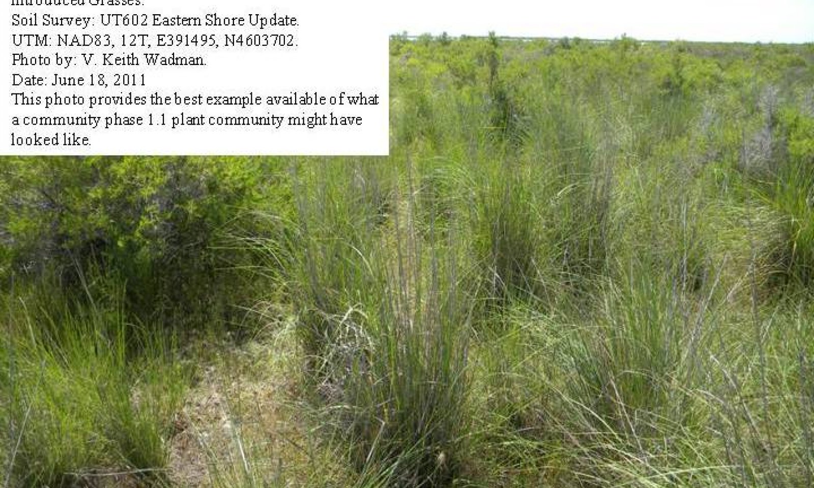
Black Greasewood/Alkali Sacaton Community Phase
Figure 7. Community Phase 1.1
The Black Greasewood/Alkali Sacaton Community Phase (1.1) is characterized by an open black greasewood shrub canopy, small amounts of basin big sagebrush and shadscale saltbush may also present. The site however, has a grassland aspect with alkali sacaton, alkali bluegrass and basin wildrye dominating the herbaceous layer. Other commonly occurring grasses and grasslikes include saltgrass, Douglas sedge and Baltic rush. Other perennial grasses, shrubs, and forbs are also present. The composition by air-dry weight is approximately 85 percent perennial grasses, 5 percent forbs, and 10 percent shrubs. Bare ground is variable (20 to 40 percent) depending on the amount of biological crust (0 to 15 percent), and plant cover.
The following tables provide examples of the typical vegetative floristics of a community phase 1.1 plant community.Figure 8. Annual production by plant type (representative values) or group (midpoint values)
Table 5. Annual production by plant type
Plant type Low
(lb/acre)Representative value
(lb/acre)High
(lb/acre)Grass/Grasslike 750 1500 2200 Shrub/Vine 90 180 250 Forb 45 90 130 Total 885 1770 2580 Table 6. Ground cover
Tree foliar cover 0% Shrub/vine/liana foliar cover 0-10% Grass/grasslike foliar cover 50-60% Forb foliar cover 0-10% Non-vascular plants 0% Biological crusts 0% Litter 0% Surface fragments >0.25" and <=3" 0% Surface fragments >3" 0% Bedrock 0% Water 0% Bare ground 0% Table 7. Canopy structure (% cover)
Height Above Ground (ft) Tree Shrub/Vine Grass/
GrasslikeForb <0.5 – – – – >0.5 <= 1 – – – 0-10% >1 <= 2 – – 55-65% – >2 <= 4.5 – 0-10% – – >4.5 <= 13 – – – – >13 <= 40 – – – – >40 <= 80 – – – – >80 <= 120 – – – – >120 – – – – Figure 9. Plant community growth curve (percent production by month). UT0011 , PNC. Excellent Condition.
Jan Feb Mar Apr May Jun Jul Aug Sep Oct Nov Dec J F M A M J J A S O N D 0 0 5 25 50 10 0 0 5 5 0 0 State 2
Current Potential StateThe current potential state is similar to the reference state, however invasive grasses and/ or forbs are now present in all community phases. This state is still dominated by an open canopy of black greasewood, however depending on disturbance history, basin big sagebrush and rubber rabbitbrush may be prominent on the site. Alkali sacaton, alkali bluegrass and basin wildrye are still the primary perennial grass species however, saltgrass, Baltic rush, cheatgrass and other less palatable species make up a larger portion of the herbaceous layer.
Primary disturbance mechanisms include native herbivore grazing and proper domestic livestock grazing. Timing of these disturbances dictates the ecological dynamics that occur. The current potential state is still self-sustaining; but is losing resistance to change due to lower resilience following disturbances. When disturbances occur, the rate of recovery is variable depending on severity.
Current Potential State: Black Greasewood/ Alkali Sacaton state with variations within a basin big sagebrush and/or rubber rabbitbrush shrubland community. Invasive plants are present.
Indicators: A community dominated by greasewood and/or rubber rabbitbrush where native perennial grasses and forbs are also present. Invasive grasses and/or forbs are present.
Feedbacks: Frequent disturbances that may allow the dominance of annual invasive species such as cheatgrass to dominate.
At-risk Community Phase: As increased disturbance frequency allows for the dominance of annual grasses, such as cheatgrass, this community is at greater risk.
Trigger: Reoccurring disturbance that results in a dominance of annual grasses in the herbaceous layer.Community 2.1
Black Greasewood, Alkali Sacaton, Invasive Weed Community Phase
Figure 10. Community Phase 2.1
The Black Greasewood, Alkali Sacaton, Invasive Weed Community Phase (2.1) is characterized by a black greasewood shrub canopy with alkali sacaton, alkali bluegrass and basin wildrye still dominating the herbaceous layer. Non-native species including cheatgrass, mustard species, alyssum, fivehorn smotherweed and Halogeton are present. Other grasses and grasslikes including saltgrass, Douglas sedge and Baltic rush are increasing and preferred species are decreasing. The composition by air-dry weight is approximately 60 percent perennial grasses, 10 percent forbs, and 30 percent shrubs. Bare ground is variable (20 to 50 percent) depending on the amount of biological crust (0 to 15 percent), and plant cover.
The following tables provide examples of the typical vegetative floristics of a community phase 2.1 plant community.Figure 11. Annual production by plant type (representative values) or group (midpoint values)
Table 8. Annual production by plant type
Plant type Low
(lb/acre)Representative value
(lb/acre)High
(lb/acre)Grass/Grasslike 765 1490 2210 Shrub/Vine 90 175 260 Forb 45 90 130 Total 900 1755 2600 Table 9. Ground cover
Tree foliar cover 0% Shrub/vine/liana foliar cover 10-20% Grass/grasslike foliar cover 40-50% Forb foliar cover 10-10% Non-vascular plants 0% Biological crusts 0% Litter 0% Surface fragments >0.25" and <=3" 0% Surface fragments >3" 0% Bedrock 0% Water 0% Bare ground 30-50% Table 10. Canopy structure (% cover)
Height Above Ground (ft) Tree Shrub/Vine Grass/
GrasslikeForb <0.5 – – – – >0.5 <= 1 – – – 0-10% >1 <= 2 – – 55-65% – >2 <= 4.5 – 0-10% – – >4.5 <= 13 – – – – >13 <= 40 – – – – >40 <= 80 – – – – >80 <= 120 – – – – >120 – – – – Figure 12. Plant community growth curve (percent production by month). UT0011 , PNC. Excellent Condition.
Jan Feb Mar Apr May Jun Jul Aug Sep Oct Nov Dec J F M A M J J A S O N D 0 0 5 25 50 10 0 0 5 5 0 0 Community 2.2
Black Greasewood, Invasive Weed Community Phase
Figure 13. Community Phase 2.2
The Black Greasewood, Invasive Weed Community Phase is characterized by a black greasewood and/or basin big sagebrush shrub canopy. Alkali sacaton, alkali bluegrass, and basin wildrye are much reduced in the understory. Non-native species including cheatgrass, mustard species, alyssum, fivehorn smotherweed and Halogeton often dominate the site. Other commonly occurring grasses and grasslikes include saltgrass, Baltic rush may be increasing and preferred species are decreasing. The composition by air-dry weight is less than 20 percent perennial grasses, 30 percent forbs, and 50 percent shrubs. Bare ground is variable (20 to 60 percent) depending on the amount of biological crusts (0 to 5 percent), and plant cover.
The following tables provide examples of the typical vegetative floristics of a community phase 2.2 plant community.Figure 14. Annual production by plant type (representative values) or group (midpoint values)
Table 11. Annual production by plant type
Plant type Low
(lb/acre)Representative value
(lb/acre)High
(lb/acre)Grass/Grasslike 600 1000 1400 Shrub/Vine 600 800 900 Forb 200 300 400 Total 1400 2100 2700 Table 12. Ground cover
Tree foliar cover 0% Shrub/vine/liana foliar cover 20-50% Grass/grasslike foliar cover 30-50% Forb foliar cover 10-30% Non-vascular plants 0% Biological crusts 0-0% Litter 0% Surface fragments >0.25" and <=3" 0% Surface fragments >3" 0% Bedrock 0% Water 0% Bare ground 30-50% Table 13. Canopy structure (% cover)
Height Above Ground (ft) Tree Shrub/Vine Grass/
GrasslikeForb <0.5 – – – – >0.5 <= 1 – – – 0-10% >1 <= 2 – – 55-65% – >2 <= 4.5 – 0-10% – – >4.5 <= 13 – – – – >13 <= 40 – – – – >40 <= 80 – – – – >80 <= 120 – – – – >120 – – – – Figure 15. Plant community growth curve (percent production by month). UT0011 , PNC. Excellent Condition.
Jan Feb Mar Apr May Jun Jul Aug Sep Oct Nov Dec J F M A M J J A S O N D 0 0 5 25 50 10 0 0 5 5 0 0 Pathway 2.1a
Community 2.1 to 2.2
Black Greasewood, Alkali Sacaton, Invasive Weed Community Phase
Black Greasewood, Invasive Weed Community PhaseThis pathway occurs when events favor a decrease in palatable perennial grasses and grasslikes and an increase in less palatable species such as saltgrass and baltic rush. Non-native annuals including cheatgrass and fivehorned smotherweed may eventually dominate the community. Events may include extended drought, improper livestock grazing, and fire that it increase annuals and decrease desirable perennials.
Key drivers
-
Fire
-
Livestock grazing or browsing
-
Fire frequency
Pathway 2.2a
Community 2.2 to 2.1
Black Greasewood, Invasive Weed Community Phase
Black Greasewood, Alkali Sacaton, Invasive Weed Community PhaseThis pathway occurs when events favor an increase in palatable perennial grasses and grasslikes, and a decrease in less palatable species such as saltgrass and Baltic rush. Non-native annuals, including cheatgrass and fivehorn smotherweed become less dominate in the community. Events may include extended periods with above average moisture, carefully managed livestock grazing, and the absence of fire, which, in combination, can decrease annuals and less palatable perennials and increase more desirable perennial vegetation.
State 3
Disturbed StateThis state occurs when the site is plowed or disked and planted to various rangeland grasses. Tall wheatgrass, crested wheatgrass, and Russian wildrye are the most commonly seeded species. These seedings may be very clean and healthy or may have various amounts of non-native annuals including, but are not limited to Russian thistle, cheatgrass, western tansy mustard, broom snakeweed, alyssum, fivehorn smotherweed, and annual Cryptantha.
Invasive Forb State: Range seeding community phases influenced by livestock grazing practices and weather cycles.
Indicators: Perennial rangeland seeding with annual, invasive forbs and grasses present in various amounts.
Feedbacks: Livestock grazing practices and weather cycles that maintain or degrade the range seeding and suppress or increase the non-native annuals present in the community.
Trigger: The increased establishment of cheatgrass and other annuals that may increase the sites fire interval, decrease perennial seeding production and increase bare ground.Community 3.1
Seeded Range Community Phase.
Figure 16. Community Phase 3.1
The Seeded Range Community Phase (3.1) has been mechanically plowed, disked, or burned and then seeded to rangeland grasses including crested wheatgrass, tall wheatgrass, and/or Russian wildrye. Black greasewood, rubber rabbitbrush, and/or basin big sage may be present in small amounts. Annuals including cheatgrass, Halogeton, various mustard species, and other non-native species are also present in small amounts. During above average moisture years, these species may become prominent enough in the stand to cause a fire hazard. Tall wheatgrass is sometimes irrigated.
The following tables provide examples of the typical vegetative floristics of a community phase 3.1 plant community.Figure 17. Annual production by plant type (representative values) or group (midpoint values)
Table 14. Annual production by plant type
Plant type Low
(lb/acre)Representative value
(lb/acre)High
(lb/acre)Grass/Grasslike 600 1000 1300 Forb 100 150 200 Shrub/Vine 40 100 150 Total 740 1250 1650 Table 15. Ground cover
Tree foliar cover 0% Shrub/vine/liana foliar cover 0-10% Grass/grasslike foliar cover 20-30% Forb foliar cover 10-10% Non-vascular plants 0% Biological crusts 0% Litter 0% Surface fragments >0.25" and <=3" 0% Surface fragments >3" 0% Bedrock 0% Water 0% Bare ground 50-60% Table 16. Canopy structure (% cover)
Height Above Ground (ft) Tree Shrub/Vine Grass/
GrasslikeForb <0.5 – – 10-15% 5-10% >0.5 <= 1 – – 25-35% – >1 <= 2 – – 40-50% – >2 <= 4.5 – – 10-15% – >4.5 <= 13 – – – – >13 <= 40 – – – – >40 <= 80 – – – – >80 <= 120 – – – – >120 – – – – Community 3.2
Failed Range Seeding Community Phase
Figure 18. Community Phase 3.2
Failed Range Seeding Community Phase (3.2) has been mechanically plowed, disked, or burned, then seeded to range seeding species including crested wheatgrass, tall wheatgrass, and/or Russian wildrye. Poor management and/or drought causes the seeding to fail. Black greasewood, rubber rabbitbrush and/or basin big sage may be present and increasing in the stand. Cheatgrass, Halogeton, various mustard species and other non-native species are present and often dominate the community.
The following tables provide examples of the typical vegetative floristics of a community phase 3.2 plant community.Figure 19. Annual production by plant type (representative values) or group (midpoint values)
Table 17. Annual production by plant type
Plant type Low
(lb/acre)Representative value
(lb/acre)High
(lb/acre)Grass/Grasslike 500 700 900 Forb 100 150 200 Shrub/Vine 40 100 150 Total 640 950 1250 Table 18. Ground cover
Tree foliar cover 0% Shrub/vine/liana foliar cover 0-10% Grass/grasslike foliar cover 20-30% Forb foliar cover 10-10% Non-vascular plants 0% Biological crusts 0% Litter 0% Surface fragments >0.25" and <=3" 0% Surface fragments >3" 0% Bedrock 0% Water 0% Bare ground 50-60% Table 19. Canopy structure (% cover)
Height Above Ground (ft) Tree Shrub/Vine Grass/
GrasslikeForb <0.5 – – 10-15% 5-10% >0.5 <= 1 – – 25-35% – >1 <= 2 – – 40-50% – >2 <= 4.5 – – 10-15% – >4.5 <= 13 – – – – >13 <= 40 – – – – >40 <= 80 – – – – >80 <= 120 – – – – >120 – – – – Pathway 3.1a
Community 3.1 to 3.2
Seeded Range Community Phase.
Failed Range Seeding Community PhaseThis pathway occurs when events favor a decrease in seeded rangeland species and an increase in unwanted invasive annuals. Events may include extended drought and improper livestock grazing that increases annuals and decreases desirable perennials.
Key drivers
-
Fire
-
Livestock grazing or browsing
-
Fire frequency
Pathway 3.2a
Community 3.2 to 3.1
Failed Range Seeding Community Phase
Seeded Range Community Phase.This pathway occurs when events favor a increase in seeded rangeland species and a reduction in unwanted invasive annuals. Events may include a series of above average moisture years and proper livestock grazing.
Transition T1A
State 1 to 2This transition is from the native perennial warm-season and cool season grasses and grasslike understory in the reference state to a state that contains non-native, invasive species. Events may include the establishment of invasive grasses and forbs, and an increase in black greasewood, basin big sagebrush, and/or rubber rabbitbrush. Factors that drive such events include: improper livestock grazing of perennial grasses, prolonged drought, and the presence of a seed source for invasive species. Fire may also be a driver for this change in some instances. Invasive species such as cheatgrass, have been known to invade intact perennial plant communities with little to no disturbance. Once invasive species are found in the plant community a threshold has been crossed.
Key drivers
-
Nonnative plant species presence and/or establishment
Transition T2B
State 2 to 3This transition is from the current potential state to a failed seeded rangeland community phase when the site has been plowed, disked, and/or burned, and seeded to adapted rangeland species including tall wheatgrass, crested wheatgrass, or Russian wildrye. Factors that drive such events include, improper livestock grazing of perennial grasses, prolonged drought for seeding establishment, and poor control of unwanted invasive species. Once the site is converted, a threshold has been crossed.
Transition T2B
State 2 to 3This transition is from the current potential state to a failed seeded rangeland community phase. Site is plowed, disked and/or burned, and seeded to adapted rangeland species including tall wheatgrass, crested wheatgrass or Russian wilrye. Factors that drive such events include, improper livestock grazing of perennial grasses, prolonged drought for seeding establishment, and poor control of unwanted invasive species. Once site is converted, a threshold has been crossed.
Additional community tables
Table 20. Community 1.1 plant community composition
Group Common name Symbol Scientific name Annual production () Foliar cover (%) Grass/Grasslike1 Primary Grasses 1030–1480 saltgrass DISP Distichlis spicata 370–460 – alkali sacaton SPAI Sporobolus airoides 280–370 – basin wildrye LECI4 Leymus cinereus 95–185 – Douglas' sedge CADO2 Carex douglasii 55–95 – 3 Secondary Grasses 95–185 squirreltail ELEL5 Elymus elymoides 20–55 – foxtail barley HOJU Hordeum jubatum 20–55 – beardless wildrye LETR5 Leymus triticoides 20–55 – mat muhly MURI Muhlenbergia richardsonis 20–55 – western wheatgrass PASM Pascopyrum smithii 20–55 – Nuttall's alkaligrass PUNU2 Puccinellia nuttalliana 20–55 – alkali cordgrass SPGR Spartina gracilis 20–55 – Shrub/Vine2 Priamary Shrubs 95–185 greasewood SAVE4 Sarcobatus vermiculatus 95–185 – 5 Secondary Shrubs 55–95 iodinebush ALOC2 Allenrolfea occidentalis 20–55 – basin big sagebrush ARTRT Artemisia tridentata ssp. tridentata 20–55 – fourwing saltbush ATCA2 Atriplex canescens 20–55 – Gardner's saltbush ATGA Atriplex gardneri 20–55 – basin saltbush ATTR3 Atriplex tridentata 20–55 – whiteflower rabbitbrush CHAL9 Chrysothamnus albidus 20–55 – skunkbush sumac RHTRT Rhus trilobata var. trilobata 20–55 – Forb4 95–185 silverscale saltbush ATAR2 Atriplex argentea 20–55 – fiddleleaf hawksbeard CRRU3 Crepis runcinata 20–55 – Drummond's goldenbush ISDR Isocoma drummondii 20–55 – povertyweed IVAX Iva axillaris 20–55 – King's mousetail IVKI Ivesia kingii 20–55 – alkali mallow MALE3 Malvella leprosa 20–55 – hollyleaf clover TRGY Trifolium gymnocarpon 20–55 – Table 21. Community 2.1 plant community composition
Group Common name Symbol Scientific name Annual production () Foliar cover (%) Grass/Grasslike1 Primary Grasses 1040–1480 saltgrass DISP Distichlis spicata 400–500 – alkali sacaton SPAI Sporobolus airoides 200–250 – basin wildrye LECI4 Leymus cinereus 80–150 – Douglas' sedge CADO2 Carex douglasii 50–90 – 3 Secondary Grasses 120–200 cheatgrass BRTE Bromus tectorum 50–100 – squirreltail ELEL5 Elymus elymoides 20–55 – foxtail barley HOJU Hordeum jubatum 20–55 – beardless wildrye LETR5 Leymus triticoides 20–55 – mat muhly MURI Muhlenbergia richardsonis 20–55 – western wheatgrass PASM Pascopyrum smithii 20–55 – Nuttall's alkaligrass PUNU2 Puccinellia nuttalliana 20–55 – alkali cordgrass SPGR Spartina gracilis 20–55 – Shrub/Vine2 Priamary Shrubs 120–200 greasewood SAVE4 Sarcobatus vermiculatus 120–200 – 5 Secondary Shrubs 200–300 basin big sagebrush ARTRT Artemisia tridentata ssp. tridentata 50–100 – fourwing saltbush ATCA2 Atriplex canescens 20–55 – Gardner's saltbush ATGA Atriplex gardneri 20–55 – basin saltbush ATTR3 Atriplex tridentata 20–55 – whiteflower rabbitbrush CHAL9 Chrysothamnus albidus 20–55 – skunkbush sumac RHTRT Rhus trilobata var. trilobata 20–55 – iodinebush ALOC2 Allenrolfea occidentalis 20–55 – Forb4 Forbs 150–200 field pennycress THAR5 Thlaspi arvense 20–55 – hollyleaf clover TRGY Trifolium gymnocarpon 20–55 – silverscale saltbush ATAR2 Atriplex argentea 20–55 – fivehorn smotherweed BAHY Bassia hyssopifolia 20–55 – fiddleleaf hawksbeard CRRU3 Crepis runcinata 20–55 – Drummond's goldenbush ISDR Isocoma drummondii 20–55 – povertyweed IVAX Iva axillaris 20–55 – King's mousetail IVKI Ivesia kingii 20–55 – alkali mallow MALE3 Malvella leprosa 20–55 – Russian thistle SAKA Salsola kali 25–50 – tall tumblemustard SIAL2 Sisymbrium altissimum 25–50 – herb sophia DESO2 Descurainia sophia 25–50 – Table 22. Community 2.2 plant community composition
Group Common name Symbol Scientific name Annual production () Foliar cover (%) Grass/Grasslike1 Primary Grasses 400–600 saltgrass DISP Distichlis spicata 350–400 – alkali sacaton SPAI Sporobolus airoides 100–150 – basin wildrye LECI4 Leymus cinereus 40–100 – Douglas' sedge CADO2 Carex douglasii 0–30 – 3 Secondary Grasses 400–500 cheatgrass BRTE Bromus tectorum 300–400 – squirreltail ELEL5 Elymus elymoides 0–20 – foxtail barley HOJU Hordeum jubatum 0–20 – beardless wildrye LETR5 Leymus triticoides 0–20 – mat muhly MURI Muhlenbergia richardsonis 0–20 – western wheatgrass PASM Pascopyrum smithii 0–20 – Nuttall's alkaligrass PUNU2 Puccinellia nuttalliana 0–20 – alkali cordgrass SPGR Spartina gracilis 0–20 – Shrub/Vine2 Priamary Shrubs 160–300 greasewood SAVE4 Sarcobatus vermiculatus 160–300 – 5 Secondary Shrubs 400–500 basin big sagebrush ARTRT Artemisia tridentata ssp. tridentata 150–300 – skunkbush sumac RHTRT Rhus trilobata var. trilobata 20–55 – fourwing saltbush ATCA2 Atriplex canescens 20–55 – Gardner's saltbush ATGA Atriplex gardneri 20–55 – basin saltbush ATTR3 Atriplex tridentata 20–55 – whiteflower rabbitbrush CHAL9 Chrysothamnus albidus 20–55 – iodinebush ALOC2 Allenrolfea occidentalis 20–55 – Forb4 Forbs 200–400 Russian thistle SAKA Salsola kali 150–200 – desert madwort ALDE Alyssum desertorum 50–100 – tall tumblemustard SIAL2 Sisymbrium altissimum 50–75 – fivehorn smotherweed BAHY Bassia hyssopifolia 50–75 – lambsquarters CHAL7 Chenopodium album 20–55 – field bindweed COAR4 Convolvulus arvensis 20–55 – fiddleleaf hawksbeard CRRU3 Crepis runcinata 20–55 – herb sophia DESO2 Descurainia sophia 20–55 – Drummond's goldenbush ISDR Isocoma drummondii 20–55 – povertyweed IVAX Iva axillaris 20–55 – King's mousetail IVKI Ivesia kingii 20–55 – prickly lettuce LASE Lactuca serriola 20–55 – alkali mallow MALE3 Malvella leprosa 20–55 – field pennycress THAR5 Thlaspi arvense 20–55 – hollyleaf clover TRGY Trifolium gymnocarpon 20–55 – annual ragweed AMAR2 Ambrosia artemisiifolia 20–55 – silverscale saltbush ATAR2 Atriplex argentea 20–55 – Table 23. Community 3.1 plant community composition
Group Common name Symbol Scientific name Annual production () Foliar cover (%) Grass/Grasslike1 Dominant Grasses 600–1200 tall wheatgrass THPO7 Thinopyrum ponticum 0–1200 – crested wheatgrass AGCR Agropyron cristatum 0–1000 – Russian wildrye PSJU3 Psathyrostachys juncea 0–800 – 2 Sib-dominant Grasses 200–300 cheatgrass BRTE Bromus tectorum 50–75 – saltgrass DISP Distichlis spicata 50–75 – Forb3 Forbs 100–300 desert madwort ALDE Alyssum desertorum 25–50 – annual ragweed AMAR2 Ambrosia artemisiifolia 25–50 – lambsquarters CHAL7 Chenopodium album 25–50 – field bindweed COAR4 Convolvulus arvensis 25–50 – herb sophia DESO2 Descurainia sophia 25–50 – prickly lettuce LASE Lactuca serriola 25–50 – Russian thistle SAKA Salsola kali 25–50 – tall tumblemustard SIAL2 Sisymbrium altissimum 25–50 – field pennycress THAR5 Thlaspi arvense 25–50 – Shrub/Vine4 Shrubs 50–150 basin big sagebrush ARTRT Artemisia tridentata ssp. tridentata 0–100 – greasewood SAVE4 Sarcobatus vermiculatus 25–100 – Table 24. Community 3.2 plant community composition
Group Common name Symbol Scientific name Annual production () Foliar cover (%) Grass/Grasslike1 Dominant Grasses 100–400 tall wheatgrass THPO7 Thinopyrum ponticum 0–150 – crested wheatgrass AGCR Agropyron cristatum 0–150 – Russian wildrye PSJU3 Psathyrostachys juncea 0–100 – 2 Sub-Dominant Grasses 500–700 cheatgrass BRTE Bromus tectorum 300–400 – saltgrass DISP Distichlis spicata 50–125 – Forb3 Forbs 200–500 Russian thistle SAKA Salsola kali 100–150 – tall tumblemustard SIAL2 Sisymbrium altissimum 50–75 – field pennycress THAR5 Thlaspi arvense 50–75 – desert madwort ALDE Alyssum desertorum 50–75 – annual ragweed AMAR2 Ambrosia artemisiifolia 50–75 – lambsquarters CHAL7 Chenopodium album 50–75 – field bindweed COAR4 Convolvulus arvensis 50–75 – herb sophia DESO2 Descurainia sophia 50–75 – prickly lettuce LASE Lactuca serriola 50–75 – Shrub/Vine4 Shrubs 50–150 basin big sagebrush ARTRT Artemisia tridentata ssp. tridentata 0–100 – greasewood SAVE4 Sarcobatus vermiculatus 25–100 – Interpretations
Animal community
--Threatened and Endangered Species--
This section will be populated as more information becomes available for the Alkali Bottom (Alkali Sacaton) ecological site.
--Wildlife Interpretation--
The Alkali Bottom (Alkali Sacaton) ecological site, in its reference state, produced large amounts of nutritious forage that was utilized by native herbivores including deer and antelope who lived here along with their associated predators. Although much of this site is presently different from the reference state, it is still very important as a wildlife habitat. Other wildlife commonly observed using this site include rabbit, coyote, badger, fox, and various waterfowl species.
In many locations, this ecological site and its associated wetland ecological sites provide critical habitat for migrating birds from both the Pacific and Central Flyways of North America. These areas contain abundant food for birds.
--Grazing Interpretations--
The Alkali Bottom (Alkali Sacaton) ecological site provide good spring, fall, and winter grazing conditions for domestic livestock due to its accessibility and its supply of nutritious forage. The plant community is primarily grasses, with the majority of canopy cover being attributed to alkali sacaton, alkali bluegrass, and basin wildrye. Improper livestock grazing can cause these species to decrease while annual forbs, black greasewood and rabbitbrush increase.
Healthy alkali sacaton produces an abundant supply of exceptionally long-lived seed, which enables this species to extend its stand rather vigorously on favorable areas.
When the Alkali Bottom (Alkali Sacaton) ecologial site is stressed, cheatgrass, Russian thistle and halogeton are likely to invade.Hydrological functions
The soils associated with the Alkali Bottom (Alkali Sacaton) ecological site are generally in Hydrologic Soil Group B. On these sites runoff potential is low to moderate and infiltration rates are moderate, depending on slope and ground cover/health (NRCS National Engineering Handbook). Hydrological groups are used in equations that estimate runoff from rainfall. These estimates are needed for solving hydrologic problems that arise in planning watershed-protection and flood-prevention projects and for designing structures for the use, control and disposal of water. In areas similar to the reference state where ground cover is adequate infiltration is increased, and runoff potential is decreased. In areas where ground cover is less than 50 percent, infiltration is reduced and runoff potential is increased. Heavy use by domestic livestock affects hydrology in two ways: trampling and heavy grazing. Trampling increases bulk density and breaks down soil aggregates. This results in decreased infiltration rates and increased runoff. Heavy grazing can also alter the hydrology by decreasing plant cover and increasing bare ground. Fire can also affect hydrology, but the results are variable. Fire intensity, fuel type, soil, climate, and topography can each have different influences. Fires can increase areas of bare ground and hydrophobic layers that reduce infiltration and increase runoff.
Different plant communities affect hydrology in different ways. Weedy communities such as state 2 and 3 alter the hydrology by changing the surface soil texture. Soil surfaces will typically become siltier which reduces infiltration and increases runoff potential. (National Range and Pasture Handbook, 2003)Recreational uses
Recreation activities include aesthetic value and good opportunities for hiking, horseback riding, hunting, and off-road vehicle use. Due to the high erosion potential after a surface disturbance, care should be taken when planning recreational activities. Camp sites are usually limited due to lack of sheltering trees or rock outcrop.
Wood products
None
Other information
--Poisonous/Toxic Plant Species--
The toxic plant associated with this site include broom snakeweed and Russian thistle.
Broom snakeweed contains steroids, terpenoids, saponins, and flavones that can cause abortions or reproductive failure in sheep and cattle, however cattle are most susceptible. These toxins are most abundant during active growth and leafing stage. Cattle and sheep will typically only graze broom snakeweed when other forage is unavailable and generally in winter when toxicity levels are at their lowest (Knight and Walter, 2001).
Russian thistle can cause nitrate and to a lesser extent oxalate poisoning, which affects all classes of livestock. The buildup of nitrates in these plants is highly dependent upon environmental factors, such as after a rain storm during a drought, cool and/or cloudy days, and soils high in nitrogen and low in sulfur and phosphorus, all which cause increased nitrate accumulation. Nitrate collects in the stems and can persist throughout the growing season. Clinical signs of nitrate poisoning include drowsiness, weakness, muscular tremors, increased heart and respiratory rates, staggering gait, and death. Conversely, oxalate poisoning causes kidney failure; clinical signs include muscle tremors, tetany, weakness, and depression. Poisoning generally occurs when livestock consume and are not accustomed to grazing oxalate-containing plants. Animals with prior exposure to oxalates have increased numbers of oxalate-degrading rumen microflora and thus are able to degrade the toxin before clinical poisoning can occur. (Knight and Walter, 2001).
--Invasive Plant Communities--
Generally, as ecological conditions deteriorate and perennial vegetation decreases due to disturbance (fire, over grazing, drought, off-road vehicle overuse, erosion, etc.) annual forbs and grasses will invade the site. Of particular concern in semi-arid environments are cheatgrass, Russian thistle, kochia, Halogeton, and annual mustards. The presence of these species depends on soil properties and moisture availability; however, these invaders are highly adaptive and can flourish in many locations. Once established, complete removal is difficult, but suppression may possible.
Cheatgrass and Russian thistle are common invaders to this site, especially in lower areas that concentrate nutrients and moisture. In some cases cheatgrass has been able to establish into an intact perennial grass and shrub community, but disturbed communities are more susceptible to invasion and domination. If growing conditions are conducive to invaders and the disturbance is not removed, these plants can create dense monocultures that can alter the nutrient cycling, erosion rates, and the fire regime of the area.
Fire Ecology
The ability for an ecological site to carry fire depends primarily on the present fuel load and plant moisture content. Fire was a typical disturbance in the historic climax plant community for this ecological site. The natural fire return interval is 30 to 100 years, where fires typically occur in the fall. When the site is degraded by the presence of invasive plants, the fire return interval may be shortened due to increased flashy fuels. The shortened fire return interval in the presence of invasive annual species is often sufficient to suppress the native plant community.Supporting information
Inventory data references
This site update was completed as part of the NRCS East Shore Soil Survey Update.
Type locality
Location 1: Davis County, UT Township/Range/Section T1N R1W S3 Location 2: Millard County, UT Township/Range/Section T16S R7W S24 Location 3: Weber County, UT Township/Range/Section T5N R2W S21 Location 4: Weber County, UT Township/Range/Section T6N R3W S23 Other references
Knight, A.P. and R.G. Walter. 2001. A guide to plant poisoning of animals in North America. Teton NewMedia. Jackson, WY.
National Engineering Handbook. US Department of Agriculture, Natural Resources Conservation Service. Available: http://www.info.usda.gov/CED/Default.cfm#National%20Engineering%20Handbook. Accessed February 25, 2008.
NPS.gov. 2008. Canyonlands National Park. Nature and Science. Available: http://www.nps.gov/cany/naturescience/. Accessed on January 4, 2008.
NRCS Grazing Lands Technology Institute. 2003. National Range and Pasture Handbook. Fort Worth, TX, USA: US Department of Agriculture, Natural Resources Conservation Service, 190-VI-NRPH.
Plant.USDA.gov, Natural Resources Conservation Service, Plants Database, accessed at various times.
United States Department of Agriculture Handbook 296, Land resource Regions and Major Land Resource Areas of the United States, the Caribbean, and the Pacific Basin, Issued 2006.
US Fish and Wildlife Service; Bear River Migratory Bird Refuge; BearRiver@fws.gov
Utah Climate Summaries. 2009. Available: http://www.wrcc.dri.edu/summary/climsmut.html. Accessed on February 25, 2008.Contributors
David J. Somerville
V. Keith Wadman, Brock BensonApproval
Jamin Johanson, 5/02/2025
Rangeland health reference sheet
Interpreting Indicators of Rangeland Health is a qualitative assessment protocol used to determine ecosystem condition based on benchmark characteristics described in the Reference Sheet. A suite of 17 (or more) indicators are typically considered in an assessment. The ecological site(s) representative of an assessment location must be known prior to applying the protocol and must be verified based on soils and climate. Current plant community cannot be used to identify the ecological site.
Author(s)/participant(s) Jack Alexander, Range Specialist, Synergy Resource Solutions, Inc. Julia Kluck, Soil Scientist, Synergy Resource Solutions, Inc. Shane Green, State Range Specialist, Utah NRCS Contact for lead author Shane.green@ut.usda.gov Date 02/20/2007 Approved by Approval date Composition (Indicators 10 and 12) based on Annual Production Indicators
-
Number and extent of rills:
No rills present. Very minor rill development may occur in sparsely vegetated areas. If rills are present, they should be widely spaced and not connected. Rill development may increase following large storm events, but should begin to heal during the following growing season. Frost heaving will accelerate recovery. Rill development may increase when run inflow enters site from adjacent sites that produce large amounts of runoff (i.e. steeper sites, slickrock, rock outcrop). Site is essentially level and rills do not form. -
Presence of water flow patterns:
Essentially none. Site is essentially level, water flow patterns are not expected to form. -
Number and height of erosional pedestals or terracettes:
None. Some plants may appear to have a pedestal but rather than be formed by erosion, the only place litter accumulates and soil collects is at plant bases forming the appearance of a pedestal. -
Bare ground from Ecological Site Description or other studies (rock, litter, lichen, moss, plant canopy are not bare ground):
10-20% bare ground* (soil with no protection from raindrop impact). Herbaceous communities are most likely to have lower values. As species composition by shrubs increases, bare ground is likely to increase. Poorly developed biological soil crust that is susceptible to raindrop splash erosion should be recorded as bare ground. Very few if any bare spaces of greater than 1 square foot. *From existing ESD -
Number of gullies and erosion associated with gullies:
No gullies present. -
Extent of wind scoured, blowouts and/or depositional areas:
No evidence of active wind-generated soil movement. Wind scoured (blowouts) and depositional areas are very rarely present. If present they have muted features and are mostly stabilized with vegetation and/or biological crust. -
Amount of litter movement (describe size and distance expected to travel):
Most litter resides in place with some redistribution caused by water and wind movement. Very minor litter removal may occur in flow patterns and rills with deposition occurring at points of obstruction. The majority of litter accumulates at the base of plants. Some leaves, stems, and small twigs may accumulate in soil depressions adjacent to plants. Woody stems are not likely to move. -
Soil surface (top few mm) resistance to erosion (stability values are averages - most sites will show a range of values):
Soil surface is generally not stable due to soil structure and chemistry (average soil stability rating of 3). -
Soil surface structure and SOM content (include type of structure and A-horizon color and thickness):
This description is based on the modal soil (Bramwell SiL, soil survey area: 611, Tooele). This site has 22 correlated soils, resulting in variation of each of these attributes. Unless working on a location with the modal soil, it is critical to supplement this description with the soil-specific information from the published soil survey. Soil surface horizon is typically 10 inches deep. Structure is typically moderate thin platy structure. Color is typically light gray (10YR 6/1), dark gray (10YR 4/1) moist. An ochric horizon extends to a depth of 10 inches. An ochric horizon typically extends to a depth of 2 to 10 inches. The ochric horizon is a surface horizon lacking fine stratification and which is either light colored, or thin, or has an low organic carbon content, or is massive and (very) hard when dry. The A horizon would be expected to be more strongly developed under plant canopies. It is important if you are sampling to observe the A horizon under plant canopies as well as the interspaces. -
Effect of community phase composition (relative proportion of different functional groups) and spatial distribution on infiltration and runoff:
Vascular plants and any well-developed biological soil crusts (where present) will break raindrop impact and splash erosion. Spatial distribution of vascular plants and interspaces between well-developed biological soil crusts (where present) provide detention storage and surface roughness that slows runoff allowing time for infiltration. With the physiographic location of the site being in stream terraces, alluvial flats, drainage ways, and flood plains this site is one of the terminal accumulation sites for runoff water. As such, infiltration is naturally facilitated. Natural erosion would be expected in severe thunder storms or heavy spring runoff. When perennial grasses decrease, reducing ground cover and increasing bare ground, runoff is expected to increase and any associated infiltration reduced. -
Presence and thickness of compaction layer (usually none; describe soil profile features which may be mistaken for compaction on this site):
None. Naturally occurring soil horizons may be harder than the surface because of an accumulation calcium carbonate and should not be considered as compaction layers. -
Functional/Structural Groups (list in order of descending dominance by above-ground annual-production or live foliar cover using symbols: >>, >, = to indicate much greater than, greater than, and equal to):
Dominant:
Perennial bunchgrasses, tall cool season (alkali sacaton, basin wildrye) > Rhizomatous grasses (saltgrass)Sub-dominant:
Perennial bunchgrasses, short cool season (Sandberg bluegrass) > resprouting shrubs (greasewood)Other:
The perennial grass/sprouting shrub (greasewood) functioning group is expected on this site.Additional:
Any of the communities listed in the reference state may occur. Refer to community descriptions in ESD. Functional/structural groups may appropriately contain non-native species if their ecological function is the same as the native species in the reference state (e.g. crested wheatgrass and Russian wildrye may substitute for mid stature cool season perennial native bunchgrasses.). Biological soil crust is variable in its expression on this site and is measured as a component of ground cover. Forbs can be expected to vary widely in their expression in the plant community based upon departures from average growing conditions. -
Amount of plant mortality and decadence (include which functional groups are expected to show mortality or decadence):
During years with average to above average precipitation, there should be very little recent mortality or decadence apparent in either the shrubs or grasses. Some mortality of bunchgrass and other shrubs may occur during very severe (long-term) droughts. There may be partial mortality of individual bunchgrasses and shrubs during less severe drought. Long-lived species dominate site. Open spaces from disturbance are quickly filled by new plants through seedlings and asexual reproduction (tillering). -
Average percent litter cover (%) and depth ( in):
Litter cover includes litter under plants. Most litter will be fine litter. Depth should be 1-2 leaf thickness in the interspaces and up to 1/2” under canopies. Litter cover may increase to 35-45% following years with favorable growing conditions. Excess litter may accumulate in absence of disturbance. Vegetative production may be reduced if litter cover exceeds 40%. *From ESD data -
Expected annual annual-production (this is TOTAL above-ground annual-production, not just forage annual-production):
1750 #/acre on an average year. Even the most stable communities exhibit a range of production values. Production will vary between communities and across the MRLA. Refer to the community descriptions in the ESD. Production will differ across the MLRA due to the naturally occurring variability in weather, soils, and aspect. The biological processes on this site are complex; therefore, representative values are presented in a land management context. -
Potential invasive (including noxious) species (native and non-native). List species which BOTH characterize degraded states and have the potential to become a dominant or co-dominant species on the ecological site if their future establishment and growth is not actively controlled by management interventions. Species that become dominant for only one to several years (e.g., short-term response to drought or wildfire) are not invasive plants. Note that unlike other indicators, we are describing what is NOT expected in the reference state for the ecological site:
Cheatgrass, Halogeton -
Perennial plant reproductive capability:
Reproduction restricted by effective precipitation, rock cover, soil depth, and generally harsh growing conditions; all to be expected for site. Site provides harsh environment for seedling establishment.
Print Options
Sections
Font
AAAAOther
PrintThe Ecosystem Dynamics Interpretive Tool is an information system framework developed by the USDA-ARS Jornada Experimental Range, USDA Natural Resources Conservation Service, and New Mexico State University.
Accessibility statement


