
Natural Resources
Conservation Service
-
Search


Major Land Resource Area or ecological site by name and/or ID.
PreviousSectionsNextGeneral information
Draft. A draft ecological site description is either incomplete or has not undergone quality control and quality assurance review.
MLRA notes
Major Land Resource Area (MLRA): 028A–Ancient Lake Bonneville
MLRA 28A occurs in Utah (82%), Nevada (16%), and Idaho (2%). It makes up about 36,775 square miles (95,300 square kilometers). About three-fifths of this area is federally owned land, large tracts of which are used for military training and testing purposes by the. A large area west and southwest of Great Salt Lake is a salty playa. This area is the farthest eastern extent of the Great Basin Section of the Basin and Range Province of the Intermontane Plateaus. It is an area of nearly level basins between widely separated mountain ranges trending north to south. The basins are bordered by long, gently sloping alluvial fans. The mountains are uplifted fault blocks with steep side slopes. They are not well dissected because of low rainfall in the MLRA. Most of the valleys are closed basins containing sinks or playa lakes. Elevation ranges from 3,950 to 6,560 feet (1,205 to 2,000 meters) in the basins and from 6,560 to 11,150 feet (2,000 to 3,400 meters) in the mountains.
Most of this area has alluvial valley fill and playa lakebed deposits at the surface. Great Salt Lake is all that remains of glacial Lake Bonneville, which covered this area during the most recent ice age. A level line on some mountain slopes indicates the former extent of this glacial lake. The uplifted mountains have exposed some Precambrian rocks at their margins. Most of the mountains in the interior of this area consist of tilted blocks of marine sediments from Cambrian to Mississippian age. Scattered outcrops of Tertiary continental sediments and volcanic rocks are throughout the area.
The average annual precipitation is 5 to 12 inches (125 to 305 millimeters) in the valleys and is as much as 49 inches (1,245 millimeters) in the mountains. Most of the rainfall occurs as high-intensity, convective thunderstorms during the growing season. The driest period is from midsummer to early autumn. Precipitation in winter typically occurs as snow. The average annual temperature is 39 to 53 degrees F (4 to 12 degrees C). The freeze-free period averages 165 days and ranges from 110 to 215 days, decreasing in length with elevation.
The dominant soil orders in this MLRA are Aridisols, Entisols, and Mollisols. The soils in the area dominantly have a mesic or frigid soil temperature regime, an aridic or xeric soil moisture regime, and mixed mineralogy. They generally are well drained or somewhat excessively drained, loamy or loamy-skeletal, and very deep.
Ecological site concept
This forest site occurs on sideslopes of mountains and moraines on all aspects. Slopes range from 8 to 75 percent. Elevations are 8500 to 11,000 feet.
Average annual precipitation is 25 to over 35 inches. Mean annual air temperature is 40 to 43 degrees F. The average growing season is 50 to 70 days.
The soils associated with this site are moderately deep to very deep. The soils are formed in till derived from quartzite or colluvium and residuum from limestone and calcareous shale, or granite. These soils are modified by large volumes of gravel, cobbles and stones throughout the profile.
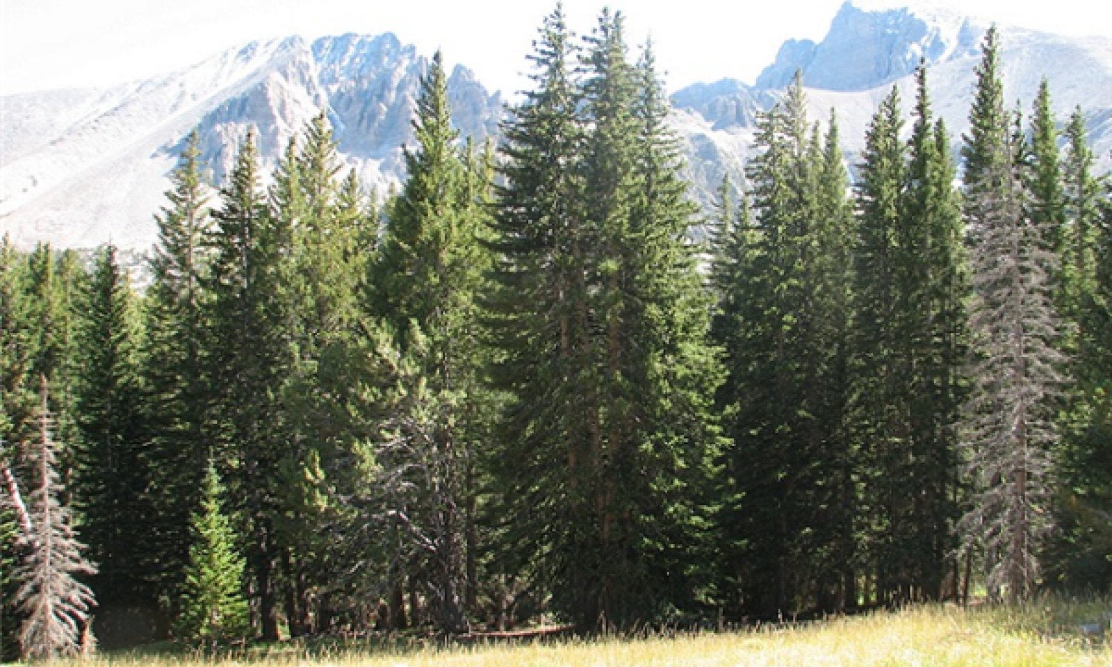
The reference state is dominated by Engelmann spruce with Rocky Mountain white fir (Abies concolor var. concolor), Rocky Mountain Douglas fir (Pseudotsuga menziesii var. glauca), and quaking aspen occurring sporadically within the tree canopy. An overstory canopy of 25 to 35 percent is assumed to be representative of tree dominance on this site in the pristine environment. Quaking aspen is recognized as an important seral species in the development of this forestland site.
Mountain gooseberry is the principal understory shrub. Western raspberry and snowberry are other important shrubs in the understory community. Mountain brome, and Columbia, western and/or Letterman needlegrass, are the most prevalent understory grasses. Starwort, Fendler meadowrue, dandelion, and daisy are common understory forbs.Table 1. Dominant plant species
Tree (1) Picea engelmannii
Shrub (1) Ribes montigenum
Herbaceous (1) Bromus marginatus
(2) Achnatherum nelsoniiPhysiographic features
This forest site occurs on sideslopes of mountains and moraines on all aspects. Slopes range from 8 to 75 percent. Elevations range from 8500 to 11,000 feet.
Table 2. Representative physiographic features
Landforms (1) Mountain
(2) Mountain slope
Elevation 8500 – 11000 ft Slope 8 – 75 % Aspect Aspect is not a significant factor Climatic features
Nevada’s climate is predominantly arid, with large daily ranges of temperature, infrequent severe storms, heavy snowfall in the higher mountains, and great location variations with elevation. Three basic geographical factors largely influence Nevada’s climate: continentality, latitude, and elevation. Continentality is the most important factor. The strong continental effect is expressed in the form of both dryness and large temperature variations. Nevada lies on the eastern, lee side of the Sierra Nevada Range, a massive mountain barrier that markedly influences the climate of the State. The prevailing winds are from the west, and as the warm moist air from the Pacific Ocean ascend the western slopes of the Sierra Range, the air cools, condensation occurs and most of the moisture falls as precipitation. As the air descends the eastern slope, it is warmed by compression, and very little precipitation occurs. The effects of this mountain barrier are felt not only in the West but throughout the state, with the result that the lowlands of Nevada are largely desert or steppes. The temperature regime is also affected by the blocking of the inland-moving maritime air. Nevada sheltered from maritime winds, has a continental climate with well-developed seasons and the terrain responds quickly to changes in solar heating.
Nevada lies within the mid-latitude belt of prevailing westerly winds which occur most of the year. These winds bring frequent changes in weather during the late fall, winter and spring months, when most of the precipitation occurs. To the south of the mid-latitude westerlies, lies a zone of high pressure in subtropical latitudes, with a center over the Pacific Ocean. In the summer, this high-pressure belt shifts northward over the latitudes of Nevada, blocking storms from the ocean. The resulting weather is mostly clear and dry during the summer and early fall, with scattered thundershowers. The eastern portion of the state receives significant summer thunderstorms generated from monsoonal moisture pushed up from the Gulf of California, known as the North American monsoon. The monsoon system peaks in August and by October the monsoon high over the Western U.S. begins to weaken and the precipitation retreats southward towards the tropics (NOAA 2004).
Average annual precipitation is 25 to over 35 inches. Mean annual air temperature is 40 to 43 degrees F. The average growing season is 50 to 70 days.Table 3 Representative climatic features
Frost-free period (average) 60 days Freeze-free period (average) 0 days Precipitation total (average) 30 in BarLineFigure 1. Monthly precipitation range
BarLineFigure 2. Monthly average minimum and maximum temperature
Figure 3. Annual precipitation pattern
Figure 4 Annual average temperature pattern
Climate stations used
-
(1) GREAT BASIN NP [USC00263340], Baker, NV
">Influencing water features
There are no influencing water features associated with this site.
Soil features
The soils associated with this site are moderately deep to very deep. The soils are formed in till derived from quartzite or colluvium and residuum from limestone and calcareous shale, or granite. These soils are modified by large volumes of gravel, cobbles and stones throughout the profile. Snow accumulation on this site persists into mid- to late spring when the soil is not frozen. Snowmelt at this time adds to the soil moisture supply. There is normally less than a one-inch thick layer of decomposing organic matter present on the soil surface. The soil temperature regime is cryic and the soil moisture regime is xeric. The soil series associated with this site include: Jumble, Keyole, Muiral, and Pirapeak.
The representative soil series is Muiral, classified as a Loamy-skeletal, mixed, superactive Calcic Haplocryepts. Diagnostic horizons include an ochric epipedon from the soil surface to 7 inches and a cambic horizon from 12 to 36 inches. Identifiable secondary calcium carbonates occur from 23 to 36 inches. Clay content in the particle control section averages 12 to 18 percent. Rock fragments range from 35 to 60 percent, with 25 to 55 percent gravel and 10 to 20 percent cobbles and stones. Reaction is slightly acid through moderately alkaline. Effervescence is noneffervescenct or slight effervescence. Lithology consists of sedimentary rocks such as limestone, dolomite, and hard siltstone.Table 4. Representative soil features
Parent material (1) Till – quartzite
(2) Colluvium – limestone and shale
(3) Residuum – dolomite
Surface texture (1) Very stony loam
(2) Extremely stony loam
(3) Extremely bouldery fine sandy loam
Family particle size (1) Loamy
Drainage class Well drained to somewhat excessively drained Permeability class Moderate to moderately rapid Soil depth 20 – 84 in Surface fragment cover <=3" 5 – 20 % Surface fragment cover >3" 15 – 40 % Available water capacity
(0-40in)1.9 – 3.5 in Calcium carbonate equivalent
(0-40in)0 – 15 % Electrical conductivity
(0-40in)0 – 2 mmhos/cm Sodium adsorption ratio
(0-40in)0 – 5 Soil reaction (1:1 water)
(0-40in)5.4 – 7.3 Subsurface fragment volume <=3"
(Depth not specified)25 – 55 % Subsurface fragment volume >3"
(Depth not specified)20 – 50 % Ecological dynamics
State and transition model
More interactive model formats are also available. View Interactive Models
Click on state and transition labels to scroll to the respective textEcosystem states
State 1 submodel, plant communities
State 1
Reference StateCommunity 1.1
Plant Community
Figure 5. P. Novak-Echenique, GBNP, NV708, MU 5291, 9/2011
This plant community is dominated by Engelmann spruce with Rocky Mountain white fir (Abies concolor var. concolor), Rocky Mountain Douglas fir (Pseudotsuga menziesii var. glauca), and quaking aspen occurring sporadically within the tree canopy. An overstory canopy of 25 to 35 percent is assumed to be representative of tree dominance on this site in the pristine environment. Quaking aspen is recognized as an important seral species in the development of this forestland site.
Mountain gooseberry is the principal understory shrub. Western raspberry and snowberry are other important shrubs in the understory community. Mountain brome, and Columbia, western and/or Letterman's needlegrass, are the most prevalent understory grasses. Starwort, Fendler's meadowrue, dandelion, and daisy are common understory forbs.Forest overstory.MATURE FORESTLAND: The visual aspect and vegetal structure are dominated by Engelmann's spruce that have reached or are near maximal heights for the site. Dominant trees average ten inches or greater in diameter at breast height. Tree canopy cover ranges from 25 to about 35 percent. Understory vegetation is strongly influenced by tree competition, overstory shading, duff accumulation, etc. Few seedlings and/or saplings of Engelmann's spruce or white fir occur in the understory.
Forest understory. Understory vegetative composition is about 35 percent grasses, 15 percent forbs and 50 percent shrubs and young trees when the average overstory canopy is medium (about 30 percent). Average understory production ranges from 100 to 300 pounds per acre with a medium canopy cover. Understory production includes the total annual production of all species within 4½ feet of the ground surface.
Figure 6. Annual production by plant type (representative values) or group (midpoint values)
Table 5. Annual production by plant type
Plant type Low
(lb/acre)Representative value
(lb/acre)High
(lb/acre)Grass/Grasslike 35 70 105 Shrub/Vine 35 70 105 Forb 15 30 45 Tree 15 30 45 Total 100 200 300 Additional community tables
Table 6. Community 1.1 plant community composition
Group Common name Symbol Scientific name Annual production () Foliar cover (%) Grass/Grasslike1 Primary Perennial Grasses 60–108 Letterman's needlegrass ACLE9 Achnatherum lettermanii 10–18 – Dore's needlegrass ACNED Achnatherum nelsonii ssp. dorei 10–18 – western needlegrass ACOCO Achnatherum occidentale ssp. occidentale 10–18 – mountain brome BRMA4 Bromus marginatus 10–18 – Ross' sedge CARO5 Carex rossii 10–18 – slender wheatgrass ELTR7 Elymus trachycaulus 10–18 – 2 Secondary Perennial Grasses 8–40 alpine fescue FEBR Festuca brachyphylla 2–10 – Cusick's bluegrass POCUE2 Poa cusickii ssp. epilis 2–10 – muttongrass POFE Poa fendleriana 2–10 – spike trisetum TRSP2 Trisetum spicatum 2–10 – Forb3 Perennial Forbs 14–70 yarrow ACHIL Achillea 2–10 – erigenia ERIGE Erigenia 2–10 – ragwort SENEC Senecio 2–10 – starwort STELL Stellaria 2–10 – common dandelion TAOFC Taraxacum officinale ssp. ceratophorum 2–10 – Fendler's meadow-rue THFE Thalictrum fendleri 2–10 – clover TRIFO Trifolium 2–10 – Shrub/Vine4 Primary Shrubs 40–84 gooseberry currant RIMO2 Ribes montigenum 20–48 – American red raspberry RUID Rubus idaeus 10–18 – snowberry SYMPH Symphoricarpos 10–18 – Tree5 Trees 33–66 Engelmann spruce PIEN Picea engelmannii 10–18 – limber pine PIFL2 Pinus flexilis 2–10 – Rocky Mountain Douglas-fir PSMEG Pseudotsuga menziesii var. glauca 1–2 – Table 7. Community 1.1 forest overstory composition
Common name Symbol Scientific name Nativity Height ft Canopy cover (%) Diameter in Basal area (square ft/acre) TreeEngelmann spruce PIEN Picea engelmannii Native – 80-90 – 0 quaking aspen POTR5 Populus tremuloides Native – 5-10 – 0 Interpretations
Animal community
Livestock Interpretations:
Livestock may concentrate on this site in order to take advantage of the shade and shelter offered by the tree overstory. Many areas may not be used because of steep slopes or lack of adequate water. Attentive grazing management is required where this site is used during the earlier stages of forest succession such as the shrub-herbaceous and sapling stages. During these early stages the young trees are most susceptible to damage from livestock and grazing should be monitored closely. Harvesting trees on this site would have to be considered very carefully since this site provides important shelter for livestock, wildlife and reforestation, and helps hold the fragile soil in place.
Stocking rates vary with such factors as kind and class of grazing animal, season of use and fluctuations in climate. Actual use records for individual sites, and a determination of the degree to which the sites have been grazed offer the most reliable basis for developing initial stocking rates.
The forage value rating is not an ecological evaluation of the understory as is the ecological condition rating for rangeland. The forage value rating is a utilitarian rating of the existing understory plants for use by specific kinds of grazing animals.
The amount and nature of the understory vegetation in a forestland is highly responsive to the amount and duration of shade provided by the overstory canopy. Significant changes in kinds and abundance of plants occur as the canopy changes, often regardless of grazing use.
Wildlife Interpretations:
Open to sparse tree canopies provide forage and browse, and medium to dense tree canopies provide shelter and protection for mule deer and elk. It also may be used be by a variety of upland game species including rabbits and blue and ruffed grouse. This site is used by various songbirds, rodents, reptiles and associated predators natural to the area. This site's main value is for providing cover when it occurs adjacent to open areas. In areas where this site is found to any extent, earlier successional stages (i.e., "herbaceous" and "shrub-herbaceous") may also provide important habitat elements.Hydrological functions
Permeability is moderate to moderately rapid. Runoff is medium. Hydrologic soil groups are A and B.
Recreational uses
This site has high aesthetic value and provides a variety of recreational opportunities such as hiking, camping and deer and upland game bird hunting. Steep slopes and the fragile soil-vegetation complex, however, inhibit many other forms of recreation such as the use of off-road vehicles.
Wood products
Engelmann's spruce is an important lumber source. Saw timber from this species sometimes has numerous knots because trees shed their lower limbs rather slowly. The wood has good strength qualities because of long wood fibers. Since it is found most abundantly at high elevations, it is rather difficult to harvest. In addition to saw timber, this species is used for poles, railroad ties, and mine props. It can also be used for fuelwood and pulp.
PRODUCTIVE CAPACITY
This site has very low site quality for tree production. Site index is less than to 40 (Alexander, 1967).
Productivity Class: <2
CMAI*: <28.0 cu ft/ac/yr;
<2.0 cu m/ha/yr
Culmination is >150 years for SI less than 4
*CMAI: is the culmination of mean annual increment (MAI) or highest average growth rate of the stand in the units specified.
Saw Timber Production: Less than 12,000 board feet/acre (International Rule) for stands at culmination of MAI.
Fuelwood Production: About 10 to 20 cords per acre for stands averaging 15 inches in diameter at breast height. There are about 188,000 British Thermal Units (BTUs) of heat energy per cubic foot of Englemann's spruce wood. Firewood is commonly measured in cords, or a stacked unit equivalent to 128 cubic feet. Solid wood volume in a cord varies but straight material of even taper will give a solid volume of 80 to 90 cubic feet. Assuming an average of 85 cubic feet of solid wood per cord, there are about 17 million BTUs of heat value in a cord of Englemann's spruce.
MANAGEMENT GUIDES AND INTERPRETATIONS
1. LIMITATIONS AND CONSIDERATIONS
a. Potential for sheet and rill erosion is moderate to severe.
b. Severe equipment limitations on steeper slopes because of traction loss on wet soils; unsafe operating conditions due to slope and on sites having extreme surface stoniness.
c. Potential for wind throw is moderate to severe depending on wind conditions and soil depth.
2. ESSENTIAL REQUIREMENTS
a. Adequately protect from uncontrolled burning to protect woodland resources and reduce potential erosion hazards.
b. Protect soils from accelerated erosion. Use water bars at designed spacing on roads. Follow designed in-sloping, out-sloping or crowning of roads (with necessary ditching and reliable culverts).
3. SILVICULTURAL PRACTICES
Silvicultural treatments are not reasonably applied on this site due to poor site quality and severe limitations for equipment and tree harvest.Other products
Native Americans used Engelmann spruce for numerous purposes. The bark was often peeled into sheets and used for making canoes, baskets, and roofing. The fibrous roots were used to make rope, and the boughs and needles to make incense, body scents, and cleansing agents. Various teas and poultices were made from Engelmann spruce for medicinal purposes. Native Americans occasionally ate the inner bark. Currants (Ribes spp.) can be used for making jam, jelly, or pie. Some western Indian tribes used currants for making pemmican.
Other information
Engelmann spruce is sometimes used as an ornamental landscape plant. It has been used for screenings, windbreaks, and as a specimen tree. Mountain brome is an excellent native bunchgrass for seeding alone or in mixtures in disturbed areas, including depleted rangelands, burned areas, roadways, mined lands, and degraded riparian zones.
Table 8. Representative site productivity
Common name Symbol Site index low Site index high CMAI low CMAI high Age of CMAI Site index curve code Site index curve basis Citation Engelmann spruce PIEN 30 40 20 28 150 412 100BH Alexander, Robert R. 1967. Site indexes for Engelmann spruce. USDA, Forest Service. Rocky Mountain Forest and Range Experiment Station Research Paper RM-32. Supporting information
Type locality
Location 1: White Pine County, NV Township/Range/Section T13N R68E S10 Latitude 39° 0′ 19″ Longitude 114° 19′ 40″ General legal description Approximately west of Stella Lake, Snake Range, Great Basin National Park, White Pine County, Nevada. Also occurs in Elko County, Nevada. Other references
Alexander, Robert R.; Edminster, Carleton B. 1980. Management of Spruce-Fir in Even-Aged Stands in the Central Rocky Mountains. Research Paper RM-217, Rocky Mountain Forest and Range Experiment Station, Forest Service, U.S. Department of Agriculture.
Eyre, F.H., editor. 1980. Forest Cover Types of the United States and Canada. Society of American Foresters, Washington, D.C.
Fire Effects Information System (Online; http://www.fs.fed.us/database/feis/plants/).
Houghton, J.G., C.M. Sakamoto, and R.O. Gifford. 1975. Nevada’s Weather and Climate, Special Publication 2. Nevada Bureau of Mines and Geology, Mackay School of Mines, University of Nevada, Reno, NV.
National Oceanic and Atmospheric Administration. 2004. The North American Monsoon. Reports to the Nation. National Weather Service, Climate Prediction Center. Available online: http://www.weather.gov/
USDA-NRCS Plants Database (Online; http://www.plants.usda.gov).
USDA-NRCS. 1980. National Forestry Manual - Part 537. Washington, D.C.
Wright, Henry A.; Bailey, Arthur W. 1982. Fire Ecology, United States and Southern Canada.
Contributors
DBP/GKB
P NovakEcheniqueRangeland health reference sheet
Interpreting Indicators of Rangeland Health is a qualitative assessment protocol used to determine ecosystem condition based on benchmark characteristics described in the Reference Sheet. A suite of 17 (or more) indicators are typically considered in an assessment. The ecological site(s) representative of an assessment location must be known prior to applying the protocol and must be verified based on soils and climate. Current plant community cannot be used to identify the ecological site.
Author(s)/participant(s) Contact for lead author Date Approved by Approval date Composition (Indicators 10 and 12) based on Annual Production Indicators
-
Number and extent of rills:
-
Presence of water flow patterns:
-
Number and height of erosional pedestals or terracettes:
-
Bare ground from Ecological Site Description or other studies (rock, litter, lichen, moss, plant canopy are not bare ground):
-
Number of gullies and erosion associated with gullies:
-
Extent of wind scoured, blowouts and/or depositional areas:
-
Amount of litter movement (describe size and distance expected to travel):
-
Soil surface (top few mm) resistance to erosion (stability values are averages - most sites will show a range of values):
-
Soil surface structure and SOM content (include type of structure and A-horizon color and thickness):
-
Effect of community phase composition (relative proportion of different functional groups) and spatial distribution on infiltration and runoff:
-
Presence and thickness of compaction layer (usually none; describe soil profile features which may be mistaken for compaction on this site):
-
Functional/Structural Groups (list in order of descending dominance by above-ground annual-production or live foliar cover using symbols: >>, >, = to indicate much greater than, greater than, and equal to):
Dominant:
Sub-dominant:
Other:
Additional:
-
Amount of plant mortality and decadence (include which functional groups are expected to show mortality or decadence):
-
Average percent litter cover (%) and depth ( in):
-
Expected annual annual-production (this is TOTAL above-ground annual-production, not just forage annual-production):
-
Potential invasive (including noxious) species (native and non-native). List species which BOTH characterize degraded states and have the potential to become a dominant or co-dominant species on the ecological site if their future establishment and growth is not actively controlled by management interventions. Species that become dominant for only one to several years (e.g., short-term response to drought or wildfire) are not invasive plants. Note that unlike other indicators, we are describing what is NOT expected in the reference state for the ecological site:
-
Perennial plant reproductive capability:
Print Options
Sections
Font
AAAAOther
PrintThe Ecosystem Dynamics Interpretive Tool is an information system framework developed by the USDA-ARS Jornada Experimental Range, USDA Natural Resources Conservation Service, and New Mexico State University.
Accessibility statement


