
Natural Resources
Conservation Service
-
Search


Major Land Resource Area or ecological site by name and/or ID.
PreviousSectionsNextGeneral information
Provisional. A provisional ecological site description has undergone quality control and quality assurance review. It contains a working state and transition model and enough information to identify the ecological site.
Click to explore map
Figure 1. Mapped extent
Areas shown in blue indicate the maximum mapped extent of this ecological site. Other ecological sites likely occur within the highlighted areas. It is also possible for this ecological site to occur outside of highlighted areas if detailed soil survey has not been completed or recently updated.
MLRA notes
Major Land Resource Area (MLRA): 025X–Owyhee High Plateau
The Utah portion of this Major Land Resource Area (MLRA) occurs in the Great Basin Section of the Basin and Range Province. It encompasses the Raft River Mountains in northwestern Utah which run east and west, and their surrounding desert plains and valleys. The Raft River Mountains are characterized by steep slopes with narrow crests and deep valleys. Active faulting and erosion are the dominant forces controlling the geomorphology of the area. Clear Creek, a deep narrow canyon is the major drainage basin for the area.
Associated sites
R025XY310UT Upland Loam (Basin Big Sagebrush)
R025XY324UT Upland Shallow Loam (Utah Juniper)
R025XY326UT Upland Shallow Stony Loam (Utah Juniper)
Similar sites
R025XY316UT Upland Shallow Loam (Black Sagebrush)
R025XY326UT Upland Shallow Stony Loam (Utah Juniper)
Table 1. Dominant plant species
Tree Not specified
Shrub (1) Artemisia nova
Herbaceous (1) Pseudoroegneria spicata
(2) Poa nevadensisPhysiographic features
This ecological site is typically found on fan remnants and hillslopes. Slopes are gentle ranging between 3 to 25%. It occurs at elevations between 5,200 to 6,500 feet. Flooding and ponding do not occur on this site.
Table 2. Representative physiographic features
Landforms (1) Fan remnant
(2) Hill
Flooding frequency None Ponding frequency None Elevation 5200 – 6500 ft Slope 3 – 25 % Aspect Aspect is not a significant factor Climatic features
The climate of this site is dry subhumid and semiarid. It is characterized by cold, snowy winters and warm, dry summers. The average annual precipitation ranges from 9 to 13 inches. May and June are typically the wettest months with September and October being the driest. The most reliable sources of moisture for plant growth are the snow that accumulates over the winter, and spring rains. Summer thunderstorms are intermittent and sporadic in nature, and thus are not reliable sources of moisture to support vegetative growth on this site. The mean annual air temperature is 46 degrees. Mean Annual Soil Temperature is 44-47 degrees.
Table 3 Representative climatic features
Frost-free period (average) 120 days Freeze-free period (average) 150 days Precipitation total (average) 10 in BarLineFigure 2. Monthly precipitation range
BarLineFigure 3. Monthly average minimum and maximum temperature
">Influencing water features
There are no influencing water features in this site.
Soil features
The soils on this site were formed in alluvium and colluvium derived from limestone, quartzite, siltstone and mica schist. The soil is well drained with moderately rapid to moderate permeability in the upper 10 inches of soil. The soil is also deep with bedrock greater than 60 inches beneath the soil surface for most soil components; however Ramshorn and Ridd soil components have a restrictive lithic bedrock layer between 20 and 40 inches beneath the soil surface. The soil texture at the surface is very gravelly loam, gravelly loam, cobbly loam, and very cobbly loam. Surface gravels are 9 to 32% by cover and subsurface gravels are between 29 to 47% by volume. Surface and subsurface rocks over 3 inches in diameter are 3 to 19% and 0 to 14% by cover and volume, respectively. Available water capacity is between 2.8 and 4.5 in the upper 40 inches of soil. The soil pH is between 6.6 and 8.4. The soil temperature regime is frigid.
Soils associated with this site:
Box Elder Co. UT601- Fontreen (32), Kapod (43), Ramshorn (98), Ridd (69)
Table 4. Representative soil features
Parent material (1) Alluvium – limestone and siltstone
(2) Colluvium – quartzite
Surface texture (1) Very gravelly loam
(2) Gravelly loam
(3) Cobbly loam
Drainage class Well drained Permeability class Moderate to moderately rapid Soil depth 20 – 60 in Surface fragment cover <=3" 9 – 32 % Surface fragment cover >3" 3 – 19 % Available water capacity
(0-40in)2.8 – 4.5 in Calcium carbonate equivalent
(0-40in)0 – 40 % Electrical conductivity
(0-40in)Not specified Sodium adsorption ratio
(0-40in)Not specified Soil reaction (1:1 water)
(0-40in)6.6 – 8.4 Subsurface fragment volume <=3"
(Depth not specified)29 – 47 % Subsurface fragment volume >3"
(Depth not specified)0 – 14 % Ecological dynamics
This site developed under the Owyhee High Plateau's ecological conditions including the natural influences of fire, herbivory and climate. This sites plant species composition is typically dominated by black sagebrush and bluebunch wheatgrass. Antelope bitterbrush and Nevada bluegrass are also commonly found.
This ecological site has been grazed by domestic livestock since they were first introduced into the area in the late 1800's. This introduction of livestock, mainly cattle and sheep, including the use of fencing to control those stock, and the development of reliable water sources, has in places altered the historic disturbance regimes associated with this ecological site. Improper livestock grazing that includes season long grazing and/or heavy stocking rates over long periods of time, will likely cause this site to depart from the reference plant community.
Periodic fire naturally occurred on this site with a burn period estimated at 60 to 80 years. Disturbances such as improper grazing, poorly designed brush treatments and OHV misuse can put this site at risk of entering a shorter burn cycle by allowing invasive annuals to enter the system. These annuals can produce flashy fuel loads which easily burn. Cheatgrass, red brome, various mustard species, alyssum and Russian thistle are most likely to invade this site. These and other invasive weed species are capable of establishing themselves on this site, however, even in the abscence of disturbance, but rarely increase to a point where they dominate the community.
As this sites ecological condition deteriorates, palatable perennial grasses and antelope bitterbrush typically decrease while black sagebrush, stemless mock goldenweed, green rabbitbrush and less palatable grasses and forbs increase.
Management practices that maintain or improve rangeland vegetation include prescribed grazing and the proper location of water and fencing developments. Severe drought may adversely affect the production of the herbaceous perennial vegetation.
Suitability for rangeland seeding is good on this site. This practice can be used to improve forage quality and to control erosion. Mechanically treated pastures, including sagebrush removal and Utah juniper chaining areas are commonly found throughout this sites range. These treated areas are typically seeded to adapted forage plants including crested wheatgrass and intermediate wheatgrass.
Where vegetative communities have been impacted by changes in management or natural influences that moved them from one ecological state to another, a return to previous states is often not possible. The amount of energy needed to affect desired vegetative shifts on this site depends on both its present biotic and abiotic features and the desired results.
The following State and Transition diagram shows some of the most commonly occurring plant communities found on this ecological site. These plant communities may not represent every possibility, but they are the most prevalent and repeatable. As more data are collected, some of these plant communities may be revised or removed, and new ones may be added. This model was developed using range data collected over the last 40 years in MLRA D25 in northwestern Utah. Both ocular and measured data was collected and utilized.State and transition model
Custom diagramStandard diagram
Figure 4. R025XY318UT
More interactive model formats are also available. View Interactive Models
More interactive model formats are also available. View Interactive Models
Click on state and transition labels to scroll to the respective textEcosystem states
State 1 submodel, plant communities
State 2 submodel, plant communities
State 3 submodel, plant communities
State 1
Reference StateThis state describes the various biotic communities that are expected to be found on this ecological site under natural conditions. This reference state has a well developed shrub layer with black sagebrush dominating. Antelope bitterbrush and slender buckwheat are other common shrub species. Bluebunch wheatgrass is the dominant herbaceous species with Nevada bluegrass and Indian ricegrass commonly occurring. Other native grasses, forbs, and shrubs will often produce a significant portion of vegetative composition in the plant community.
This site occurs on 3 to 25% slopes on all aspects. It is usually found on more gentle fan remnants and hills. Its soils are deep, well drained and gravelly loams in texture.
The reference state is self-sustaining and resistant to change due to a good natural resilience to its natural disturbances. The primary natural disturbance mechanisms are wildlife population densities which can affect the shrub layer composition, weather fluctuations, and fire period.
Definitions:
Reference State: Natural plant communities as influenced by shrub canopy density, long term weather fluctuations, and periodic fire.
Indicators: These communities are dominated by black sagebrush and bluebunch wheatgrass. The density of the shrub canopy determines the amount and composition of the other native species present in the community.
Feedbacks: Natural fluctuations in weather patterns that allow for a self-sustaining shrub and native grass community. Prolonged drought, an increase in fire frequency, or other disturbances may allow for the establishment of invasive species.
At-risk Community Phase: All communities are at risk when native plants are stressed and conditions are created that may allow invasive plants to establish.
Trigger: The establishment of invasive plant species.Community 1.1
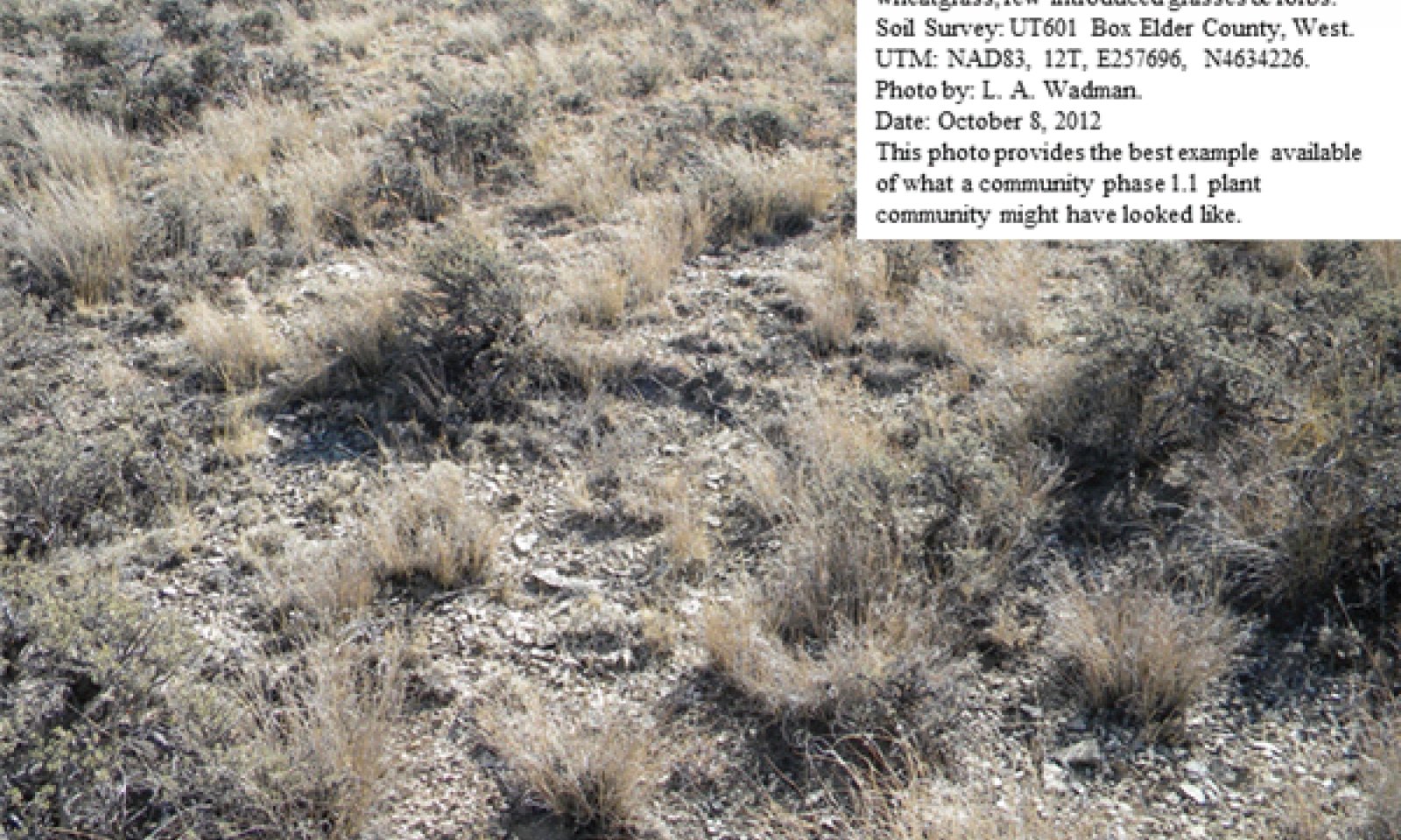
Black Sagebrush/Bluebunch Wheatgrass Community Phase
Figure 5. Community phase 1.1
This reference community phase is dominated by black sagebrush and bluebunch wheatgrass. Other significant shrubs include antelope bitterbrush and slender buckwheat. Other commonly occurring grasses include Nevada bluegrass and Indian ricegrass. This site is mature and may be nearing the end of its natural fire cycle. The sites vegetative composition by air-dry weight is approximately 40 percent perennial grasses, 15 percent forbs, and 45 percent shrubs. The following tables provide an example of the typical vegetative floristics of a community phase 1.1 plant community.
Figure 6. Annual production by plant type (representative values) or group (midpoint values)
Table 5. Annual production by plant type
Plant type Low
(lb/acre)Representative value
(lb/acre)High
(lb/acre)Grass/Grasslike 100 275 350 Shrub/Vine 150 250 350 Forb 50 75 100 Total 300 600 800 Table 6. Ground cover
Tree foliar cover 0% Shrub/vine/liana foliar cover 10-30% Grass/grasslike foliar cover 10-30% Forb foliar cover 10% Non-vascular plants 0% Biological crusts 0% Litter 0% Surface fragments >0.25" and <=3" 0% Surface fragments >3" 0% Bedrock 0% Water 0% Bare ground 0% Table 7. Canopy structure (% cover)
Height Above Ground (ft) Tree Shrub/Vine Grass/
GrasslikeForb <0.5 – – – – >0.5 <= 1 – – – 0-5% >1 <= 2 – 25-35% 25-30% – >2 <= 4.5 – – – – >4.5 <= 13 – – – – >13 <= 40 – – – – >40 <= 80 – – – – >80 <= 120 – – – – >120 – – – – Figure 7. Plant community growth curve (percent production by month). UT3181 , PNC. Excellent Condition.
Jan Feb Mar Apr May Jun Jul Aug Sep Oct Nov Dec J F M A M J J A S O N D 0 0 5 15 40 20 10 5 5 0 0 0 Community 1.2
Bluebunch Wheatgrass, Herbaceous Grass Community Phase
Figure 8. community phase 1.2
The visual aspect of this reference community phase is dominated by bluebunch wheatgrass and western wheatgrass. Significant shrubs are present and typically include black sagebrush, antelope bitterbrush and slender buckwheat. Other commonly occurring grasses include Nevada bluegrass and Indian ricegrass. This site is early in its natural fire cycle and a slow transition from herbaceous species to woody species is occurring. The sites vegetative composition by air-dry weight is approximately 55 percent perennial grasses, 10 percent forbs, and 35 percent shrubs. The following tables provide an example of the typical vegetative floristics of a community phase 1.2 plant community.
Figure 9. Annual production by plant type (representative values) or group (midpoint values)
Table 8. Annual production by plant type
Plant type Low
(lb/acre)Representative value
(lb/acre)High
(lb/acre)Grass/Grasslike 100 275 350 Shrub/Vine 150 250 350 Forb 50 75 100 Total 300 600 800 Table 9. Ground cover
Tree foliar cover 0% Shrub/vine/liana foliar cover 10-30% Grass/grasslike foliar cover 10-30% Forb foliar cover 10% Non-vascular plants 0% Biological crusts 0% Litter 0% Surface fragments >0.25" and <=3" 0% Surface fragments >3" 0% Bedrock 0% Water 0% Bare ground 0% Table 10. Canopy structure (% cover)
Height Above Ground (ft) Tree Shrub/Vine Grass/
GrasslikeForb <0.5 – – – – >0.5 <= 1 – – – 0-5% >1 <= 2 – 25-35% 25-30% – >2 <= 4.5 – – – – >4.5 <= 13 – – – – >13 <= 40 – – – – >40 <= 80 – – – – >80 <= 120 – – – – >120 – – – – Figure 10. Plant community growth curve (percent production by month). UT3181 , PNC. Excellent Condition.
Jan Feb Mar Apr May Jun Jul Aug Sep Oct Nov Dec J F M A M J J A S O N D 0 0 5 15 40 20 10 5 5 0 0 0 Pathway 1.1A
Community 1.1 to 1.2
Black Sagebrush/Bluebunch Wheatgrass Community Phase
Bluebunch Wheatgrass, Herbaceous Grass Community PhaseThis community pathway occurs when conditions favor an increase in native herbaceous species. A series of above average moisture years combined with excellent grazing management where the site is grazed can facilitate this shift to grasses and forbs. This pathway normally occurs in the early part of fire cycle (20 - 30 years).
Pathway 1.2A
Community 1.2 to 1.1
Bluebunch Wheatgrass, Herbaceous Grass Community Phase
Black Sagebrush/Bluebunch Wheatgrass Community PhaseThis community pathway occurs when fire is absent from the community for long periods of time. It usually is found near the end of the sites natural fire cycle (60 - 80 years). Drought periods and improper livestock grazing can facilitate this change in composition.
State 2
Current Potential StateThe Current Potential State is similar to the Reference Sate except that non-native species are now present. This state describes the plant communities that may or have become established on this ecological site under various successional sequences and disturbance conditions. This state typically has a well developed shrub layer with black sagebrush often dominating. Antelope bitterbrush and slender buckwheat are other common shrub species. Bluebunch wheatgrass is the dominant herbaceous species with Nevada bluegrass and other perennial grasses and forbs commonly found in abundance also. These other native grasses, forbs, and shrubs may produce significant composition in the plant community. Cheatgrass, alyssum, various mustard species and other non-native species are present on the site and under certain circumstances, may visually dominate the sites aspect.
The primary disturbance mechanisms are the shrub layer density; the amount of invasive species present; weather fluctuations; and fire. The current potential state is still self-sustaining but may be losing its resistance to change due to the impact of disturbances with less resilience following those disturbances.
Definitions:
Current Potential State: Plant communities influenced by shrub canopy density, long term weather fluctuations, and periodic fire. Invasive species are present in various amounts.
Indicators: A community dominated by black sagebrush and bluebunch wheatgrass. The density of the shrub canopy determines the amount and composition of the other native and introduced grasses and forbs that may be present.
Feedbacks: Natural fluctuations in weather patterns that allow for a self sustaining shrub and native grass community. Prolonged drought, more frequent fires, and/or other disturbances that may allow for the increase of invasive species.
At-risk Community Phase: All communities are at risk when native plants are stressed and nutrients become available for invasive plants to increase.
Trigger: A reduction of perennial grass and forb species combined with an increase of invasive plant species.Community 2.1
Black Sagebrush/Bluebunch Wheatgrass Invasive Weed Community Phase
Figure 11. community phase 2.1
This community phase is dominated by black sagebrush and bluebunch wheatgrass. Other significant shrubs include antelope bitterbrush and slender buckwheat. Other commonly occurring grasses include Nevada bluegrass and Indian ricegrass. Non-native species are now present in the all plant communities and are expected to remain a permanent part of these communities. The sites vegetative composition by air-dry weight is approximately 40 percent perennial grasses, 15 percent forbs, and 45 percent shrubs. The following tables provide an example of the typical vegetative floristics of a community phase 2.1 plant community.
Figure 12. Annual production by plant type (representative values) or group (midpoint values)
Table 11. Annual production by plant type
Plant type Low
(lb/acre)Representative value
(lb/acre)High
(lb/acre)Grass/Grasslike 100 275 350 Shrub/Vine 150 250 350 Forb 50 75 100 Total 300 600 800 Table 12. Ground cover
Tree foliar cover 0% Shrub/vine/liana foliar cover 10-30% Grass/grasslike foliar cover 10-30% Forb foliar cover 10% Non-vascular plants 0% Biological crusts 0% Litter 0% Surface fragments >0.25" and <=3" 0% Surface fragments >3" 0% Bedrock 0% Water 0% Bare ground 0% Table 13. Canopy structure (% cover)
Height Above Ground (ft) Tree Shrub/Vine Grass/
GrasslikeForb <0.5 – – – – >0.5 <= 1 – – – 0-5% >1 <= 2 – 25-35% 25-30% – >2 <= 4.5 – – – – >4.5 <= 13 – – – – >13 <= 40 – – – – >40 <= 80 – – – – >80 <= 120 – – – – >120 – – – – Figure 13. Plant community growth curve (percent production by month). UT3181 , PNC. Excellent Condition.
Jan Feb Mar Apr May Jun Jul Aug Sep Oct Nov Dec J F M A M J J A S O N D 0 0 5 15 40 20 10 5 5 0 0 0 Community 2.2
Black Sagebrush/ Invasive Weed Community Phase
Figure 14. community phase 2.2
This community phase is dominated by black sagebrush. Other shrubs, including antelope bitterbrush and slender buckwheat may or may not be present. Native perennial grasses are much reduced or missing from the herbaceous layer. Nevada and Sandberg bluegrasses may still be present but at reduced levels. Non-native species are now present in the all plant communities and may dominate the community. The lack of fire extends well beyond the normal period for the site. Utah juniper seedlings and saplings may begin invading the community if a seed source is available. The sites vegetative composition by air-dry weight is approximately 25 percent grasses and introduced weedy species, 10 percent forbs, and 65 percent shrubs. The following tables provide an example of the typical vegetative floristics of a community phase 2.2 plant community.
Figure 15. Annual production by plant type (representative values) or group (midpoint values)
Table 14. Annual production by plant type
Plant type Low
(lb/acre)Representative value
(lb/acre)High
(lb/acre)Grass/Grasslike 100 275 350 Shrub/Vine 150 250 350 Forb 50 75 100 Total 300 600 800 Table 15. Ground cover
Tree foliar cover 0% Shrub/vine/liana foliar cover 10-30% Grass/grasslike foliar cover 10-30% Forb foliar cover 10% Non-vascular plants 0% Biological crusts 0% Litter 0% Surface fragments >0.25" and <=3" 0% Surface fragments >3" 0% Bedrock 0% Water 0% Bare ground 0% Table 16. Canopy structure (% cover)
Height Above Ground (ft) Tree Shrub/Vine Grass/
GrasslikeForb <0.5 – – – – >0.5 <= 1 – – – 0-5% >1 <= 2 – 25-35% 25-30% – >2 <= 4.5 – – – – >4.5 <= 13 – – – – >13 <= 40 – – – – >40 <= 80 – – – – >80 <= 120 – – – – >120 – – – – Figure 16. Plant community growth curve (percent production by month). UT3181 , PNC. Excellent Condition.
Jan Feb Mar Apr May Jun Jul Aug Sep Oct Nov Dec J F M A M J J A S O N D 0 0 5 15 40 20 10 5 5 0 0 0 Pathway 2.1A
Community 2.1 to 2.2
Black Sagebrush/Bluebunch Wheatgrass Invasive Weed Community Phase
Black Sagebrush/ Invasive Weed Community PhaseThis community pathway occurs when fire is absent from the community for long periods of time. It usually is found near the end of the sites natural fire cycle (60 - 80 years). Drought periods and improper livestock grazing can facilitate this change in composition.
Pathway 2.2A
Community 2.2 to 2.1
Black Sagebrush/ Invasive Weed Community Phase
Black Sagebrush/Bluebunch Wheatgrass Invasive Weed Community PhaseThis community pathway occurs when conditions favor an increase in native herbaceous species. A series of above average moisture years combined with excellent grazing management where the site is grazed can facilitate this shift to grasses and forbs. This pathway normally occurs in the early part of fire cycle (20 - 30 years). Where there is not sufficient desirable perennial vegetation present or black sagebrush is to dense to allow for a natural recovery to take place, spraying the sagebrush followed by range seeding can facilitate this change.
State 3
Juniper Invasion/Non-native Weed StateThe Juniper Invasion/Invasive Weed State is similar to the Current Potential State except that Utah juniper along with various non-native species is now present. This state describes the plant communities that may or have become established on this ecological site under various successional sequences and disturbance conditions. This state is dominated by Utah juniper and typically has a well developed shrub layer as well, with black sagebrush often dominating. Antelope bitterbrush and slender buckwheat are much reduced or may not be present. Bluebunch wheatgrass and other native perennial grass species are also reduced or missing from the herbaceous layer. Nevada bluegrass is usually still present and along with invasive weedy species, including cheatgrass, alyssum, various mustard species and other non-native species, may visually dominate the sites herbaceous layer.
The primary disturbance mechanisms include an overstory of Utah juniper; a shrub layer comprised of various amounts of black sagebrush; significant amounts of invasive herbaceous species present; weather fluctuations, and fire patterns. This state is losing its resistance to change due to the impact of these disturbances and has less resilience following those disturbances.
Definitions:
Juniper Invasion State: Plant communities dominated by an overstory of Utah juniper; a shrub canopy typically composed of black sagebrush of various densities; long term weather fluctuations; and periodic fire.
Indicators: The density of the tree and shrub canopies determines the amount and composition of the other native and introduced grasses and forbs that may be present.
Feedbacks: Natural fluctuations in weather patterns that allow Utah juniper to invade and impact the native shrub and grass communities. Prolonged drought, less frequent fire, and/or other disturbances that allow for the increase of all invasive species.
At-risk Community Phase: All communities are at risk when native plants are stressed and nutrients become available for invasive plants to increase.
Trigger: A reduction of perennial grass and forb species combined with an increase of invasive plant species.Community 3.1
Utah Juniper/ Invasive Weed Community Phase
Figure 17. community phase 3.1
This community phase is dominated by an overstory of Utah juniper. Black sagebrush is present in varying amounts. Antelope bitterbrush and slender buckwheat may or may not be present. Native perennial grasses are much reduced or missing from the herbaceous layer. Sandberg and some Nevada bluegrass may still be present but at reduced levels. Non-native species are now present in the all plant communities and may dominate the community. The occurrence of fire extends well beyond the normal period for the site. Mature Utah juniper, along with seedlings and saplings are present in the community. The sites vegetative composition by air-dry weight is approximately 25 percent grasses and introduced weedy species, 10 percent forbs, 50 percent shrubs and 15% trees. The following tables provide an example of the typical vegetative floristics of a community phase 3.1 plant community.
Figure 18. Annual production by plant type (representative values) or group (midpoint values)
Table 17. Annual production by plant type
Plant type Low
(lb/acre)Representative value
(lb/acre)High
(lb/acre)Grass/Grasslike 100 275 350 Shrub/Vine 150 250 350 Forb 50 75 100 Total 300 600 800 Table 18. Ground cover
Tree foliar cover 0% Shrub/vine/liana foliar cover 10-30% Grass/grasslike foliar cover 10-30% Forb foliar cover 10% Non-vascular plants 0% Biological crusts 0% Litter 0% Surface fragments >0.25" and <=3" 0% Surface fragments >3" 0% Bedrock 0% Water 0% Bare ground 0% Table 19. Canopy structure (% cover)
Height Above Ground (ft) Tree Shrub/Vine Grass/
GrasslikeForb <0.5 – – – – >0.5 <= 1 – – – 0-5% >1 <= 2 – 25-35% 25-30% – >2 <= 4.5 – – – – >4.5 <= 13 – – – – >13 <= 40 – – – – >40 <= 80 – – – – >80 <= 120 – – – – >120 – – – – Figure 19. Plant community growth curve (percent production by month). UT3181 , PNC. Excellent Condition.
Jan Feb Mar Apr May Jun Jul Aug Sep Oct Nov Dec J F M A M J J A S O N D 0 0 5 15 40 20 10 5 5 0 0 0 Community 3.2
Chained & Seeded Community Phase
Figure 20. community phase 3.2
Site has been mechanically chained or pushed to remove the overstory Utah juniper. Black sagebrush is present in varying amounts. Antelope bitterbrush and slender buckwheat may or may not be present. Native perennial grasses are much reduced or missing from the herbaceous layer. The site is typically seeded to crested or intermediate wheatgrass. Various amounts of native grasses and forbs may still be present but at reduced levels. Non-native species are present on the site and will be present in the seeded community. Utah juniper seedlings are also typically present in the chained community and may need follow-up treatment. The sites vegetative composition by air-dry weight is approximately 55 percent grasses and introduced weedy species, 10 percent forbs, 30 percent shrubs and 5% trees. The following tables provide an example of the typical vegetative floristics of a community phase 3.2 plant community.
Figure 21. Annual production by plant type (representative values) or group (midpoint values)
Table 20. Annual production by plant type
Plant type Low
(lb/acre)Representative value
(lb/acre)High
(lb/acre)Grass/Grasslike 100 275 350 Shrub/Vine 150 250 350 Forb 50 75 100 Total 300 600 800 Table 21. Ground cover
Tree foliar cover 0% Shrub/vine/liana foliar cover 10-30% Grass/grasslike foliar cover 10-30% Forb foliar cover 10% Non-vascular plants 0% Biological crusts 0% Litter 0% Surface fragments >0.25" and <=3" 0% Surface fragments >3" 0% Bedrock 0% Water 0% Bare ground 0% Table 22. Canopy structure (% cover)
Height Above Ground (ft) Tree Shrub/Vine Grass/
GrasslikeForb <0.5 – – – – >0.5 <= 1 – – – 0-5% >1 <= 2 – 25-35% 25-30% – >2 <= 4.5 – – – – >4.5 <= 13 – – – – >13 <= 40 – – – – >40 <= 80 – – – – >80 <= 120 – – – – >120 – – – – Figure 22. Plant community growth curve (percent production by month). UT3181 , PNC. Excellent Condition.
Jan Feb Mar Apr May Jun Jul Aug Sep Oct Nov Dec J F M A M J J A S O N D 0 0 5 15 40 20 10 5 5 0 0 0 Pathway 3.1A
Community 3.1 to 3.2
Utah Juniper/ Invasive Weed Community Phase
Chained & Seeded Community PhaseThis community phase occurs when the site is mechanically chained or pushed to remove Utah juniper. It is then typically seeded to adapted forage species such as crested or intermediate wheatgrass. Proper grazing management is needed to allow for good site recovery.
Pathway 3.2A
Community 3.2 to 3.1
Chained & Seeded Community Phase
Utah Juniper/ Invasive Weed Community PhaseThis community pathway can occur when the site is improperly grazed following treatment. Drought periods can facilitate this change in vegetative composition. The lack of fire can allow Utah juniper and basin big sagebrush to increase during these periods until they can again dominate the community.
Transition T1A
State 1 to 2This transitional pathway occurs when any combination of drought and a lack of fire allow non-native, invasive species to occupy the site. Improper livestock grazing can stress the community by decreasing palatable perennial grasses and forbs, creating areas for these species to become well established. Once non-native species such as cheatgrass, alyssum, Russian thistle, etc. are present, a threshold has been crossed.
Transition T2A
State 2 to 3This transitional pathway occurs when extended drought and a lack of fire to allow Utah juniper along with non-native, invasive species to fully occupy the site. Improper livestock grazing can add additional stress the community by decreasing palatable perennial grasses and forbs, creating areas for these species to become well established.
Additional community tables
Table 23. Community 1.1 plant community composition
Group Common name Symbol Scientific name Annual production () Foliar cover (%) Grass/Grasslike1 Primary Grasses 250–300 bluebunch wheatgrass PSSP6 Pseudoroegneria spicata 200–250 – 4 Secondary Grasses 30–50 Indian ricegrass ACHY Achnatherum hymenoides 30–50 – Letterman's needlegrass ACLE9 Achnatherum lettermanii 20–40 – Geyer's sedge CAGE2 Carex geyeri 20–40 – squirreltail ELEL5 Elymus elymoides 20–40 – needle and thread HECO26 Hesperostipa comata 20–40 – western wheatgrass PASM Pascopyrum smithii 20–40 – muttongrass POFE Poa fendleriana 20–40 – Sandberg bluegrass POSE Poa secunda 20–40 – Grass, perennial 2GP Grass, perennial 20–40 – Forb2 Forbs 100–150 Forb, annual 2FA Forb, annual 30–50 – Forb, perennial 2FP Forb, perennial 30–50 – common yarrow ACMI2 Achillea millefolium 30–50 – Brandegee's onion ALBR Allium brandegeei 30–50 – Nevada onion ALNE Allium nevadense 30–50 – low pussytoes ANDI2 Antennaria dimorpha 30–50 – Torrey's milkvetch ASCA9 Astragalus calycosus 30–50 – freckled milkvetch ASLE8 Astragalus lentiginosus 30–50 – woolly locoweed ASMO7 Astragalus mollissimus 30–50 – plains milkweed ASPU Asclepias pumila 30–50 – Hooker's balsamroot BAHO Balsamorhiza hookeri 30–50 – northwestern Indian paintbrush CAAN7 Castilleja angustifolia 30–50 – maiden blue eyed Mary COPA3 Collinsia parviflora 30–50 – bastard toadflax COUM Comandra umbellata 30–50 – tapertip hawksbeard CRAC2 Crepis acuminata 30–50 – twolobe larkspur DENU2 Delphinium nuttallianum 30–50 – tall annual willowherb EPBR3 Epilobium brachycarpum 30–50 – shortstem buckwheat ERBR5 Eriogonum brevicaule 30–50 – western stoneseed LIRU4 Lithospermum ruderale 30–50 – tailcup lupine LUCAC3 Lupinus caudatus ssp. caudatus 30–50 – hoary tansyaster MACA2 Machaeranthera canescens 30–50 – pale evening primrose OEPA Oenothera pallida 30–50 – plains pricklypear OPPO Opuntia polyacantha 30–50 – Tolmie's owl's-clover ORTO Orthocarpus tolmiei 30–50 – spiny phlox PHHO Phlox hoodii 30–50 – longleaf phlox PHLO2 Phlox longifolia 30–50 – yellow salsify TRDU Tragopogon dubius 30–50 – salsify TRPO Tragopogon porrifolius 30–50 – American vetch VIAM Vicia americana 30–50 – Shrub/Vine3 Primary Shrubs 275–325 black sagebrush ARNO4 Artemisia nova 200–250 – slender buckwheat ERMI4 Eriogonum microthecum 30–50 – 5 Secondary Shrubs 30–50 Shrub (>.5m) 2SHRUB Shrub (>.5m) 20–30 – shadscale saltbush ATCO Atriplex confertifolia 20–30 – curl-leaf mountain mahogany CELE3 Cercocarpus ledifolius 20–30 – alderleaf mountain mahogany CEMO2 Cercocarpus montanus 20–30 – yellow rabbitbrush CHVI8 Chrysothamnus viscidiflorus 20–30 – Nevada jointfir EPNE Ephedra nevadensis 20–30 – slender buckwheat ERMI4 Eriogonum microthecum 20–30 – rubber rabbitbrush ERNA10 Ericameria nauseosa 20–30 – spiny hopsage GRSP Grayia spinosa 20–30 – broom snakeweed GUSA2 Gutierrezia sarothrae 20–30 – winterfat KRLA2 Krascheninnikovia lanata 20–30 – plains pricklypear OPPO Opuntia polyacantha 20–30 – antelope bitterbrush PUTR2 Purshia tridentata 20–30 – mountain snowberry SYOR2 Symphoricarpos oreophilus 20–30 – spineless horsebrush TECA2 Tetradymia canescens 20–30 – Table 24. Community 1.2 plant community composition
Group Common name Symbol Scientific name Annual production () Foliar cover (%) Grass/Grasslike1 Primary Grasses 350–400 bluebunch wheatgrass PSSP6 Pseudoroegneria spicata 300–350 – 4 Secondary Grasses 30–50 Indian ricegrass ACHY Achnatherum hymenoides 30–50 – Letterman's needlegrass ACLE9 Achnatherum lettermanii 20–40 – Geyer's sedge CAGE2 Carex geyeri 20–40 – squirreltail ELEL5 Elymus elymoides 20–40 – needle and thread HECO26 Hesperostipa comata 20–40 – western wheatgrass PASM Pascopyrum smithii 20–40 – muttongrass POFE Poa fendleriana 20–40 – Sandberg bluegrass POSE Poa secunda 20–40 – Grass, perennial 2GP Grass, perennial 20–40 – Forb2 Forbs 100–150 Forb, annual 2FA Forb, annual 30–50 – Forb, perennial 2FP Forb, perennial 30–50 – common yarrow ACMI2 Achillea millefolium 30–50 – Brandegee's onion ALBR Allium brandegeei 30–50 – Nevada onion ALNE Allium nevadense 30–50 – low pussytoes ANDI2 Antennaria dimorpha 30–50 – Torrey's milkvetch ASCA9 Astragalus calycosus 30–50 – freckled milkvetch ASLE8 Astragalus lentiginosus 30–50 – woolly locoweed ASMO7 Astragalus mollissimus 30–50 – plains milkweed ASPU Asclepias pumila 30–50 – Hooker's balsamroot BAHO Balsamorhiza hookeri 30–50 – northwestern Indian paintbrush CAAN7 Castilleja angustifolia 30–50 – maiden blue eyed Mary COPA3 Collinsia parviflora 30–50 – bastard toadflax COUM Comandra umbellata 30–50 – tapertip hawksbeard CRAC2 Crepis acuminata 30–50 – twolobe larkspur DENU2 Delphinium nuttallianum 30–50 – tall annual willowherb EPBR3 Epilobium brachycarpum 30–50 – shortstem buckwheat ERBR5 Eriogonum brevicaule 30–50 – western stoneseed LIRU4 Lithospermum ruderale 30–50 – tailcup lupine LUCAC3 Lupinus caudatus ssp. caudatus 30–50 – hoary tansyaster MACA2 Machaeranthera canescens 30–50 – pale evening primrose OEPA Oenothera pallida 30–50 – plains pricklypear OPPO Opuntia polyacantha 30–50 – Tolmie's owl's-clover ORTO Orthocarpus tolmiei 30–50 – spiny phlox PHHO Phlox hoodii 30–50 – longleaf phlox PHLO2 Phlox longifolia 30–50 – yellow salsify TRDU Tragopogon dubius 30–50 – salsify TRPO Tragopogon porrifolius 30–50 – American vetch VIAM Vicia americana 30–50 – Shrub/Vine3 Primary Shrubs 200–275 black sagebrush ARNO4 Artemisia nova 100–150 – slender buckwheat ERMI4 Eriogonum microthecum 30–50 – 5 Secondary Shrubs 30–50 Shrub (>.5m) 2SHRUB Shrub (>.5m) 20–30 – shadscale saltbush ATCO Atriplex confertifolia 20–30 – curl-leaf mountain mahogany CELE3 Cercocarpus ledifolius 20–30 – alderleaf mountain mahogany CEMO2 Cercocarpus montanus 20–30 – yellow rabbitbrush CHVI8 Chrysothamnus viscidiflorus 20–30 – Nevada jointfir EPNE Ephedra nevadensis 20–30 – slender buckwheat ERMI4 Eriogonum microthecum 20–30 – rubber rabbitbrush ERNA10 Ericameria nauseosa 20–30 – spiny hopsage GRSP Grayia spinosa 20–30 – broom snakeweed GUSA2 Gutierrezia sarothrae 20–30 – winterfat KRLA2 Krascheninnikovia lanata 20–30 – plains pricklypear OPPO Opuntia polyacantha 20–30 – antelope bitterbrush PUTR2 Purshia tridentata 20–30 – mountain snowberry SYOR2 Symphoricarpos oreophilus 20–30 – spineless horsebrush TECA2 Tetradymia canescens 20–30 – Table 25. Community 2.1 plant community composition
Group Common name Symbol Scientific name Annual production () Foliar cover (%) Grass/Grasslike1 Primary Grasses 250–300 bluebunch wheatgrass PSSP6 Pseudoroegneria spicata 200–250 – cheatgrass BRTE Bromus tectorum 30–50 – bulbous bluegrass POBU Poa bulbosa 30–50 – 4 Secondary Grasses 30–50 Indian ricegrass ACHY Achnatherum hymenoides 30–50 – Letterman's needlegrass ACLE9 Achnatherum lettermanii 20–40 – Geyer's sedge CAGE2 Carex geyeri 20–40 – squirreltail ELEL5 Elymus elymoides 20–40 – needle and thread HECO26 Hesperostipa comata 20–40 – western wheatgrass PASM Pascopyrum smithii 20–40 – muttongrass POFE Poa fendleriana 20–40 – Sandberg bluegrass POSE Poa secunda 20–40 – Grass, perennial 2GP Grass, perennial 20–40 – Forb2 Forbs 100–150 Forb, annual 2FA Forb, annual 30–50 – Forb, perennial 2FP Forb, perennial 30–50 – common yarrow ACMI2 Achillea millefolium 30–50 – Brandegee's onion ALBR Allium brandegeei 30–50 – Nevada onion ALNE Allium nevadense 30–50 – low pussytoes ANDI2 Antennaria dimorpha 30–50 – Torrey's milkvetch ASCA9 Astragalus calycosus 30–50 – freckled milkvetch ASLE8 Astragalus lentiginosus 30–50 – woolly locoweed ASMO7 Astragalus mollissimus 30–50 – plains milkweed ASPU Asclepias pumila 30–50 – Hooker's balsamroot BAHO Balsamorhiza hookeri 30–50 – northwestern Indian paintbrush CAAN7 Castilleja angustifolia 30–50 – crossflower CHTE2 Chorispora tenella 30–50 – maiden blue eyed Mary COPA3 Collinsia parviflora 30–50 – bastard toadflax COUM Comandra umbellata 30–50 – tapertip hawksbeard CRAC2 Crepis acuminata 30–50 – twolobe larkspur DENU2 Delphinium nuttallianum 30–50 – herb sophia DESO2 Descurainia sophia 30–50 – tall annual willowherb EPBR3 Epilobium brachycarpum 30–50 – shortstem buckwheat ERBR5 Eriogonum brevicaule 30–50 – common sunflower HEAN3 Helianthus annuus 30–50 – prickly lettuce LASE Lactuca serriola 30–50 – western stoneseed LIRU4 Lithospermum ruderale 30–50 – tailcup lupine LUCAC3 Lupinus caudatus ssp. caudatus 30–50 – hoary tansyaster MACA2 Machaeranthera canescens 30–50 – pale evening primrose OEPA Oenothera pallida 30–50 – plains pricklypear OPPO Opuntia polyacantha 30–50 – Tolmie's owl's-clover ORTO Orthocarpus tolmiei 30–50 – spiny phlox PHHO Phlox hoodii 30–50 – longleaf phlox PHLO2 Phlox longifolia 30–50 – Russian thistle SAKA Salsola kali 30–50 – tall tumblemustard SIAL2 Sisymbrium altissimum 30–50 – yellow salsify TRDU Tragopogon dubius 30–50 – salsify TRPO Tragopogon porrifolius 30–50 – American vetch VIAM Vicia americana 30–50 – Shrub/Vine3 Primary Shrubs 275–325 black sagebrush ARNO4 Artemisia nova 200–250 – slender buckwheat ERMI4 Eriogonum microthecum 30–50 – 5 Secondary Shrubs 30–50 Shrub (>.5m) 2SHRUB Shrub (>.5m) 20–30 – shadscale saltbush ATCO Atriplex confertifolia 20–30 – curl-leaf mountain mahogany CELE3 Cercocarpus ledifolius 20–30 – alderleaf mountain mahogany CEMO2 Cercocarpus montanus 20–30 – yellow rabbitbrush CHVI8 Chrysothamnus viscidiflorus 20–30 – Nevada jointfir EPNE Ephedra nevadensis 20–30 – slender buckwheat ERMI4 Eriogonum microthecum 20–30 – rubber rabbitbrush ERNA10 Ericameria nauseosa 20–30 – spiny hopsage GRSP Grayia spinosa 20–30 – broom snakeweed GUSA2 Gutierrezia sarothrae 20–30 – winterfat KRLA2 Krascheninnikovia lanata 20–30 – plains pricklypear OPPO Opuntia polyacantha 20–30 – antelope bitterbrush PUTR2 Purshia tridentata 20–30 – mountain snowberry SYOR2 Symphoricarpos oreophilus 20–30 – spineless horsebrush TECA2 Tetradymia canescens 20–30 – Table 26. Community 2.2 plant community composition
Group Common name Symbol Scientific name Annual production () Foliar cover (%) Grass/Grasslike1 Primary Grasses 250–300 cheatgrass BRTE Bromus tectorum 100–150 – bulbous bluegrass POBU Poa bulbosa 100–150 – bluebunch wheatgrass PSSP6 Pseudoroegneria spicata 50–100 – 4 Secondary Grasses 30–50 Indian ricegrass ACHY Achnatherum hymenoides 30–50 – Letterman's needlegrass ACLE9 Achnatherum lettermanii 20–40 – Geyer's sedge CAGE2 Carex geyeri 20–40 – squirreltail ELEL5 Elymus elymoides 20–40 – needle and thread HECO26 Hesperostipa comata 20–40 – western wheatgrass PASM Pascopyrum smithii 20–40 – muttongrass POFE Poa fendleriana 20–40 – Sandberg bluegrass POSE Poa secunda 20–40 – Grass, perennial 2GP Grass, perennial 20–40 – Forb2 Forbs 100–150 Forb, annual 2FA Forb, annual 30–50 – Forb, perennial 2FP Forb, perennial 30–50 – common yarrow ACMI2 Achillea millefolium 30–50 – Brandegee's onion ALBR Allium brandegeei 30–50 – Nevada onion ALNE Allium nevadense 30–50 – low pussytoes ANDI2 Antennaria dimorpha 30–50 – Torrey's milkvetch ASCA9 Astragalus calycosus 30–50 – freckled milkvetch ASLE8 Astragalus lentiginosus 30–50 – woolly locoweed ASMO7 Astragalus mollissimus 30–50 – plains milkweed ASPU Asclepias pumila 30–50 – Hooker's balsamroot BAHO Balsamorhiza hookeri 30–50 – northwestern Indian paintbrush CAAN7 Castilleja angustifolia 30–50 – crossflower CHTE2 Chorispora tenella 30–50 – maiden blue eyed Mary COPA3 Collinsia parviflora 30–50 – bastard toadflax COUM Comandra umbellata 30–50 – tapertip hawksbeard CRAC2 Crepis acuminata 30–50 – twolobe larkspur DENU2 Delphinium nuttallianum 30–50 – herb sophia DESO2 Descurainia sophia 30–50 – tall annual willowherb EPBR3 Epilobium brachycarpum 30–50 – shortstem buckwheat ERBR5 Eriogonum brevicaule 30–50 – common sunflower HEAN3 Helianthus annuus 30–50 – prickly lettuce LASE Lactuca serriola 30–50 – western stoneseed LIRU4 Lithospermum ruderale 30–50 – tailcup lupine LUCAC3 Lupinus caudatus ssp. caudatus 30–50 – hoary tansyaster MACA2 Machaeranthera canescens 30–50 – pale evening primrose OEPA Oenothera pallida 30–50 – plains pricklypear OPPO Opuntia polyacantha 30–50 – Tolmie's owl's-clover ORTO Orthocarpus tolmiei 30–50 – spiny phlox PHHO Phlox hoodii 30–50 – longleaf phlox PHLO2 Phlox longifolia 30–50 – Russian thistle SAKA Salsola kali 30–50 – tall tumblemustard SIAL2 Sisymbrium altissimum 30–50 – yellow salsify TRDU Tragopogon dubius 30–50 – salsify TRPO Tragopogon porrifolius 30–50 – American vetch VIAM Vicia americana 30–50 – Shrub/Vine3 Primary Shrubs 275–325 black sagebrush ARNO4 Artemisia nova 200–250 – slender buckwheat ERMI4 Eriogonum microthecum 30–50 – 5 Secondary Shrubs 30–50 Shrub (>.5m) 2SHRUB Shrub (>.5m) 20–30 – shadscale saltbush ATCO Atriplex confertifolia 20–30 – curl-leaf mountain mahogany CELE3 Cercocarpus ledifolius 20–30 – alderleaf mountain mahogany CEMO2 Cercocarpus montanus 20–30 – yellow rabbitbrush CHVI8 Chrysothamnus viscidiflorus 20–30 – Nevada jointfir EPNE Ephedra nevadensis 20–30 – slender buckwheat ERMI4 Eriogonum microthecum 20–30 – rubber rabbitbrush ERNA10 Ericameria nauseosa 20–30 – spiny hopsage GRSP Grayia spinosa 20–30 – broom snakeweed GUSA2 Gutierrezia sarothrae 20–30 – winterfat KRLA2 Krascheninnikovia lanata 20–30 – plains pricklypear OPPO Opuntia polyacantha 20–30 – antelope bitterbrush PUTR2 Purshia tridentata 20–30 – mountain snowberry SYOR2 Symphoricarpos oreophilus 20–30 – spineless horsebrush TECA2 Tetradymia canescens 20–30 – Table 27. Community 3.1 plant community composition
Group Common name Symbol Scientific name Annual production () Foliar cover (%) Grass/Grasslike1 Primary Grasses 250–300 cheatgrass BRTE Bromus tectorum 100–150 – bulbous bluegrass POBU Poa bulbosa 100–150 – bluebunch wheatgrass PSSP6 Pseudoroegneria spicata 50–100 – 4 Secondary Grasses 30–50 Indian ricegrass ACHY Achnatherum hymenoides 30–50 – Letterman's needlegrass ACLE9 Achnatherum lettermanii 20–40 – Geyer's sedge CAGE2 Carex geyeri 20–40 – squirreltail ELEL5 Elymus elymoides 20–40 – needle and thread HECO26 Hesperostipa comata 20–40 – western wheatgrass PASM Pascopyrum smithii 20–40 – muttongrass POFE Poa fendleriana 20–40 – Sandberg bluegrass POSE Poa secunda 20–40 – Grass, perennial 2GP Grass, perennial 20–40 – Forb2 Forbs 100–150 common yarrow ACMI2 Achillea millefolium 30–50 – Brandegee's onion ALBR Allium brandegeei 30–50 – Nevada onion ALNE Allium nevadense 30–50 – low pussytoes ANDI2 Antennaria dimorpha 30–50 – Torrey's milkvetch ASCA9 Astragalus calycosus 30–50 – freckled milkvetch ASLE8 Astragalus lentiginosus 30–50 – woolly locoweed ASMO7 Astragalus mollissimus 30–50 – plains milkweed ASPU Asclepias pumila 30–50 – Hooker's balsamroot BAHO Balsamorhiza hookeri 30–50 – northwestern Indian paintbrush CAAN7 Castilleja angustifolia 30–50 – crossflower CHTE2 Chorispora tenella 30–50 – maiden blue eyed Mary COPA3 Collinsia parviflora 30–50 – bastard toadflax COUM Comandra umbellata 30–50 – tapertip hawksbeard CRAC2 Crepis acuminata 30–50 – twolobe larkspur DENU2 Delphinium nuttallianum 30–50 – herb sophia DESO2 Descurainia sophia 30–50 – tall annual willowherb EPBR3 Epilobium brachycarpum 30–50 – shortstem buckwheat ERBR5 Eriogonum brevicaule 30–50 – common sunflower HEAN3 Helianthus annuus 30–50 – prickly lettuce LASE Lactuca serriola 30–50 – western stoneseed LIRU4 Lithospermum ruderale 30–50 – tailcup lupine LUCAC3 Lupinus caudatus ssp. caudatus 30–50 – hoary tansyaster MACA2 Machaeranthera canescens 30–50 – pale evening primrose OEPA Oenothera pallida 30–50 – plains pricklypear OPPO Opuntia polyacantha 30–50 – Tolmie's owl's-clover ORTO Orthocarpus tolmiei 30–50 – spiny phlox PHHO Phlox hoodii 30–50 – longleaf phlox PHLO2 Phlox longifolia 30–50 – Russian thistle SAKA Salsola kali 30–50 – tall tumblemustard SIAL2 Sisymbrium altissimum 30–50 – yellow salsify TRDU Tragopogon dubius 30–50 – salsify TRPO Tragopogon porrifolius 30–50 – American vetch VIAM Vicia americana 30–50 – Forb, annual 2FA Forb, annual 20–40 – Forb, perennial 2FP Forb, perennial 20–40 – Shrub/Vine3 Primary Shrubs 275–325 black sagebrush ARNO4 Artemisia nova 200–250 – slender buckwheat ERMI4 Eriogonum microthecum 30–50 – 5 Secondary Shrubs 30–50 Shrub (>.5m) 2SHRUB Shrub (>.5m) 20–30 – shadscale saltbush ATCO Atriplex confertifolia 20–30 – curl-leaf mountain mahogany CELE3 Cercocarpus ledifolius 20–30 – alderleaf mountain mahogany CEMO2 Cercocarpus montanus 20–30 – yellow rabbitbrush CHVI8 Chrysothamnus viscidiflorus 20–30 – Nevada jointfir EPNE Ephedra nevadensis 20–30 – slender buckwheat ERMI4 Eriogonum microthecum 20–30 – rubber rabbitbrush ERNA10 Ericameria nauseosa 20–30 – spiny hopsage GRSP Grayia spinosa 20–30 – broom snakeweed GUSA2 Gutierrezia sarothrae 20–30 – winterfat KRLA2 Krascheninnikovia lanata 20–30 – plains pricklypear OPPO Opuntia polyacantha 20–30 – antelope bitterbrush PUTR2 Purshia tridentata 20–30 – mountain snowberry SYOR2 Symphoricarpos oreophilus 20–30 – spineless horsebrush TECA2 Tetradymia canescens 20–30 – Tree6 Trees 300–400 Utah juniper JUOS Juniperus osteosperma 300–400 – Table 28. Community 3.2 plant community composition
Group Common name Symbol Scientific name Annual production () Foliar cover (%) Grass/Grasslike1 Primary Grasses 250–300 crested wheatgrass AGCR Agropyron cristatum 300–400 – intermediate wheatgrass THIN6 Thinopyrum intermedium 300–400 – cheatgrass BRTE Bromus tectorum 50–100 – bulbous bluegrass POBU Poa bulbosa 50–100 – bluebunch wheatgrass PSSP6 Pseudoroegneria spicata 50–100 – 4 Secondary Grasses 30–50 Indian ricegrass ACHY Achnatherum hymenoides 30–50 – Letterman's needlegrass ACLE9 Achnatherum lettermanii 20–40 – Geyer's sedge CAGE2 Carex geyeri 20–40 – squirreltail ELEL5 Elymus elymoides 20–40 – needle and thread HECO26 Hesperostipa comata 20–40 – western wheatgrass PASM Pascopyrum smithii 20–40 – muttongrass POFE Poa fendleriana 20–40 – Sandberg bluegrass POSE Poa secunda 20–40 – Grass, perennial 2GP Grass, perennial 20–40 – Forb2 Forbs 100–150 Forb, annual 2FA Forb, annual 30–50 – Forb, perennial 2FP Forb, perennial 30–50 – common yarrow ACMI2 Achillea millefolium 30–50 – Brandegee's onion ALBR Allium brandegeei 30–50 – Nevada onion ALNE Allium nevadense 30–50 – low pussytoes ANDI2 Antennaria dimorpha 30–50 – Torrey's milkvetch ASCA9 Astragalus calycosus 30–50 – freckled milkvetch ASLE8 Astragalus lentiginosus 30–50 – woolly locoweed ASMO7 Astragalus mollissimus 30–50 – plains milkweed ASPU Asclepias pumila 30–50 – Hooker's balsamroot BAHO Balsamorhiza hookeri 30–50 – northwestern Indian paintbrush CAAN7 Castilleja angustifolia 30–50 – crossflower CHTE2 Chorispora tenella 30–50 – maiden blue eyed Mary COPA3 Collinsia parviflora 30–50 – bastard toadflax COUM Comandra umbellata 30–50 – tapertip hawksbeard CRAC2 Crepis acuminata 30–50 – twolobe larkspur DENU2 Delphinium nuttallianum 30–50 – herb sophia DESO2 Descurainia sophia 30–50 – tall annual willowherb EPBR3 Epilobium brachycarpum 30–50 – shortstem buckwheat ERBR5 Eriogonum brevicaule 30–50 – common sunflower HEAN3 Helianthus annuus 30–50 – prickly lettuce LASE Lactuca serriola 30–50 – western stoneseed LIRU4 Lithospermum ruderale 30–50 – tailcup lupine LUCAC3 Lupinus caudatus ssp. caudatus 30–50 – hoary tansyaster MACA2 Machaeranthera canescens 30–50 – pale evening primrose OEPA Oenothera pallida 30–50 – plains pricklypear OPPO Opuntia polyacantha 30–50 – Tolmie's owl's-clover ORTO Orthocarpus tolmiei 30–50 – spiny phlox PHHO Phlox hoodii 30–50 – longleaf phlox PHLO2 Phlox longifolia 30–50 – Russian thistle SAKA Salsola kali 30–50 – tall tumblemustard SIAL2 Sisymbrium altissimum 30–50 – yellow salsify TRDU Tragopogon dubius 30–50 – salsify TRPO Tragopogon porrifolius 30–50 – American vetch VIAM Vicia americana 30–50 – Shrub/Vine3 Primary Shrubs 275–325 black sagebrush ARNO4 Artemisia nova 200–250 – slender buckwheat ERMI4 Eriogonum microthecum 30–50 – 5 Secondary Shrubs 30–50 Shrub (>.5m) 2SHRUB Shrub (>.5m) 20–30 – shadscale saltbush ATCO Atriplex confertifolia 20–30 – curl-leaf mountain mahogany CELE3 Cercocarpus ledifolius 20–30 – alderleaf mountain mahogany CEMO2 Cercocarpus montanus 20–30 – yellow rabbitbrush CHVI8 Chrysothamnus viscidiflorus 20–30 – Nevada jointfir EPNE Ephedra nevadensis 20–30 – slender buckwheat ERMI4 Eriogonum microthecum 20–30 – rubber rabbitbrush ERNA10 Ericameria nauseosa 20–30 – spiny hopsage GRSP Grayia spinosa 20–30 – broom snakeweed GUSA2 Gutierrezia sarothrae 20–30 – winterfat KRLA2 Krascheninnikovia lanata 20–30 – plains pricklypear OPPO Opuntia polyacantha 20–30 – antelope bitterbrush PUTR2 Purshia tridentata 20–30 – mountain snowberry SYOR2 Symphoricarpos oreophilus 20–30 – spineless horsebrush TECA2 Tetradymia canescens 20–30 – Tree6 Trees 100–150 Utah juniper JUOS Juniperus osteosperma 100–150 – Interpretations
Animal community
--Wildlife Interpretation--
This ecological site, in its reference state, produces significant amounts of nutritious forage that was utilized by native herbivores including Rocky Mountain elk, mule deer and pronghorn antelope who lived here along their associated predators. Although much of this site is presently different from the reference state, it is still very important as wildlife habitat. Other wildlife commonly observed using this site include mountain lions, rabbits, coyotes, badgers, and red fox's.
This site also provides habitat to raptors and other bird species including golden eagles, red-tailed hawks, ferruginous hawks, and several species of owls. Ringneck pheasant, sage grouse, chukars, and California quail are also commonly found.
--Grazing Interpretations--
This site provides good spring, fall, and winter grazing conditions for domestic livestock due to its accessibility and its supply of nutritious forage. The herbaceous plant community is primarily grasses, with the majority of canopy cover being attributed to bluebunch wheatgrass and western wheatgrass. Improper livestock grazing can cause these species to decrease while annual forbs, black sagebrush and rabbitbrush species increase.
When this site is stressed, cheatgrass, alyssum, Russian thistle and halogeton are likely to invade.Hydrological functions
The soils associated with this ecological site are generally in Hydrologic Soil Group B with hydrology curve numbers ranging from 61 to 86. On these sites runoff potential is moderately low and infiltration rates are moderately, depending on slope and ground cover/health (NRCS National Engineering Handbook). Hydrological groups are used in equations that estimate runoff from rainfall. These estimates are needed for solving hydrologic problems that arise in planning watershed-protection and flood-prevention projects and for designing structures for the use, control and disposal of water. In areas similar to the reference state where ground cover is adequate infiltration is increased and runoff potential is decreased. In areas where ground cover is less than 50%, infiltration is reduced and runoff potential is increased. Heavy use by domestic livestock affects hydrology in two ways. Trampling increases bulk density and breaks down soil aggregates. This results in decreased infiltration rates and increased runoff. Heavy grazing can also alter the hydrology by decreasing plant cover and increasing bare ground. Fire can also affect hydrology, but it affect is variable. Fire intensity, fuel type, soil, climate, and topography can each have different influences. Fires can increase areas of bare ground and hydrophobic layers that reduce infiltration and increase runoff.
Recreational uses
Recreation activities include aesthetic value and good opportunities for hiking, horseback riding, hunting, and off-road vehicle use. Due to the high erosion potential after a surface disturbance, care should be taken when planning recreational activities. Camp sites are usually limited due to lack of sheltering trees or rock outcrop.
Wood products
None
Other products
None
Other information
--Poisonous and Toxic Plant Communities--
Toxic plants possibly associated with this site include woolly locoweed, broom snakeweed, and Russian thistle.
Woolly locoweed is toxic to all classes of livestock and wildlife. Locoweed is palatable and has similar nutrient value to alfalfa, which may cause animals to consume it even when other forage is available. Locoweed contains swainsonine (indolizdine alkaloid) and is poisonous at all stages of growth. Poisoning will become evident after 2-3 weeks of continuous grazing and is associated with 4 major symptoms: 1) neurological damage, 2) emaciation, 3) reproductive failure and abortion, and 4) congestive heart failure linked with “high mountain disease”.
Broom snakeweed contains steroids, terpenoids, saponins, and flavones that can cause abortions or reproductive failure in sheep and cattle, however, cattle are most susceptible. These toxins are most abundant during active growth and leafing stage. Cattle and sheep generally will only graze broom snakeweed when other forage is unavailable, typically in winter when toxicity levels are at their lowest (Knight and Walter, 2001).
Russian thistle is an invasive toxic plant, causing nitrate and to a lesser extent oxalate poisoning, which affects all classes of livestock. The buildup of nitrates in these plants is highly dependent upon environmental factors such as after a rain storm, during a drought, during periods with cool/cloudy days, and when growing on soils high in nitrogen and low in sulfur and phosphorus. Nitrate collects in the stems and can persist throughout the growing season. Clinical signs of nitrate poisoning include drowsiness, weakness, muscular tremors, increased heart and respiratory rates, staggering gait, and death. Conversely, oxalate poisoning causes kidney failure; clinical signs include muscle tremors, tetany, weakness, and depression. Poisoning generally occurs when livestock consume and are not accustomed to grazing oxalate-containing plants. Animals with prior exposure to oxalates have increased numbers of oxalate-degrading rumen microflora, and thus, are able to degrade the toxin before clinical poisoning can occur.
--Invasive Plant Communities--
Generally, as ecological conditions deteriorate and perennial vegetation decreases due to disturbance (fire, drought, off road vehicle overuse, erosion, etc.) annual forbs and grasses may invade the site. Of particular concern in semi-arid environments are annual invaders including cheatgrass, Russian thistle, alyssum and annual mustards. The presence of these species will depend on soil properties and moisture availability; however, these invaders are highly adaptive and can flourish in many locations. Once established, complete removal is difficult, but suppression may be possible. Very few invaded site have been observed to date and so documentation is very limited.
--Fire Ecology--
The ability for an ecological site to carry fire depends primarily on its' present fuel load and plant moisture content. Sites with small fuel loads will burn more slowly and less intensely than sites with large fuel loads. Most research agrees that historic fire return intervals are at a minimum 100 years, indicating that fire may have not played an important role in short term community dynamics. Fires are more common when plants are stressed or dead due to drought. Fire tolerant shrubs will recover quickly following fire. Black sagebrush will reestablish either by sprouting, seeds dispersed from adjacent unburned patches or by unburned seeds found at the burn site. Continuous (every 20-40 years) burning of these ecological sites can result in herbaceous dominated communities, due to the relatively fast recovery of grasses and forbs when compared to shrubs. If invasive annual grasses are allowed to establish, fires may become more frequent, inhibiting the site’s ability to recover.Supporting information
Type locality
Location 1: Box Elder County, UT Township/Range/Section T13N R19W S10 General legal description Meadow Creek NW ¼ SE ¼ Section 10, Township 13N, Range 19W Location 2: Box Elder County, UT Township/Range/Section T15N R17W S32 General legal description Junction Valley SW ¼ NE ¼ Section 32, Township 15N, Range 17W Other references
Baily, R.G. 1995. Description of the ecoregions of the United Sates. Available http://www.fs.fed.us/land/ecosysmgmt/ecoreg1_home.html. Accessed February 27, 2008.
Belnap, J. and S.L. Phillips. 2001. Soil biota in an ungrazed grassland: response to annual grass (Bromus tectorum) invasion. Ecological Applications. 11:1261-1275
Chapin, S.F., B.H. Walker, R.J. Hobbs, D.U. Hooper, J.H. Lawton, O.E. Sala, and D. Tilman. 1997. Biotic control over the functioning of ecosystems. Science. 277:500-504
Cox R.D. and V.J. Anderson. 2004. Increasing native diversity of cheatgrass-dominated rangeland through assisted succession. Journal of Range Management. 57:203-210,
Howard, Janet L. 2003. Atriplex canescens. In: Fire Effects Information System. U.S. Department of Agriculture, Forest Service, Rocky Mountain Research Station, Fire Sciences Laboratory (Producer). Available: http://www.fs.fed.us/database/feis/. Accessed on February 25, 2008.
Knight, A.P. and R.G. Walter. 2001. A guide to plant poisoning of animals in North America. Teton NewMedia. Jackson, WY.
National Engineering Handbook. US Department of Agriculture, Natural Resources Conservation Service. Available: http://www.info.usda.gov/CED/Default.cfm#National%20Engineering%20Handbook. Accessed February 25, 2008.
NRCS Grazing Lands Technology Institute. 2003. National Range and Pasture Handbook. Fort Worth, TX, USA: US Department of Agriculture, Natural Resources Conservation Service, 190-VI-NRPH.
Tilley, D.J. 2007. Reintroducing native plants to the American West. Aberdeen Plant Materials Center, Aberdeen, ID, USA: US Department of Agriculture. Available: http://plant-materials.nrcs.usda.gov/idpmc/publications.html. Accessed February 22, 2008.
Utah Climate Summaries. 2008. Available: http://www.wrcc.dri.edu/summary/climsmut.html. Accessed on February 25, 2008.
Utah Division of Wildlife Resources. 2007.
Woods, A.J., D.A. Lammers, S.A. Bryce, J.M. Omernik, R.L. Denton, M. Domeier, and J.A. Comstock. 2001. Ecoregions of Utah (color poster with map, descriptive text, summary tables, and photographs). Reston, Virginia, U.S. Geological Survey (map scale 1:1,175,000).
Contributors
GBB
V. Keith WadmanRangeland health reference sheet
Interpreting Indicators of Rangeland Health is a qualitative assessment protocol used to determine ecosystem condition based on benchmark characteristics described in the Reference Sheet. A suite of 17 (or more) indicators are typically considered in an assessment. The ecological site(s) representative of an assessment location must be known prior to applying the protocol and must be verified based on soils and climate. Current plant community cannot be used to identify the ecological site.
Author(s)/participant(s) Shane A. Green (NRCS), Brock Benson (NRCS), Robert D. Stager (BLM), Mike Gates (BLM), Tyler Staggs (BLM), Alan Bass (BLM). Revised to include updated terminology and concepts by V. Keith Wadman (NRCS Retired). Contact for lead author shane.green@ut.usda.gov Date 12/15/2011 Approved by Approval date Composition (Indicators 10 and 12) based on Annual Production Indicators
-
Number and extent of rills:
None to very few rills present. Some very minor rill development may occur on steeper slopes or on areas located below exposed bedrock or other water shedding areas where increased runoff may occur. Any rills present should be <1 inch deep, fairly short (<4 feet long) and somewhat widely spaced (6-8 feet). Minor rill development may be observed following major thunderstorm or spring runoff events but should heal during the next growing season. -
Presence of water flow patterns:
Some very minor evidence of water flow patterns may be found around perennial plant bases. They show little evidence of current erosion. They are expected to be somewhat short (3-6 feet), stable, sinuous and not connected. There may be very minor evidence of deposition. Evidence of water flow may increase somewhat with slope. -
Number and height of erosional pedestals or terracettes:
Perennial vegetation shows little evidence of erosional pedestalling (2 to 3% of individual plants). Plant roots are covered and litter remains in place around plant crowns. Terracettes should be absent or, if present, stable. A slight increase in both pedestal and terracette development may occur with increasing slope. -
Bare ground from Ecological Site Description or other studies (rock, litter, lichen, moss, plant canopy are not bare ground):
10-20% bare ground. Soil surface is typically covered by approximately 20 to 35% coarse fragments. Bare ground spaces should not be greater than 1 to 2 feet in diameter. -
Number of gullies and erosion associated with gullies:
None to very few gullies present on site. A few gullies may be present in landscape settings where they transport runoff from areas of greater water flow such as exposed bedrock. These gullies will be limited to slopes exceeding 20% slope and adjacent to sites where this runoff accumulation occurs. Any gullies present should show little sign of accelerated erosion and should be stabilized with perennial vegetation. -
Extent of wind scoured, blowouts and/or depositional areas:
None. No evidence of wind generated soil movement is present. Wind caused blowouts and deposition are not present. -
Amount of litter movement (describe size and distance expected to travel):
Most litter resides in place with some redistribution caused by water movement. Minor litter removal may occur in flow channels with deposition occurring within 1 to 2 feet at points of obstruction. The majority of litter accumulates at the base of plants. Some grass leaves and small twigs (grass stems) may accumulate in soil depressions adjacent to plants. Woody stems are not likely to move. However, some litter movement is expected (up to 6 feet) with increases in slopes >15% and/or increased runoff resulting from heavy thunderstorms. -
Soil surface (top few mm) resistance to erosion (stability values are averages - most sites will show a range of values):
This site should have a soil stability rating of 4 or 5 under the plant canopies, and a rating of 3 to 4 in the interspaces. The average rating should be a 4. Soil surface texture is typically a very gravelly loam. -
Soil surface structure and SOM content (include type of structure and A-horizon color and thickness):
(Ramshorn) Soil surface 0-8 inches. Texture is a gravelly loam; color is dark grayish brown (10YR4/2); and structure is very weak fine granular. Ochric epipedon ranges to 8 inches. Some soils correlated to this site may have mollic epipedons. Use the specific information for the soil you are assessing found in the published soil survey to supplement this description. -
Effect of community phase composition (relative proportion of different functional groups) and spatial distribution on infiltration and runoff:
Perennial vegetation produces sufficient cover and spatial arrangement to intercept most raindrops and reduce raindrop splash erosion. Litter on soil surface and cryptogamic crusting, where present, also protects soil from splash erosion and encourages a higher rate of infiltration. Plant spatial distribution should slow runoff, allowing additional time for infiltration. Bare spaces are expected to be small and irregular in shape and are usually not connected. Vegetative structure is usually adequate to capture snow and ensure that snowmelt occurs in a controlled manner, allowing maximum time for infiltration, and reducing runoff and erosion in all but the most extreme storm events. When perennial grasses and shrubs decrease due to natural events including drought, insect damage, etc., which reduce ground cover and increasing bare ground, runoff is expected to increase and any associated infiltration reduced. -
Presence and thickness of compaction layer (usually none; describe soil profile features which may be mistaken for compaction on this site):
None. Gravel and cobblestones combined with fine sandy loam interstitial material occurs at approximately 15 inches. -
Functional/Structural Groups (list in order of descending dominance by above-ground annual-production or live foliar cover using symbols: >>, >, = to indicate much greater than, greater than, and equal to):
Dominant:
Non-Sprouting shrubs (black sagebrush) > Perennial bunchgrasses (bluebunch wheatgrass, Nevada bluegrass) > Sprouting shrubs (antelope bitterbrush).Sub-dominant:
Other perennial bunchgrasses (Indian ricegrass, needle-and-thread) >> Rhizomatous grasses (western wheatgrass) > Sprouting shrubs (green rabbitbrush) >> Perennial forbs (carpet phlox).Other:
A wide variety of other perennial grasses and both perennial and annual forbs can be expected to occur in the plant community.Additional:
Natural disturbance regimes include fire, drought, and insects. Assumed fire cycle of 30 to 40+ years. Functional/structural groups may appropriately contain non-native species if their ecological function is the same as the native species in the reference state (e.g. Crested wheatgrass, Smooth brome, intermediate wheatgrass, Siberian Wheatgrass etc.) Following a disturbance such as fire, drought, rodents or insects that remove woody vegetation, forbs and perennial grasses (herbaceous species) may dominate the community for a period of time. If a disturbance has not occurred for an extended period of time, woody species may continue to increase. These conditions would reflect a functional community phase within the reference state. -
Amount of plant mortality and decadence (include which functional groups are expected to show mortality or decadence):
All age classes of perennial grasses should be present under average to above average growing conditions with age class expression likely subdued during periods of extended drought. Slight decadence in the principle shrubs could occur near the end of the fire cycle or during periods of extended drought, or insect infestations. In general, a mix of age classes should be expected with some dead and decadent plants present. -
Average percent litter cover (%) and depth ( in):
Litter cover will be heavier under plants. Most litter will be herbaceous and depths of 1/4 to 1/2 inch would be considered normal. Perennial vegetation should be well distributed on the site. -
Expected annual annual-production (this is TOTAL above-ground annual-production, not just forage annual-production):
Annual production in air-dry herbage should be approximately 500 - 600#/acre on an average year, but could range from 200 to 800#/acre during periods of prolonged drought or above average precipitation. -
Potential invasive (including noxious) species (native and non-native). List species which BOTH characterize degraded states and have the potential to become a dominant or co-dominant species on the ecological site if their future establishment and growth is not actively controlled by management interventions. Species that become dominant for only one to several years (e.g., short-term response to drought or wildfire) are not invasive plants. Note that unlike other indicators, we are describing what is NOT expected in the reference state for the ecological site:
Cheatgrass, Russian thistle, Utah juniper, and non-native invasive annual forbs such a alyssum. -
Perennial plant reproductive capability:
All perennial plants should have the ability to reproduce in all years, except in extreme drought years. Green rabbitbrush sprouts vigorously following fire. There are no restrictions on either seed or vegetative reproduction. Some seedling recruitment of major species is present during average and above average growing years.
Print Options
Sections
Font
AAAAOther
PrintThe Ecosystem Dynamics Interpretive Tool is an information system framework developed by the USDA-ARS Jornada Experimental Range, USDA Natural Resources Conservation Service, and New Mexico State University.
Accessibility statement


