
Natural Resources
Conservation Service
-
Search


Major Land Resource Area or ecological site by name and/or ID.
PreviousSectionsNextGeneral information
Provisional. A provisional ecological site description has undergone quality control and quality assurance review. It contains a working state and transition model and enough information to identify the ecological site.
Click to explore map
Figure 1. Mapped extent
Areas shown in blue indicate the maximum mapped extent of this ecological site. Other ecological sites likely occur within the highlighted areas. It is also possible for this ecological site to occur outside of highlighted areas if detailed soil survey has not been completed or recently updated.
MLRA notes
Major Land Resource Area (MLRA): 022B–Southern Cascade Mountains
Site Concept –
Riparian Complex: Hydrologically connected by thermal springs, seeps, and active soil movement.
Slopes: 10 to 80 percent, but generally less than 50 percent
Landform: Seeps on mountain slopes
Soils: Very deep, poorly drained soils that formed in slope alluvium over colluvium over till from hydrothermally altered rocks.
Temp regime: Frigid.
MAAT: 38 to 42 degrees F (3.3 to 5.5 degrees C).
MAP: 63 to 119 inches (1,600 to 3,023 mm).
Soil texture: Gravelly mucky fine sandy loam
Surface fragments: 0 to 18 percent gravel
Vegetation: Several montane seep plant communities dominated by graminoid species with willow and mountain alder.
Notes: Portions of this site have debris flows and active soil movement.Associated sites
F022BI113CA Frigid Very Deep Loamy Slopes
This is an open red fir forest found on the adjacent hillslopes.
R022BI203CA Moderately Deep Fragmental Slopes
This is an open arrowleaf balsamroot- woolly mule-ears site found on adjacent mountain slopes.
R022BI216CA Active Hydrothermal Areas (Complex)
This site is associated with the steep, active hydrothermal areas. It is sparsely vegetated and dry.
Similar sites
R022BI211CA Spring Complex
This is spring site is dominated by mountain alder and is found on hillslopes.
R022BI217CA Frigid Lacustrine Flat
This meadow site is found on lake margins and relic glacial lakes.
R022BI202CA Frigid Alluvial Flat
This is a montane meadow-fen site found at lower elevations on more stable sites.
R022BI218CA Thermal Seeps
This site is associated with thermal springs near Drakesbad Meadow.
Table 1. Dominant plant species
Tree Not specified
Shrub (1) Alnus incana ssp. tenuifolia
Herbaceous (1) Senecio triangularis
(2) Veratrum californicumPhysiographic features
This ecological site is occurs on mountain slopes. The majority of this site is in the core of Brokeoff volcano. Elevations range from 5,680 feet to 8,570 feet. Slopes range from 10 to 80 percent, but are generally less than 50 percent.
The wetter areas of this site have a seasonal water table that fluctuates from 0 to 80 inches during spring and early summer and may drop to below 80 inches in the drier months.Table 2. Representative physiographic features
Landforms (1) Mountain slope
Elevation 5680 – 8570 ft Slope 10 – 80 % Water table depth 0 – 80 in Aspect SE, S, SW Climatic features
This ecological site receives most of its annual precipitation during winter months in the form of snow. The mean annual precipitation ranges from 63 to 119 inches (1,600 to 3,023 mm) and the mean annual temperature ranges from 38 to 42 degrees F (3.3 to 5.5 degrees C). The frost free (>32F) season is 60 to 85 days. The freeze free (>28F) season is 75 to 190 days.
There are no representative climate stations for this site. The nearest one is Manzanita Lake, which receives substantially less precipitation than this area.
Table 3 Representative climatic features
Frost-free period (average) 90 days Freeze-free period (average) 190 days Precipitation total (average) 120 in BarLineFigure 2. Monthly precipitation range
BarLineFigure 3. Monthly average minimum and maximum temperature
">Influencing water features
This site is associated with intermittent streams and small perennial seeps and springs.
Soil features
The Endoaquepts soil component associated with this site consists of very deep, poorly drained soils that formed in slope alluvium over colluvium over till from hydrothermally altered rocks.
There is a thin layer of leaf litter and twigs over an A horizon that has gravelly mucky fine sandy loam textures with fine textured subsurface horizons. Clay increases with depth from 8 to 40 percent, until the lowest horizon. Subsurface textures in order of increasing depth are; gravelly loam, very gravelly loam, silty clay loam, cobbly silty clay loam, stony silty clay loam, very stony clay, and gravelly clay loam. Redoximorphic features are present beginning at about 6 inches and continuing to 30 inches below the surface. Gleyed soil colors are present below 30 inches.
In some areas there is a layer of till below these seeps. Over this till is fine-textured colluvial material mixed with cobbles and stones. The parent material was derived from hydrothermally altered rock. Acidic steam and water of various temperatures and pH have altered the mineralogy of the rock to produce soils with a significantly higher amount of clay and a lower pH than those soils in the rest of the Park. The soils on the slopes adjacent to this site have pH ranges from 4.7 to 5 in the lower horizons, but the soils associated with this site have pH ranges from 6.5 to 7.2.
This ecological site has been correlated with the following map units and soil components:
Map Unit/ Component /Component percent
789118 Endoaquepts/ 5
789119 Endoaquepts/ 14
789127 Endoaquepts/ 1
789171 Endoaquepts/ 5
789176 Endoaquepts/ 1Table 4. Representative soil features
Family particle size (1) Loamy
Drainage class Poorly drained Permeability class Very slow Soil depth 60 – 0 in Surface fragment cover <=3" 0 – 10 % Surface fragment cover >3" 0 – 8 % Available water capacity
(0-40in)3.61 – 11.37 in Soil reaction (1:1 water)
(0-40in)4.8 – 6.7 Subsurface fragment volume <=3"
(Depth not specified)0 – 30 % Subsurface fragment volume >3"
(Depth not specified)0 – 30 % Ecological dynamics
This ecological site is an association of spring-fed seeps on mountain slopes, that have formed within the hydrothermally altered area of Brokeoff Volcano. There are multiple hot and cool springs associated with this site. Each spring has unique physical and biological characteristics. Some of these springs are hot while others are cool in temperature. Most have relatively low flow rates, which create a small stream channel below the source. The hot springs are a small percentage of this ecological site, but are biologically significant. The springs provide a year-round water source for the sloping meadows down slope. This ecological site is associated with the Endoaquepts soil component, a minor component for map units that do not have geothermal features. Consequently, hot springs may not be present in all areas where this site is mapped.
A diversity of plant communities are found within this riparian ecological site. Species composition varies due to proximity to springs, wetness, and soil stability. Common plants include mountain alder (Alnus incana ssp. tenuifolia), sedges (Carex ssp.), arrowleaf ragwort (Senecio triangularis), California false hellebore (Veratrum californicum var. californicum), blue wildrye (Elymus glaucus), fowl mannagrass (Glyceria striata), common cowparsnip (Heracleum maximum), smallwing sedge (Carex microptera), analogue sedge (Carex simulata), seep monkeyflower (Mimulus guttatus) and white marsh marigold (Caltha leptosepala).
This ecological site is a complex of riparian plant communities which are interrelated by hydrology. This is a relatively new concept for ecological sites. The state and transition diagram below illustrates the change in plant community component composition as a result of disturbance, rather than focusing on the succession of one plant community. It may be that a certain plant community component is an early succession plant community that increases after disturbance.
Although there is considerable qualitative experience supporting the pathways and transitions within the State and Transition Model (STM), there is no quantitative information to specifically identify threshold parameters that distinguish between natural equilibrium and altered states in this ecological site. For information on STMs, see the following citations: Bestelmeyer el al. 2003, Bestelmeyer et al. 2009, and Stringham and Shaver 2003.State and transition model
Custom diagramStandard diagram
Figure 4. Loamy Seeps Model
More interactive model formats are also available. View Interactive Models
More interactive model formats are also available. View Interactive Models
Click on state and transition labels to scroll to the respective textEcosystem states
State 1 submodel, plant communities
State 1
State 1This state represents the natural conditions for this ecological site.
Community 1.1
Hydrothermally Altered Seep Complex
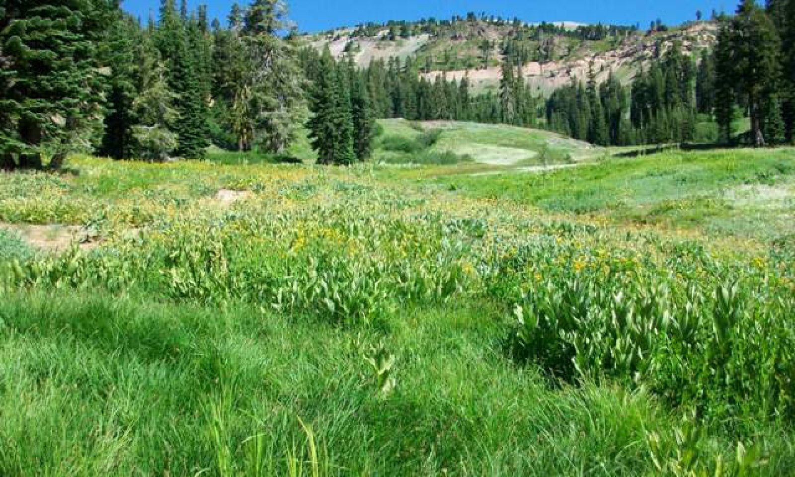
Figure 5. Loamy Seeps View

Figure 6. PCC1- Warm/Cool Spring/Seep

Figure 7. PCC2- Thermal spring/Seep

Figure 8. PCC3 Bulrush

Figure 9. PCC4- Thinleaf Alder

Figure 10. PCC5- Sedge

Figure 11. PCC6- Forb/ Grass

Figure 12. PCC7- Arrowleaf Balsamroot
There is a wide variety in micro-habitats within this ecological site and the plant communities associated it. The sloping valley generally has an active hot or cool spring at the upper ends of the meadow. These springs provide water for the meadow plant communities down the drainage.
Six dominant plant communities have been identified, but there are several other plant communities present.
PCC1: Warm/Cool Spring/Seep Community
This plant community is found at the source of a spring or seep. The composition of plant species in this community is highly variable. Soil-vegetation data was not collected at the source of these springs, so this plant community is based on field notes and photos. Several variables affect the vegetation at the spring, including water temperature, water chemistry, valley slope, soil stability, and flow rate. The photo above for PCC11 is from a stable, cool temperature seep with low flow. It is surrounded by sedges (Carex spp.), mosses, alpine shooting star (Dodecatheon alpinum), American bistort (Polygonum bistortoides), spikerush (Eleocharis spp.), and Howell's marsh marigold (Caltha leptosepala ssp. howellii). Annual production was not collected for this community type.
PCC2: Thermal Spring/Seep Community
This community is found at the source of active thermal springs. Most of these hot springs have neutral pH and low chloride concentrations. The hot springs are associated with the nearby steam vents, formed from vapor-dominated hydrothermal systems. Precipitation infiltrates over time through the rock, then vaporizes and rises to the surface (Thompson, 1985).
Hot springs have variable characteristics. For example, the one in the photo above and described here emerged onto a flat terrace of calcified material. Shortly after emerging, a mat of algal growth forms in the water and along the margins of the small stream. The spring is bordered primarily by seep monkeyflower (Mimulus guttatus). A complex microbial community lives in the geothermal waters but a detailed investigation and description of these microbial communities is beyond the resources for this ecological site at this time. Hot springs ecology is a relatively new science, but studies conducted in Lassen Volcanic National Park indicate that several microbial communities are associated with specific hot spring characteristics. Microbes reside in thermal waters within specific zones of tolerance for temperature and acidity. A study in Cold Boiling Lake indicates that sulfur-metabolizing archaeans are present in the hottest zones (above 60 degrees C), with iron-oxidizing bacteria in cooler zones and photosynthetic algae and cyanobacteria in more moderate zones. Cold Boiling Lake is acidic however, so it’s possible the microbial communities may differ for this site. Cyanobacteria and algae species form thin, dense green microbial mats. These mats are an ecosystem unto themselves with a diversity of organisms, each performing a specific task within the system. The cyanobacteria are on the surface of the mats and produce oxygen through photosynthesis. The oxygen filters into the lower layer where aerobic bacteria and archaea utilize it. The respiration between these organisms can deplete oxygen, creating an anoxic zone where purple sulfur bacteria reside. The purple sulfur bacteria use sulfide produced from sulfide-reducing bacteria (Wilson, et al., 2008 and Engleman).
PCC3: Bulrush Community
This community is found in wet saturated areas near spring sources. It is composed of panicled bulrush (Scirpus microcarpus), Congdon's bulrush (Scirpus congdonii), field horsetail (Equisetum arvense), Ranunculus flammula (greater creeping spearwort), bugle hedgenettle (Stachys ajugoides), willowherb (Epilobium sp.), and Douglas' sagewort (Artemisia douglasiana). This is not a complete species list. Annual production ranges from 3,000 to 3,500 lbs/ acre.
PCC4: Thinleaf Alder Community
The thinleaf alder (Alnus incana ssp. tenuifolia) community is found along active stream channels. Although thinleaf alder dominates, a variety of other species are present, including fowl mannagrass (Glyceria striata), field horsetail (Equisetum arvense), bugle hedgenettle (Stachys ajugoides), willowherb (Epilobium sp.), Douglas' sagewort (Artemisia douglasiana), California false hellebore (Veratrum californicum), and arrowleaf ragwort (Senecio triangularis). The cover of thinleaf alder is very dense, and the diversity and production of the understory is low beneath the canopy. In the canopy openings associated species exhibit higher cover and production. Production of mountain alder ranges from 2,800 to 3,500 lbs/acre. Production of the associated species in the canopy openings (adjusted for production across the landscape) ranges from 300 to 500 lbs/acre.
PCC5: Sedge Community
The sedge plant community is found in stable, flatter areas. It is generally separated from the spring source by a seep community or the bulrush community. It is dominated by mixed sedges (Carex spp.), including littleleaf sedge (Carex luzulifolia), smallwing sedge (Carex microptera), Nebraska sedge (Carex nebrascensis), and analogue sedge (Carex simulata). Other common species are tundra aster (Oreostemma alpigenum), willowherb (Epilobium sp.), tinker's penny (Hypericum anagalloides), Scouler's St. Johnswort (Hypericum scouleri Hook. ssp. scouleri), and mountain rush (Juncus arcticus ssp. littoralis). Species from the grass and forb community are present in small amounts. Annual production ranges from 2,800 to 3,300 lbs/ acre.
PCC6: Forb and Grass Community
This community is dominated by California false hellebore (Veratrum californicum) and arrowleaf ragwort (Senecio triangularis). Other species that may be present include common yarrow (Achillea millefolium), western needlegrass (Achnatherum occidentale), pussytoes (Antennaria sp.), California brome (Bromus carinatus), squirreltail (Elymus elymoides), blue wildrye (Elymus glaucus), common cowparsnip (Heracleum maximum), meadow barley (Hordeum brachyantherum), bigleaf lupine, (Lupinus polyphyllus), and yampah (Perideridia sp.). Annual production ranges from 3,200 to 3,600 lbs/acre.
PCC7: Arrowleaf Balsamroot Community
The arrowleaf balsamroot (Balsamorhiza sagittata) community is found adjacent to the wet meadow and on dry hummocks within the meadow. It is heavily dominated by arrowleaf balsamroot, with a low cover of longspur lupine (Lupinus arbustus), mountain monardella (Monardella odoratissima), Indian paintbrush (Castilleja sp.), California brome (Bromus carinatus), squirreltail (Elymus elymoides), and yampah (Perideridia sp.). Western white pine (Pinus monticola), California red fir (Abies magnifica), and mountain hemlock have low cover. Annual production ranges from 500 to 900 lbs/acre.
If this site becomes permanently stable there is some indication that thinleaf alder thickets may develop. This would be another state, but without data support this state was not included at this time.Community 1.2
Recently Active- Hydrothermally altered seep complex
Figure 13. Headcut

Figure 14. Barren
This Community Phase is a natural phase within State 1. It has the same plant community components as Community Phase 1.1, but the relative distribution of each component has shifted due to changes in hydrology. Additional research into the activity rate of the hot springs and soil movement would be beneficial to determine the impact of these activities on this ecological site. Such research may indicate additional community phases. The scale of impact could potentially be larger than indicated here.
Spring flow can easily be diverted by buildup of microbial and vegetative root mats. The barren community in the photo above was created when the small stream was diverted by a dense vegetative growth of seep monkeyflower. The subsequent decline in water availability caused the hydrophytic vegetation to decline and the more upland species have not yet established. With time these hummocks will re-vegetate. The plant community that will return depends upon water table depth.
The hummocky nature of these sloping meadows may be a result of slow soil movement. As the fine textured soils saturate and become viscid, the stream headcuts through the lower toeslopes of the hummocks as it tries to regain a natural gradient. As the stream down cuts, it creates drier terraces above the channel. The forb/grass community may replace the wetter community components.
PCC8, Barren Community
This community is basically barren, but there are scattered plants present including mountain rush (Juncus arcticus ssp. littoralis), seep monkeyflower (Mimulus guttatus), bugle hedgenettle (Stachys ajugoides), Douglas' thistle (Cirsium douglasii), Douglas' sagewort (Artemisia douglasiana), mat muhly (Muhlenbergia richardsonis), and sanddune wallflower (Erysimum capitatum). Annual production has not been collected on this plant community but is estimated to be between 10 to 70 lbs/acre.Pathway 1.1a
Community 1.1 to 1.2
Hydrothermally Altered Seep Complex
Recently Active- Hydrothermally altered seep complexThis pathway is created by changes in spring flow, channel course, or stream gradient, which alters the surrounding hydrology and plant communities.
Pathway 1.2a
Community 1.2 to 1.1
Recently Active- Hydrothermally altered seep complex
Hydrothermally Altered Seep ComplexThis pathway is created during periods of stability.
Additional community tables
Table 5. Community 1.1 plant community composition
Group Common name Symbol Scientific name Annual production () Foliar cover (%) Table 6. Community 1.2 plant community composition
Group Common name Symbol Scientific name Annual production () Foliar cover (%) Interpretations
Animal community
This site provides basic and valuable resources for wildlife such as water, forage, and cover. The leaves, stems, and seeds of Nebraska sedge, tufted hairgrass, and other grasses and sedges provide forage for wildlife and livestock. The sedges and bunchgrasses provide nesting habitat for waterfowl and cover for small mammals.
Hydrological functions
The hydrologic function of this ecological site is to provide a catchment for water, sediments, and nutrients. These sites allow sediments from spring snow melt to settle out and trap nutrients in surface and subsurface flows. This site stores water and releases it slowly down the drainage throughout the year.
Recreational uses
This site provides beautiful open scenery for wildlife viewing and photography. Caution is recommended travelling in this area because of hydrothermal seeps.
Supporting information
Inventory data references
The following NRCS vegetation plots have been used to describe this ecological site: 789258 Type location 789258B (PCC3) 789281 (PCC5 and PCC6) 789282(PCC3, PCC5 and PCC6) 789344
Type locality
Location 1: Tehama County, CA Township/Range/Section T30 N R4 E S22 UTM zone N UTM northing 4477823 UTM easting 624614 General legal description The type location is about 1/2 a mile SSW of Sulphur Works parking lot in Lassen Volcanic National Park. Other references
Bestelmeyer, Brandon T.; Brown, Joel R.; Havstad, Kris M.; Alexander, Robert; Chavez, George; and Herrick Jeffrey E.; 2003. Development and Use of State-and-Transition Models for Rangelands. Journal of Range Management, Vol. 56, No. 2 (Mar., 2003), pp. 114-126. Allen Press and Society for Range Management. Stable URL: http://www.jstor.org/stable/4003894
Bestelmeyer, Brandon T.; Tugel, Arlene J.; Peacock, George L. Jr.; Robinett, Daniel G.; Shaver, Pat L.; Brown, Joel R.; Herrick, Jeffrey E.; Sanchez, Homer; and Havstad, Kris M.; 2009. State-and-Transition Models for Heterogeneous Landscapes: A Strategy for Development and Application. Rangeland Ecology and Management 62:1–15; January 2009.
Briske, D. D., Fuhlendorf, S. D; and Smeins, F. E., 2006. A Unified Framework for Assessment and Application of Ecological Thresholds. Rangeland Ecology and Management 59:225–236.
Briske, D. D; Bestelmeyer B. T; Stringham, T. K., and Shaver, P. L., 2008. Recommendations for Development of Resilience-Based State-And-Transition Models. Rangeland Ecology and Management 61:359–367.Bestelmeyer el al. 2003,
Briske, D. D.; Fuhlendorf, S. D.; and Smeins, F. E.; 2009. State-and-Transition Models, Thresholds, and Rangeland Health: A Synthesis of Ecological Concepts and Perspectives. Rangeland Ecology & Management, Vol. 58, No. 1 (Jan., 2005), pp. 1-10. Allen Press and Society for Range Management. Stable URL: http://www.jstor.org/stable/3899791
Clynne, Michael A.; Janik, Cathy J.; and Muffler, L.J.P. Fact Sheet 101-02 “Hot Water” in Lassen Volcanic National Park— Fumaroles, Steaming Ground, and Boiling Mudpots. U.S. Geological Survey.
Engleman, Kurt. Hot Springs Ecology. Humboldt State University, online at http://users.humboldt.edu/plsiering/LIBARATE/Kurt%20Engleman/k-ecology.htm
Stringham, T.K., W.C. Krueger, and P.L. Shaver. 2003. State and Transition Modeling: An Ecological Process Approach. J. Range Manage 56: 106-113.
Thompson, J. Michael, 1985. Chemistry of thermal and nonthermal springs in the vicinity of Lassen Volcanic National Park. Journal of Volcanology and Geothermal Research. Volume 25, Issues 1-2, June 1985, Pages 81-104. Copyright © 1985 Published by Elsevier B.V.
USDA, NRCS. 2007. The PLANTS Database. National Plant Data Center, Baton Rouge, LA 70874-4490 USA. Available online at: http://plants.usda.gov
USDA, NRCS. 2003. National Range and Pasture Handbook. Available online at: http://www.glti.nrcs.usda.gov/technical/publications/nrph.html
Weixelman, Dave; Weis, Sue; Linton, Fletcher; and Swartz, Heather; 2007. DRAFT: Condition Checklist for Fens in the Montane and Subalpine Zones of the Sierra Nevada and Southern Cascade Ranges, CA.
Wilson, Mark S.; Siering, Patricia L.; White, Christopher L.; Hauser, Michelle E.; and Bartles, Andrea N. (2008). Microbial diversity and dynamics in an acidic hotspring at Lassen Volcanic National Park. Environmental Microbiology, 56 (2), 292-305 (http://www.springerlink.com/content/371xh7144562w637)Contributors
Marchel M. Munnecke
Rangeland health reference sheet
Interpreting Indicators of Rangeland Health is a qualitative assessment protocol used to determine ecosystem condition based on benchmark characteristics described in the Reference Sheet. A suite of 17 (or more) indicators are typically considered in an assessment. The ecological site(s) representative of an assessment location must be known prior to applying the protocol and must be verified based on soils and climate. Current plant community cannot be used to identify the ecological site.
Author(s)/participant(s) Contact for lead author Date Approved by Approval date Composition (Indicators 10 and 12) based on Annual Production Indicators
-
Number and extent of rills:
-
Presence of water flow patterns:
-
Number and height of erosional pedestals or terracettes:
-
Bare ground from Ecological Site Description or other studies (rock, litter, lichen, moss, plant canopy are not bare ground):
-
Number of gullies and erosion associated with gullies:
-
Extent of wind scoured, blowouts and/or depositional areas:
-
Amount of litter movement (describe size and distance expected to travel):
-
Soil surface (top few mm) resistance to erosion (stability values are averages - most sites will show a range of values):
-
Soil surface structure and SOM content (include type of structure and A-horizon color and thickness):
-
Effect of community phase composition (relative proportion of different functional groups) and spatial distribution on infiltration and runoff:
-
Presence and thickness of compaction layer (usually none; describe soil profile features which may be mistaken for compaction on this site):
-
Functional/Structural Groups (list in order of descending dominance by above-ground annual-production or live foliar cover using symbols: >>, >, = to indicate much greater than, greater than, and equal to):
Dominant:
Sub-dominant:
Other:
Additional:
-
Amount of plant mortality and decadence (include which functional groups are expected to show mortality or decadence):
-
Average percent litter cover (%) and depth ( in):
-
Expected annual annual-production (this is TOTAL above-ground annual-production, not just forage annual-production):
-
Potential invasive (including noxious) species (native and non-native). List species which BOTH characterize degraded states and have the potential to become a dominant or co-dominant species on the ecological site if their future establishment and growth is not actively controlled by management interventions. Species that become dominant for only one to several years (e.g., short-term response to drought or wildfire) are not invasive plants. Note that unlike other indicators, we are describing what is NOT expected in the reference state for the ecological site:
-
Perennial plant reproductive capability:
Print Options
Sections
Font
AAAAOther
PrintThe Ecosystem Dynamics Interpretive Tool is an information system framework developed by the USDA-ARS Jornada Experimental Range, USDA Natural Resources Conservation Service, and New Mexico State University.
Accessibility statement


