
Natural Resources
Conservation Service
-
Search


Major Land Resource Area or ecological site by name and/or ID.
PreviousSectionsNextGeneral information
Provisional. A provisional ecological site description has undergone quality control and quality assurance review. It contains a working state and transition model and enough information to identify the ecological site.
Click to explore map
Figure 1. Mapped extent
Areas shown in blue indicate the maximum mapped extent of this ecological site. Other ecological sites likely occur within the highlighted areas. It is also possible for this ecological site to occur outside of highlighted areas if detailed soil survey has not been completed or recently updated.
MLRA notes
Major Land Resource Area (MLRA): 022A–Sierra Nevada and Tehachapi Mountains
Major Land Resource Area 22A, Sierra Nevada Mountains, is located predominantly in California and a small section of western Nevada. The area lies completely within the Sierra Nevada Section of the Cascade-Sierra Mountains Province. The Sierra Nevada range has a gentle western slope, and a very abrupt eastern slope. The Sierra Nevada consists of hilly to steep mountains and occasional flatter mountain valleys. Elevation ranges between 1,500 and 9,000 ft throughout most of the range, but peaks often exceed 12,000 ft. The highest point in the continental US occurs in this MLRA (Mount Whitney, 14,494 ft). Most of the Sierra Nevada is dominated by granitic rock of the Mesozoic age, known as the Sierra Nevada Batholith. The northern half is flanked on the west by a metamorphic belt, which consists of highly metamorphosed sedimentary and volcanic rocks. Additionally, glacial activity of the Pleistocene has played a major role in shaping Sierra Nevada features, including cirques, arêtes, and glacial deposits and moraines. Average annual precipitation ranges from 20 to 80 inches in most of the area, with increases along elevational and south-north gradients. Soil temperature regime ranges from mesic, frigid, and cryic. Due to the extreme elevational range found within this MLRA, Land Resource Units (LRUs) were designated to group the MLRA into similar land units.
LRU "E" Northern Sierran Upper Montane: This LRU occurs at the mid elevations of the Sierra Nevada, from the Sonora Pass area to the higher mountains in the vicinity of Quincy. Elevations are typically between 5,500 feet to 8,500 feet, with the lower elevations typically on southern aspects, and the higher elevations on northern aspects. The frost-free season is 60 to 125 days, MAAT ranges from 40 to 50 F, and MAP ranges from 35 to 85 inches. The soil temperature regime is mostly frigid, with some cryic soil temperatures at the upper elevations and northern aspects. Soil moisture regimes are mostly xeric, but may be udic where snow persists through spring.Ecological site concept
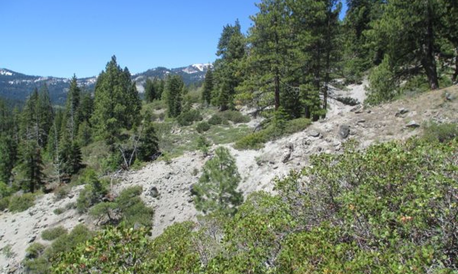
This ecological site is associated with shallow loamy soils that have developed over strongly cemented andesitic bedrock. Elevations range from 6,200 to 7,700 feet and slopes are typically between 30 and 70 percent. This site is typically found on undulating south facing slopes in patchy areas of shallow soil, with exposed bedrock within a forest matrix. Shallow, erosion prone soils and warm aspects support only sparse tree cover, and the dominant vegetation is open and diverse montane chaparral. Huckleberry oak (Quercus vaccinifolia) is the most frequent shrub, and greenleaf manzanita (Arctostaphylos patula) is also common. The loamy volcanic soils and undulating, dissected landscape support a higher diversity of shrubs and forbs than is found in montane chaparral communities associated with granitic substrates and more uniform slopes. Forbs are especially diverse on this site, with up to 27 different species occurring at a single location. Forbs tend to be distributed in more open patches of soil and around exposed bedrock.
Associated sites
F022AE008CA Frigid Loamy Moraine Slopes
Occurs on adjacent moraine slopes with very deep soils volcanic soils. The vegetation is red fir (Abies magnifica) - white fir (Abies concolor) forest.
F022AE013CA Frigid, Loamy, Volcanic Mountain Slopes
Occurs on adjacent mountain slopes with loamy, moderately deep to deep andesitic soils. The vegetation is a white fir (Abies concolor) mixed conifer forest. White fir, jeffrey pine (Pinus jeffreyi), sugar pine (Pinus lambertiana) and incense cedar (Calocedrus decurrens) are all important species.
R022AX104CA Sphagnum Fen
Occurs on sphagnum fens.
R022AX107CA Frigid C Channel System
Occurs along C type channels with gravelly to cobbly channel substrates. The vegetation is dominated by Lemmons willow (Salix lemmonii) with mixed forbs.
Similar sites
R022AE213CA Steep Rubbly Slope
This site is associated with very steep, rubbly slopes. It has a denser shrub cover and lower diversity of herbaceous species.
Table 1. Dominant plant species
Tree Not specified
Shrub (1) Quercus vacciniifolia
(2) Arctostaphylos patulaHerbaceous (1) Erigeron peregrinus
(2) Penstemon deustusPhysiographic features
This site is found on glacially scoured side slopes at elevations of 6,200 to 7,710 feet. This site is found on all aspects but more typically on south facing slopes. Slopes can range from 9 to 70 percent, but slopes of 30 to 50 percent are typical. Runoff class is very high.
Table 2. Representative physiographic features
Landforms (1) U-shaped valley
Flooding frequency None Ponding frequency None Elevation 6200 – 7710 ft Slope 9 – 70 % Aspect SE, S, SW Climatic features
The climate of this ecological site is characterized by cool temperatures, wet winters with most precipitation falling as snow in winters, and relatively dry summers. The average annual precipitation ranges from 23 to 63 inches. The average annual air temperature ranges from 40 to 46 degrees Fahrenheit. The frost-free (>32F) season is 40 to 90 days. The freeze-free (>28F) season is 70 to 110 days.
Table 3 Representative climatic features
Frost-free period (average) 90 days Freeze-free period (average) 70 days Precipitation total (average) 40 in BarLineFigure 2. Monthly precipitation range
BarLineFigure 3. Monthly average minimum and maximum temperature
Figure 4. Annual precipitation pattern
Figure 5 Annual average temperature pattern
">Influencing water features
This ecological site is not influenced by wetland or riparian water features.
Soil features
The soils associated with this ecological site are shallow, and formed in colluvium derived from andesitic lahar or welded tuff. They are excessively drained with rapid permeability. The soil moisture regime is typic xeric and the soil temperature regime is frigid. Surface rock fragments smaller than 3 mm in diameter average 25 percent, and larger fragments average 6 percent. The surface texture is stony very fine sandy loam, and subsurface textures are very cobbly sandy loam and extremely gravelly fine sandy loam. Subsurface rock fragments smaller than 3 mm in diameter range from 15 to 50 percent by volume, and larger fragments range from 10 to 25 percent (for a depth of 0 to 12 inches). The soils correlated to this site include Ellispeak (loamy-skeletal, isotic, frigid Lithic Haploxerolls).
This ecological site has been correlated with the following mapunits and soil components in the Tahoe Basin soil survey area (CA693):
Area_sym ; Musym ; MUname ; Compname ; Local_phase ; Comp_pct
CA693 ; 7121 ; Ellispeak-Rock outcrop complex, 9 to 30 percent slopes ; Ellispeak ; ; 45
CA693 ; 7122 ; Ellispeak-Rock outcrop complex, 30 to 50 percent slopes ; Ellispeak ; ; 45
CA693 ; 7123 ; Ellispeak-Rock outcrop complex, 50 to 70 percent slopes ; Ellispeak ; ; 45
CA693 ; 7131 ; Ellispeak-Waca complex, 9 to 30 percent slopes ; Ellispeak ; ; 45
CA693 ; 7132 ; Ellispeak-Waca complex, 30 to 50 percent slopes ; Ellispeak ; ; 45
CA693 ; 7133 ; Ellispeak-Waca complex, 50 to 70 percent slopes ; Ellispeak ; ; 45
CA693 ; 7151 ; Jorge very cobbly fine sandy loam, 5 to 15 percent slopes, rubbly ; Ellispeak ; ; 2
CA693 ; 7152 ; Jorge very cobbly fine sandy loam, 15 to 30 percent slopes, rubbly ; Ellispeak ; ; 2
CA693 ; 7153 ; Jorge very cobbly fine sandy loam, 30 to 50 percent slopes, rubbly ; Ellispeak ; ; 2
CA693 ; 7154 ; Jorge very cobbly loam, 2 to 15 percent slopes, extremely stony ; Ellispeak ; ; 3
CA693 ; 7155 ; Jorge very cobbly loam, 15 to 50 percent slopes, extremely stony ; Ellispeak ; ; 3
CA693 ; 7156 ; Jorge-Tahoma complex, 15 to 30 percent slopes ; Ellispeak ; ; 1
CA693 ; 7157 ; Jorge-Tahoma complex, 30 to 50 percent slopes ; Ellispeak ; ; 1
CA693 ; 7221 ; Tahoma very cobbly sandy loam, 2 to 15 percent slopes, very stony ; Ellispeak ; ; 1
CA693 ; 7222 ; Tahoma-Jorge complex, 2 to 15 percent slopes ; Ellispeak ; ; 1
CA693 ; 7231 ; Waca very gravelly medial coarse sandy loam, 9 to 30 percent slopes ; Ellispeak ; ; 5
CA693 ; 7232 ; Waca very gravelly medial coarse sandy loam, 30 to 50 percent slopes ; Ellispeak ; ; 5
CA693 ; 7233 ; Waca very gravelly medial coarse sandy loam, 50 to 70 percent slopes ; Ellispeak ; ; 5
CA693 ; 9121 ; Watsonlake gravelly sandy loam, 5 to 15 percent slopes, rubbly ; Ellispeak ; ; 1
CA693 ; 9122 ; Watsonlake gravelly sandy loam, 15 to 30 percent slopes, rubbly ; Ellispeak ; ; 1
CA693 ; 9123 ; Watsonlake gravelly sandy loam, 30 to 50 percent slopes, rubbly ; Ellispeak ; ; 1
Table 4. Representative soil features
Parent material (1) Colluvium – andesite
Surface texture (1) Stony very fine sandy loam
Family particle size (1) Loamy
Drainage class Excessively drained Permeability class Rapid Soil depth 10 – 20 in Surface fragment cover <=3" 25 % Surface fragment cover >3" 6 % Available water capacity
(0-40in)0.8 – 0.9 in Subsurface fragment volume <=3"
(Depth not specified)15 – 50 % Subsurface fragment volume >3"
(Depth not specified)10 – 25 % Ecological dynamics
Abiotic factors
This ecological site is associated with shallow loamy soils that have developed over strongly cemented andesitic bedrock. Exposed volcanic outcrops are commonly present. This site is typically found on undulating south facing slopes in patchy areas of shallow soil within a forest matrix. Shallow, erosion prone soils and warm aspects support only sparse tree cover, and the dominant vegetation is open and diverse montane chaparral. Huckleberry oak is the most frequent shrub, with greenleaf manzanita also common. The loamy volcanic soils and undulating, dissected landscape support a higher diversity of shrubs and forbs than is found in montane chaparral communities associated with granitic substrates and more uniform slopes. Forbs are especially diverse on this site, with up to 27 different species occurring at a single location. Forbs tend to be distributed in more open patches of soil and around exposed bedrock. Scabland penstemon (Penstemon deustus), which is associated with open rocky volcanic habitats (Jepson 1993), is one of the most abundant forbs on this site.
Abiotic factors
This ecological site is associated with shallow loamy soils that have developed over strongly cemented andesitic bedrock. Exposed volcanic outcrops are commonly present. This site is typically found on undulating south facing slopes in patchy areas of shallow soil within a forest matrix. Shallow, erosion prone soils and warm aspects support only sparse tree cover, and the dominant vegetation is open and diverse montane chaparral. Huckleberry oak is the most frequent shrub, with greenleaf manzanita also common. The loamy volcanic soils and undulating, dissected landscape support a higher diversity of shrubs and forbs than is found in montane chaparral communities associated with granitic substrates and more uniform slopes. Forbs are especially diverse on this site, with up to 27 different species occurring at a single location. Forbs tend to be distributed in more open patches of soil and around exposed bedrock. Scabland penstemon (Penstemon deustus), which is associated with open rocky volcanic habitats (Jepson 1993), is one of the most abundant forbs on this site.
Disturbance factors
Fire is the primary disturbance impacting ecological dynamics of this site. The shrub community associated with this site is fire dependent, and forb richness benefits from relatively frequent burning (e.g. Wayman and North, 2007, Webster 2010). The fire return interval for montane chaparral ranged from 6 to 77 years prior to European settlement (Nagal and Taylor 2005). A high cover of bare ground and patchily distributed shrubs in this site mean that fire would not spread as rapidly or have the same severity as in chaparral dominated sites with more continuous shrub cover; nevertheless, fire is important in maintaining the reference community of this site.
For the past century, fires have been almost non-existent in this site due to fire suppression, which has allowed trees to increase (Nagal and Taylor 2005). In chaparral communities on the west shore of Lake Tahoe, where this site occurs, tree encroachment is estimated to have occurred in over 60% of chaparral stands (Nagal and Taylor 2005). The shallow, erosive soils of this site are quite resistant to forest encroachment, but undoubtedly tree cover has increased beyond historic ranges. With a lack of fire, shrubs increase in cove, causing forb cover and diversity to decline, and as trees increase in height and cover, shrub growth is suppressed, slowly resulting in forest encroachment into this site.
Livestock grazing may have impacted this ecological site. Exploitative grazing practices in the Sierra Nevada from the 1850s to approximately 1930 impacted many forest, shrub, meadow and riparian communities (Elliot-Fisk et al. 1996, Taylor 2004). Heavy and pervasive sheep grazing in the Lake Tahoe Basin removed all grasses and palatable shrubs in some areas by 1900 (Sudworth, 1900, quoted in Elliot-Fisk et al. 1996). Documentation of grazing impacts in this site is not available, so impacts of grazing are speculative only. Grass cover may have been more abundant prior to livestock grazing, and grazing may have increased erosion of the shallow steep soils of this site.
Invasive species are largely absent in this site; and the shallow soils and warm aspects confer some resilience against invasion. However, cheatgrass (Bromus tectorum) may be present in the site at low levels, and has only invaded in the last 10 years (NRCS plot data). Cheatgrass has the potential to become abundant after fire, outcompeting native species and reducing site diversity, and shortening the fire return interval by providing continuous flashy fuel cover (e.g. Holmgren, 1956; McIver et al. 2010).
State and transition model
Custom diagramStandard diagram
Figure 6. R022AE217CA
More interactive model formats are also available. View Interactive Models
More interactive model formats are also available. View Interactive Models
Click on state and transition labels to scroll to the respective textEcosystem states
State 1 submodel, plant communities
State 1
Reference StateThis state represents the reference conditions for this ecological site. The reference state consists of the reference community phase (numbered 1.1), which is the most successionally advanced community phase under a typical disturbance regime, as well as other community phases that result from natural and human disturbances.
All tabular data listed for a specific community phase within this ecological site description represent a summary of one or more field data collection plots taken in communities within the community phase. Although such data are valuable in understanding the phase (kinds and amounts of ground and surface materials, canopy characteristics, community phase overstory and understory species, production and composition, and growth), it typically does not represent the absolute range of characteristics nor an exhaustive listing of species for all the dynamic communities within each specific community phase.
Community 1.1
Reference Plant Community
Figure 7. Community Phase 1.1

Figure 8. Community Phase 1.1
Patchy chaparral cover, a diverse forb community, and a high cover of bare ground characterize the reference plant community. Average shrub cover is 30 percent, which is dominated by huckleberry oak and greenleaf manzanita. The shrub community is diverse, with up to twelve different species typical. Prosrate ceanothus (Ceanothus prostratus), Utah serviceberry (Amelanchier utahensis), are important secondary shrubs, and pinemat manzanita (Arctostaphylos nevadensis), bitter cherry (Prunus emarginata), roundleaf snowberry (Symphoricapos rotundifolius), creeping snowberry (S. mollis), and Sierra gooseberry (Ribes roezlii) are among the frequently encountered secondary shrubs, but other species may also be present. Trees are scattered and patchy, and favor concave microsites where there is additional run-on and soil accumulation, or colonize shrub patches where there is shade and soils are stable. Prostrate ceonothus is a nitrogen fixing species that can act as a nurse plant for trees and other shrubs (Brown et al. 1971). This site is surrounded by Jeffrey pine (Pinus jeffreyi) - white fir (Abies magnifica) forest (F022AE007CA), and these are the most common tree species occurring on the site. Western white pine (Pinus monticola) may also be present at higher elevations.
A diverse forb community supported by greater soil moisture holding capacity and fertility in fine-textured volcanic soils is one of the factors distinguishing this site from other chaparral sites. Up to 27 different forb species may occur at a single location, and the 12 species listed below are most frequently encountered. Forbs contribute an average of 8 percent cover on this site, and 85 pounds annual production. Generally cover and production of individual species tends to be sparse. Scabland penstemon (Penstemon deustus), subalpine fleabane (Erigeron peregrinus), wavyleaf indian paintbrush (Castilleja applegatei) and Torrey’s blue-eyed Mary (Collinsia torreyi) are among the more abundant species.
Grasses are not abundant in this site, contributing an average 2 percent cover and 18 pounds annual production. Squirreltail (Elymus elymoides), Sandberg bluegrass (Poa secunda) and needlegrass (Achnatherum spp.) are frequently present, and other more rarely encountered species may be present. Grass cover could have been higher prior to widespread heavy livestock grazing in the Lake Tahoe Basin, but historical information is not available.
Figure 9. Annual production by plant type (representative values) or group (midpoint values)
Table 5. Annual production by plant type
Plant type Low
(lb/acre)Representative value
(lb/acre)High
(lb/acre)Shrub/Vine 700 1600 2500 Forb 40 85 130 Tree 25 60 90 Grass/Grasslike 4 18 30 Total 769 1763 2750 Table 6. Ground cover
Tree foliar cover 0-0% Shrub/vine/liana foliar cover 10-30% Grass/grasslike foliar cover 0% Forb foliar cover 0-10% Non-vascular plants 0% Biological crusts 0% Litter 20-50% Surface fragments >0.25" and <=3" 10-30% Surface fragments >3" 10-20% Bedrock 0-0% Water 0% Bare ground 0-50% Table 7. Canopy structure (% cover)
Height Above Ground (ft) Tree Shrub/Vine Grass/
GrasslikeForb <0.5 0-1% 1-16% 0-2% 1-5% >0.5 <= 1 0-2% 1-16% 0-2% 1-17% >1 <= 2 0-2% 1-5% 0-2% 0-3% >2 <= 4.5 1-5% 6-50% – – >4.5 <= 13 3-8% – – – >13 <= 40 3-8% – – – >40 <= 80 – – – – >80 <= 120 – – – – >120 – – – – Community 1.2
Fire Recovery (Provisional)The reference community is adapted to fire; with most shrubs associated with this site able to resprout after the aerial portion of the shrub has been killed or to regenerate from heat-activated seed that is long-lived in the soil seed bank. Huckleberry oak is a fire-adapted species that is highly flammable and vigorously resprouts from the root crown after fire (Howard 1992, Nagal and Taylor 2005, Odion et al. 2009). Greenleaf manzanita vigorously resprouts from underground lignotubers, and regenerates from heat scarified seeds that may survive in the soil for more than 400 years (Nagal and Taylor 2005, Hauser 2007). Prostrate ceanothus is a pioneering shrub in this site. It recruits from long-lived seed that is stimulated by fire, and forms large mats that stabilize soils and fix nitrogen, enhancing soils for colonization by other species (Skau et al. 1970, Brown et al. 1971). With rapid regeneration from root sprouts, and recruitment from on site seed stores, this shrubland can resemble preburn coverage in 7 to 9 years (Risser and Fry, 1988). Bitter cherry, Sierra gooseberry, round-leaf and creeping snowberry, and Utah service berry can all resprout after fire. Pinemat manzanita is killed by fire, but likely has fire-adapted seeds that will germinate in the first year post-fire (Howard 1993).
Many forbs, such as scabland penstemon, may escape severe burning due to their location around exposed bedrock and in bare patches of soil, and forbs will rapidly colonize bare soil patches newly free of shrub cover, leading to forb dominance in the first several years after fire (e.g. Wright 1985, Wayman and North 2007). Annuals such as spreading groundsmoke (Gayophytum diffusum) and Torrey’s blue-eyed Mary are likely to become very abundant in the first season after fire (Wright 1985, Schoennagel et al. 2004, Wayman and North 2007). The perennial silverleaf phacelia (Phacelia hastata) is considered a ‘fire-follower’ and is also likely to be abundant early after fire (Major and Rejmanek 1992, Wayman and North 2007). Perennials that are only top-killed by fire and that spread by rootstocks such as lambstongue ragwort (Senecio intigerrimus), spreading fleabane, woolly mules-ears (Wyethia mollis), and dusky onion (Allium campanulatum) will increase in abundance by the second or third season after fire. Woolly mules-ears can greatly increase after fire, sometimes becoming dominant (Parker and Yoder-Williams 1989, Riegel et al. 2002).
Grass cover is also likely to increase in the first years post-fire. Squirreltail and Sandberg bluegrass are highly tolerant of fire (Wright 1985). The effects of fire on needlegrasses depend on the severity and season of burning and needlgrass are likely to survive fire in this area because of the low amount of fuel around the plant base. They will also reproduce from stored and wind blown seed.
The effects of fire on trees in this site will depend on fire severity. Most adult trees will remain standing due to the probability of low severity fire, but trees located within shrub patches and saplings and small trees are more likely to be killed. Adult Jeffrey pine and even saplings are likely to survive the low intensity fire that would occur in this site, although seedlings may be killed (Gucker 2007). Small white fir and western white pine are likely to be killed, but adults experiencing moderate severity fire may survive (Griffith 1992, Zouhar 2001). Due to slow growth of trees on this site, tree recovery will be slow if mortality is high.
This community phase is susceptible to invasion by cheatgrass.
Community 1.3
Fire Suppression (Provisional)A national policy of fire suppression over the last century has meant that many locations where this ecological site occurs have not burned for more than 120 years (Nagal and Taylor 2005). Prior to fire suppression, long periods of time between fires were possible, with a maximum range of 20 to 77 years (Nagal and Taylor 2005). Tree cover would have increased during long fire intervals, but not as systemically over as wide an area as the current time. Shrub and tree regeneration is most pronounced in the decade immediately following fire, but may continue for at least five decades and probably longer, resulting in mix-aged shrub stands (Nagal and Taylor 2005). Data is not available for this community phase, but it is assumed that cover of Jeffrey pine, white fire, and western white pine, which are characteristic of surrounding forests and already present at low cover in the reference community, would increase, while forb, huckleberry oak, greenleaf manzanita, prostrate ceanothus and other shrubs would decrease.
Pathway 1.1a
Community 1.1 to 1.2Occurs with fire.
Pathway 1.1b
Community 1.1 to 1.3Occurs with long-term fire suppression.
Pathway 1.2a
Community 1.2 to 1.1Occurs with time without additional fire.
Pathway 1.3a
Community 1.3 to 1.2Occurs with fire.
Additional community tables
Table 8. Community 1.1 plant community composition
Group Common name Symbol Scientific name Annual production () Foliar cover (%) Tree1 Trees 25–90 Jeffrey pine PIJE Pinus jeffreyi 1–60 1–5 western white pine PIMO3 Pinus monticola 1–30 1–5 white fir ABCO Abies concolor 1–30 1–5 Shrub/Vine2 Shrubs 700–2500 huckleberry oak QUVA Quercus vacciniifolia 100–1200 5–20 greenleaf manzanita ARPA6 Arctostaphylos patula 100–900 1–15 Utah serviceberry AMUT Amelanchier utahensis 0–135 0–2 prostrate ceanothus CEPR Ceanothus prostratus 0–125 0–6 bitter cherry PREM Prunus emarginata 0–15 0–10 pinemat manzanita ARNE Arctostaphylos nevadensis 1–15 1–10 Sierra gooseberry RIROR Ribes roezlii var. roezlii 0–5 0–1 creeping snowberry SYMO Symphoricarpos mollis 0–5 0–1 roundleaf snowberry SYRO Symphoricarpos rotundifolius 0–5 0–1 Forb3 Forbs 40–130 subalpine fleabane ERPE3 Erigeron peregrinus 0–30 0–5 scabland penstemon PEDE4 Penstemon deustus 0–20 0–2 Ashland cinquefoil POGLA2 Potentilla glandulosa ssp. ashlandica 0–6 0–1 wavyleaf Indian paintbrush CAAP4 Castilleja applegatei 0–6 0–1 Torrey's blue eyed Mary COTO Collinsia torreyi 0–3 0–1 dusky onion ALCA2 Allium campanulatum 0–1 0–1 spreading groundsmoke GADI2 Gayophytum diffusum 0–1 0–1 mountain monardella MOOD Monardella odoratissima 0–1 0–1 lambstongue ragwort SEIN2 Senecio integerrimus 0–1 0–1 waxy checkerbloom SIGL2 Sidalcea glaucescens 0–1 0–1 woolly mule-ears WYMO Wyethia mollis 0–1 0–1 Grass/Grasslike4 Grasses and Grasslike 4–30 needlegrass ACHNA Achnatherum 0–10 0–2 squirreltail ELEL5 Elymus elymoides 0–10 0–2 Sandberg bluegrass POSE Poa secunda 0–10 0–2 Table 9. Community 1.2 plant community composition
Group Common name Symbol Scientific name Annual production () Foliar cover (%) Table 10. Community 1.3 plant community composition
Group Common name Symbol Scientific name Annual production () Foliar cover (%) Interpretations
Animal community
This shrubland community provides food from leaf tissue, fruits, seeds, and nuts for deer, bears, squirrels, birds, and other animals.
Recreational uses
This area is generally too steep and rocky to be used for recreation, but some trails do exist in this terrain.
Other information
The fruits of greenleaf manzanita can be eaten raw or made into tea (Hauser, 2007). The fruits of bitter cherry are used as a laxative, and the roots and inner bark were boiled to make a medicine to prevent heart trouble. The bark of bitter cherry is used to make baskets (Esser, 1995).
Supporting information
Inventory data references
The following NRCS TEUI and production plots were used to describe this ecological site: Mxf04117 (Type location) Elf04026 Ra03h173
Type locality
Location 1: Placer County, CA Township/Range/Section T15N R16E S27 UTM zone N UTM northing 4333098 UTM easting 742828 General legal description Take HW 89 along the west shore to Barker Pass Road. Plot is upslope on north side of road. Other references
Brown, R. W., R. H. R. Jr., and E. E. Farmer. 1971. Suitability of Ceanothus prostratus Benth. for the revegetation of harsh sites. U.S. Department of Agriculture, Forest Service, Intermountain Forest and Range Experiment Station, Ogden, UT.
Elliot-Fisk, D. L., R. Harris, R. A. Rowntree, T. C. Cahill, R. Kattelmann, P. Rucks, O. K. Davis, R. Lacey, D. A. Sharkey, L. Duan, D. Leisz, S. L. Stephens, C. R. Goldman, S. Lindstrom, D. S. Ziegler, G. E. Gruell, and D. Machida. 1996. Lake Tahoe Case Study. Pages 217-276 Sierra Nevada Ecosystem Project. University of California, Centers for Water and Wildland Resources, Davis, CA.
Griffith, R. S. 1992. Pinus monticola. Fire Effects Information System, [Online]. U.S. Department of Agriculture, Forest Service, Rocky Mountain Research Station, Fire Sciences Laboratory.
Gucker, C. L. 2007. Pinus jeffreyi. Fire Effects Information System [Online]. U.S. Department of Agriculture, Forest Service, Rocky Mountain Research Station, Fire Sciences Laboratory.
Holmgren, R. C. 1956. Competition between annuals and young bitterbrush (Pushia tridentata) in Idaho. Ecology 37:370-378.
Jepson, W. L. 1993. The Jepson manual: higher plants of California. University of California Press, Berkeley, CA.
Major, J. and M. Rejmanek. 1992. Amelanchier alnifolia vegetation in eastern Idaho, USA and its environmental relationships. Vegetatio 98:141-156.
McIver, J. D., M. Brunson, S. Bunting, J. Chambers, N. Devoe, P. Doescher, J. Grace, D. Johnson, S. Knick, R. Miller, M. Pellant, F. Pierson, D. Pyke, K. Rollins, B. Roundy, E. Schupp, R. Tausch, and D. Turner. 2010. The Sagebrush StepeTreatment Evaluation Project (SageSTEP): A test of State-and-Transition Theory. USDA Forest Service, Rocky Mountain Research Station, Fort Collins, CO.
Nagal, T. A. and A. H. Taylor. 2005. Fire and persistence of montane chaparral in mixed conifer forest landscapes in the northern Sierra Nevada, Lake Tahoe Basin, California, USA. Journal of the Torrey Botanical Society 132:442-457.
Schoennagel, T., D. M. Waller, M. G. Turner, and W. H. Romme. 2004. The effect of fire interval on post-fire understorey communities in Yellowstone National Park. Journal of Vegetation Science 15:797-806.
Skau, C. M., R. O. Meeuwig, and T. W. Townsend. 1970. Ecology of eastside Sierra chaparral, a literature review. Max C. Fleischmann College of Agriculture, University of Nevada Reno, Reno, NV.
Taylor, E. H. 2004. Identifying forest reference conditions on early cut-over lands, Lake Tahoe Basin, USA. Ecological Applications 14:1903-1920.
Wayman, R. B. and M. North. 2007. Initial response of a mixed-conifer understory plant community to burning and thinning restoration treatments. Forest Ecology and Management 239:32-44.
Webster, K. 2010. Effects of prescribed fire on understory vegetation in mixed-conifer forests of the southern Sierra Nevada, California. M.Sc. University of Washington.
Wright, H. A. 1985. Effects of fire on grasses and forbs in sagebrush-grass communities. Pages 12-21 in Rangeland Fire Effects; A symposium. USDI-Bureau of Land Management, Boise, ID.
Zouhar, K. 2001. Abies concolor. Fire Effects Information System [Online]. U.S. Department of Agriculture, Forest Service, Rocky Mountain Research Station, Fire Sciences Laboratory.
Contributors
Alice Miller
Marchel M. MunneckeRangeland health reference sheet
Interpreting Indicators of Rangeland Health is a qualitative assessment protocol used to determine ecosystem condition based on benchmark characteristics described in the Reference Sheet. A suite of 17 (or more) indicators are typically considered in an assessment. The ecological site(s) representative of an assessment location must be known prior to applying the protocol and must be verified based on soils and climate. Current plant community cannot be used to identify the ecological site.
Author(s)/participant(s) Contact for lead author Date Approved by Approval date Composition (Indicators 10 and 12) based on Annual Production Indicators
-
Number and extent of rills:
-
Presence of water flow patterns:
-
Number and height of erosional pedestals or terracettes:
-
Bare ground from Ecological Site Description or other studies (rock, litter, lichen, moss, plant canopy are not bare ground):
-
Number of gullies and erosion associated with gullies:
-
Extent of wind scoured, blowouts and/or depositional areas:
-
Amount of litter movement (describe size and distance expected to travel):
-
Soil surface (top few mm) resistance to erosion (stability values are averages - most sites will show a range of values):
-
Soil surface structure and SOM content (include type of structure and A-horizon color and thickness):
-
Effect of community phase composition (relative proportion of different functional groups) and spatial distribution on infiltration and runoff:
-
Presence and thickness of compaction layer (usually none; describe soil profile features which may be mistaken for compaction on this site):
-
Functional/Structural Groups (list in order of descending dominance by above-ground annual-production or live foliar cover using symbols: >>, >, = to indicate much greater than, greater than, and equal to):
Dominant:
Sub-dominant:
Other:
Additional:
-
Amount of plant mortality and decadence (include which functional groups are expected to show mortality or decadence):
-
Average percent litter cover (%) and depth ( in):
-
Expected annual annual-production (this is TOTAL above-ground annual-production, not just forage annual-production):
-
Potential invasive (including noxious) species (native and non-native). List species which BOTH characterize degraded states and have the potential to become a dominant or co-dominant species on the ecological site if their future establishment and growth is not actively controlled by management interventions. Species that become dominant for only one to several years (e.g., short-term response to drought or wildfire) are not invasive plants. Note that unlike other indicators, we are describing what is NOT expected in the reference state for the ecological site:
-
Perennial plant reproductive capability:
Print Options
Sections
Font
AAAAOther
PrintThe Ecosystem Dynamics Interpretive Tool is an information system framework developed by the USDA-ARS Jornada Experimental Range, USDA Natural Resources Conservation Service, and New Mexico State University.
Accessibility statement


