
Natural Resources
Conservation Service
-
Search


Major Land Resource Area or ecological site by name and/or ID.
PreviousSectionsNextGeneral information
Approved. An approved ecological site description has undergone quality control and quality assurance review. It contains a working state and transition model, enough information to identify the ecological site, and full documentation for all ecosystem states contained in the state and transition model.
Click to explore map
Figure 1. Mapped extent
Areas shown in blue indicate the maximum mapped extent of this ecological site. Other ecological sites likely occur within the highlighted areas. It is also possible for this ecological site to occur outside of highlighted areas if detailed soil survey has not been completed or recently updated.
MLRA notes
Major Land Resource Area (MLRA): 022A–Sierra Nevada and Tehachapi Mountains
MLRA 22A
Major Land Resource Area 22A, Sierra Nevada Mountains, is located predominantly in California and a small section of western Nevada. The area lies completely within the Sierra Nevada Section of the Cascade-Sierra Mountains Province. The Sierra Nevada range has a gentle western slope, and a very abrupt eastern slope. The Sierra Nevada consists of hilly to steep mountains and occasional flatter mountain valleys. Elevation ranges between 1,500 and 9,000 ft throughout most of the range, but peaks often exceed 12,000 ft. The highest point in the continental US occurs in this MLRA (Mount Whitney, 14,494 ft). Most of the Sierra Nevada is dominated by granitic rock of the Mesozoic age, known as the Sierra Nevada Batholith. The northern half is flanked on the west by a metamorphic belt, which consists of highly metamorphosed sedimentary and volcanic rocks. Additionally, glacial activity of the Pleistocene has played a major role in shaping Sierra Nevada features, including cirques, arêtes, and glacial deposits and moraines. Average annual precipitation ranges from 20 to 80 inches in most of the area, with increases along elevational and south-north gradients. Soil temperature regime ranges from mesic, frigid, and cryic. Due to the extreme elevational range found within this MLRA, Land Resource Units (LRUs) were designated to group the MLRA into similar land units.
LRU "E" Northern Sierran Upper Montane: This LRU occurs at the mid elevations of the Sierra Nevada, from the Sonora Pass area to the higher mountains in the vicinity of Quincy. Elevations are typically between 5,500 feet to 8,500 feet, with the lower elevations typically on southern aspects, and the higher elevations on northern aspects. The frost-free season is 60 to 125 days, MAAT ranges from 40 to 50 F, and MAP ranges from 35 to 85 inches. The soil temperature regime is mostly frigid, with some cryic soil temperatures at the upper elevations and northern aspects. Soil moisture regimes are mostly xeric, but may be udic where snow persists through spring.Classification relationships
Ecological site concept
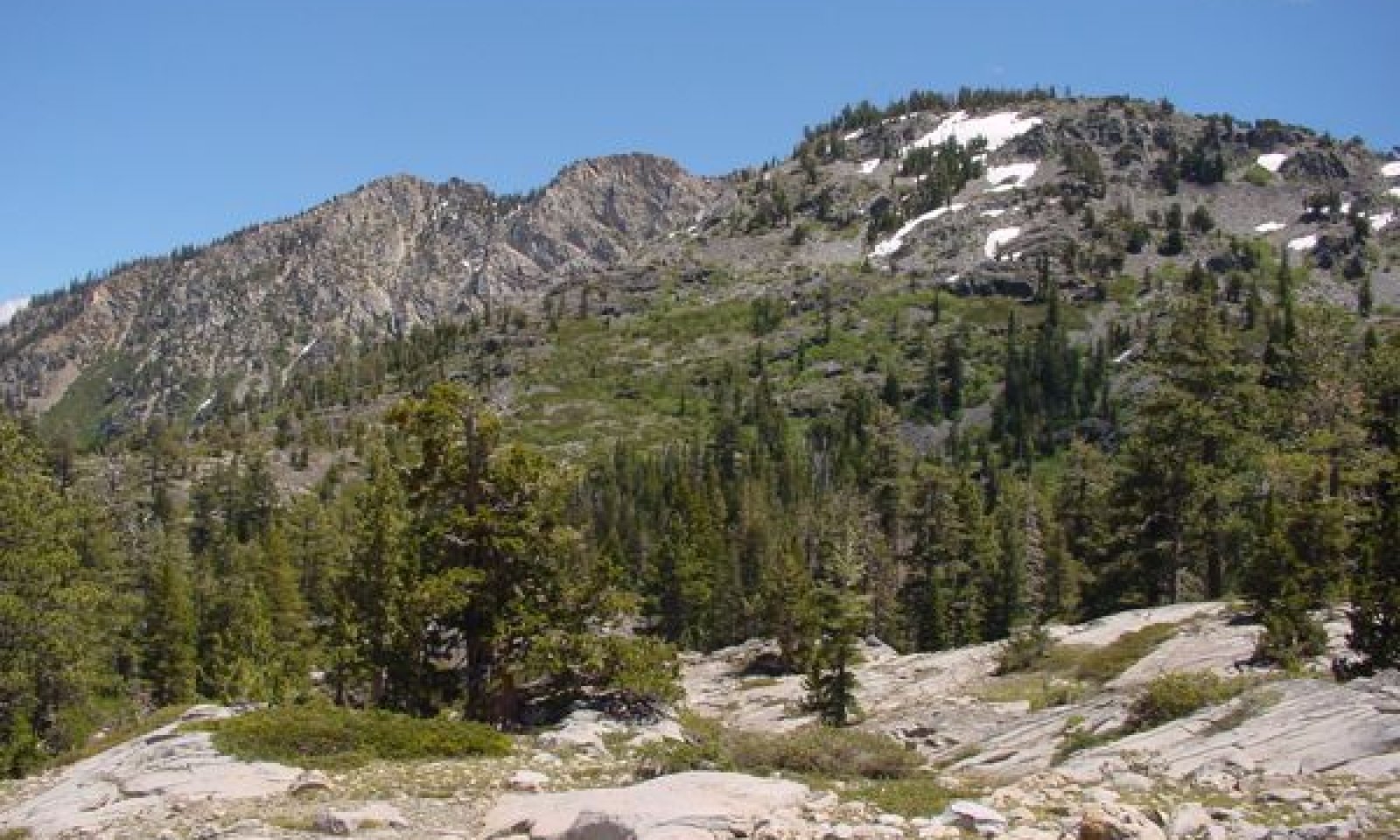
This ecological site occurs in glaciated basins with a very high proportion of bedrock, typically at elevations of 6,300 to 8,200 feet. Slopes range from 5 to 30 percent. Among the bedrock, small pockets of shallow soil and patches of talus support most of the vegetation for this site. The inherent patchiness of the habitat means that there is an inherently high degree of variability in the reference plant community. A low sedge community dominated by Ross sedge (Carex rossii) and shorthair sedge (Carex exserta) typically occurs in flat or gently sloping soil pockets. A shrub community dominated by huckleberry oak (Quercus vaccinifolia) is concentrated close to bedrock and among talus where roots have freedom to grow deep laterally and deep into the talus. A diverse forb community dominated by mountain pride (Penstemon newberryi) occupies the diverse microsites found throughout the site, such as cracks in bedrock, and there is typically a sparse cover of Sierra juniper (Juniperus grandis), Jeffrey pine (Pinus jeffreyi) and Sierra lodgepole pine (Pinus contorta var. murrayana). The trees are typically found adjacent to the exposed bedrock and occasionally in the cracks of the bedrock where water is readily available.
Associated sites
F022AC003CA Frigid-Cryic Sandy Slopes
Occurs on higher elevation slopes with moderately to very deep sandy soils. Red fir (Abies magnifica) and western white pine (Pinus monticola) dominate the forest, with pinemat manzanita (Arctostaphylos nevadensis) dominant in canopy openings.
F022AC005CA Cryic Sheltered, Moist Sandy Mountain Slopes
Occurs on adjacent north-facing slopes with deep sandy soils. A mixed-subalpine forest is present, with Sierra lodgepole pine (Pinus contorta var. murrayana), mountain hemlock (Tsuga mertensiana), red fir (Abies magnifica) and western white pine (Pinus monticola) all present.
F022AF004CA Frigid, Shallow To Deep, Sandy Mountain Slopes
Occurs on adjacent south-facing slopes with sandy soils. Jeffrey pine (Pinus jeffreyi) dominates the open forest, and shrubs may be abundant in the understory.
R022AE213CA Steep Rubbly Slope
Occurs on adjacent steep rubbly slopes and is dominated by a dense huckleberry oak (Quercus vaccinifolia), greenleaf manzanita (Arctostaphylos patula) shrubland.
Table 1. Dominant plant species
Tree (1) Juniperus grandis
(2) Pinus jeffreyiShrub (1) Quercus vacciniifolia
Herbaceous (1) Carex rossii
(2) Carex exsertaPhysiographic features
This site is found on glacially scoured valleys and mountain side slopes at elevations from 6,350 to 9,280 feet, but typically below 8,200 feet. Granite bedrock covers more than 50 percent of the area. Shallow soil pockets are found in depressions or on ledges formed from the bedrock. This site may be found on all aspects, but typically occurs on south to southeast facing slopes. Slopes range from 5 to 30 percent, and runoff is very high.
Table 2. Representative physiographic features
Landforms (1) U-shaped valley
(2) Mountain
Flooding frequency None Ponding frequency None Elevation 6350 – 9280 ft Slope 5 – 30 % Aspect E, S, W Climatic features
The climate of this ecological site is characterized by cool temperatures, wet winters with most precipitation falling as snow in winters, and relatively dry summers. The average annual precipitation ranges from 37 to 65 inches. The average annual air temperature ranges from 40 to 45 degrees Fahrenheit. The frost-free (>32F) season is 50 to 110 days. The freeze-free (>28F) season is 107 to 155 days.
Table 3 Representative climatic features
Frost-free period (average) 130 days Freeze-free period (average) 80 days Precipitation total (average) 50 in BarLineFigure 2. Monthly precipitation range
BarLineFigure 3. Monthly average minimum and maximum temperature
Figure 4. Annual precipitation pattern
Figure 5 Annual average temperature pattern
">Influencing water features
This ecological site is not influenced by wetland or riparian water features. Seasonal snowmelt and summer rainfall can temporarily pond in the granite pockets.
Soil features
The soils associated with this site are very shallow to shallow, with lithic contact at 7 to 20 inches. Soils are derived from colluvium from granitic parent materials. Granitic bedrock is often exposed and has evidence of scraping from glaciation. Soils are found in patches between rock outcrops and large boulders. These soils are excessively drained with moderately rapid to rapid permeability. The soil moisture regime is xeric and the soil temperature regime is frigid. Surface textures are very gravelly loamy sand and gravelly loamy coarse sand. Subsurface textures are very gravelly loamy sand, very gravelly coarse loamy sand, and very gravelly coarse sandy loam. Surface rock fragments smaller than 3 inches in diameter range from 10 to 35 percent, and larger rock fragments range from 15 to 35 percent. Subsurface rock fragments less than 3 inches in diameter range from 22 to 55 percent by volume, and larger rock fragments range from 0 to 8 percent (percent rock fragment by volumes for a depth of 18 inches). The soils correlated with this site are the Rockbound soils (sandy-skeletal, mixed, frigid Lithic Xerorthents ), and Hardtil soils (Loamy-skeletal, mixed, superactive, frigid Humic Lithic Dystroxerepts).
This ecological site has been correlated with the following mapunits and soil components in the Tahoe Basin soil survey area (CA693):
CA693 ; 7501 ; Rock Outcrop-Rockbound complex, 5 to 30 percent slopes ; Rockbound ; very gravelly loam ; 30
CA693 ; 7487 ; Meeks gravelly loamy coarse sand, 5 to 15 percent slopes, rubbly ; Rockbound ; very gravelly loam ; 5
CA693 ; 7488 ; Meeks gravelly loamy coarse sand, 15 to 30 percent slopes, rubbly ; Rockbound ; very gravelly loam ; 5
CA693 ; 9404 ; Dagget very gravelly loamy coarse sand, moist, 5 to 15 percent slopes, rubbly ; Rockbound ; very gravelly loam ; 5
CA693 ; 9405 ; Dagget very gravelly loamy coarse sand, moist, 15 to 30 percent slopes, rubbly ; Rockbound ; very gravelly loam ; 5
CA693 ; 7401 ; Burnlake-Roadcat association, 4 to 30 percent slopes ; Hardtil ; ; 4
CA693 ; 7522 ; Tallac gravelly coarse sandy loam, 15 to 30 percent slopes, very stony ; Rockbound ; very gravelly loam ; 1
Table 4. Representative soil features
Parent material (1) Colluvium – granite
Surface texture (1) Very gravelly loamy sand
(2) Gravelly loamy coarse sand
Family particle size (1) Sandy
Drainage class Excessively drained Permeability class Moderately rapid to rapid Soil depth 7 – 20 in Surface fragment cover <=3" 10 – 35 % Surface fragment cover >3" 15 – 35 % Available water capacity
(0-40in)0.9 – 1.3 in Soil reaction (1:1 water)
(0-40in)5.5 – 6.5 Subsurface fragment volume <=3"
(Depth not specified)22 – 55 % Subsurface fragment volume >3"
(Depth not specified)0 – 8 % Ecological dynamics
Abiotic Factors
This ecological site occurs in glaciated basins with a very high proportion of bedrock. Among the bedrock, small pockets of shallow soil and patches of talus support most of the vegetation for this site. The inherent patchiness of the habitat means that there is an inherently high degree of variability in the reference plant community. A low sedge community dominated by shorthair sedge, but with a diverse mixture of grasses, sedges and annual forbs typically occurs in flat or gently sloping soil pockets. A shrub community dominated by huckleberry oak is concentrated close to bedrock and among talus where roots have freedom to grow deep laterally and deep into the talus. A diverse forb community occupies the diverse microsites found throughout the site, such as cracks in bedrock, and there is typically a sparse cover of western juniper, Jeffrey pine, and Sierra lodgepole pine. The trees are typically found adjacent to the exposed bedrock and occasionally in the cracks of the bedrock where water is readily available
Disturbance factors
This ecological site has a high degree of ecological resilience. High elevations and very shallow to shallow soils means this site has low susceptibility to invasion. The high bedrock cover means that fire is infrequent, and if it does occur, is limited in extent (e.g. Weisberg et al. 2008). Low plant cover and difficult terrain make the site unattractive to livestock grazing. Avalanches may initiate succession by removing trees and shrubs. Drought, especially lack of protective snow cover during winter that exposes shrubs to cold temperatures and wind, may cause dieback of shrubs and trees (NRCS observations). This may worsen in the future if warming trends in the Sierra Nevada continue (e.g. Hayhoe et al. 2004, van Mantgem and Stephenson 2007, Hurteau and North 2008, Safford et al. 2012).
State and transition model
Custom diagramStandard diagram
Figure 6. R022AE202CA
More interactive model formats are also available. View Interactive Models
More interactive model formats are also available. View Interactive Models
Click on state and transition labels to scroll to the respective textEcosystem states
State 1 submodel, plant communities
State 1
Reference StateThe reference state is dominated by granite bedrock and patchy communities of sedge and grass, shrubs, diverse forbs, and scattered trees. Infrequent lightning-initiated fire or avalanche may temporarily remove trees and shrubs, leading to a forb and grass dominated community for a short period of time. Drought may cause dieback in trees and shrubs.
Community 1.1
Reference plant community
Figure 7. Community Phase 1.1
Community Phase 1.1
Soil pockets: A low herbaceous community dominated by Ross sedge and shorthair sedge occupies flat to gently sloping soil pockets amongst bedrock. Sandberg bluegrass (Poa secunda), western needlegrass (Achnatherum occidentale), and Parry’s rush (Juncus parryi) are common associates in this microsite. This community contributes an average 13 percent cover, but may range from 3 to 30 percent cover.
Diverse forbs: A diverse forb community occupies a range of microhabitats in this site, from cracks in bedrock to shaded overhangs. Mountain pride (Penstemon newberryi) is a dominant forb that grows in talus and outcrop ledges, contributing up to 10 percent cover. Other important forb species include spreading phlox (Phlox diffusa), King’s sandwort (Arenaria kingii), frosted buckwheat (Eriogonum incanum), Watson’s spikemoss (Selaginella watsonii), and Sierra stonecrop (Sedum obtusatum ssp. obtusatum). Forbs contribute an average 12 percent cover, ranging from 7 to 24 percent, and contribute the most biodiversity to the site, with a list of 18 frequently encountered species and many more rarely encountered species that are not listed.
Talus: Patches of talus are occupied by a dense shrub community dominated by huckleberry oak. Common secondary shrubs may include pinemat manzanita (Arctostaphylos nevadensis), oceanspray (Holodiscus discolor), rose meadowsweet (Spirea splendens var. splendens), greenleaf manzanita (Arctostaphylos patula), sulphur-flower buckwheat (Eriogonum umbellatum), and bastardsage (Eriogonum wrightii). Shrub cover averages 15 percent, but may range from 1 to 40 percent. Shrub diversity tends to be higher with increasing elevation, or where there is more moisture.
Patchy trees: The tree canopy is open and patchy, averaging 13 percent, and ranging from 1 to 30 percent cover. Western juniper (Juniperus grandis) is the most consistently present tree, contributing most cover, and Jeffery pine (Pinus jeffreyi), and lodgepole pine (Pinus contorta ssp. murrayana) are also common. California red fir (Abies magnifica) and whitebark pine (Pinus albicaulis) may occasionally occur at higher elevations, while white fir (Abies concolor) is occasional at lower elevations.Figure 8. Annual production by plant type (representative values) or group (midpoint values)
Table 5. Annual production by plant type
Plant type Low
(lb/acre)Representative value
(lb/acre)High
(lb/acre)Shrub/Vine 1 40 110 Tree 3 40 100 Forb 35 40 85 Grass/Grasslike 5 25 65 Total 44 145 360 Table 6. Ground cover
Tree foliar cover 0-0% Shrub/vine/liana foliar cover 0-0% Grass/grasslike foliar cover 0-0% Forb foliar cover 0-0% Non-vascular plants 0-0% Biological crusts 0% Litter 10-20% Surface fragments >0.25" and <=3" 20-30% Surface fragments >3" 10-50% Bedrock 30-80% Water 0% Bare ground 0-10% Table 7. Canopy structure (% cover)
Height Above Ground (ft) Tree Shrub/Vine Grass/
GrasslikeForb <0.5 0-1% 1-22% 3-36% 0-20% >0.5 <= 1 0-1% 0-22% 0-4% 7-27% >1 <= 2 0-1% 0-5% 0-2% 0-15% >2 <= 4.5 0-2% 1-44% – – >4.5 <= 13 0-15% 0-20% – – >13 <= 40 1-30% – – – >40 <= 80 0-2% – – – >80 <= 120 – – – – >120 – – – – Community 1.2
Stand Initiation (Provisional)This community phase occurs after fire or avalanche. The community phase is characterized by grass and forb dominance. Trees will largely survive fire due fire tolerance and the low intensity of fire potential in this site, although seedlings and saplings may be killed. Shrubs will be top-killed. The herbaceous community will recover most quickly, and is likely to suffer the least damage due to very low fuel present. Shorthair sedge, Ross sedge, Sandberg bluegrass, western needlegrass, Parry’s rush, and squirreltail (Elymus elymoides) are likely to be top-killed and rapidly resprout. The dominant shrubs are highly flammable, and will be top-killed or killed by fire. Most shrubs will re-sprout from the root crown or from heat scarified seeds, but require two or more years to regain pre-burn coverage. Huckleberry oak is a fire-adapted species that is highly flammable and vigorously resprouts after fire (Howard 1992, Nagal and Taylor 2005). Greenleaf manzanita is also a vigorous resprouter (Hauser 2007). Oceanspray and rose meadowsweet are moderately adapted to fire and will typically resprout (Esser 1995, Fryer 2010). Sulfur-flowered buckwheat may resprout within 2 years after fire (Rau et al. 2008). Pinemat manzanita is killed by fire, but likely has fire-adapted seeds that will germinate in the first year post-fire (Howard 1993). Little data is available on specific fire responses of the forbs of this site. Many forbs, such as mountain pride, may escape severe burning due to their location in bedrock cracks and ledges. If killed by fire, American rockbrake (Cryptogramma acrostichoides), lace lipfern (Cheilanthes gracillima), and Watson’s spikemoss would reestablish in a year or two from wind-blown spores. Most adult trees will remain standing after fire in this site, although saplings and seedlings are more vulnerable to fire. Adult Jeffrey pine and even saplings are likely to survive the low intensity fire that would occur in this site, although seedlings may be killed (Gucker 2007). Large Sierra juniper are likely to survive fire, but smaller trees and saplings are likely to be killed (Tirmenstein 1999). Sierra lodgepole pine will most likely be killed by fire (Cope 1993).
Avalanche is more likely to remove trees from this site than fire. Avalanche also may remove shrubs, leaving behind a herbaceous community from which succession would occur. The dominant shrubs are capable of resprouting after mechanical damage, as well as fire, so if root crowns survive avalanche, re-colonization will follow a similar course as after fire.
Community 1.3
Drought Impacted (Provisional)This community is characterized by standing dead trees and shrubs. Dormant herbaceous vegetation dominates the site. Widespread conifer mortality due to drought has been observed throughout the Sierra Nevada in recent decades (e.g. Shainsky and Radosevich 1986, Millar et al. 2007, van Mantgem and Stephenson 2007). Drought may kill trees outright, or may make them more susceptible to bark beetle attack. Recent observations throughout the central and southern Sierra have seen widespread shrub mortality that is thought to be caused primarily by reduced winter snowpack, which exposes shrubs to freezing temperatures and winds. Data is not available on community dynamics occurring in this site due to drought impacts, and the length of time necessary for shrub recovery is unknown.
Pathway 1.1a
Community 1.1 to 1.2Occurs with lightning strikes or avalanche.
Pathway 1.1b
Community 1.1 to 1.3Occurs with severe drought.
Pathway 1.2a
Community 1.2 to 1.1With time, the shrubs will continue to increase in size and cover.
Pathway 1.3a
Community 1.3 to 1.1Occurs with a return to average to above average precipitation patterns.
Pathway 1.3b
Community 1.3 to 1.2Occurs with lightning strike or avalanche.
Additional community tables
Table 8. Community 1.1 plant community composition
Group Common name Symbol Scientific name Annual production () Foliar cover (%) Shrub/Vine1 Shrubs 1–110 huckleberry oak QUVA Quercus vacciniifolia 1–110 1–36 pinemat manzanita ARNE Arctostaphylos nevadensis 0–30 1–36 rose meadowsweet SPSPS Spiraea splendens var. splendens 0–10 0–4 oceanspray HODI Holodiscus discolor 0–10 0–4 greenleaf manzanita ARPA6 Arctostaphylos patula 0–3 0–1 sulphur-flower buckwheat ERUM Eriogonum umbellatum 0–3 0–1 bastardsage ERWR Eriogonum wrightii 0–3 0–1 Tree2 Trees 35–85 Sierra lodgepole pine PICOM Pinus contorta var. murrayana 0–50 0–10 western juniper JUGR7 Juniperus grandis 0–20 2–11 Jeffrey pine PIJE Pinus jeffreyi 0–20 0–9 Grass/Grasslike3 Grasses and Grasslike 5–65 Ross' sedge CARO5 Carex rossii 12–60 1–5 shorthair sedge CAEX4 Carex exserta 3–45 1–30 western needlegrass ACOC3 Achnatherum occidentale 0–6 0–1 Sandberg bluegrass POSE Poa secunda 0–5 0–1 squirreltail ELEL5 Elymus elymoides 0–1 0–1 Parry's rush JUPA Juncus parryi 0–1 0–1 pullup muhly MUFI2 Muhlenbergia filiformis 0–1 0–1 Forb4 Forbs 35–85 mountain pride PENE3 Penstemon newberryi 1–40 1–10 frosted buckwheat ERIN9 Eriogonum incanum 0–9 0–1 King's sandwort ARKI Arenaria kingii 0–3 0–1 spreading phlox PHDI3 Phlox diffusa 0–3 0–1 whiskerbrush LECIC2 Leptosiphon ciliatus ssp. ciliatus 0–2 0–1 scabland penstemon PEDE4 Penstemon deustus 0–1 0–1 lambstongue ragwort SEIN2 Senecio integerrimus 0–1 0–1 Sierra stonecrop SEOBO Sedum obtusatum ssp. obtusatum 0–1 0–1 Watson's spikemoss SEWA2 Selaginella watsonii 0–1 0–1 shieldplant STTO3 Streptanthus tortuosus 0–1 0–1 prettyface TRIX Triteleia ixioides 0–1 0–1 smokey mariposa CALE3 Calochortus leichtlinii 0–1 0–1 lace lipfern CHGR Cheilanthes gracillima 0–1 0–1 Torrey's blue eyed Mary COTO Collinsia torreyi 0–1 0–1 American rockbrake CRAC3 Cryptogramma acrostichoides 0–1 0–1 naked buckwheat ERNU3 Eriogonum nudum 0–1 0–1 dusky onion ALCA2 Allium campanulatum 0–1 0–1 rockcress ARABI2 Arabis 0–1 0–1 Table 9. Community 1.2 plant community composition
Group Common name Symbol Scientific name Annual production () Foliar cover (%) Table 10. Community 1.3 plant community composition
Group Common name Symbol Scientific name Annual production () Foliar cover (%) Interpretations
Animal community
Birds, small mammals, bear and deer utilize this area.
Western juniper berries are eaten by wildlife. The trees provide cover and nest sites.Recreational uses
Hiking, biking, backpacking, fishing, and swimming are common activities in this area.
Wood products
This area is difficult to access. Tree growth is slow, and coverage is sparse. Therefore, this area is not desirable for harvesting.
Supporting information
Inventory data references
The following TEUI plots done for the Tahoe Basin NRCS soil survey were used to define this ecological site. Community Phase 1.1: ra02005 (Type location) rx03303 ra02h27a ra03008 rx03045 rx03050 ra03106 ra02h14 ra03032 AB39
Type locality
Location 1: El Dorado County, CA UTM zone N UTM northing 4306481 UTM easting 751637 General legal description Take Hwy 89 North from South Lake Tahoe, turn left of Fallen Leaf Lake Rd. to Glen Alpine Springs trailhead. Head up the trail and the site is just south of the trail in a rock outcrop area, just before Grass Lake Trail junction. Other references
Cope, A. B. 1993. Pinus contorta var. murreyana. Fire Effects Information System. U.S. Department of Agriculture, Forest Service, Rocky Mountain Research Station, Fire Sciences Laboratory.
Esser, L. L. 1995. Spirea douglasii. Fire Effects Information System. U.S. Department of Agriculture, Forest Service, Rocky Mountain Research Station, Fire Sciences Laboratory.
Fryer, J. L. 2010. Holodiscus discolor. Fire Effects Information System. U.S. Department of Agriculture, Forest Service, Rocky Mountain Research Station, Fire Sciences Laboratory.
Gucker, C. L. 2007. Pinus jeffreyi. Fire Effects Information System. U.S. Department of Agriculture, Forest Service, Rocky Mountain Research Station, Fire Sciences Laboratory.
Hauser, A. S. 2007. Arctostaphylos patula. Fire Effects Information System. U.S. Department of Agriculture, Forest Service, Rocky Mountain Research Station, Fire Sciences Laboratory.
Hayhoe, K., D. Cayan, C. B. Field, P. C. Frumhoff, E. P. Maurer, N. L. Miller, S. C. Moser, S. H. Schneider, K. N. Cahill, E. E. Cleland, L. Dale, R. Drapek, R. P. Hanemann, L. S. Kalkstein, J. Lenihan, C. K. Lunch, R. P. Neilson, S. C. Sheridan, and J. H. Verville. 2004. Emissions pathways, climate change, and impacts on California. PNAS 101:12422-12427.
Howard, J. L. 1992. Quercus vaccinifolia. Fire Effects Information System. U.S. Department of Agriculture, Forest Service, Rocky Mountain Research Station, Fire Sciences Laboratory.
Howard, J. L. 1993. Arctostaphylos nevadensis. Fire Effects Information System. U.S. Department of Agriculture, Forest Service, Rocky Mountain Research Station, Fire Sciences Laboratory.
Hurteau, M. and M. North. 2008. Mixed-conifer understory response to climate change, nitrogen, and fire. Global Change Biology 14:1543-1552.
Millar, C. I., R. D. Westfall, and D. D. Delany. 2007. Response of high-elevation limber pine (Pinus flexilis) to multiyear droughts and 20th-century warming, Sierra Nevada, California, USA. Canadian Journal of Forest Research 37:2508-2520.
Nagal, T. A. and A. H. Taylor. 2005. Fire and persistence of montane chaparral in mixed conifer forest landscapes in the northern Sierra Nevada, Lake Tahoe Basin, California, USA. Journal of the Torrey Botanical Society 132:442-457.
Rau, B. M., J. C. Chambers, R. R. Blank, and D. W. Johnson. 2008. Prescribed fire, soil, and plants: burn effects and interactions in the central Great Basin. Rangeland Ecology and Management 61:169-181.
Safford, H. D., M. North, and M. D. Meyer. 2012. Climate change and the relevance of historical forest conditions. Pages 23-45 in M. North, editor. Managing Sierra Forests. U.S. Department of Agriculture, Forest Service, Pacific Southwest Research Station, Albany, CA.
Shainsky, L. J. and S. R. Radosevich. 1986. Growth and water relations of Pinus ponderosa seedlings in competitive regimes with Arctostaphylous patula seedlings. Journal of Applied Ecology 23:957-966.
Tirmenstein, D. 1999. Juniperus occidentalis. Fire Effects Information System. U.S. Department of Agriculture, Forest Service, Rocky Mountain Research Station, Fire Sciences Laboratory.
van Mantgem, P. J. and N. L. Stephenson. 2007. Apparent climatically-induced increase of tree mortality rates in a temperate forest. Ecology Letters 10:909-916.
Weisberg, P. J., D. Ko, C. Py, and J. M. Bauer. 2008. Modeling fire and landform influence on the distribution of old-growth pinyon-juniper woodland. Landscape Ecology 8:931-943.
Contributors
Alice Miller
Marchel M. MunneckeRangeland health reference sheet
Interpreting Indicators of Rangeland Health is a qualitative assessment protocol used to determine ecosystem condition based on benchmark characteristics described in the Reference Sheet. A suite of 17 (or more) indicators are typically considered in an assessment. The ecological site(s) representative of an assessment location must be known prior to applying the protocol and must be verified based on soils and climate. Current plant community cannot be used to identify the ecological site.
Author(s)/participant(s) Contact for lead author Date Approved by Approval date Composition (Indicators 10 and 12) based on Annual Production Indicators
-
Number and extent of rills:
-
Presence of water flow patterns:
-
Number and height of erosional pedestals or terracettes:
-
Bare ground from Ecological Site Description or other studies (rock, litter, lichen, moss, plant canopy are not bare ground):
-
Number of gullies and erosion associated with gullies:
-
Extent of wind scoured, blowouts and/or depositional areas:
-
Amount of litter movement (describe size and distance expected to travel):
-
Soil surface (top few mm) resistance to erosion (stability values are averages - most sites will show a range of values):
-
Soil surface structure and SOM content (include type of structure and A-horizon color and thickness):
-
Effect of community phase composition (relative proportion of different functional groups) and spatial distribution on infiltration and runoff:
-
Presence and thickness of compaction layer (usually none; describe soil profile features which may be mistaken for compaction on this site):
-
Functional/Structural Groups (list in order of descending dominance by above-ground annual-production or live foliar cover using symbols: >>, >, = to indicate much greater than, greater than, and equal to):
Dominant:
Sub-dominant:
Other:
Additional:
-
Amount of plant mortality and decadence (include which functional groups are expected to show mortality or decadence):
-
Average percent litter cover (%) and depth ( in):
-
Expected annual annual-production (this is TOTAL above-ground annual-production, not just forage annual-production):
-
Potential invasive (including noxious) species (native and non-native). List species which BOTH characterize degraded states and have the potential to become a dominant or co-dominant species on the ecological site if their future establishment and growth is not actively controlled by management interventions. Species that become dominant for only one to several years (e.g., short-term response to drought or wildfire) are not invasive plants. Note that unlike other indicators, we are describing what is NOT expected in the reference state for the ecological site:
-
Perennial plant reproductive capability:
Print Options
Sections
Font
AAAAOther
PrintThe Ecosystem Dynamics Interpretive Tool is an information system framework developed by the USDA-ARS Jornada Experimental Range, USDA Natural Resources Conservation Service, and New Mexico State University.
Accessibility statement


