
Natural Resources
Conservation Service
-
Search


Major Land Resource Area or ecological site by name and/or ID.
PreviousSectionsNextGeneral information
Draft. A draft ecological site description is either incomplete or has not undergone quality control and quality assurance review.
MLRA notes
Major Land Resource Area (MLRA): 022A–Sierra Nevada and Tehachapi Mountains
Major Land Resource Area 22A, Sierra Nevada Mountains, is located predominantly in California and a small section of western Nevada. The area lies completely within the Sierra Nevada Section of the Cascade-Sierra Mountains Province. The Sierra Nevada range has s gentle western slope, and a very abrupt eastern slope. The Sierra Nevada consists of hilly to steep mountains and occasional flatter mountain valleys. Elevation ranges between 1,500 and 9,000 ft. throughout most of the range, but peaks often exceed 12,000 ft. The highest point in the continental US occurs in this MLRA (Mount Whitney, 14,494 ft.). Most of the Sierra Nevada is dominated by granitic rock known as the Sierra Nevada Batholith. Additionally, glacial activity of the Pleistocene has played a major role in shaping Sierra Nevada features, including cirques, arêtes, and glacial deposits and moraines. Average annual precipitation ranges from 20 to 80 inches in most of the area, with increases along elevational and south-north gradients. Soil temperature regime ranges from mesic, frigid, and cryic. Due to the extreme elevational range found within this MLRA, Land Resource Units (LRUs) were designated to group the MLRA into similar land units.
LRU "B" Southern Sierra Subalpine
The Southern Sierra subalpine LRU "B" occurs south of latitude 39 degrees north, at elevations typically between 9,000 to 10,500 feet (2,743 to 3,200 m). MAAT ranges from 31 to 40 degrees F (-0.5 to 4.4 C), MAP ranges from 32 to 59 inches (813 to 1,499 mm), and the frost-free season is 25 to 60 days. Forests are dominated by whitebark pine (Pinus albicaulis) and foxtail pine (Pinus balfouriana) near timberline, and a mix of Sierra lodgepole pine (Pinus contorta var. murrayana), whitebark pine, and/or mountain hemlock (Tsuga mertensiana) at the lower elevations. Threadleaf sedge (Carex filifolia) or purple mountainheath (Phyllodoce breweri) dominate non-forested areas.Ecological site concept
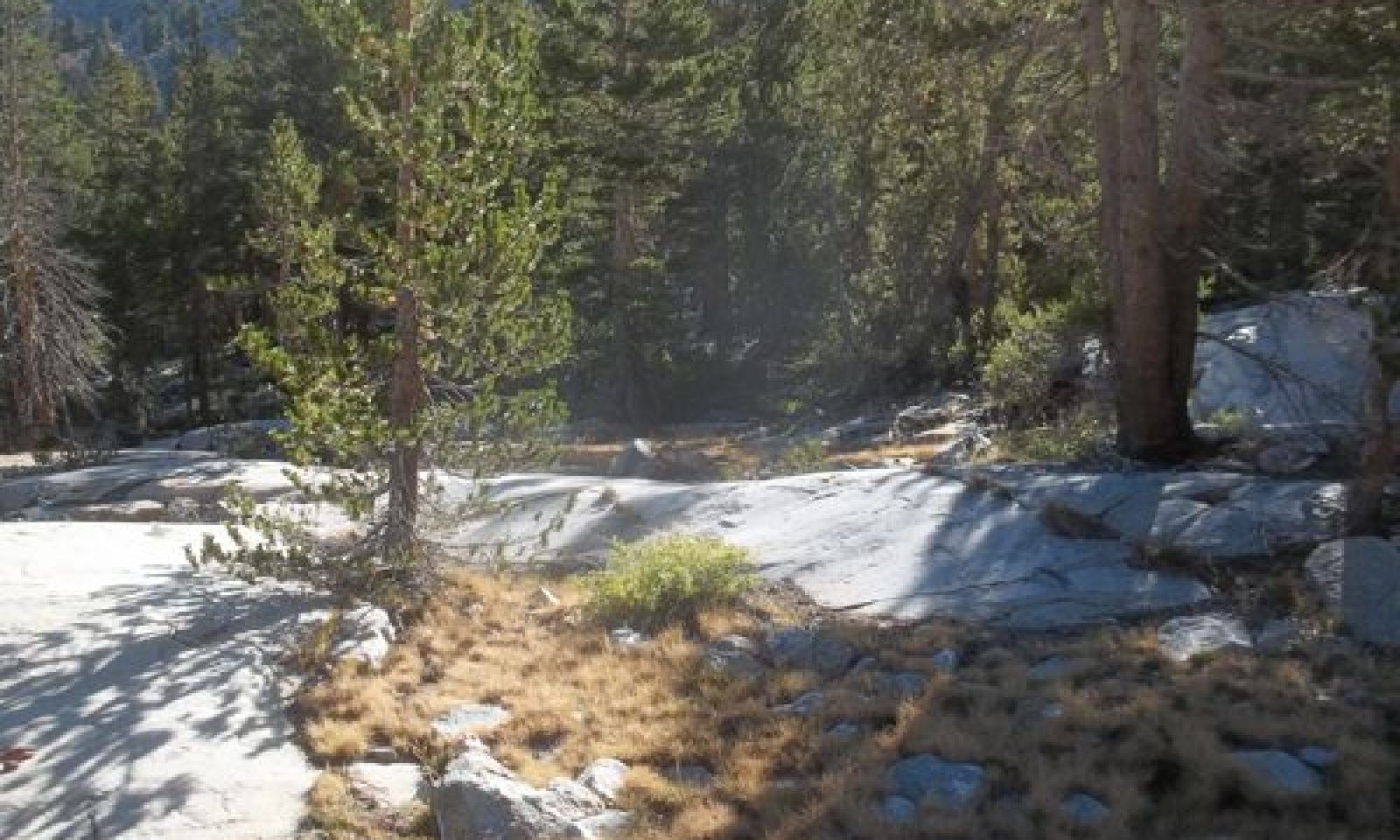
This ecological site occurs on shallow soil pockets among jointed granitic bedrock on scoured mountain slopes and benches at elevations of 8700 to 11,000 feet. Soil pockets typically have an umbric or ochcric epipedon and loamy textures. Threadleaf sedge is strongly dominant, and forms dense sods. Forb and shrub cover is sparse. There is a low cover of small statured Sierra lodgepole pine.
Table 1. Dominant plant species
Tree (1) Pinus contorta var. murrayana
Shrub Not specified
Herbaceous (1) Carex filifolia
Physiographic features
Table 2. Representative physiographic features
Climatic features
">Influencing water features
Soil features
Ecological dynamics
This ecological site occurs on shallow soil pockets among jointed granitic bedrock on scoured mountain slopes and benches at elevations of x to x feet. Soil pockets typically have an umbric or ochcric epipedon and loamy textures. Threadleaf sedge is strongly dominant, and forms dense sods. Forb and shrub cover is sparse. There is a low cover of small statured Sierra lodgepole pine.
Threadleaf sedge dry meadows are widespread in subalpine and alpine habitats in the Sierra Nevada and often occur on warm, dry south-facing aspects on gravelly soils (Ratliff 1974,Vankat and Major 1978, Burke 1982, Jackson and Bliss 1982, Ratliff 1985b, Hauser 2006, Fites-Kaufmann et al. 2007). These meadows receive early season moisture from runoff, snowmelt and precipitation (Weixelman et al. 2011). Threadleaf sedge is a cool season species, which uses the early season moisture on this site for growth, then goes dormant for the summer dry period (Ratliff 1974). Threadleaf sedge forms a dense sod in moderately deep pockets, with a dense mat of roots that extend 1.5 m into the soil, or to root restriction for shallower soil, and which makes it difficult for other species to compete.
Disturbance/Ecological factors
Tree invasion, drought, livestock grazing, recreational impacts and global climate change are the primary disturbances impacting this ecological site. Although lightning strikes may initiate fire, the low fuel loads of this site mean that fire is highly unlikely to carry.
Historically these meadows would have been lightly to moderately grazed by native wildlife, including bighorn sheep, deer, and small mammals (Ratliff 1982). Starting in the late 1800’s and until the 1930s they were intensively grazed by sheep (e.g. Ratliff 1974, Vankat and Major 1978, Benedict 1983, Ratliff 1985a, Odion et al. 1988), and most contemporary Sierra Nevada meadows are either recovering from grazing or are still grazed by pack animals, with few if any pristine examples (Benedict 1983). Damage from sheep grazing is still apparent in threadleaf sedge meadows, with decreased foliar cover, increased bare ground, pedestalling of sod, and erosion of soil and sod (Vankat and Major 1978, Ratliff 1982, 1985a, Odion et al. 1988), with only patches of vegetation in some meadows (Vankat and Major 1978, Odion et al. 1988). In the 1970s a sample of 10 shorthair sedge meadows in Kings Canyon National Park had a mean foliar cover of 29 percent, while an island meadow presumably free of grazing had a foliar cover of 70 percent, and four times the standing biomass of previously grazed sites (Ratliff 1974). A comparison of historic photos showed little recovery in 70 years. We measured an average foliar cover of 60 percent in meadows judged to be in good condition, and 29 percent in degraded meadows. Although sheep haven’t grazed these meadows since the 1930s, recreational pack stock continue to do so. A study of the impacts of pack animals on shorthair sedge meadows in Yosemite showed a mean reduction in biomass of 18 percent, with a seven percent increase in bare ground and a decline in relative graminoid cover (Cole et al. 2004). The authors recommend utilization below 35 percent.
There is little literature available about recreational impacts specific to this ecological site. The vegetation of this site is relatively resistant to trampling, however, once destroyed it is very slow to recover (Eagan et al. 2000, Ratliff, 1985). The coarse textures typical of threadleaf sedge meadows have low soil fertility, and dry summer conditions are not conducive to seedling establishment. Subalpine dry meadows dominated by threadleaf sedge in Yosemite National Park were damaged by hiking trails, with development of multiple trail ruts that caused soil erosion and altered hydrology (Eagan et al. 2000). Soil erosion was greater on slopes over 4 percent, and where soil loss was 10-20 cm (Eagan et al. 2000). Highly popular backcountry trails such as the John Muir Trail/Pacific Crest Trail pass through this site, which offers ideal camping spots with flat ground, a little bit of shelter with the sparse trees that are mixed in with this site, and scenic outcrops. The attractiveness of these sites for humans is demonstrated by frequent evidence of Native American use in these sites. Repeated tent placements destroy vegetation, creating bare patches, and trampling creates trails, destroys or reduces vegetation and compacts soils, making them susceptible to erosion (Boyle and Samson 1985, Price 1985).
An ongoing pattern of warming and decreased snowpack is predicted under global climate change scenarios for the Sierra Nevada (e.g Hayhoe et al. 2004, Safford et al. 2012). Recent California based climate models predict a 9 degree F increase in temperature by 2100, and more conservative models predict a 2 to 4 degree F increase in winter and 4 to 8 degree increase in summer (Safford et al. 2012). Models are more variable for precipitation, but recent models for the Sierra Nevada, predict similar to slightly less precipitation. Most models agree that summers will become drier, since more of the precipitation is predicted to come as rain, and snow melt-off will occur earlier in spring (Hayhoe et al. 2004, Safford et al. 2012). Alpine areas have been called bellwhethers for global climate change impacts (e.g. Seastedt et al. 2004), due to a highly specialized flora and fauna that may not compete well with a lessening of harsh environmental conditions, and no higher elevations to retreat. However, unidirectional change may not be realistic. Microtopographic variation may allow for within site or more local migrations (Gibson et al. 2008, Spasojevic et al. 2013). Xeric community types such as shorthair sedge meadows, may expand into previously moister locations with increased warming and reduced precipitation (Spasojevic et al. 2013). Long-term studies of dry meadows in Colorado have shown these dry systems to be fairly resilient to change, with impermanent transitions occurring in response to annual variations in climate (Johnson et al. 2011, Spasojevic et al. 2013). However, while communities are not being lost, there is an overall trend of increased diversity as species from lower elevations move up, and in time, these species may outcompete the locals (Johnson et al. 2011, Spasojevic et al. 2013). In this ecological site, shorthair sedge would likely remain dominant, but the associated forbs, subshrubs and trees that are more strongly adapted to high elevations might be lost. Since the specific changes that will occur with global climate change are currently unknown for this site, climate change impacts are not included in the state-and-transition model.
All tabular data listed for a specific community phase within this ecological site description represent a summary of one or more field data collection plots taken in communities within the community phase. Although such data are valuable in understanding the phase (kinds and amounts of ground and surface materials, canopy characteristics, community phase overstory and understory species, production and composition, and growth), it typically does not represent the absolute range of characteristics nor an exhaustive listing of species for all the dynamic communities within each specific community phase.State and transition model
More interactive model formats are also available. View Interactive Models
Click on state and transition labels to scroll to the respective textState 1 submodel, plant communities
State 2 submodel, plant communities
State 3 submodel, plant communities
State 1
Reference (Provisional)The historic state represents unmodified, pre-European conditions. Grazing was by native wildlife only. Temporary use by Native Americans occurred during summer. Data is not available for this state.
Community 1.1
Reference CommunityData is not available to describe this site, but it likely had higher vegetative cover than the reference plant community (2.1).
State 2
RepresentativeThe current reference state represents vegetation recovering from widespread heavy sheep grazing at the turn of the 19th century, and may still be used by pack stock and for backcountry camping.
Community 2.1
Representative Community
Figure 1. Community phase 2.1
A low statured grassland strongly dominated by shorthair sedge sod dominates the reference plant community. Foliar cover averages 52 percent, with graminoids averaging 41 percent, forbs 5.5 percent, and trees 5.5 percent. Sparse shrubs may be present. Sandbery bluegrass (Poa secunda), Parry’s rush (Juncus parryi), and Ross’ sedge (Carex rossii) are important secondary graminoids. Forbs are sparse in the high competition environment. Frequently occurring species include Rydberg’s penstemon (Penstemon rydbergii), mountain pride (Penstemon newberryi), Watson’s spikemoss (Selaginella watsonii), rosy pusstoes (Antennaria rosea), and alpine sheep sorrel (Rumex paucifolius), although different species may occur at a given location. Gooseberry current (Ribes montigenum) is the most frequently encountered shrub in this site, and may be sparsely present. Short-statured Sierra lodgepole pine is present at 3 to 20 percent cover.
Figure 2. Annual production by plant type (representative values) or group (midpoint values)
Table 3. Annual production by plant type
Plant type Low
(lb/acre)Representative value
(lb/acre)High
(lb/acre)Grass/Grasslike 245 325 405 Forb 15 20 25 Tree 7 9 11 Shrub/Vine 0 0 4 Total 267 354 445 Table 4. Canopy structure (% cover)
Height Above Ground (ft) Tree Shrub/Vine Grass/
GrasslikeForb <0.5 – – 31-55% 2-5% >0.5 <= 1 – 0-1% 2-10% 2-10% >1 <= 2 0-1% 0-1% 1-10% 1-10% >2 <= 4.5 0-1% 0-1% – – >4.5 <= 13 0-2% – – – >13 <= 40 2-20% – – – >40 <= 80 0-3% – – – >80 <= 120 – – – – >120 – – – – Community 2.2
Degraded (Provisional)This community phase is characterized by reduced foliar cover and productivity, increased bare ground or gravels, and evidence of plant pedestalling and soil erosion. This community may occur due to degradation of the current reference community, or may represent slower recovery of more severely degraded sites from turn of the century grazing.
Community 2.3
Tree dominant
Figure 3. Tree dominant community phase
This community phase occurs when Sierra lodgepole pine invades the threadleaf sedge community, shading out the sedge and resulting in a tree dominant community with little herbaceous cover.
Pathway 2.1a
Community 2.1 to 2.2Occurs with pack grazing above sustainable levels for this site. These impacts will be greater during drought, when vegetative cover is already compromised. It may also occur with recreational camping use.
Pathway 2.1b
Community 2.1 to 2.3
Representative Community
Tree dominantThis pathway occurs with tree invasion, or growth that overtops the threadleaf sedge community, leading to a decline in this community. Degradation of the site by grazing or camping may make it more vulnerable to tree invasion, as may wet warm climatic periods.
Pathway 2.2a
Community 2.2 to 2.1This pathway occurs with time without grazing/camping.
Pathway 2.2b
Community 2.2 to 2.3This pathway occurs with tree invasion, or tree growth that overtops the threadleaf sedge dominated community, leading to shading out and decline of this community. This phase may be more vulnerable to tree invasion due to lower threadleaf sedge cover.
Pathway 2.3a
Community 2.3 to 2.1
Tree dominant
Representative CommunityOccurs with the removal of tree canopy that allows for recolonization by threadleaf sedge. Tree removal may occur due to windthrow, fire, or by manual removal.
Pathway 2.3b
Community 2.3 to 2.2This pathway occurs with recreational overuse of the tree dominant phase. Recurrent tent pads and trampling may compact soils and lead to soil erosion, so that it is difficult for threadleaf sedge recolonization to occur. This may shift this site to an altered eroded state.
State 3
Eroded (Provisional)This degraded state occurs after grazing or recreational impacts are severe enough that active restoration is required for recovery. Bare gravels or soil dominate, with vegetation largely denuded. Livestock or social trails are prevalent. There is significant soil erosion. Data is not available for this state, but descriptions of these conditions exist in the literature (e.g. Price, 1985, Ratliff 1974, 1985a, b).
Community 3.1
Eroded (Provisional)Transition 1
State 1 to 2This transition occurred with widespread, intensive sheep grazing throughout the Sierra Nevada at the turn of the 19th century. The majority of Sierran meadows were impacted by this grazing, and are still recovering.
Transition 1
State 1 to 2This transition occurred with widespread, intensive sheep grazing throughout the Sierra Nevada at the turn of the 19th century. The majority of Sierran meadows were impacted by this grazing, and are still recovering (e.g. Benedict 1983).
Restoration pathway 1
State 3 to 2Active restoration including seeding or outplanting may be used to revegetate barren areas. Threadleaf sedge plugs and fertilizer addition have been used experimentally to restore damaged meadows in the Siberian outpost area of Kings Canyon National Park (Ratliff 1985b). Transplanting large, unfertilized, unspotted plugs of sod was found to be most successful. Fertilization had neutral or negative effects on plug survival, and had negative effects on density of existing vegetation. Plugs of shorthair sedge and Parry’s rush were also to restore trail ruts in Yosemite National Park (Eagan et al. 2000). Five years after restoration, the cover on restored areas had increased from barren to about half the cover of undisturbed meadow plots, indicating restoration was happening, but slowly. Meadows must be kept free of grazing or other disturbance until restoration is complete.
Additional community tables
Table 5. Community 1.1 plant community composition
Group Common name Symbol Scientific name Annual production () Foliar cover (%) Table 6. Community 2.1 plant community composition
Group Common name Symbol Scientific name Annual production () Foliar cover (%) Grass/Grasslike1 Grasses/Grasslikes 245–405 threadleaf sedge CAFI Carex filifolia 200–335 35–46 Sandberg bluegrass POSE Poa secunda 2–40 1–4 Parry's rush JUPA Juncus parryi 2–20 1–6 Ross' sedge CARO5 Carex rossii 1–15 1–3 Forb2 Forbs 15–25 mountain pride PENE3 Penstemon newberryi 0–30 0–3 Watson's spikemoss SEWA2 Selaginella watsonii 1–8 0–3 Rydberg's penstemon PERY Penstemon rydbergii 0–4 0–2 alpine sheep sorrel RUPA6 Rumex paucifolius 0–2 0–1 rosy pussytoes ANRO2 Antennaria rosea 0–1 0–1 Shrub/Vine3 Shrubs 0–4 gooseberry currant RIMO2 Ribes montigenum 0–4 0–1 Tree4 Trees 1–30 Sierra lodgepole pine PICOM Pinus contorta var. murrayana 1–30 3–20 Table 7. Community 2.2 plant community composition
Group Common name Symbol Scientific name Annual production () Foliar cover (%) Table 8. Community 2.3 plant community composition
Group Common name Symbol Scientific name Annual production () Foliar cover (%) Table 9. Community 3.1 plant community composition
Group Common name Symbol Scientific name Annual production () Foliar cover (%) Interpretations
Supporting information
Inventory data references
High intensity sampling (Caudle et al. 2013) was used to describe this ecological site. Site characteristics such as aspect, slope, elevation and UTMS were recorded for each plot, along with complete species inventory by ocular percent cover. The line-point intercept method was used to measure foliar cover, groundcover, and vegetation structure. At 100 points along a 400-foot step transect, ground cover and intercepted plant species were recorded by height. The first hit method (Herrick et al. 2009) was used to generate the foliar cover values entered in the community phase composition tables. Annual production was estimated using the double-weight sampling method outlined in the National Range and Pasture Handbook and in Sampling Vegetation Attributes (NRCS 2003 and Interagency Technical Reference 1999 pgs. 102 - 115). For herbaceous vegetation, ten 9.6 square foot circular sub-plots were evenly distributed along a 200 foot transect. For woody and larger herbaceous species production was estimated in four 21’X21’ square plots along the same transect. Weight units were collected for each species encountered in the production plots. The number of weight units for each species is then estimated for all plots. Community Phase 2.1: 2013CA7921052 2013CA7921063 2012CA7925013
Other references
Benedict, N. B. 1983. Plant associations of subalpine meadows, Sequoia National Park, California. Arctic and Alpine Research 15:383-396.
Boyle, S. A. and F. B. Samson. 1985. Effects of nonconsumptive recreation on wildlife: a review. Wildlife Society Bulletin 13:110-116.
Burke, M. T. 1982. The vegetation of the Rae Lakes Basin, southern Sierra Nevada. Madroño 29:164-176.
Cole, D. N., J. V. Wagtendonk, M. P. McClaren, P. E. Moore, and N. K. McDougald. 2004. Response of mountain meadows to grazing by recreational pack stock. Journal of Range Management 57:153-160.
Eagan, S., P. Newman, S. Fritzke, and L. Johnson. 2000. Restoration of multiple-rut trails in the Tuolumne Meadows of Yosemite National Park. Pages 188-192 in D. N. Cole, S. F. McCool, W. T. William, and J. O'Loughlin, editors. Wilderness science in a time of change conference-Volume 5: Wilderness ecosystems, threats, and management. USDA Forest Service, Rocky Mountain Research Station, Ogden, UT.
Fites-Kaufmann, J. A., P. Rundel, N. Stephenson, and D. A. Weixelman. 2007. Montane and subalpine vegetation of the Sierra Nevada and Cascade ranges. Pages 456-501 Terrestrial vegetation of California. University of California Press, Berkeley.
Hauser, A. S. 2006. Carex filifolia. Fire Effects Information System, [Online]. U.S. Department of Agriculture, Forest Service, Rocky Mountain Research Station, Fire Sciences Laboratory.
Hayhoe, K., D. Cayan, C. B. Field, P. C. Frumhoff, E. P. Mauren, N. L. Miller, S. C. Moser, S. H. Schneider, K. N. Cahill, E. E. Cleland, L. Dale, R. Drapek, R. M. Hanemann, L. S. Kalkstein, J. Lenihan, C. K. Lunch, R. P. Neilson, S. C. Sheridan, and J. H. Verville. 2004. Emissions pathways, climate change, and impacts on California. Proceedings of the National Academy of Sciences 101.
Jackson, L. E. and L. C. Bliss. 1982. Distribution of ephemeral herbaceous plants near treeline in the Sierra Nevada, California, U.S.A. Arctic and Alpine Research 14:33-42.
Klikoff, L. G. 1965. Microenvironmental influence of vegetational pattern near timberline in the central Sierra Nevada. Ecological Monographs 35:187-211.
Odion, D. C., T. L. Dudley, and C. M. D'Antonio. 1988. Cattle grazing in southeastern Sierran meadows: ecosystem chane and prospects for recovery. Pages 277-292 Plant biology of eastern California. White Mountain Research Station, University of California, Los Angeles.
Price, M. F. 1985. Impacts of recreational activities on alpine vegetation in western North America. Mountain Research and Development 5:263-277.
Ratliff, R. D. 1974. Short-hair sedge--its condition in the high Sierra Nevada of California. Forest Service, US Dept. of Agriculture, Pacific Southwest Forest and Range Experiment Station.
Ratliff, R. D. 1982. Nutrients in Carex exserta sod and gravel in Sequoia National Park, California. Western North American Naturalist 45:61-66.
Ratliff, R. D. 1985a. Meadows in the Sierra Nevada of California: state of knowledge. United States Department of Agriculture, U.S. Forest Service, Pacific Southwest Forest and Range Experiment Station, Berkeley, CA.
Ratliff, R. D. 1985b. Rehabilitating gravel areas with short-hair sedge sod plugs and fertilizer. US Dept. of Agriculture, Forest Service, Pacific Southwest Forest and Range Experiment Station.
Safford, H. D., M. North, and M. D. Meyer. 2012. Climate change and the relevance of historical forest conditions. Pages 23-45 in M. North, editor. Managing Sierra Forests. U.S. Department of Agriculture, Forest Service, Pacific Southwest Research Station, Albany, CA.
Vankat, J. L. and J. Major. 1978. Vegetation changes in Sequoia National Park, California. Journal of Biogeography 5:377-402.
Weixelman, D. A., B. Hill, D. J. Cooper, E. L. Berlow, J. H. Viers, S. E. Purdy, A. G. Merrill, and S. E. Gross. 2011. A field key to meadow hydrogeomorphic types for the Sierra Nevada and Southern Cascades, CA. U.S. Department of Agriculture, Forest Service, Pacific Southwest Research Station, Vallejo, CA.
Contributors
Alice Miller
Rangeland health reference sheet
Interpreting Indicators of Rangeland Health is a qualitative assessment protocol used to determine ecosystem condition based on benchmark characteristics described in the Reference Sheet. A suite of 17 (or more) indicators are typically considered in an assessment. The ecological site(s) representative of an assessment location must be known prior to applying the protocol and must be verified based on soils and climate. Current plant community cannot be used to identify the ecological site.
Author(s)/participant(s) Contact for lead author Date Approved by Approval date Composition (Indicators 10 and 12) based on Annual Production Indicators
-
Number and extent of rills:
-
Presence of water flow patterns:
-
Number and height of erosional pedestals or terracettes:
-
Bare ground from Ecological Site Description or other studies (rock, litter, lichen, moss, plant canopy are not bare ground):
-
Number of gullies and erosion associated with gullies:
-
Extent of wind scoured, blowouts and/or depositional areas:
-
Amount of litter movement (describe size and distance expected to travel):
-
Soil surface (top few mm) resistance to erosion (stability values are averages - most sites will show a range of values):
-
Soil surface structure and SOM content (include type of structure and A-horizon color and thickness):
-
Effect of community phase composition (relative proportion of different functional groups) and spatial distribution on infiltration and runoff:
-
Presence and thickness of compaction layer (usually none; describe soil profile features which may be mistaken for compaction on this site):
-
Functional/Structural Groups (list in order of descending dominance by above-ground annual-production or live foliar cover using symbols: >>, >, = to indicate much greater than, greater than, and equal to):
Dominant:
Sub-dominant:
Other:
Additional:
-
Amount of plant mortality and decadence (include which functional groups are expected to show mortality or decadence):
-
Average percent litter cover (%) and depth ( in):
-
Expected annual annual-production (this is TOTAL above-ground annual-production, not just forage annual-production):
-
Potential invasive (including noxious) species (native and non-native). List species which BOTH characterize degraded states and have the potential to become a dominant or co-dominant species on the ecological site if their future establishment and growth is not actively controlled by management interventions. Species that become dominant for only one to several years (e.g., short-term response to drought or wildfire) are not invasive plants. Note that unlike other indicators, we are describing what is NOT expected in the reference state for the ecological site:
-
Perennial plant reproductive capability:
Print Options
Sections
Font
AAAAOther
PrintThe Ecosystem Dynamics Interpretive Tool is an information system framework developed by the USDA-ARS Jornada Experimental Range, USDA Natural Resources Conservation Service, and New Mexico State University.
Accessibility statement


