
Natural Resources
Conservation Service
-
Search


Major Land Resource Area or ecological site by name and/or ID.
PreviousSectionsNextGeneral information
Draft. A draft ecological site description is either incomplete or has not undergone quality control and quality assurance review.
MLRA notes
Major Land Resource Area (MLRA): 022A–Sierra Nevada and Tehachapi Mountains
Major Land Resource Area 22A, Sierra Nevada Mountains, is located predominantly in California and a small section of western Nevada. The area lies completely within the Sierra Nevada Section of the Cascade-Sierra Mountains Province. The Sierra Nevada range is highly asymmetrical with a long, gentle western slope, and a very abrupt eastern slope. The Sierra Nevada consists of hilly to steep mountains and occasional flatter mountain valleys. Elevation ranges between 1,500 and 9,000 ft. throughout most of the range, but certain peaks often exceed 12,000 ft. The highest point in the continental US occurs in this MLRA (Mount Whitney, 14,494 ft.). Most of the Sierra Nevada is dominated by granitic rock of the Mesozoic age, known as the Sierra Nevada Batholith. The northern half is flanked on the west by a metamorphic belt, which consists of highly metamorphosed sedimentary and volcanic rocks of Paleozoic and Mesozoic ages. Additionally, glacial activity of the Pleistocene has played a major role in shaping Sierra Nevada features, including cirques, arêtes, and glacial deposits and moraines. Average annual precipitation ranges from 20 to 80 inches in most of the area, with increases along elevational and south-north gradients. Soil temperature regime ranges from mesic, frigid, and cryic. Due to the extreme elevational range found within this MLRA, Land Resource Units (LRUs) were designated to group the MLRA into similar land units.
LRU "A" alpine
This LRU occurs at the highest elevations of the Sierra Nevada, above treeline on upper mountain slopes, exposed ridges and mountain peaks. This LRU begins at the alpine treeline ecotone, which occurs at approximately 11,000 feet in the south and central areas and approximately 9,800 feet in the north, and extends up to 14,494 feet (Mount Whitney). Mean annual air temperature (MAAT) ranges from 29 to 35 degrees F, mean annual precipitation (MAP) ranges from 39 to 60 inches, and the frost free season is 20 to 30 days.Ecological site concept
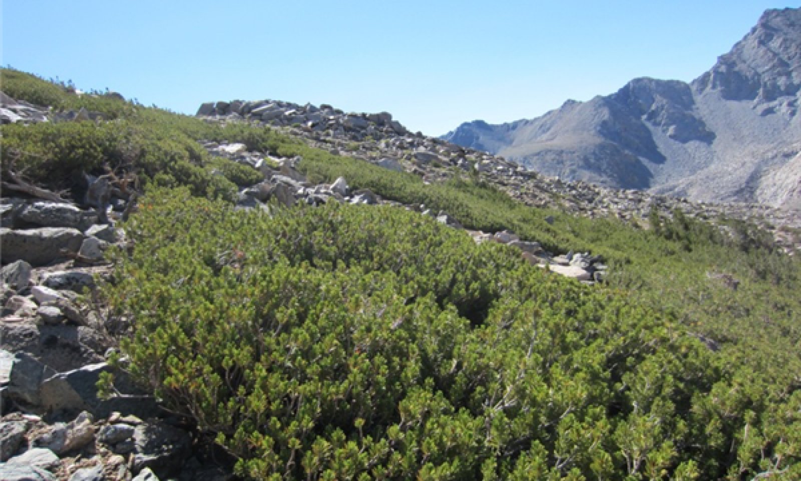
This ecological site occurs in the lowest elevations of the alpine LRU, at the alpine treeline ecotone, typically between 11,300 and 12,000 feet, on mountain slopes. Soils are derived from granitic parent material, and are very deep, with a sandy skeletal particle size class. Patches of krummholz whitebark pine (Pinus albicaulis) dominate. Wind exposure, cold temperatures, and a short growing season limit the growth of whitebark pine to a krummholz growth form. Coarse soils with very low water holding capacity support a minimal but unique component of dwarf alpine plants.
Similar sites
R022AA200CA Alpine Scree
This krummholz whitebark pine ecological site occurs in the northern Sierra Nevada on shallow soils over decomposed granite.
Table 1. Dominant plant species
Tree Not specified
Shrub (1) Pinus albicaulis
(2) Ericameria discoideaHerbaceous (1) Elymus elymoides
(2) Linanthus pungensPhysiographic features
This site is found on mountain slopes with elevation ranging from ---- and ---- feet, but the best representation of this site occurs between 11,300 and 12,000 feet. This site is found on all aspects. Slopes range from -- to -- percent, but are typically between 25 and 65 percent.
Table 2. Representative physiographic features
Landforms (1) Mountain slope
Flooding frequency None Ponding frequency None Aspect Aspect is not a significant factor Climatic features
The climate of this ecological site is characterized by cool temperatures, wet winters with most precipitation falling as snow in winters, and relatively dry summers. The mean annual precipitation ranges from -- to -- inches. The mean annual temperature ranges from -- to -- degrees F. The frost-free (>32F) season is -- to -- days. The freeze-free (>28F) season is ?? to ?? days.
Table 3 Representative climatic features
Frost-free period (average) 0 days Freeze-free period (average) 0 days Precipitation total (average) 0 in BarLineFigure 1. Monthly precipitation range
BarLineFigure 2. Monthly average minimum and maximum temperature
Figure 3. Annual precipitation pattern
Figure 4 Annual average temperature pattern
">Influencing water features
This site is not influenced by water features.
Soil features
The soils associated with this ecological site are very deep, and formed in colluvium and residuum derived from granitic rock. They are ---- drained with --- permeability. The soil moisture regime is xeric and the soil temperature regime is cryic. Surface rock fragments smaller than 3 mm in diameter average -- percent cover, and larger fragments average -- percent. Surface texture is----. Subsurface textures are ---. Subsurface rock fragments smaller than 3 mm in diameter average -- percent by volume, and larger fragments average -- percent (for a depth of ---). The Dusy soils are correlated to this ecological site. They are (TAX-Sandy Skeletal Typic Cryorthents).
This ecological site has been correlated to the following mapunits and soil components:
UPDATETable 4. Representative soil features
Parent material (1) Colluvium – granite
Soil depth 60 – 0 in Ecological dynamics
Abiotic Factors:
This ecological site occurs at the alpine treeline ecotone, typically between 11,300 and 12,000 feet, on mountain slopes. Wind exposure, cold temperatures, and a short -- to -- day growing season, limit the growth of whitebark pine to a shrubby krummholz stature. The whitebark pine krummholz canopy is typically less than less than 6 feet in tall. The soils associated with this ecological site are ---
Ecology-Disturbance Factors:
The formation of krummholz whitebark pine is driven by minimum temperatures and by wind and ice pruning of branches exposed above the snow pack. Krummholz trees may be greater than 1,500 years old (Miller 2014), but are typically less than 800 years, and continuously develop seedlings from seed caches. They may attain these older ages by layering of branches, which allows for new stem growth while older branches die back. The caching of whitebark pine seeds by Clark’s nutcracker (Nucifraga columbiana) is the primary mode of seed dispersal. The birds often cache seeds in open areas that are suitable for young seedlings. If all seeds are not consumed, they give rise to dense clusters of genetically similar whitebark pine. These clusters appear to be one tree with many stems, but are more often individual trees (Burns et al. 1990, Tomback et al. 2001a). Whitebark pine has ongoing recruitment from Clark’s nutcracker caches in the absence of disturbance, resulting in an increase in stand density over time.
Fire and avalanche are the primary natural drivers for succession in this ecological site, which is relatively stable. Fire ignition is frequent on these exposed ridges and mountain peaks, but there is minimal and discontinuous fuel to carry large or hot fires. Small fires may play a minor role in maintaining openings that favor the germination and survival of young whitebark pine seedlings (Burns et al. 1990, Tomback et al. 2001b, Howard 2002).
Avalanche is common among the alpine peaks and ridges, and can remove swaths of whitebark pine in avalanche prone chutes or below wind formed cornices. Areas prone to frequent avalanche are not stable long enough to support whitebark pine, but areas prone to less frequent avalanches or rare large avalanches will develop whitebark pine over time.
Whitebark pine is threatened by the non-native white pine blister rust (Cronartium ribicola), and the native mountain pine beetle (Dendroctonus ponderosae) (Cox 2000, Tomback et al. 2001b, Howard 2002). Severe epidemics have killed large areas of forest in the Rocky Mountains, but epidemics have not been as severe or as extensive in the Sierra Nevada. The non-native white pine blister rust (WPBR) was introduced into North America near Vancouver, British Columbia around 1910, and has been slowly spreading across the western United States and Canada. It was first detected in the Sierra Nevada Mountains in 1960’s. White pine blister rust is present in the northern Sierra Nevada and has been found at a few locations in the central Sierra Nevada, including Yosemite National Park and at a high Sierra location on the western slopes of the Sierra National Forest (Maloney 2011). It has not been detected on whitebark pine in the most southern Sierra Nevada including Sequoia and Kings Canyon National Park.
White pine blister rust could potentially infect whitebark pine in the southern Sierra, but synchronous phenological and environmental factors need to occur for WPBR to infect whitebark pine. Within the dry and high southern Sierra Nevada, this may be less common than at lower elevations and more northern latitudes (Maloney 2011). For infection to occur in five-needled white pines, relative humidity has to be greater than 90 percent, temperatures have to be between 35.6 and 64.4 °F (2 to 18 °C), and stomates need to be open to allow the WPBR entry (Maloney 2011). The basidiospores, which infect whitebark pine, are released in fall from the alternate hosts gooseberry or currents (Ribes sp.), or less commonly, lousewort or Indian paintbrush (Pedicularis or Castilleja sp.). These spores do not travel far or last long in the environment. Whitebark pine may have early onset winter dormancy, and the stomates may be typically be closed at the time WPBR basidiospores are released (Maloney 2011). The onset of winter dormancy for whitebark pine is dependent upon the length of growing season, precipitation and soil water holding capacity. This ecological site occurs on coarse textured soils often on steep south facing aspects. The snow melts earlier on south facing slopes, and water drains quickly out of the root zone, so the trees on this site may go into winter dormancy even earlier than whitebark pine growing on finer textures soils, on cooler aspects, or in more northern latitudes.
White pine blister rust affects the crown and cone producing limbs of mature trees, reducing cone production, and can kill younger trees within a year. The decrease in cone production, and high mortality of young trees threatens the regenerative success of this species (Maloney et al. 2012). A few studies have been conducted on genetic resistance, and results vary from no resistance (Maloney, personal communication), and 26 to 47 percent resistance in the Rocky Mountains and the Pacific Northwest (Keane et al. 2012).
A state altered by WPBR has been included in this state-and-transition model because of the documented incidences of WPBR in the central Sierra Nevada, and the slight potential that it may infect the southern Sierra Nevada. In other regions of whitebark pine forest, there is a potential to transition to a third state, where WPBR has cause a decline in cone production of less than 1000 cones/ Ha and basal area is < .5 m2/ acre. Below this threshold there may be insufficient seeds for Clark’s nutcracker and the regeneration of whitebark pine (McKinney et al. 2009).
Mountain pine beetles (MPB) preferentially attacks whitebark pine trees that are heavily infected with WPBR. They also appear to prefer whitebark pine over lodgepole pine, and trees with diameters over 6” dbh. Mountain pine beetles targets larger diameter trees at lower elevations but WPBR infected trees at all elevations and ages (Cluck 2014).
Reduced seed production affects the presence and abundance of Clark’s nutcracker, and in turn the number and distribution of seed caches (Tomback and Resler 2007, Keane et al. 2012). This can lead to recruitment below the threshold required to sustain populations (McKinney et al. 2009).
Predictions about climate change due to global warming suggest that the whitebark pine communities in the Sierra Nevada Mountains may be threatened by rising temperatures and precipitation changes, primarily due to secondary impacts as pathogens and lower elevation conifer species extend their ranges to higher elevations. Recent California based climate models predict a 9 °F (5 °C) increase in temperature by 2100, and Hayhoe et al. (2004) predict a 2 to 4 °F increase in winter and 4 to 8 °F increase in summer (Safford et al. 2012). Models are more variable for precipitation, but recent models for the Sierra Nevada, predict similar to slightly less precipitation. Most models agree that summers will become drier, since more of the precipitation is predicted to come as rain, and snow melt-off will occur earlier in spring (Hayhoe et al. 2004, Safford et al. 2012). This ecological site was experiencing a severe drought at the time of data collection and development (2012-2015), with 10 to 30 percent of average precipitation and very little snow accumulation in this region of the Sierra Nevada. Whether this is climate driven, and thus will become more of the future normal remains to be seen.
The alpine zone is defined as having mean annual summer temperatures of less than 43.5 °F or (6.4 °C), and a growing season of less than 94 days (Korner et al. 2011). The warming temperatures will affect the structure and distribution of the alpine ecotone. High elevation areas with suitable soils and landforms for the upward migration of whitebark pine will be important for the sustainability of this community. The long lived whitebark pine will most likely persist through the initial shift in climate, but the slow regeneration of this species in the limited expanses of suitable higher elevation habitat may be slow. The intermediate effect of warming temperatures may allow for more upright tree growth of whitebark pine and increased leader growth on compact krummholz forms. Indeed, upright tree growth forms have already significantly increased in alpine krummholz whitebark pine communities (Millar et al. 2004). However, a decrease in snow pack or earlier melt off may cause dieback of leaders and exposed krummholz, creating a more compact or less extensive krummholz community.
The dwarf alpine herbaceous community may also be impacted by warming temperatures. These small forbs and grasses lie close to the surface to obtain the maximum heat possible at this elevation. They live in a much warmer microclimate than trees, with their limbs exposed to air currents. A few degrees of warming may make the temperatures too extreme for these alpine species, since they have limited land at higher elevations for upward migration, and may have specific habitat requirements. A modeling analysis of warming temperature on the distribution of alpine forbs in the White Mountains California predicts local extinction of fewseed draba (Draba oligosperma) and ledge stonecrop (Rhodelia integrifolia) with a increase in mean annual air temperature of 5.4 °F (3 °C), with up to a 68 percent reduction in the other associated alpine species. Clubmoss mousetail (Ivesia lycopodioides), cushion draba (Draba breweri), Sierra lewisia (Lewisia glandulosa), and alpine lewisia (Lewisia pygmaea) were predicted to have a 98 percent decline in area with a 5.4 °F (3 °C) warming (Van de Ven et al. 2007). The species mentioned above were not documented on data collection sites, but have been documented in the vicinity of this ecological site by Calflora (Calflora 2014).
Warmer temperatures have shifted the thermal zone for mountain pine beetles upslope, subjecting higher elevations of whitebark pine to beetle attacks (Craig 2010, Keane et al. 2012, Keane and al 2013). Growth rates of whitebark pine stems has nearly doubled since 1880, due to warmer temperatures (Millar et al. 2004). The new leaders may obtain sufficient size (greater than 6 inch dbh), to be targeted by mountain pine beetles.
The historic temperature range for this ecological site is between 20 to 35 °F. With a 2 to 6 °F increase in mean annual temperature, species such as Sierra lodgepole pine (Pinus contorta var. murrayana) may move into this zone. A 9 °F increase over the next 85 years could make conditions favorable for upper montane species to establish. Species such as Jeffrey pine (Pinus jeffreyi) and California red fir (Abies magnifica) could survive with the longer growing season and warmer temperatures for seedling germination and leader growth. If lower elevation conifers establish in the whitebark pine zone, whitebark pine may become a seral species, dependent upon fire for continued regeneration and elimination of competitors.
In the state-and-transition model below, the reference community within the reference state consists of the most successionally advanced community phase (numbered 1.1) as well as other community phases that result from natural and human disturbances. Community phase 1.1 is deemed the phase representative of the most successionally advanced pre-European plant/animal community including periodic natural surface fires that influenced its composition and production. This phase is determined from the oldest modern day remnant forests and/or historic literature.
The potential for crossing the threshold for State 2 is low to very low, but this ecological site may extend into the central Sierra Nevada where whitebark pine bister rust has been documented, and therefore may potentially affect this ecosystem. Potential shifts due to warming temperatures are not included in this state-and-transition model.
All tabular data listed for a specific community phase within this ecological site description represent a summary of one or more field data collection plots taken in communities within the community phase. Although such data are valuable in understanding the phase (kinds and amounts of ground and surface materials, canopy characteristics, community phase overstory and understory species, production and composition, and growth), it typically does not represent the absolute range of characteristics nor an exhaustive listing of species for all the dynamic communities within each specific community phase.State and transition model
Custom diagramStandard diagram
Figure 5. R022AA101CA STM
More interactive model formats are also available. View Interactive Models
More interactive model formats are also available. View Interactive Models
Click on state and transition labels to scroll to the respective textEcosystem states
State 1 submodel, plant communities
State 2 submodel, plant communities
State 1
Reference StateThis state represents the reference conditions for this ecological site.
Community 1.1
Krummholz whitebark pine
Figure 6. Krummholz Whitebark Pine
The formation of krummholz whitebark pine is driven by low minimum temperatures and by wind and ice pruning of branches exposed above the snow pack. Krummholz whitebark pine typically has 25 to 45 percent cover across the slope, but within patches, cover is typically 60 to 65 percent. Canopy height can range from 4 to 13 feet, increasing at lower elevations and in more sheltered areas. Although relatively uniform in appearance, there is variation in age due to past disturbances, micro-features that allow for more rapid growth, and constant but slow regeneration. Krummholz trees may be greater than 1,500 years old (Millar 2014), but are typically less than 800 years, and continuously develop seedlings from seed caches. Regeneration can occur within the stand, which increases basal area and canopy cover.
The herbaceous community is sparse, with 1 to 10 percent total cover. Cover, diversity and production is higher in open areas, and nearly absent under the whitebark pine canopy. The forbs and grasses are barely noticeable from a distance, since they are so low growing and compact. Common species include rosy pussytoes (Antennaria rosea), rockcress (Arabis sp.), frosted buckwheat (Eriogonum incanum), cushion buckwheat (Eriogonum ovalifolium), pygmy fleabane (Erigeron pygmaeus), rosy buckwheat (Eriogonum rosense), Pacific hulsea (Hulsea algida), granite prickly phlox (Linanthus pungens), sedge (Carex sp.), Ross' sedge (Carex rossii), squirreltail (Elymus elymoides), Parry's rush (Juncus parryi), and spike trisetum (Trisetum spicatum). There may be 0 to 1 percent cover of shrubs including whitestem goldenbush (Ericameria discoidea), and wax currant (Ribes cereum).Figure 7. Annual production by plant type (representative values) or group (midpoint values)
Table 5. Annual production by plant type
Plant type Low
(lb/acre)Representative value
(lb/acre)High
(lb/acre)Tree 110 240 492 Forb 0 2 10 Grass/Grasslike 0 5 9 Shrub/Vine 0 1 3 Total 110 248 514 Table 6. Ground cover
Tree foliar cover 0-10% Shrub/vine/liana foliar cover 0% Grass/grasslike foliar cover 0-0% Forb foliar cover 0-0% Non-vascular plants 0% Biological crusts 0% Litter 10-20% Surface fragments >0.25" and <=3" 10-20% Surface fragments >3" 30-50% Bedrock 0-0% Water 0% Bare ground 0-0% Table 7. Soil surface cover
Tree basal cover 20-70% Shrub/vine/liana basal cover 0% Grass/grasslike basal cover 0-0% Forb basal cover 0-0% Non-vascular plants 0% Biological crusts 0% Litter 30-40% Surface fragments >0.25" and <=3" 10-20% Surface fragments >3" 30-60% Bedrock 0-0% Water 0% Bare ground 0-10% Table 8. Woody ground cover
Downed wood, fine-small (<0.40" diameter; 1-hour fuels) 1-3% Downed wood, fine-medium (0.40-0.99" diameter; 10-hour fuels) 0-1% Downed wood, fine-large (1.00-2.99" diameter; 100-hour fuels) 0-4% Downed wood, coarse-small (3.00-8.99" diameter; 1,000-hour fuels) – Downed wood, coarse-large (>9.00" diameter; 10,000-hour fuels) – Tree snags** (hard***) – Tree snags** (soft***) – Tree snag count** (hard***) Tree snag count** (hard***) * Decomposition Classes: N - no or little integration with the soil surface; I - partial to nearly full integration with the soil surface.
** >10.16cm diameter at 1.3716m above ground and >1.8288m height--if less diameter OR height use applicable down wood type; for pinyon and juniper, use 0.3048m above ground.
*** Hard - tree is dead with most or all of bark intact; Soft - most of bark has sloughed off.
Table 9. Canopy structure (% cover)
Height Above Ground (ft) Tree Shrub/Vine Grass/
GrasslikeForb <0.5 – 0% 0-2% 0-5% >0.5 <= 1 0-5% – – – >1 <= 2 5-20% – – – >2 <= 4.5 5-20% – – – >4.5 <= 13 0-1% – – – >13 <= 40 – – – – >40 <= 80 – – – – >80 <= 120 – – – – >120 – – – – Community 1.2
RegenerationFire, avalanche, or localized mortality from pathogens or insects create canopy gaps for whitebark pine regeneration from seed caches. Fire frequency studies are lacking for the krummholz whitebark community in the Sierra Nevada. The mean fire return intervals for whitebark pine forest across the US range from 29 to 300 years, while moderate severity fires range from 25 to 75 years, and stand replacing fires have greater than 140 year return interval (Fryer 2002). Lightning is the main ignition source, and fires are typically small spot fires.
Avalanches are common in this area, with varying frequency, size and velocities. Some avalanche chutes may have yearly or decadal avalanches in relatively confined chutes. These zones may never develop mature whitebark pine. Larger, less frequent avalanches can uproot and cause stem breakage in the avalanche path.
Whitebark pine is dependent upon Clark’s nutcracker for seed dispersal. Clark’s nutcracker prefers to cache seeds in open or disturbed areas, and those that are not recovered germinate and create young tree clusters. Seed predation in normal years may be up to 97 percent, leaving few seeds for germination. Germination and seedling establishment after fire may take several years because of the high predation rate, and short dormancy period in some seeds. Years with higher summer precipitation may have higher cone yields. The cones take two years to develop. After favorable cone production cycles, there will be more seeds left by predators for germination (Fryer 2002). Whitebark pine establishment may take longer than after fire, depending upon the degree of soil and seed cache disturbance. Seeds may need to come from new seed caches.
Growth of young seedlings is slow. In a typical stand, whitebark pine reaches cone maturity at 60 to 100 years (Fryer 2002), but the krummholz whitebark pine may take longer since it is in the coldest region of the whitebark pine zone.
The existing herbaceous community may be unaffected by fire due to its low lying nature and distance the whitebark pine canopy, however these forbs and shrubs may increase due to the decrease in canopy cover. Species may include rosy pussytoes, rockcress, frosted buckwheat, cushion buckwheat, pygmy fleabane, rosy buckwheat, Pacific hulsea, granite prickly phlox, sedge, Ross' sedge, squirreltail, Parry's rush, and spike trisetum, whitestem goldenbush, and wax currant.Community 1.3
Warm dry periods
Figure 8. 1.3
This community develops with the vertical release of whitebark pine leaders during a slightly warmer and drier climatic period and a negative Pacific Decadal Oscillation (PDO). Past episodes have occurred between 1945 and 1976 (Millar et al. 2004). This period of favorable growth enabled thick bark development on the leaders, which allowed leaders to persist through subsequent colder periods. Favorable climate conditions in the future may allow for another pulse of leader development, or additional height increases on the existing leaders.
Canopy cover ranges from 20 to 65 percent. Production and cover of the understory increases as canopy cover decreases. Data for this phase is from a plot with an open canopy, with fewer stones and boulders on the surface, so production is at the higher end.
Data was collected for this phase under current climate conditions, but production of whitebark pine is likely higher during the climate conditions that allow this phase to develop.Figure 9. Annual production by plant type (representative values) or group (midpoint values)
Table 10. Annual production by plant type
Plant type Low
(lb/acre)Representative value
(lb/acre)High
(lb/acre)Tree 150 200 250 Grass/Grasslike 5 31 36 Forb 5 20 25 Total 160 251 311 Table 11. Ground cover
Tree foliar cover 0-0% Shrub/vine/liana foliar cover 0% Grass/grasslike foliar cover 0-0% Forb foliar cover 0-0% Non-vascular plants 0% Biological crusts 0% Litter 30-70% Surface fragments >0.25" and <=3" 0-10% Surface fragments >3" 50-60% Bedrock 0-0% Water 0% Bare ground 0-10% Table 12. Soil surface cover
Tree basal cover 20-70% Shrub/vine/liana basal cover 0% Grass/grasslike basal cover 0-10% Forb basal cover 0-0% Non-vascular plants 0% Biological crusts 0% Litter 20-50% Surface fragments >0.25" and <=3" 0-0% Surface fragments >3" 40-60% Bedrock 0-0% Water 0% Bare ground 0-10% Table 13. Woody ground cover
Downed wood, fine-small (<0.40" diameter; 1-hour fuels) 1-4% Downed wood, fine-medium (0.40-0.99" diameter; 10-hour fuels) 3-10% Downed wood, fine-large (1.00-2.99" diameter; 100-hour fuels) 1-5% Downed wood, coarse-small (3.00-8.99" diameter; 1,000-hour fuels) – Downed wood, coarse-large (>9.00" diameter; 10,000-hour fuels) – Tree snags** (hard***) – Tree snags** (soft***) – Tree snag count** (hard***) Tree snag count** (hard***) * Decomposition Classes: N - no or little integration with the soil surface; I - partial to nearly full integration with the soil surface.
** >10.16cm diameter at 1.3716m above ground and >1.8288m height--if less diameter OR height use applicable down wood type; for pinyon and juniper, use 0.3048m above ground.
*** Hard - tree is dead with most or all of bark intact; Soft - most of bark has sloughed off.
Table 14. Canopy structure (% cover)
Height Above Ground (ft) Tree Shrub/Vine Grass/
GrasslikeForb <0.5 – – 0-6% 0-1% >0.5 <= 1 – – 0-2% 0-1% >1 <= 2 – – – – >2 <= 4.5 0-5% – – – >4.5 <= 13 20-65% – – – >13 <= 40 0-1% – – – >40 <= 80 – – – – >80 <= 120 – – – – >120 – – – – Pathway 1.1a
Community 1.1 to 1.2Fire, avalanche, or pathogens create gaps in canopy.
Pathway 1.1b
Community 1.1 to 1.3
Krummholz whitebark pine
Warm dry periodsWarm, dry period allows for leader growth and whitebark pine expansion.
Pathway 1.2a
Community 1.2 to 1.1This pathway is followed with time, growth and continued regeneration of whitebark pine.
Pathway 1.3b
Community 1.3 to 1.1
Warm dry periods
Krummholz whitebark pineCold period with lack of snow cover causes die-back of exposed leaders and branches.
Pathway 1.3a
Community 1.3 to 1.2Disturbances such as small fires, avalanche, pathogens, or insects create openings for regeneration.
State 2
Altered State, White pine blister rustThis state has developed with the introduction of the non-native white pine blister rust.
Community 2.1
Krummholz whitebark pineThis community is similar to community 1.1, but the krummholz whitebark pine has low to moderate infection rates from white pine blister rust. There may be death of infected younger trees, and dieback of infected branches on larger trees. Canopy cover may decline if infection rates increase and symptoms become more severe.
Community 2.2
RegenerationRegeneration occurs in canopy gaps from seeds germinating in Clark's nutcracker caches. Overall regeneration is lower due to reduced cone production and a higher percentage of seed consumption by Clark’s nutcracker, and potential infestation and mortality of young seedlings from WPBR infection.
Species are similar to Community Phase 1.2.Community 2.3
Leader DevelopmentKrummholz whitebark pine develops leaders that extend vertically above the krummholz canopy height during warm and dry years. Taller tree forms begin to develop. Tree density and cover increases with infilling of whitebark pine. This phase is more vulnerable to mountain pine beetle outbreaks.
Species are similar to Community Phase 1.3.Pathway 2.1a
Community 2.1 to 2.2Fire, death from pathogens, insects and/or avalanches create canopy openings and niches for whitebark pine seed caches and regeneration.
Pathway 2.1b
Community 2.1 to 2.3Period of warmer dry weather and negative PDO.
Pathway 2.2a
Community 2.2 to 2.1This pathway is followed with time, and slow regeneration of uninfected seedlings.
Pathway 2.3b
Community 2.3 to 2.1Cold winter, low snow pack, dieback of leaders due to exposure.
Pathway 2.3a
Community 2.3 to 2.2Fire, death from pathogens, and/or avalanches create canopy openings and niches for whitebark pine seed caches and regeneration.
Transition 1a
State 1 to 2This transition is triggered by infection of whitebark pine by Cronartium ribicola, the cause of white pine blister rust (WPBR), within this ecological site. White pine blister rust affects the crown and cone producing limbs of mature trees, reducing cone production, and can kill younger trees within a year. The decrease in cone production and high mortality of young trees threatens the regenerative success of this species (Maloney et al. 2012). Repeat waves of infection by WPBR under favorable climatic conditions can worsen the situation. Reduced seed production affects the presence and abundance of Clark’s nutcracker, and thus the number and distribution of seed caches (Tomback and Resler 2007, Keane et al. 2012). This can lead to recruitment below the threshold required to sustain populations (McKinney et al. 2009).
Restoration pathway R2a
State 2 to 1Restoration practices that have been experimented with include spraying pesticides for mountain pine beetle, and planting of theoretically disease resistant whitebark pine.
Additional community tables
Table 15. Community 1.1 plant community composition
Group Common name Symbol Scientific name Annual production () Foliar cover (%) Forb1 Forbs 0–10 frosted buckwheat ERIN9 Eriogonum incanum 0–2 0–1 granite prickly phlox LIPU11 Linanthus pungens 0–2 0–1 cushion buckwheat EROV Eriogonum ovalifolium 0–1 0–1 pygmy fleabane ERPY Erigeron pygmaeus 0–1 0–1 rosy buckwheat ERRO Eriogonum rosense 0–1 0–1 Pacific hulsea HUAL Hulsea algida 0–1 0–1 rosy pussytoes ANRO2 Antennaria rosea 0–1 0–1 rockcress ARABI2 Arabis 0–1 0–1 Grass/Grasslike2 Grasses and Grasslike 0–9 sedge CAREX Carex 0–2 0–1 Ross' sedge CARO5 Carex rossii 0–2 0–1 squirreltail ELEL5 Elymus elymoides 0–2 0–1 Parry's rush JUPA Juncus parryi 0–2 0–1 spike trisetum TRSP2 Trisetum spicatum 0–1 0–1 Shrub/Vine3 Shrubs 0–3 wax currant RICE Ribes cereum 0–2 0–1 whitestem goldenbush ERDI14 Ericameria discoidea 0–1 0–1 Tree4 Trees 110–492 whitebark pine PIAL Pinus albicaulis 110–492 55–65 Table 16. Community 1.2 plant community composition
Group Common name Symbol Scientific name Annual production () Foliar cover (%) Table 17. Community 1.3 plant community composition
Group Common name Symbol Scientific name Annual production () Foliar cover (%) Forb1 Forbs 5–25 rosy buckwheat ERRO Eriogonum rosense 0–12 0–1 Nuttall's sandwort MINU4 Minuartia nuttallii 0–4 0–1 Rydberg's penstemon PERY Penstemon rydbergii 0–4 0–1 rockcress ARABI2 Arabis 0–2 0–1 frosted buckwheat ERIN9 Eriogonum incanum 0–1 0–1 Grass/Grasslike2 Grasses and Grasslike 5–36 Ross' sedge CARO5 Carex rossii 0–28 0–4 needlegrass ACHNA Achnatherum 0–3 0–2 squirreltail ELEL5 Elymus elymoides 0–2 0–1 Parry's rush JUPA Juncus parryi 0–2 0–1 spike trisetum TRSP2 Trisetum spicatum 0–1 0–1 Tree3 Tree 150–250 whitebark pine PIAL Pinus albicaulis 150–250 20–65 Table 18. Community 2.1 plant community composition
Group Common name Symbol Scientific name Annual production () Foliar cover (%) Table 19. Community 2.2 plant community composition
Group Common name Symbol Scientific name Annual production () Foliar cover (%) Table 20. Community 2.3 plant community composition
Group Common name Symbol Scientific name Annual production () Foliar cover (%) Interpretations
Animal community
Clark’s Nutcracker and squirrels play a major role in seed dispersal for whitebark pine, by caching seeds. Bears have been reported to raid squirrel middens for the whitebark seeds (Howard 2002). Whitebark seeds provide valuable nutrition, and are an important food for bears, birds, and rodents. The trees also provide cover for and nesting cavities for birds and other wildlife.
Recreational uses
Backpacking, hiking, mountaineering are the main recreational activities in this area. Due to the highly erodible sandy soils, and steep slopes, trails should be constructed carefully.
Wood products
This has very low productivity and is not suited for timber or firewood production.
Other products
Krummholz whitebark pine has very low productivity and is not suited for timber or firewood production.
Supporting information
Inventory data references
The following NRCS plots were used to describe this ecological site: 1.1 2012CA7921063- Type location 2013CA7921055 2014CA7921036 1.3 2013CA7937503
Type locality
Location 1: Fresno County, CA UTM zone N UTM northing 4107736 UTM easting 360770 General legal description The Type location is on a steep south facing mountain slope, approximately 2 miles west of Dusy Basin in Sequoia and Kings Canyon National Park. Other references
Burns, R. M., B. H. Honkala, and United States. Forest Service. 1990. Silvics of North America. U.S. Dept. of Agriculture For sale by the Supt. of Docs., U.S. G.P.O., Washington.
Calflora, 2014. Information on California plants for education, research and conservation, with data contributed by public and private institutions and individuals, including the Consortium of California Herbaria. [web application]. 2014. Berkeley, California: The Calflora Database [a non-profit organization]. Available: http://www.calflora.org/ (Accessed: Dec 29, 2014).
Cluck, D. 2014. Mountain Pine Beetle Outbreak in the Warner Mountains: Implications for Whitebark Pine.in Northern California Botanist Special Workshop / Session, Chico, CA.
Cox, S. 2000. Management of Whitebark Pine (Pinus albicaulis) in North American Forest and National Parks. Colorado State University.
Craig, R. K. 2010. “Stationarity is dead”—long live transformation: five principles for climate change adaptation law. Harvard Environmental Law Review:66.
Fryer, J. L. 2002. Pinus albicaulis. . In: Fire Effects Information System, [Online]. U.S. Department of Agriculture, Forest Service, Rocky Mountain Research Station, Fire Sciences Laboratory
Hayhoe, K., D. Cayan, C. B. Field, P. C. Frumhoff, E. P. Mauren, N. L. Miller, S. C. Moser, S. H. Schneider, K. N. Cahill, E. E. Cleland, L. Dale, R. Drapek, R. M. Hanemann, L. S. Kalkstein, J. Lenihan, C. K. Lunch, R. P. Neilson, S. C. Sheridan, and J. H. Verville. 2004. Emissions pathways, climate change, and impacts on California. Proceedings of the National Academy of Sciences 101.
Howard, J. 2002. Pinus albicaulis. Fire Effects Information System. U.S. Department of Agriculture, Forest Service, Rocky Mountain Research Station, Fire Sciences Laboratory.
Keane et. al. 2013. Climate Change and Whitebark Pine: Compelling reasons for restoration. WPEF Climate Change White Paper.
Keane, R. E., D. F. Tomback, C. A. Aubry, A. D. Bower, E. M. Campbell, C. L. Cripps, M. B. Jenkins, M. F. Mahalovich, M. Manning, S. T. McKinney, M. P. Murray, D. L. Perkins, D. P. Reinhart, C. Ryan, A. W. Schoettle, and C. M. Smith. 2012. A Wide Range Restoration Strategy for Whitebark Pine (Pinus albicaulis). Page 108 GTR RMRS-GTR-279. US Department of Agriculture, Forest Service, Rocky Mountain Research Center, Fort Collins, CO.
Korner, C., J. Paulsen, and E. M. Spehn. 2011. A definition of mountains and their bioclimatic belts for global comparisons of biodiversity data. Alpine Botany.
Maloney, P. 2011. Incidence and distribution of white pine blister rust in the high elevation forests of California. Forest Pathology:8.
Maloney, P., D. R. Vogler, C. E. Jensen, and A. D. Mix. 2012. Ecology of whitebark pine populations in relation to white pine blister rust infection in subalpine forests of the Lake Tahoe Basin, USA: Implications for restoration. Forest Ecology and Management 280:166-175.
McKinney, S. T., C. E. Fiedler, and D. F. Tomback. 2009. Invasive pathogen threatens bird–pine mutualism: implications for sustaining a high-elevation ecosystem. Ecological Applications 19:10.
Millar, C. I. 2014. Climate, Bark Beetles, and High Elevation Pines (Whitebark and Limber) in the Great Basin: Not Always a Bad Combination. .in Northern California Botanist Special Workshop / Session, Chico, CA.
Millar, C. I., R. D. Westfall, D. L. Delaney, J. C. King, and L. J. Graumlich. 2004. Response of subalpine conifers in the Sierra Nevada, California, USA, to 20th-century warming and decadal climate variability. Arctic, Antarctic, and Alpine Research 36:181-200.
Safford, H. D., M. North, and M. D. Meyer. 2012. Climate change and the relevance of historical forest conditions. Page 22 in M. North, editor. Managing Sierra Nevada Forest. United States Department of Agriculture.
Tomback, D. F., S. F. Arno, and R. E. Keane. 2001b. Whitebark Pine Communities: Ecology & Restoration. Island Press, Washington D.C.
Tomback, D. F., and L. M. Resler. 2007. Invasive pathogens at alpine treeline: consequences for treeline dynamics. Physical Geography 28:397-418.
Van de Ven, C. M., S. B. Weiss, and W. G. Ernst. 2007. Plant Species Distributions under Present Conditions and Forecasted for Warmer Climates in an Arid Mountain Range. Earth Interactions 11:33.
Contributors
Marchel Munnecke
Rangeland health reference sheet
Interpreting Indicators of Rangeland Health is a qualitative assessment protocol used to determine ecosystem condition based on benchmark characteristics described in the Reference Sheet. A suite of 17 (or more) indicators are typically considered in an assessment. The ecological site(s) representative of an assessment location must be known prior to applying the protocol and must be verified based on soils and climate. Current plant community cannot be used to identify the ecological site.
Author(s)/participant(s) Contact for lead author Date Approved by Approval date Composition (Indicators 10 and 12) based on Annual Production Indicators
-
Number and extent of rills:
-
Presence of water flow patterns:
-
Number and height of erosional pedestals or terracettes:
-
Bare ground from Ecological Site Description or other studies (rock, litter, lichen, moss, plant canopy are not bare ground):
-
Number of gullies and erosion associated with gullies:
-
Extent of wind scoured, blowouts and/or depositional areas:
-
Amount of litter movement (describe size and distance expected to travel):
-
Soil surface (top few mm) resistance to erosion (stability values are averages - most sites will show a range of values):
-
Soil surface structure and SOM content (include type of structure and A-horizon color and thickness):
-
Effect of community phase composition (relative proportion of different functional groups) and spatial distribution on infiltration and runoff:
-
Presence and thickness of compaction layer (usually none; describe soil profile features which may be mistaken for compaction on this site):
-
Functional/Structural Groups (list in order of descending dominance by above-ground annual-production or live foliar cover using symbols: >>, >, = to indicate much greater than, greater than, and equal to):
Dominant:
Sub-dominant:
Other:
Additional:
-
Amount of plant mortality and decadence (include which functional groups are expected to show mortality or decadence):
-
Average percent litter cover (%) and depth ( in):
-
Expected annual annual-production (this is TOTAL above-ground annual-production, not just forage annual-production):
-
Potential invasive (including noxious) species (native and non-native). List species which BOTH characterize degraded states and have the potential to become a dominant or co-dominant species on the ecological site if their future establishment and growth is not actively controlled by management interventions. Species that become dominant for only one to several years (e.g., short-term response to drought or wildfire) are not invasive plants. Note that unlike other indicators, we are describing what is NOT expected in the reference state for the ecological site:
-
Perennial plant reproductive capability:
Print Options
Sections
Font
AAAAOther
PrintThe Ecosystem Dynamics Interpretive Tool is an information system framework developed by the USDA-ARS Jornada Experimental Range, USDA Natural Resources Conservation Service, and New Mexico State University.
Accessibility statement


