
Natural Resources
Conservation Service
-
Search


Major Land Resource Area or ecological site by name and/or ID.
PreviousSectionsNextGeneral information
Approved. An approved ecological site description has undergone quality control and quality assurance review. It contains a working state and transition model, enough information to identify the ecological site, and full documentation for all ecosystem states contained in the state and transition model.
Click to explore map
Figure 1. Mapped extent
Areas shown in blue indicate the maximum mapped extent of this ecological site. Other ecological sites likely occur within the highlighted areas. It is also possible for this ecological site to occur outside of highlighted areas if detailed soil survey has not been completed or recently updated.
MLRA notes
Major Land Resource Area (MLRA): 022A–Sierra Nevada and Tehachapi Mountains
MLRA 22A
Major Land Resource Area 22A, Sierra Nevada Mountains, is located predominantly in California and a small section of western Nevada. The area lies completely within the Sierra Nevada Section of the Cascade-Sierra Mountains Province. The Sierra Nevada range has a gentle western slope, and a very abrupt eastern slope. The Sierra Nevada consists of hilly to steep mountains and occasional flatter mountain valleys. Elevation ranges between 1,500 and 9,000 ft throughout most of the range, but peaks often exceed 12,000 ft. The highest point in the continental US occurs in this MLRA (Mount Whitney, 14,494 ft). Most of the Sierra Nevada is dominated by granitic rock of the Mesozoic age, known as the Sierra Nevada Batholith. The northern half is flanked on the west by a metamorphic belt, which consists of highly metamorphosed sedimentary and volcanic rocks. Additionally, glacial activity of the Pleistocene has played a major role in shaping Sierra Nevada features, including cirques, arêtes, and glacial deposits and moraines. Average annual precipitation ranges from 20 to 80 inches in most of the area, with increases along elevational and south-north gradients. Soil temperature regime ranges from mesic, frigid, and cryic. Due to the extreme elevational range found within this MLRA, Land Resource Units (LRUs) were designated to group the MLRA into similar land units.
LRU "C" Northern Sierra Subalpine: Elevations are typically between 7,800 and 9,800 feet. The frost free period is between 30 and 90 days, MAAT is between 35 and 44 degrees, MAP is between 45 and 65 inches. Soils are typically cryic, but frigid soils may occur at lower elevations on southern aspects. Forests are dominated by whitebark pine (Pinus albicaulis), Sierra lodgepole pine (Pinus contorta spp. murrayana), mountain hemlock (Tsuga mertensiana) and/or California red fir (Abies magnifica).Classification relationships
Forest Alliance = Pinus albicaulis – Whitebark pine forest; Association = tentatively Pinus albicaulis/Achnatherum californica (Sawyer, John O., Keeler-Wolf, Todd, and Evens, Julie M. 2009. A Manual of California Vegetation. 2nd ed. California Native Plant Society Press. Sacramento, California.)
Ecological site concept
This ecological site occurs in the highest elevations of the northern subalpine LRU, typically between 9,000 and 10,500 feet on mountain slopes that are typically between 15 and 50 percent. Soils are derived from granitic parent material, and are shallow to moderately deep over paralithic granitic bedrock, with a sandy skeletal particle size class. This site is dominated by whitebark pine (Pinus albicaulis) forest. Cold temperatures and a short growing season restrict the occurrence of less frost resistant conifers. Coarse soils with very low water holding capacity support a minimal understory.
Associated sites
F022AC002CA Cryic Sandy North Apsect Mountain Slopes
This ecological site occurs on north aspects and is a mountain hemlock (Tsuga mertensiana) - whitebark pine forest.
F022AC003CA Frigid-Cryic Sandy Slopes
This ecological site occurs at lower elevations and is dominated by California red fir (Abies magnifica)- western white pine (Pinus monticola) forests.
F022AC005CA Cryic Sheltered, Moist Sandy Mountain Slopes
This ecological site occurs on northern aspects on granitic soils. A mixed subalpine forest is present, dominated by mountain hemlock and Sierra lodgepole pine.
F022AC007CA North-Facing Cryic Loamy Mountain Slopes
This ecological site occurs volcanic soils on north facing aspects. A mixed subalpine forest is present composed of mountain hemlock, western white pine, lodgepole pine (Pinus contorta var. murrayana), and California red fir.
F022AF004CA Frigid, Shallow To Deep, Sandy Mountain Slopes
This ecological site occurs on shallow to moderately deep, frigid soils, on southern aspects, with an open Jeffrey pine forest, and montane shrubs.
F022AX101CA Moist Colluvial Headwater System
This ecological site occurs in headwater swales, with quaking aspen (Populus tremuloides) forests dominant.
R022AA200CA Alpine Scree
This ecological site occurs in the alpine LRU, on mountain peaks and ridges, an alpine forb community is dominant.
R022AC204CA Cryic, Umbric Or Andic Slopes
This ecological site occurs on soils with an umbric horizon or volcanic parent material. Mountain sagebrush (Artemisia tridentata spp. vaseyana) and antelope bitterbrush (Purshia tridentat) are dominant.
R022AE202CA Granitic Pocket
This ecological site occurs at the lower elevations on glacially scoured basins and sideslopes. Scattered western juniper (Juniperus grandis) and Sierra lodgepole pine are present, with forbs and grasses.
R022AE213CA Steep Rubbly Slope
This ecological site occurs at the lower elevations on south facing, frigid soils, with a high amount of rubble. Montane shrublands are present, dominated by greenleaf manzanita (Arctostaphylos patula) and whitethorn ceanothus (Ceanothus cordulatus).
Similar sites
R022AC200CA High Elevation Volcanic Mountain Slopes
This ecological site occurs on volcanic soils. Whitebark pine woodlands dominant with a more diverse understory.
F022AB112CA Gravelly Loamy Slopes
This ecological site occurs in the southern subalpine LRU, on moderately deep soils over hard granitic bedrock, and typically has finer surface textures. Whitebark pine woodlands are present.
F022AC002CA Cryic Sandy North Apsect Mountain Slopes
This ecological site occurs on northern aspects, and mountain hemlock is co-dominant.
Table 1. Dominant plant species
Tree (1) Pinus albicaulis
Shrub Not specified
Herbaceous (1) Arabis platysperma
(2) AchnatherumPhysiographic features
This site is on moderate to steeply sloping mountain sides at elevations ranging from 8,500 feet to 12,000 feet, although elevations are more typically between 9,000 and 10,500 feet. Slopes may range from 8 to 75 percent, but are typically between 15 and 50 percent. This site can be found on all aspects, but is generally orientated on northwest to south-facing slopes.
Table 2. Representative physiographic features
Landforms (1) Mountain slope
(2) Mountain
Flooding frequency None Ponding frequency None Elevation 8500 – 12000 ft Slope 8 – 75 % Aspect S, SW, NW Climatic features
The average annual precipitation ranges from 35 to 55 inches, and falls mostly in the form of snow from November to April. The mean annual air temperature ranges from 34 to 37 degrees Fahrenheit. The frost-free (>32F) season is 25 to 45 days, and the freeze-free (>28F) season is 35 to 60 days.
Maximum and minimum monthly climate data for this ESD were generated using PRISM data (PRISM Climate Group, Oregon State University, http://prism.oregonstate.edu, created 4 Feb 2004.) and the ArcGIS ESD extract tool.Table 3 Representative climatic features
Frost-free period (average) 30 days Freeze-free period (average) 50 days Precipitation total (average) 50 in BarLineFigure 2. Monthly precipitation range
BarLineFigure 3. Monthly average minimum and maximum temperature
Figure 4. Annual precipitation pattern
Figure 5 Annual average temperature pattern
">Influencing water features
This ecological site is not influenced by wetland or riparian water features.
Soil features
The soils associated with this ecological site are shallow to moderately deep, and formed in colluvium and residuum derived from granitic rock. They are somewhat excessively drained with rapid permeability. The soil moisture regime is xeric and the soil temperature regime is cryic. Surface rock fragments smaller than 3 inches in diameter range from 25 to 70 percent cover, and larger fragments range from 20 to 22 percent. Surface textures are very gravelly loamy coarse sand and very cobbly loamy coarse sand. Subsurface textures are very gravelly loamy coarse sand, very gravelly coarse sand, and extremely and very stony loamy coarse sand. Subsurface rock fragments smaller than 3 inches in diameter range from 24 to 32 percent by volume, and larger fragments range from 12 to 34 percent (for a depth of 0 to 40 inches). Decomposed granite (grus) bedrock occurs at 10 to 40 inches. The Jobsis and Whittell soils are correlated to this ecological site. The Jobsis soils are Sandy-skeletal, mixed, shallow, Typic Cryorthents, and the Whitell soils are Sandy-skeletal, mixed Typic Cryorthents.
This ecological site has been correlated with the following mapunits and soil components in the Tahoe Basin soil survey area (CA693):
Mapunit symbol; Mapunit name; Component; Phase; Percent
7500;Rock outcrop, granitic;Jobsis;;1
7511;Shalgran-Rock outcrop complex, 30 to 75 percent slopes;Jobsis;;2
9401;Dagget very gravelly loamy coarse sand, 15 to 30 percent slopes, extremely bouldery;Jobsis;;3
9402;Dagget very gravelly loamy coarse sand, 30 to 50 percent slopes, extremely bouldery;Jobsis;;3
9403;Dagget very gravelly loamy coarse sand, 50 to 70 percent slopes, extremely bouldery;Jobsis;;3
9404;Dagget very gravelly loamy coarse sand, moist, 5 to 15 percent slopes, rubbly;Jobsis;;2
9405;Dagget very gravelly loamy coarse sand, moist, 15 to 30 percent slopes, rubbly;Jobsis;;2
9406;Dagget very gravelly loamy coarse sand, moist, 30 to 70 percent slopes, rubbly;Jobsis;;2
9407;Dagget-Rock outcrop complex, moist, 30 to 70 percent slopes;Jobsis;;2
9421;Jobsis-Whittell-Rock outcrop complex, cool, 8 to 30 percent slopes;Jobsis;;45
9461;Whittell-Jobsis-Rock outcrop complex, cool, 30 to 75 percent slopes;Jobsis;;25
9421;Jobsis-Whittell-Rock outcrop complex, cool, 8 to 30 percent slopes;Typic Cryorthents;;4
9401;Dagget very gravelly loamy coarse sand, 15 to 30 percent slopes, extremely bouldery;Whittell;;3
9403;Dagget very gravelly loamy coarse sand, 50 to 70 percent slopes, extremely bouldery;Whittell;;3
9404;Dagget very gravelly loamy coarse sand, moist, 5 to 15 percent slopes, rubbly;Whittell;;2
9405;Dagget very gravelly loamy coarse sand, moist, 15 to 30 percent slopes, rubbly;Whittell;;2
9406;Dagget very gravelly loamy coarse sand, moist, 30 to 70 percent slopes, rubbly;Whittell;;2
9407;Dagget-Rock outcrop complex, moist, 30 to 70 percent slopes;Whittell;;4
9411;Freelpeak-Windyridge-Rock outcrop complex, 15 to 75 percent slopes;Whittell;;3
9421;Jobsis-Whittell-Rock outcrop complex, cool, 8 to 30 percent slopes;Whittell;;25
9461;Whittell-Jobsis-Rock outcrop complex, cool, 30 to 75 percent slopes;Whittell;;45
Table 4. Representative soil features
Parent material (1) Colluvium – granodiorite
Surface texture (1) Very cobbly loamy coarse sand
(2) Very stony coarse sand
Family particle size (1) Sandy
Drainage class Somewhat excessively drained Permeability class Very slow Soil depth 10 – 39 in Surface fragment cover <=3" 25 – 70 % Surface fragment cover >3" 20 – 22 % Available water capacity
(0-40in)0.77 – 1.07 in Soil reaction (1:1 water)
(0-40in)5.1 – 6.5 Subsurface fragment volume <=3"
(Depth not specified)24 – 32 % Subsurface fragment volume >3"
(Depth not specified)12 – 34 % Ecological dynamics
Abiotic Features:
This ecological site occurs in the highest elevations of the northern subalpine LRU, typically between 9,000 and 10,000 feet on mountain slopes. Soils are derived from granitic parent material, and are shallow to moderately deep over paralithic granitic bedrock, with a sandy skeletal particle size class. Cold temperatures and a short growing season restrict development of less frost resistant conifers. Coarse soils with very low water holding capacity support a minimal understory.
Ecology-Disturbance Factors:
Individual whitebark pine trees are very slow growing, and may be up to1500 years old (Millar 2014). Stands are composed of multiple age-class single and multiple stem trees because of ongoing seedling establishment. Caching of whitebark pine seeds by Clark’s nutcracker is the primary mode of seed dispersal, with birds often caching seeds in open areas that are suitable for young seedlings. If all seeds are not consumed, they give rise to dense clusters of genetically similar whitebark pine. These clusters appear to be one tree with many stems, but are more often individual trees (Burns et al. 1990, Tomback et al. 2001a). In the absence of disturbance, ongoing recruitment from seed-caches occurs, leading to an increase in stand density over time.
Fire and avalanche are the primary natural drivers for succession. Fire ignition is frequent on these exposed ridges and mountain peaks, but there is minimal and discontinuous fuel to carry large or hot fires. Small fires may play a minor role in maintaining openings that favor the germination and survival of young whitebark pine seedlings (Burns et al. 1990, Tomback et al. 2001b, Howard 2002). Avalanche is common among the alpine peaks and ridges, and can remove swaths of vegetation in avalanche prone chutes or below wind formed cornices.
Whitebark pine forests are threatened by the non-native Cronartium ribicola, the cause of white pine blister rust (WPBR) and the native mountain pine beetle (Dendroctonus ponderosae) (Cox 2000, Tomback et al. 2001b, Howard 2002). Severe epidemics of WPBR in combination with MPB outbreaks have killed large areas of forest in the Rocky Mountains, but the whitebark pine forests in the Sierra Nevada have not suffered as high mortality. There is a complex interaction between MPB outbreaks, WPBR infection, and climate. Mountain pine beetles prefer larger diameter trees (> 6 inch diameter at breast height), as these are necessary to complete their life cycle,, and attack at the warmer, lower elevation zone of whitebark pine. Mountain pine beetles preferentially attack trees infected by WPBR. White pine blister rust will infest all whitebark pines, regardless of age or elevation (Cluck 2014).
Mountain pine beetles are a native species in North American forests, but warmer temperatures have shifted the thermal zone for mountain pine beetles upslope, subjecting higher elevations of whitebark pine to beetle attacks (Craig 2010, Keane et al. 2012, Keane and al 2013). Severe mountain pine beetle epidemics cause high mortality of overstory trees, while suppressed understory trees may be released (Meyer and Safford 2014). A flush of regeneration may occur due to the reduction in the overstory canopy providing new areas for establishment. However, the decline in seed production due to the loss of large overstory trees will leave fewer seeds to be consumed by Clark’s nutcracker and other animals which leaves fewer seeds available for regeneration, threatening stand sustainability.
The non-native WPBR was introduced into North America near Vancouver, British Columbia in approximately 1910, and has been slowly spreading across the western United States and Canada. It currently occurs throughout the Cascades, and north and central Sierra Nevada. So far, it has not been detected on whitebark pine in the southern extent of the Sierra Nevada, but has been found on a whitebark pine in Yosemite National Park and in a high Sierra location on the western slope of the Sierra National Forest (Maloney 2011). A survey was conducted in 2009 to determine WPBR presence and effect on whitebark pine survivorship in the Lake Tahoe Basin. Mean incidence of WPBR among whitebark pine populations was 35 percent, with a range of 1 to 65 percent (Maloney et al. 2012).
In order for WPBR to infect whitebark pine several synchronous phenological and environmental factors need to occur. For infection to occur in five-needled white pines, relative humidity has to be greater than 90 percent, temperatures have to be between 35.6 and 64.4 degrees F (2 to 18 degrees C), and stomates need to be open to allow WPBR entry (Maloney 2011). The basidiospores, which infect whitebark pine, are released in fall from the alternate host currants (Ribes sp.), or less commonly, lousewort or Indian paintbrush (Pedicularis or Castilleja sp.). These spores do not travel far or last long in the environment, and years with late summer or early fall precipitation are most likely when infection will occur. Whitebark pine may have early onset winter dormancy, so stomates are closed at the time WPBR basidiospores are released (Maloney 2011). The onset of winter dormancy is dependent upon the length of the growing season (temperature), precipitation and soil available water capacity (AWC).
There appears to be a relationship between soils with higher AWC and higher infection rates or intensity of stem girdling (Maloney et al. 2012). Higher soil moisture could increase WPBR mycelium growth rates and increase basidiospore production, while also allowing for whitebark pine stomates to remain open longer in the season, increasing the probability of infection (Maloney et al. 2012). This ecological site occurs on shallow to moderately deep sandy-skeletal soils, with lower AWC than the corresponding volcanic ecological site (R022AC200CA), and is likely less susceptible to WPBR infestation. A 2009 inventory of WPBR showed that the whitebark stands occurring on granitic soils had infestation rates ranging from 1 to 19%, while stands on volcanic soils ranged from -- to 65% (Maloney et al. 2012).
The main impact of WPBR on whitebark pine is reduction in stand cone production due to die-back of cone bearing branches from cankers girdling the branches. Mortality rates in older trees are low, and may take decades to occur. Younger trees may be killed quickly if main stem girdling causes disruption of water flow (Maloney et al. 2012). A few studies have been conducted on genetic resistance to WPBR, and results range from no resistance (Maloney, personal communication), to 26 to 47 percent in the Rocky Mountains and the Pacific Northwest (Keane et al. 2012).
Reduced seed production affects the presence and abundance of Clark’s nutcracker, and thus the number and distribution of seed caches (Tomback and Resler 2007, Keane et al. 2012). This can lead to recruitment below the threshold required to sustain populations (McKinney et al. 2009).
Predictions about climate change suggest that the whitebark pine communities in the Sierra Nevada Mountains may be threatened by rising temperatures and precipitation changes. Recent California based climate models predict a 9 degree F increase in temperature by 2100, and broader models predict a 2 to 4 degree F increase in winter and 4 to 8 degree increase in summer (Safford et al. 2012). Models are more variable for precipitation, but local models for the Sierra Nevada, predict similar to slightly less precipitation. Most models agree that summers will become drier, since more of the precipitation is predicted to come as rain, and snow melt-off will occur earlier in spring (Hayhoe et al. 2004, Safford et al. 2012). Presently a severe drought is occurring in the Sierra Nevada, with 10 to 30 percent of average precipitation and very little snow accumulation. Whether this is climate driven, and thus will become more of the future normal remains to be seen.
High elevation areas with suitable soils and landforms for the upward migration of whitebark pine will be important for the sustainability of this community. However, in this region of the central Sierra Nevada, whitebark pine already occurs at the upper most elevations of the highest mountains in the area, so has little room to move upslope. The southern Sierra Nevada, with its higher mountain peaks, may prove to be an important refugium for this species.
The historic temperature range for this ecological site is between 34 to 37 degrees F. With a 2 to 6 degree warming, species such as Sierra lodgepole pine (Pinus contorta var. murrayana), or mountain hemlock (Tsuga mertensiana) may become dominant in this zone. A 9 degree warming shift over the next 85 years could make conditions favorable for upper montane species to establish. Species such as Jeffrey pine (Pinus jeffreyi) and California red fir (Abies magnifica) could survive with the longer growing season and warmer temperatures for seedling germination and leader growth. If lower elevation conifers establish in the whitebark pine zone, whitebark pine may become a seral species, dependent upon fire for continued regeneration and elimination of competitors.
The reference state consists of the most successionally advanced community phase (numbered 1.1) as well as other community phases that result from natural and human disturbances. Community phase 1.1 is deemed the phase representative of the most successionally advanced pre-European plant/animal community including periodic natural surface fires that influenced its composition and production. This phase is determined from the oldest modern day remnant forests and/or historic literature.
All tabular data listed for a specific community phase within this ecological site description represent a summary of one or more field data collection plots taken in communities within the community phase. Although such data are valuable in understanding the phase (kinds and amounts of ground and surface materials, canopy characteristics, community phase overstory and understory species, production and composition, and growth), it typically does not represent the absolute range of characteristics nor an exhaustive listing of species for all the dynamic communities within each specific community phase.State and transition model
Custom diagramStandard diagram
Figure 6. F022AC001CA STM
More interactive model formats are also available. View Interactive Models
More interactive model formats are also available. View Interactive Models
Click on state and transition labels to scroll to the respective textEcosystem states
State 1 submodel, plant communities
State 2 submodel, plant communities
State 3 submodel, plant communities
State 1
ReferenceThis state represents the reference conditions for this ecological site. A portion of this ecological site exists in this state in stands that do not show symptoms of WPBR.
Community 1.1
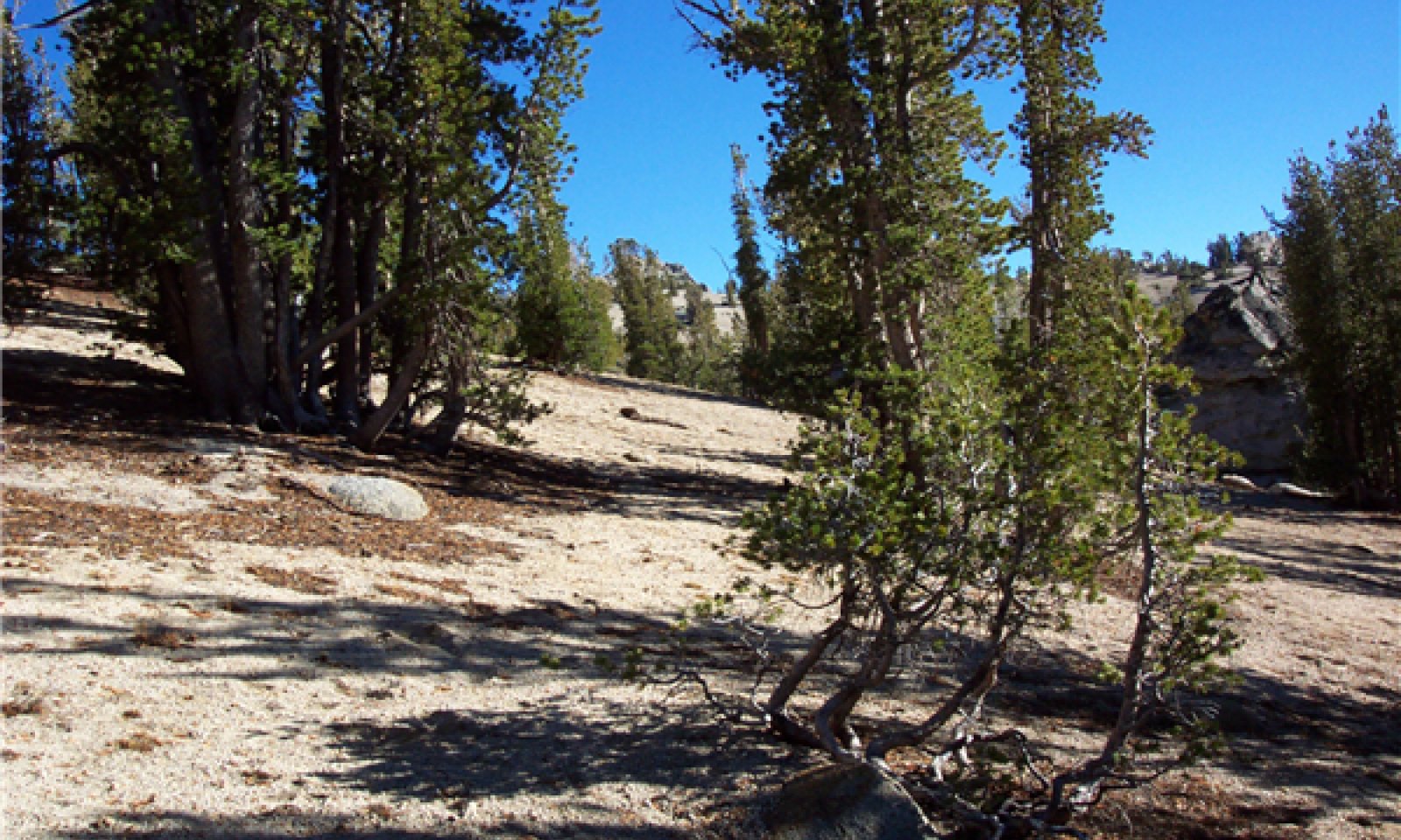
Whitebark pine forest
Figure 7. Whitebark pine forest
This phase is dominated by a canopy of multiple and single-stem whitebark pines, overstory cover ranging from 10 to 40 percent, and averaging 20 percent. Trees less than 13 feet in height range in cover from 1 to 5 percent. Overstory canopy height ranges from 15 to 30 feet with ages of 150 to 500 years old. Sierra lodgepole pine (Pinus contorta var. murrayana) and western white pine (Pinus monticola) may occur in limited amounts. Mountain hemlock (Tsuga mertensiana) may occur in limited amounts particularly on more northerly steep slopes. The understory is dominated by gravel and rock with a low cover of graminoid, herbaceous and subshrub species.
Forest understory. The understory is sparse, making up only one percent cover. Species composition is variable, but the more common species are Shasta knotweed (Polygonum shastensis), pioneer rockcress (Arabis platysperma), Davidson''s penstemon (Penstemon davidsonii), marumleaf buckwheat (Eriogonum marifolium), spreading phlox (Phlox diffusa) and needlegrass (Achnatherum spp.).
Table 5. Ground cover
Tree foliar cover 10-40% Shrub/vine/liana foliar cover 0-10% Grass/grasslike foliar cover 0% Forb foliar cover 0-10% Non-vascular plants 0-10% Biological crusts 0% Litter 0-20% Surface fragments >0.25" and <=3" 20-80% Surface fragments >3" 10-30% Bedrock 0-20% Water 0% Bare ground 10-20% Table 6. Soil surface cover
Tree basal cover 0-10% Shrub/vine/liana basal cover 0-0% Grass/grasslike basal cover 0-0% Forb basal cover 0-0% Non-vascular plants 0-10% Biological crusts 0% Litter 0-40% Surface fragments >0.25" and <=3" 20-80% Surface fragments >3" 10-30% Bedrock 0-20% Water 0% Bare ground 10-20% Table 7. Canopy structure (% cover)
Height Above Ground (ft) Tree Shrub/Vine Grass/
GrasslikeForb <0.5 0-1% 0-5% 0-1% 0-5% >0.5 <= 1 0-1% 0-5% – 0-5% >1 <= 2 0-1% – – – >2 <= 4.5 0-1% – – – >4.5 <= 13 0-5% – – – >13 <= 40 10-40% – – – >40 <= 80 – – – – >80 <= 120 – – – – >120 – – – – Community 1.2
Disturbance- regenerationFire, avalanche, or localized mortality from pathogens creates canopy gaps for whitebark pine regeneration from seed caches. Fire frequency studies are lacking for the whitebark communities in the Sierra Nevada. Mean fire return intervals for whitebark pine forest across the US range from 29 to 300 years, while moderate severity fires range from 25 to 75 years, and stand replacing fires have greater than 140 year return interval (Fryer 2002). Lightning is the main ignition source, and fires are typically small spot fires.
Avalanches are common in this area, with varying frequency, size and velocities. Some avalanche chutes may have yearly or decadal avalanches in relatively confined chutes. These zones may never develop mature whitebark pine. Larger, less frequent avalanches can uproot and cause stem breakage in the avalanche path.
Whitebark pine is dependent upon Clark’s nutcracker for seed dispersal. Clark’s nutcracker prefers to cache seeds in open or disturbed areas, and those that are not recovered germinate and create young tree clusters. Seed predation in normal years may be up to 97 percent, leaving few seeds for germination. Germination and seedling establishment after fire may take several years because of the high predation rate, and short dormancy period in some seeds. Years with higher summer precipitation may have higher cone yields. The cones take two years to develop. Growth of young seedlings is slow. In a typical stand, whitebark pine reaches cone maturity at 60 to 100 years (Fryer 2002).Community 1.3
Young whitebark pine forestThis phase is comprised of young multiple and single-stem whitebark pine trees that range in age from 80 to 150 years old. Canopy cover ranges from 10 to 30 percent. Gravel and rock occupy the majority of the area. The understory is variable but usually sparse with subshrubs and forbs such as pioneer rockcress and spreading phlox. There may be standing dead whitebark pine snags from the last mountain pine beetle attack or fire.
Community 1.4
Mountain pine beetle outbreakThis community phase develops after a mountain pine beetle outbreak. There is high mortality of overstory whitebark pine trees. Standing dead whitebark pine trees are dominant. Suppressed understory trees may be released by the reduction in overstory canopy. There may be a flush of regeneration in new canopy openings.
Pathway 1.1a
Community 1.1 to 1.2Fire, avalanche, or pathogens create small gaps in canopy.
Pathway 1.1b
Community 1.1 to 1.4Mountain pine beetle epidemic causes high mortality of overstory whitebark pine.
Pathway 1.2a
Community 1.2 to 1.3Time, with growth and continued regeneration of whitebark pine.
Pathway 1.3a
Community 1.3 to 1.1Time, with growth and continued regeneration of whitebark pine.
Pathway 1.3b
Community 1.3 to 1.4Mountain pine epidemic causes high mortality of overstory trees.
Pathway 1.3c
Community 1.3 to 1.4Disturbances such as small fires, avalanche, or pathogens create openings for regeneration.
Pathway 1.4a
Community 1.4 to 1.2Time, with growth and continued regeneration of whitebark pine.
Pathway 1.4b
Community 1.4 to 1.3Disturbance such as fire or avalanche remove remaining canopy and initiate regeneration.
State 2
Altered State, White Pine Blister RustThis state has developed with the introduction of the non-native white pine blister rust. The majority of this ecological site exists in this state, but percent infection in the stand is relatively low (1-19 percent), and degree of stem girdling is low (Maloney et al. 2012).
Community 2.1
Whitebark pine forestThis community is similar to community 1.1, but the whitebark pine has low to moderate infection rates from white pine blister rust. There may be death of infected younger trees, and dieback of infected branches on larger trees.
Community 2.2
Regeneration- DisturbanceRegeneration occurs in canopy gaps, from seeds germinating in Clark's nutcracker caches. Overall regeneration is lower due to reduced cone production and a higher percentage of seed consumption by Clark’s nutcracker, and potential infestation and mortality of young seedlings from WPBR infection.
Community 2.3
Young whitebark pine forestThis phase is comprised of healthy young multiple and single-stem whitebark pine trees that range in age from 80 to 150 years old. There is also a percentage of WPBR infected trees, and some mortality. Canopy cover ranges from 10 to 30 percent. The understory is variable but usually sparse with subshrubs and forbs such as pioneer rockcress and spreading phlox. There may be standing dead whitebark pine snags from previous mountain pine beetle attack or fire.
Community 2.4
Mountain pine beetle outbreakThis community develops after a mountain pine beetle outbreak. Whitebark pine infected by white pine blister rust may be more susceptible to mountain pine beetle attack. After an outbreak there can be high mortality of the overstory whitebark pine, leaving a stand of whitebark pine snags and understory whitebark pine. If the infection rate of WPBR is high, this phase has high risk of transitioning to State 3.
Pathway 2.1a
Community 2.1 to 2.2Fire, death from pathogens, insects and/or avalanches create canopy openings and niches for whitebark pine seed caches and regeneration.
Pathway 2.1b
Community 2.1 to 2.4Mountain pine beetle outbreak causes high mortality of overstory whitebark pine.
Pathway 2.2a
Community 2.2 to 2.3Time and growth of healthy whitebark pine.
Pathway 2.3a
Community 2.3 to 2.1Time and growth of healthy whitebark pine.
Pathway 2.3b
Community 2.3 to 2.2Fire, avalanche remove overstory and initiate regeneration.
Pathway 2.3c
Community 2.3 to 2.4Mountain pine beetle outbreak causes high mortality of whitebark pine overstory.
Pathway 2.4b
Community 2.4 to 2.2Fire or avalanche remove remaining overstory and young whitebark pine.
Pathway 2.4a
Community 2.4 to 2.3Time and growth of uninfected young whitebark pine.
State 3
Insufficient Cone ProductionThis state occurs when there is insufficient regeneration of whitebark pine due to WPBR infection to maintain stand viability.
Community 3.1
Declining whitebark pineThis state has not occurred in this ecological site, but it possibly crossed into this state on nearby volcanic soils (R022AC200CA). If cone production continues to decline, and disease resistance is not found, whitebark pine will slowly decline over hundreds of years. In the absence of whitebark pine, forbs and grasses may become dominant.
Transition T1a
State 1 to 2This transition is triggered by infection of whitebark pine by Cronartium ribicola, cause of white pine blister rust (WPBR), within this ecological site. WPBR affects the crown and cone producing limbs of mature trees, reducing cone production, and can kill younger trees within a year. The decrease in cone production and high mortality of young trees threatens the regenerative success of this species (Maloney et al. 2012). Repeat waves of infection by WPBR under favorable climatic conditions can worsen the situation. Reduced seed production affects the presence and abundance of Clark’s nutcracker, and thus the number and distribution of seed caches (Tomback and Resler 2007, Keane et al. 2012). This can lead to recruitment below the threshold required to sustain populations (McKinney et al. 2009).
Restoration pathway R2a
State 2 to 1Restoration practices that have been experimented with include aerial spraying pesticides for mountain pine beetle, out-planting of genetically diverse whitebark pine seedlings, and potential WPBR resistant whitebark pine seedlings.
Transition T2a
State 2 to 3This transition occurs when WPBR infestation reduces cone production to less than 1000 cones/ Ha and basal area is < .5 m2/ acre. Below this threshold there may be insufficient seeds for dispersal by Clark’s nutcracker (McKinney et al. 2009).
Restoration pathway R3a
State 3 to 2Restoration practices that have been experimented with include aerial spraying pesticides for mountain pine beetle, out-planting of genetically diverse whitebark pine seedlings, and potential WPBR resistant whitebark pine seedlings.
Additional community tables
Table 8. Community 1.1 plant community composition
Group Common name Symbol Scientific name Annual production () Foliar cover (%) Table 9. Community 1.1 forest overstory composition
Common name Symbol Scientific name Nativity Height ft Canopy cover (%) Diameter in Basal area (square ft/acre) Treewhitebark pine PIAL Pinus albicaulis Native – 10-40 – 0 Sierra lodgepole pine PICOM Pinus contorta var. murrayana Native – 0-18 – 0 mountain hemlock TSME Tsuga mertensiana Native – 0-1 – 0 California red fir ABMA Abies magnifica – – 0-1 – 0 western white pine PIMO3 Pinus monticola Native – 0-1 – 0 Table 10. Community 1.1 forest understory composition
Common name Symbol Scientific name Nativity Height (ft) Canopy cover (%) Grass/grass-like (Graminoids)needlegrass ACHNA Achnatherum Native – 0–2 squirreltail ELEL5 Elymus elymoides Native – 0–2 Forb/Herblupine LUPIN Lupinus Native – 0–5 pioneer rockcress ARPL Arabis platysperma Native – 0–1 Lake Tahoe draba DRASA2 Draba asterophora var. asterophora Native – 0–1 mountain monardella MOOD Monardella odoratissima Native – 0–1 Shasta knotweed POSH Polygonum shastense Native – 0–1 King's sandwort ARKI Arenaria kingii Native – 0–1 buckwheat ERIOG Eriogonum Native – 0–1 Shrub/Subshrubpinemat manzanita ARNE Arctostaphylos nevadensis Native – 0–5 spreading phlox PHDI3 Phlox diffusa Native – 0–2 marumleaf buckwheat ERMA4 Eriogonum marifolium Native – 0–1 Davidson's penstemon PEDA2 Penstemon davidsonii Native – 0–1 oceanspray HODI Holodiscus discolor Native – 0–1 Treewhitebark pine PIAL Pinus albicaulis Native – 0–5 Sierra lodgepole pine PICOM Pinus contorta var. murrayana Native – 0–1 Table 11. Community 1.2 plant community composition
Group Common name Symbol Scientific name Annual production () Foliar cover (%) Table 12. Community 1.3 plant community composition
Group Common name Symbol Scientific name Annual production () Foliar cover (%) Table 13. Community 1.4 plant community composition
Group Common name Symbol Scientific name Annual production () Foliar cover (%) Table 14. Community 2.1 plant community composition
Group Common name Symbol Scientific name Annual production () Foliar cover (%) Table 15. Community 2.2 plant community composition
Group Common name Symbol Scientific name Annual production () Foliar cover (%) Table 16. Community 2.3 plant community composition
Group Common name Symbol Scientific name Annual production () Foliar cover (%) Table 17. Community 2.4 plant community composition
Group Common name Symbol Scientific name Annual production () Foliar cover (%) Table 18. Community 3.1 plant community composition
Group Common name Symbol Scientific name Annual production () Foliar cover (%) Interpretations
Animal community
Clark’s Nutcracker is the primary forager and seed disperser for whitebark pine seeds. Squirrels and other small mammals also cache seeds, to a lesser degree. Bears have been reported to raid the squirrel middens for the whitebark seeds (Howard 2002). The whitebark seeds provide valuable nutrition, and are an important food source for bears, birds, and rodents. The trees also provide cover for and nesting cavities for birds and other wildlife.
Hydrological functions
The soil associated with this site is in hydrologic group C. These soils have a slow infiltration rate when thoroughly wet as well as a slow rate of water transmission. These soils tend to have a layer that impedes downward movement of water. At this site it is bedrock that tends to obstruct the water.
Recreational uses
Hiking is the main recreation in this area, with some areas being suitable for camping. Due to the highly erodible sandy soil, trails should be constructed carefully.
Wood products
This has very low productivity and is not suited for timber or firewood production.
Other information
Re-vegetation/Restoration of disturbed areas:
The following restoration procedures are outlined in the U. S. Forest Service Fire Effects Information System (Howard 2002):
1. Assess the local extent, successional status, and vigor of whitebark pine to determine if cone crops will dwindle in the future. (Arno 1986).
2. Inventory stands to document tree age, stand structure, cone production potential, and projected time of successional replacement (Arno 1986, 1993, 1997).
3. Apply and evaluate management-ignited and wild-land for resource benefit fires designed to kill late-successional species and favor whitebark pine.
4. Conduct seed trials with white pine blister rust-resistant stock in areas where natural whitebark pine seed sources have disappeared (Arno 1986).
Supporting information
Inventory data references
The following NRCS plots were used to describe this ecological site: GWF02033 Ra02528 Ra02530 Ra02532 Ra02532 Ra02534 Ra02h38 Ra02h52 Ra02h58 Rlf02h106 Type location Rx02h49
Type locality
Location 1: El Dorado County, CA UTM zone N UTM northing 4296005 UTM easting 0242574 General legal description The site location is south of Hell Hole, near the Tahoe Rim Trail, in the south east portion of the survey area. Other references
Bockino, N. K. 2008. Interactions of White Pine Blister Rust, Host Species, and Mountain Pine Beetle in Whitebark Pine Ecosystems in the Greater Yellowstone. University of Wyoming.
Burns, R. M., B. H. Honkala, and United States. Forest Service. 1990. Silvics of North America. U.S. Dept. of Agriculture For sale by the Supt. of Docs., U.S. G.P.O., Washington.
Cluck, D. 2014. Mountain Pine Beetle Outbreak in the Warner Mountains: Implications for Whitebark Pine.in Northern California Botanist Special Workshop / Session, Chico, CA.
Cox, S. 2000. Management of Whitebark Pine (Pinus albicaulis) in North American Forest and National Parks. Colorado State University.
Craig, R. K. 2010. “Stationarity is dead”—long live transformation: five principles for climate change adaptation law. Harvard Environmental Law Review:66.
Fryer, J. L. 2002. Pinus albicaulis. . In: Fire Effects Information System, [Online]. U.S. Department of Agriculture, Forest Service, Rocky Mountain Research Station, Fire Sciences Laboratory
Hayhoe, K., D. Cayan, C. B. Field, P. C. Frumhoff, E. P. Mauren, N. L. Miller, S. C. Moser, S. H. Schneider, K. N. Cahill, E. E. Cleland, L. Dale, R. Drapek, R. M. Hanemann, L. S. Kalkstein, J. Lenihan, C. K. Lunch, R. P. Neilson, S. C. Sheridan, and J. H. Verville. 2004. Emissions pathways, climate change, and impacts on California. Proceedings of the National Academy of Sciences 101.
Howard, J. 2002. Pinus albicaulis. Fire Effects Information System. U.S. Department of Agriculture, Forest Service, Rocky Mountain Research Station, Fire Sciences Laboratory
Keane, R. E., and e. al. 2013. Climate Change and Whitebark Pine: Compelling reasons for restoration. WPEF Climate Change White Paper.
Keane, R. E., D. F. Tomback, C. A. Aubry, A. D. Bower, E. M. Campbell, C. L. Cripps, M. B. Jenkins, M. F. Mahalovich, M. Manning, S. T.
McKinney, M. P. Murray, D. L. Perkins, D. P. Reinhart, C. Ryan, A. W. Schoettle, and C. M. Smith. 2012. A Wide Range Restoration Strategy for Whitebark Pine (Pinus albicaulis). Page 108 GTR RMRS-GTR-279. US Department of Agriculture, Forest Service, Rocky Mountain Research Center, Fort Collins, CO.
Korner, C., J. Paulsen, and E. M. Spehn. 2011. A definition of mountains and their bioclimatic belts for global comparisons of biodiversity data. Alpine Botany.
Maloney, P. 2011. Incidence and distribution of white pine blister rust in the high elevation forests of California. Forest Pathology:8.
Maloney, P., D. R. Vogler, C. E. Jensen, and A. D. Mix. 2012. Ecology of whitebark pine populations in relation to white pine blister rust infection in subalpine forests of the Lake Tahoe Basin, USA: Implications for restoration. Forest Ecology and Management 280:166-175.
McKinney, S. T., C. E. Fiedler, and D. F. Tomback. 2009. Invasive pathogen threatens bird–pine mutualism: implications for sustaining a high-elevation ecosystem. Ecological Applications 19:10.
Meyer, M. D., and H. D. Safford. 2014. Effects of Mountain Pine Beetle Outbreak on Whitebark Pine Stand Structure, Inyo National Forest, California.in Northern California Botanist Special Workshop / Session, Chico, CA.
Millar, C. I. 2014. Climate, Bark Beetles, and High Elevation Pines (Whitebark and Limber) in the Great Basin: Not Always a Bad Combination. .in Northern California Botanist Special Workshop / Session, Chico, CA.
Millar, C. I., R. D. Westfall, D. L. Delaney, J. C. King, and L. J. Graumlich. 2004. Response of subalpine conifers in the Sierra Nevada, California, USA, to 20th-century warming and decadal climate variability. Arctic, Antarctic, and Alpine Research 36:181-200.
Safford, H. D., M. North, and M. D. Meyer. 2012. Climate change and the relevance of historical forest conditions. Page 22 in M. North, editor. Managing Sierra Nevada Forest. United States Department of Agriculture.
Tomback, D. F., S. F. Arno, and R. E. Keane. 2001b. Whitebark Pine Communities: Ecology & Restoration. Island Press, Washington D.C.
Tomback, D. F., and L. M. Resler. 2007. Invasive pathogens at alpine treeline: consequences for treeline dynamics. Physical Geography 28:397-418.Contributors
Lyn Townsend
Marchel M. Munnecke
Marchel MunneckeRangeland health reference sheet
Interpreting Indicators of Rangeland Health is a qualitative assessment protocol used to determine ecosystem condition based on benchmark characteristics described in the Reference Sheet. A suite of 17 (or more) indicators are typically considered in an assessment. The ecological site(s) representative of an assessment location must be known prior to applying the protocol and must be verified based on soils and climate. Current plant community cannot be used to identify the ecological site.
Author(s)/participant(s) Contact for lead author Date Approved by Approval date Composition (Indicators 10 and 12) based on Annual Production Indicators
-
Number and extent of rills:
-
Presence of water flow patterns:
-
Number and height of erosional pedestals or terracettes:
-
Bare ground from Ecological Site Description or other studies (rock, litter, lichen, moss, plant canopy are not bare ground):
-
Number of gullies and erosion associated with gullies:
-
Extent of wind scoured, blowouts and/or depositional areas:
-
Amount of litter movement (describe size and distance expected to travel):
-
Soil surface (top few mm) resistance to erosion (stability values are averages - most sites will show a range of values):
-
Soil surface structure and SOM content (include type of structure and A-horizon color and thickness):
-
Effect of community phase composition (relative proportion of different functional groups) and spatial distribution on infiltration and runoff:
-
Presence and thickness of compaction layer (usually none; describe soil profile features which may be mistaken for compaction on this site):
-
Functional/Structural Groups (list in order of descending dominance by above-ground annual-production or live foliar cover using symbols: >>, >, = to indicate much greater than, greater than, and equal to):
Dominant:
Sub-dominant:
Other:
Additional:
-
Amount of plant mortality and decadence (include which functional groups are expected to show mortality or decadence):
-
Average percent litter cover (%) and depth ( in):
-
Expected annual annual-production (this is TOTAL above-ground annual-production, not just forage annual-production):
-
Potential invasive (including noxious) species (native and non-native). List species which BOTH characterize degraded states and have the potential to become a dominant or co-dominant species on the ecological site if their future establishment and growth is not actively controlled by management interventions. Species that become dominant for only one to several years (e.g., short-term response to drought or wildfire) are not invasive plants. Note that unlike other indicators, we are describing what is NOT expected in the reference state for the ecological site:
-
Perennial plant reproductive capability:
Print Options
Sections
Font
AAAAOther
PrintThe Ecosystem Dynamics Interpretive Tool is an information system framework developed by the USDA-ARS Jornada Experimental Range, USDA Natural Resources Conservation Service, and New Mexico State University.
Accessibility statement


