
Natural Resources
Conservation Service
Ecological site F021XE237CA
Juniperus occidentalis var. occidentalis/Artemisia tridentata ssp. vaseyana/Achnatherum thurberianum
Accessed: 08/22/2026
-
Search


Major Land Resource Area or ecological site by name and/or ID.
PreviousSectionsNextGeneral information
Draft. A draft ecological site description is either incomplete or has not undergone quality control and quality assurance review.
Associated sites
R021XE204CA Eroded Slope 16-30 P.Z.
R021XE228CA Loamy 16-30 P.Z.
Table 1. Dominant plant species
Tree (1) Juniperus occidentalis var. occidentalis
Shrub (1) Artemisia tridentata ssp. vaseyana
Herbaceous (1) Achnatherum thurberianum
Physiographic features
This site occurs on lower mountain sideslopes, often occurring with rock outcrops. Elevations range from 5000 to 6400 feet. Slopes range from 4 to 50 percent, but slopes from 4 to 30 are most typical.
Table 2. Representative physiographic features
Landforms (1) Mountain slope
Elevation 5000 – 6400 ft Slope 4 – 50 % Aspect Aspect is not a significant factor Climatic features
The climate of this site is semiarid, characterized by cool, moist winters and warm, dry summers. The area's precipitation comes mostly from winter Pacific cyclonic storms, with a very slight summer monsoonal season that is erratic but can be locally significant. Average annual precipitation ranges from 12 to 25 inches with most occurring during the winter months. Approximately half the precipitation falls as snow; half as rain.
Table 3 Representative climatic features
Frost-free period (average) 80 days Freeze-free period (average) 0 days Precipitation total (average) 30 in BarLineFigure 1. Monthly precipitation range
BarLineFigure 2. Monthly average minimum and maximum temperature
">Influencing water features
There are no influencing water features associated with this site.
Soil features
The soils associated with this site are shallow to weathered bedrock. The soils are well drained soils that formed in volcanic ash and residuum and colluvium from andesite, andesitic tuff or tuff or tuff breccia. These soils have high amounts of vitric volcanic ash and glass throughout the soil profile which enhances the waterholding capacity. The soil profile is modified with 60 to 70 percent rock fragments. An argillic horizon occurs from 2 to 12 inches. The soil classification is ashy-skeletal, glassy, Lithic Argixerolls.
Table 4. Representative soil features
Parent material (1) Colluvium – andesite
(2) Residuum – tuff breccia
(3) Volcanic ash – tuff
Surface texture (1) Extremely cobbly loam
Family particle size (1) Loamy
Drainage class Well drained Permeability class Moderately rapid Soil depth 12 – 15 in Surface fragment cover <=3" 20 – 35 % Surface fragment cover >3" 20 – 30 % Available water capacity
(0-40in)1 – 2 in Calcium carbonate equivalent
(0-40in)Not specified Electrical conductivity
(0-40in)Not specified Sodium adsorption ratio
(0-40in)Not specified Soil reaction (1:1 water)
(0-40in)6.7 – 6.8 Subsurface fragment volume <=3"
(Depth not specified)20 – 35 % Subsurface fragment volume >3"
(Depth not specified)20 – 30 % Ecological dynamics
Major Successional Stages of Forestland Development:
HERBACEOUS: Vegetation is dominated by grasses and forbs under full sunlight. This stage is experienced after a major disturbance such as crown fire. Skeleton forest (dead trees) remaining after fire or residual trees left following harvest have little or no affect on the composition and production of the herbaceous vegetation.
SHRUB-HERBACEOUS: Herbaceous vegetation and woody shrubs dominate the site. Various amounts of tree seedlings (less than 20 inches in height) may be present up to the point where they are obviously a major component of the vegetal structure.
SAPLING: In the absence of disturbance the tree seedlings develop into saplings (20 inches to 4.5 feet in height) with a range in canopy cover of about 5 to 10 percent. Vegetation consists of grasses, forbs and shrubs in association with tree saplings.
IMMATURE FORESTLAND: The vegetal structure is dominated by western juniper greater than 4.5 feet in height. The upper crown of dominant and codominant trees are cone or pyramidal shaped. Dominants are the tallest trees on the site; codominants are 65 to 85 percent of the height of dominant trees. Seedlings and saplings are present in the understory. Understory vegetation is moderately influenced by a tree overstory canopy of about 10 to 20 percent.
MATURE FORESTLAND: The visual aspect and vegetal structure are dominated by western juniper trees that have reached or are near maximal heights for the site. Dominant trees average greater than five inches in diameter at one-foot stump height. Tree canopy cover ranges from 20 to 35 percent. Understory vegetation is strongly influenced by tree competition, overstory shading, duff accumulation, etc. Few tree seedlings and/or saplings occur in the understory. Infrequent, yet periodic wildfire is a natural factor influencing the understory of mature western juniper forests.
OVER-MATURE FORESTLAND: In the absence of wildfire or other naturally occurring disturbances, the tree canopy on this site can become very dense. This stage is dominated by juniper trees that have reached maximal heights for the site. Upper crowns are typically irregularly flat-topped or rounded. Understory vegetation is sparse or absent due to tree competition, overstory shading, duff accumulation, etc. Tree canopy cover is at a maximum for the site is commonly greater than 45 percent.
The shrub and herbaceous understory declines as western juniper increases in dominance, affecting production, species diversity, and plant cover. This is in part a result of western juniper roots being concentrated near the soil surface. Species likely to invade this site include medusahead, cheatgrass, thistle and bulbous bluegrass.
Fire Ecology:
Presettlement fire return intervals in mountain big sagebrush communities varied from 15 to 25 years. Mountain big sagebrush is highly susceptible to injury from fire. It is often top-killed by fire and will not resprout. Thurber’s needlegrass is moderately resistant, but depending on season of burn, phenology, and fire severity, this perennial bunchgrass is moderately to severely damaged by fire. Early season burning is more damaging to this needlegrass than late season burning. Sandberg bluegrass is generally unharmed by fire. It produces little litter, and its small bunch size and sparse litter reduces the amount of heat transferred to perennating buds in the soil. Its rapid maturation in the spring also reduces fire damage, since it is dormant when most fires occur. Burning bluebunch wheatgrass may remove most of the aboveground biomass but does not usually result in plant mortality. Bluebunch wheatgrass is generally favored by burning. Burning stimulates flowering and seed production. However, season of burning affects mortality. Fire return intervals in western juniper communities range from 7 to 25 years to more than 100 years. Large scale fires were close to 100 years apart in northeastern Nevada and relatively fire-safe areas were noted on upper slopes with lack of fuels downslope. Young western junipers have thin bark and are readily killed by surface fires. "Older" trees with thicker bark are described as "moderately resistant" to fire. In general, the taller the juniper, the greater the severity of the fire required to kill it. Western juniper does not sprout. Recovery time depends on the size of burn, location of seed source, stand maturity, and presence of animal dispersers. As the crown of an established western juniper expands over time, herbaceous production declines from the combined effects of shading, litter accumulation, and soil moisture. Trees create their own fine fuel break, so these stands may be virtually "fireproof" except under the most severe burning conditions.State and transition model
More interactive model formats are also available. View Interactive Models
Click on state and transition labels to scroll to the respective textEcosystem states
State 1 submodel, plant communities
State 1
Reference StateCommunity 1.1
Reference Plant Community
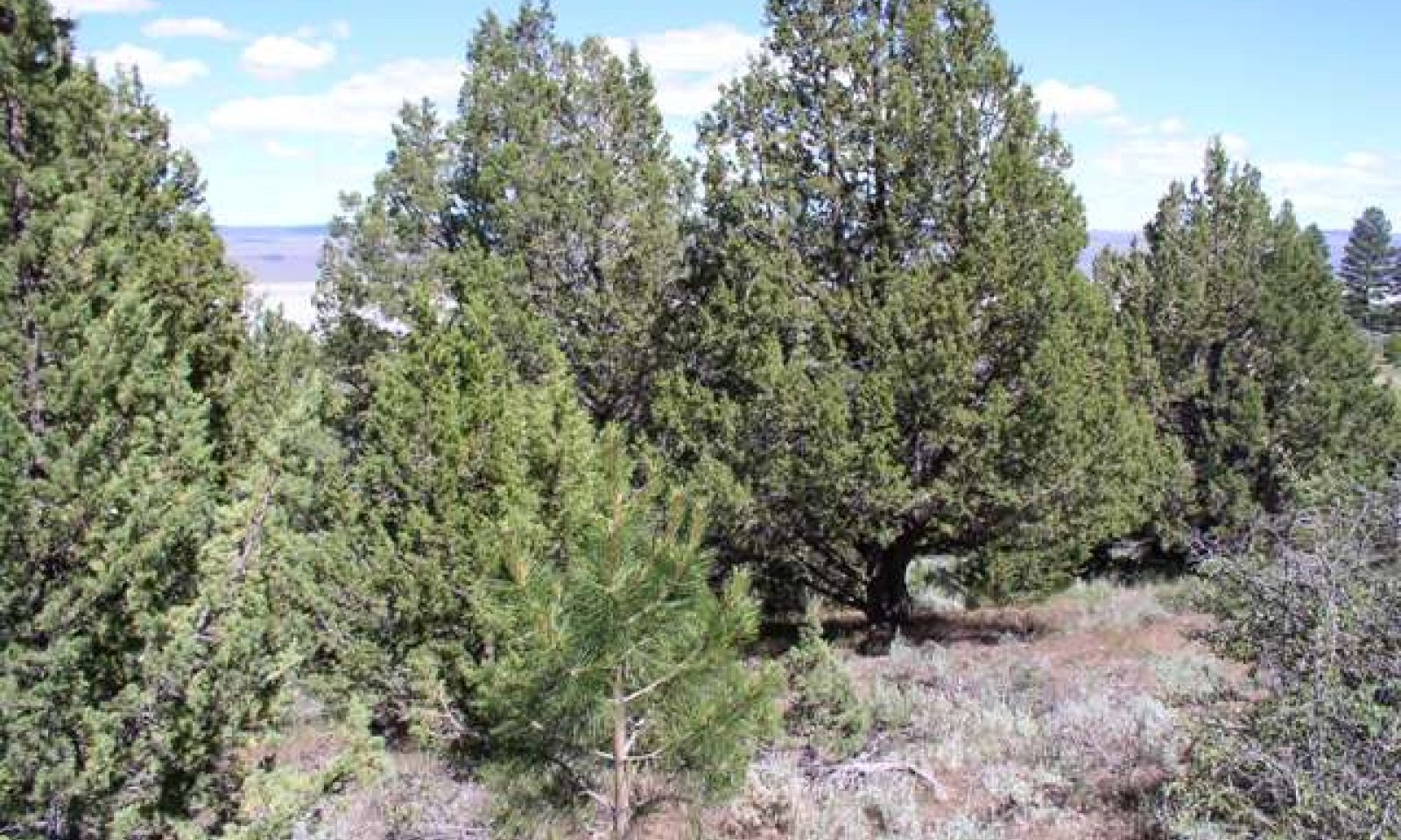
The reference plant community is dominated by western juniper. An open forest with an understory of shrubs and perennial grasses and forbs is characteristic of this site. An overstory canopy of 30 percent is assumed to be representative of tree dominance on this site in the pristine environment. Mountain big sagebrush is the principal understory shrub. Thurber's needlegrass, Sandberg bluegrass and bluebunch wheatgrass are the most prevalent understory grasses. Approximate ground cover (basal and crown) is 25 to 35 percent.
Forest overstory.MATURE FORESTLAND: The visual aspect and vegetal structure are dominated by western juniper trees that have reached or are near maximal heights for the site. Dominant trees average greater than five inches in diameter at one-foot stump height. Tree canopy cover ranges from 20 to 35 percent. Understory vegetation is strongly influenced by tree competition, overstory shading, duff accumulation, etc. Few tree seedlings and/or saplings occur in the understory. Infrequent, yet periodic wildfire is a natural factor influencing the understory of mature western juniper forests.
Forest understory. Understory vegetative composition is about 50 percent grasses, 15 percent forbs and 36 percent shrubs and young trees when the average overstory canopy is medium (20 to 35 percent). Average understory production ranges from 300 to 700 pounds per acre with a medium canopy cover. Understory production includes the total annual production of all species within 4.5 feet of the ground surface.
Figure 3. Annual production by plant type (representative values) or group (midpoint values)
Table 5. Annual production by plant type
Plant type Low
(lb/acre)Representative value
(lb/acre)High
(lb/acre)Grass/Grasslike 150 250 350 Shrub/Vine 90 150 210 Forb 45 75 105 Tree 15 25 35 Total 300 500 700 Additional community tables
Table 6. Community 1.1 plant community composition
Group Common name Symbol Scientific name Annual production () Foliar cover (%) Grass/Grasslike1 Primary Perennial Grasses 100–210 Thurber's needlegrass ACTH7 Achnatherum thurberianum 50–120 – Sandberg bluegrass POSE Poa secunda 25–45 – bluebunch wheatgrass PSSPS Pseudoroegneria spicata ssp. spicata 25–45 – 2 Secondary Perennial Grasses/Grasslikes 15–75 sedge CAREX Carex 5–25 – big squirreltail ELMU3 Elymus multisetus 5–25 – basin wildrye LECI4 Leymus cinereus 5–25 – Forb3 Perennial 25–75 tapertip hawksbeard CRAC2 Crepis acuminata 5–25 – woolly mule-ears WYMO Wyethia mollis 5–25 – buckwheat ERIOG Eriogonum 3–5 – sulphur-flower buckwheat ERUM Eriogonum umbellatum 3–5 – spreading dogbane APAN2 Apocynum androsaemifolium 3–5 – milkvetch ASTRA Astragalus 3–5 – trumpet COLLO Collomia 3–5 – Shrub/Vine4 Primary Shrubs 50–120 mountain big sagebrush ARTRV Artemisia tridentata ssp. vaseyana 50–120 – 5 Secondary Shrubs 19–65 Utah serviceberry AMUT Amelanchier utahensis 5–25 – antelope bitterbrush PUTR2 Purshia tridentata 5–25 – wax currant RICE Ribes cereum 3–5 – roundleaf snowberry SYRO Symphoricarpos rotundifolius 3–5 – rubber rabbitbrush ERNAS2 Ericameria nauseosa ssp. nauseosa var. speciosa 3–5 – Tree6 Evergreen 11–35 western juniper JUOC Juniperus occidentalis 5–25 – ponderosa pine PIPO Pinus ponderosa 3–5 – Table 7. Community 1.1 forest overstory composition
Common name Symbol Scientific name Nativity Height ft Canopy cover (%) Diameter in Basal area (square ft/acre) Treewestern juniper JUOC Juniperus occidentalis Native – 95-100 – 0 ponderosa pine PIPO Pinus ponderosa Native – 0-3 – 0 Interpretations
Animal community
Livestock Interpretations:
This site is suited to cattle and sheep grazing during the spring, summer and fall. Grazing management should be keyed to bluebunch wheatgrass and Thurber’s needlegrass production. These grasses are highly nutritious and will usually remain green throughout the growing season. New plants are established entirely from seed and grazing management practices should allow for ample seed production and seedling establishment. Livestock will often concentrate on this site taking advantage of the shade and shelter offered by the tree overstory. Many areas are not used because of steep slopes and lack of adequate water. Attentive grazing management is required due to steep slopes and associated erosion hazards. Harvesting trees under a sound management program for fuelwood, posts or other products can open the tree canopy to allow increased production of understory species desirable for grazing. Thurber’s needlegrass species begin growth early in the year and remain green throughout a relatively long growing season. This pattern of development enables animals to use Thurber’s needlegrass when many other grasses are unavailable. Cattle prefer Thurber’s needlegrass in early spring before fruits have developed as it becomes less palatable when mature. Thurber’s needlegrasses are grazed in the fall only if the fruits are softened by rain. Sandberg bluegrass is a palatable species, but its production is closely tied to weather conditions. It produces little forage in drought years, making it a less dependable food source than other perennial bunchgrasses. Bluebunch wheatgrass is considered one of the most important forage grass species on western rangelands for livestock. Although bluebunch wheatgrass can be a crucial source of forage, it is not necessarily the most highly preferred species. Mountain big sagebrush is eaten by domestic livestock but has long been considered to be of low palatability, and a competitor to more desirable species.
Stocking rates vary over time depending upon season of use, climate variations, site, and previous and current management goals. A safe starting stocking rate is an estimated stocking rate that is fine tuned by the client by adaptive management through the year and from year to year.
Wildlife Interpretations:
Thurber needlegrass is valuable forage for wildlife. Sandberg bluegrass is desirable for pronghorn antelope and mule deer in the spring and preferable in the spring, summer, and fall for elk and desirable as part of their winter range. Bluebunch wheatgrass is considered one of the most important forage grass species on western rangelands for wildlife. Bluebunch wheatgrass does not generally provide sufficient cover for ungulates, however, mule deer are frequently found in bluebunch-dominated grasslands. Mountain big sagebrush is highly preferred and nutritious winter forage for mule deer and elk. Western juniper provides food and cover for a variety of bird and mammal species. This site has high value for mule deer during the winter. Juniper trees provide shelter from winter storms and juniper foliage is also browsed by mule deek and elk during the winter. Sites where water is available offer good chukar habitat and are visited seasonally by mourning dove. It is also used by various song birds, rodents, reptiles and associated predators natural to the area. The foliage and cone-berries of western juniper are important foods for a number of mammals. Mule deer, elk, mountain cottontail, and coyote consume western juniper cone-berries. Western juniper cone-berries provide food for coyotes, small mammals and wintering birds.Hydrological functions
Runoff is medium to high. The hydrologic cover condition of this site is fair in a representative stand. The average runoff curve is about 90 for group D. Soils. (See Section 4, NRCS National Engineering Handbook for runoff quantities and hydrologic curves.)
Recreational uses
This site has value for for hiking, bird watching, camping, and deer and upland game hunting.
Wood products
Western juniper has been used since historic times for firewood, charcoal, corrals, poles, and fence posts. The wood is extremely durable and resistant to rot. Juniper wood splits easily, burns clean, and produces little ash.
In recent times, western juniper has been used for paneling, interior studs, particleboard, veneer, plywood, and other lumber products.
This forestland community is of moderate site quality for juniper tree production. Site index ranges from about 20 to 30 (Sauerwein, 1982).
PRODUCTIVITY CAPACITY
Fuelwood Production: About 10 to 15 cords per acre. There are about 274,000 gross British Thermal Units (BTUs) heat content per cubic foot of western juniper wood. Firewood is commonly measured by cord, or a stacked unit equivalent to 128 cubic feet. Solid wood volume in a cord varies, but usually ranges from 65 to 90 cubic feet. Assuming an average of 75 cubic feet of solid wood per cord, there are about 21 million BTUs of heat value in a cord of western juniper wood.
Posts (7 foot): 30 to 40 posts per acre in stands of medium canopy.
SILVICULTURAL PRACTICES
a. Harvest cut selectively or in small patches (size dependent upon site conditions) to enhance forage production.
1) Thinning and Improvement Cutting - Removal of poorly formed, diseased, and low vigor trees for fuel wood.
2) Harvest Cutting - Selectively harvest surplus trees to achieve desired spacing. Selective harvesting can provide income as well as improve stand quality and yield. Tree harvest will also open overstory canopy to increase understory herbaceous production desirable for grazing by livestock and big game. Do not select only "high grade" trees during harvest.
3) Slash Disposal - Broadcasting slash enhances reestablishment of native understory species and establishment of seeded grasses and forbs after tree harvest.
4) Spacing Guide - D+9
b. Prescription burning program to maintain desired canopy cover and manage site reproduction.
c. Mechanical tree removal (i.e., chaining) on suitable sites to enhance forage production and manage site reproduction.
d. Pest control - Porcupines can cause extensive damage,and populations should be controlled.
e. Fire hazard - Fire usually not a problem in mature, grazed stands.Other products
Western juniper has been cultivated as an ornamental since 1840. Juniper boughs have been used for Christmas wreaths and other decorations. The essential oils of western juniper are used for flavoring or scenting agents in medicines, beverages, condiments, aerosols, insecticides, soaps, and men's cosmetics. The cone-berries of western juniper are edible and taste best when dried. Western juniper foliage has been added to chicken feed to produce gin-flavored eggs for human consumption. Some Native American peoples traditionally used western juniper wood in making bow staves.
Other information
Western juniper can be propagated from cuttings or by layering. Trees have been used as riprap for stabilizing streambanks. The Northern Paiute Indians used western juniper for food, medicine, and shelter. The leaves, small branches, and berries were boiled and the pitch skimmed off the surface to treat colds, sore throats, venereal disease, kidneys and boils. The berries and white inner bark were eaten during food shortages. Juniper pitch was used on baskets to make watertight containers. Western juniper was also used to make bows and wickiups.
Table 8. Representative site productivity
Common name Symbol Site index low Site index high CMAI low CMAI high Age of CMAI Site index curve code Site index curve basis Citation western juniper JUOC 20 30 28 32 – – – Supporting information
Type locality
Location 1: Modoc County, CA Township/Range/Section T45N R16E S6 UTM zone N UTM northing 733667 UTM easting 4631197 Latitude 41° 47′ 53″ Longitude 120° 11′ 15″ General legal description North of Fandango Pass Road, Warner Mountains, Modoc National Forest, Modoc County, California Other references
Fire Effects Information System (Online; http://www.fs.fed.us/database/feis/plants/).
Miles, S.R. and C.B. Goudey. 1997. Ecological Subregions of California Section and Subsection Descriptions. United States Department of Agriculture Forest Service, Pacific Southwest Region R5-EM-TP-005. Subsection M261Gf-Warner Mountains.
Miller, R.F., J.D. Bates, T.J. Svejcar, F.B. Pierson, and L.E. Eddleman. 2005. Biology, Ecology, and Management of Western Juniper. Oregon State University, Agricultural Experiment Station Technical Bulletin 152.
Sauerwein, W.J. 1982. Western Juniper Site Index Curves, USDA-NRCS, WNTC Technical Note WOOD-14.
Tirmenstein, D. 1999. Juniperus occidentalis. In: Fire Effects Information System, [Online]. U.S. Department of Agriculture, Forest Service, Rocky Mountain Research Station, Fire Sciences Laboratory (Producer).
USDA-NRCS. 2000 National Forestry Manual - Part 537. Washington, D.C.
USDA-NRCS. 2004 National Forestry Handbook, Title 190. Washington, D. C.
USDA-NRCS Plants Database (Online; http://www.plants.usda.gov).
Young, J.A. and R.A. Evans 1981. Demography and fire history of a western juniper stand. J. Range Manage 34(6):501-505.Contributors
P.NOVAK-ECHENIQUE
Rangeland health reference sheet
Interpreting Indicators of Rangeland Health is a qualitative assessment protocol used to determine ecosystem condition based on benchmark characteristics described in the Reference Sheet. A suite of 17 (or more) indicators are typically considered in an assessment. The ecological site(s) representative of an assessment location must be known prior to applying the protocol and must be verified based on soils and climate. Current plant community cannot be used to identify the ecological site.
Author(s)/participant(s) Contact for lead author Date Approved by Approval date Composition (Indicators 10 and 12) based on Annual Production Indicators
-
Number and extent of rills:
-
Presence of water flow patterns:
-
Number and height of erosional pedestals or terracettes:
-
Bare ground from Ecological Site Description or other studies (rock, litter, lichen, moss, plant canopy are not bare ground):
-
Number of gullies and erosion associated with gullies:
-
Extent of wind scoured, blowouts and/or depositional areas:
-
Amount of litter movement (describe size and distance expected to travel):
-
Soil surface (top few mm) resistance to erosion (stability values are averages - most sites will show a range of values):
-
Soil surface structure and SOM content (include type of structure and A-horizon color and thickness):
-
Effect of community phase composition (relative proportion of different functional groups) and spatial distribution on infiltration and runoff:
-
Presence and thickness of compaction layer (usually none; describe soil profile features which may be mistaken for compaction on this site):
-
Functional/Structural Groups (list in order of descending dominance by above-ground annual-production or live foliar cover using symbols: >>, >, = to indicate much greater than, greater than, and equal to):
Dominant:
Sub-dominant:
Other:
Additional:
-
Amount of plant mortality and decadence (include which functional groups are expected to show mortality or decadence):
-
Average percent litter cover (%) and depth ( in):
-
Expected annual annual-production (this is TOTAL above-ground annual-production, not just forage annual-production):
-
Potential invasive (including noxious) species (native and non-native). List species which BOTH characterize degraded states and have the potential to become a dominant or co-dominant species on the ecological site if their future establishment and growth is not actively controlled by management interventions. Species that become dominant for only one to several years (e.g., short-term response to drought or wildfire) are not invasive plants. Note that unlike other indicators, we are describing what is NOT expected in the reference state for the ecological site:
-
Perennial plant reproductive capability:
Print Options
Sections
Font
AAAAOther
PrintThe Ecosystem Dynamics Interpretive Tool is an information system framework developed by the USDA-ARS Jornada Experimental Range, USDA Natural Resources Conservation Service, and New Mexico State University.
Accessibility statement


