
Natural Resources
Conservation Service
Ecological site F021XE235CA
Pinus albicaulis/Ribes montigenum/Achnatherum occidentale ssp. occidentale
Accessed: 08/29/2026
-
Search


Major Land Resource Area or ecological site by name and/or ID.
PreviousSectionsNextGeneral information
Draft. A draft ecological site description is either incomplete or has not undergone quality control and quality assurance review.
Classification relationships
Fire Effects Information System (Online; http://www.fs.fed.us/database/feis/plants/).
Holland, R.F. 1986. Preliminary descriptions of the terrestrial natural communities of California. Unpublished report. State of California, The Resources Agency, Department of Fish and Game, Natural Heritage Division, Sacramento, CA. Element Code: 86220 - Whitebark Pine - Lodgepole Pine Forest
Sawyer, J.O. and T. Keeler-Wolf 1995. A manual of California vegetation. Whitebark Pine Series.
Smith, S. and B. Davidson. 2003. User's Manual Terrestrial Ecological Unit Inventory (TEUI) Land Type Associations, Modoc National Forest. Whitebark Pine Series.
USDA-NRCS. 2000 National Forestry Manual - Part 537. Washington, D.C.
USDA-NRCS. 2004 National Forestry Handbook, Title 190. Washington, D. C.
USDA-NRCS Plants Database (Online; http://www.plants.usda.gov).
Associated sites
F021XE232CA Pinus contorta var. murrayana/Arctostaphylos nevadensis/Carex rossii
F021XE233CA Populus tremuloides/Symphoricarpos rotundifolius-Artemisia tridentata ssp. vaseyana/Bromus marginatus
F021XE239CA Abies concolor var. lowiana-Pinus monticola/Achnatherum occidentale ssp. occidentale
R021XE222CA Loamy Slope 30+ P.Z.
Similar sites
F021XE232CA Pinus contorta var. murrayana/Arctostaphylos nevadensis/Carex rossii
Site is dominated by PICOM, PIAL minor component in the overstory.
Table 1. Dominant plant species
Tree (1) Pinus albicaulis
Shrub (1) Ribes montigenum
Herbaceous (1) Achnatherum occidentale ssp. occidentale
Physiographic features
This site occurs on upper mountain sideslopes and mountain summits. Slopes range from 4 to 50 percent slopes. Elevations range from 7100 to 9700 feet. The mean annual temperature is 32 to 44 degrees F and mean annual precipitation is 30 to 50 inches.
Table 2. Representative physiographic features
Landforms (1) Mountain slope
Elevation 7100 – 9700 ft Slope 4 – 50 % Aspect Aspect is not a significant factor Climatic features
The climate of this site is subhumid, characterized by warm, dry summers and cold, moist winters. The area's precipitation comes mostly from winter Pacific cyclonic storms, with a very slight summer monsoonal season that is erratic but can be locally significant. Average annual precipitation is greater than 30 inches with most occurring during the winter months. Approximately half the precipitation falls as snow; half as rain. The frost-free period is from 30 to 60 days.
Table 3 Representative climatic features
Frost-free period (average) 60 days Freeze-free period (average) 0 days Precipitation total (average) 50 in BarLineFigure 1. Monthly precipitation range
BarLineFigure 2. Monthly average minimum and maximum temperature
">Influencing water features
There are no influencing water features associated with this site.
Soil features
The soils associated with this site are moderately deep, well drained soils that formed in volcanic ash and colluvium over residuum derived from glassy tuff. These soils have high amounts of vitric volcanic ash and glass throughout the profile which enhances the waterholding capacity. The soil profile is modified with 60 to 80 percent rock fragments. An ochric epipedon occurs from the soil surface to 7 inches. Soils associated with this site include Gurlidawg.
Table 4. Representative soil features
Parent material (1) Colluvium – tuff
Surface texture (1) Ashy loam
Family particle size (1) Loamy
Drainage class Well drained Permeability class Moderate Soil depth 20 – 40 in Surface fragment cover <=3" 35 – 45 % Surface fragment cover >3" 10 – 12 % Available water capacity
(0-40in)4 – 4.1 in Calcium carbonate equivalent
(0-40in)Not specified Electrical conductivity
(0-40in)Not specified Sodium adsorption ratio
(0-40in)Not specified Soil reaction (1:1 water)
(0-40in)5.1 – 6.5 Subsurface fragment volume <=3"
(Depth not specified)43 – 65 % Subsurface fragment volume >3"
(Depth not specified)0 – 5 % Ecological dynamics
Major Successional Stages of Forestland Development:
HERBACEOUS: Vegetation is dominated by grasses and forbs under full sunlight. This stage is experienced after a major disturbance such as crown fire or tree harvest. Skeleton forest (dead trees) remaining after fire or residual trees left following harvest have little affect on the composition and production of the herbaceous vegetation.
SHRUB-HERBACEOUS: Herbaceous vegetation and woody shrubs dominate the site. Various amounts of conifer tree seedlings (less than 20 inches in height) may be present up to the point where they are obviously a major component of the vegetal structure.
SAPLING: In the absence of disturbance, the conifer seedlings develop into saplings (20 inches to 4½ feet in height) with a range in canopy cover of about 5 to 10 percent. Vegetation consists of grasses, forbs and shrubs in association with whitebark pine, western white pine, lodgepole pine, and white fir saplings.
IMMATURE FORESTLAND: The visual aspect and vegetal structure are dominated by whitebark pine greater than 4½ feet in height. Seedlings and saplings of westerh white pine, white fir and lodgepole pine are present in the understory. Understory vegetation is moderately influenced by a tree overstory canopy of about 10 to 20 percent.
MATURE FORESTLAND: The visual aspect and vegetal structure are dominated by whitebark pine that have reached or are near maximal heights for the site. Dominant trees average ten inches or greater in diameter at breast height. Tree canopy cover is about 35 percent. Understory vegetation is strongly influenced by tree competition, overstory shading, duff accumulation, etc.
OVER-MATURE FORESTLAND: In the absence of wildfire or other naturally occurring disturbances, the tree canopy on this site can become dense. This stage is dominated by whitebark pine that have reached maximal heights for the site. Dominant and codominant trees average greater than ten inches in diameter at breast height. Understory vegetation is sparse due to tree competition, overstory shading, duff accumulation, etc. Canopy cover is commonly greater than 35 percent.
Climax communities of whitebark pine are relatively open and favorable to establishment of this moderately shade-tolerant species. Clark's nutcrackers, by caching seed in forested sites, maintain climax communities of whitebark pine. Nutcrackers are attracted to open sites for seed caching and are efficient in seeding burned areas. Natural perturbations are important in shaping the structure of whitebark pine communities. Climatic factors such as damaging winds, ice storms, snowloads, summer frost, and winter desiccation prevent stand closure. This rigorous microclimate also allows competition-intolerant species like whitebark pine to coexist indefinitely with their tolerant competitors.
Whitebark pine wood is highly flammable even when green. Fire severity is low where surface fuels are sparse, and the resulting underburn kills mostly small trees and fire-susceptible overstory species, leaving live, mature whitebark pine. Whitebark pine seedlings establish on open sites created by fires. Late-successional species dominate when fire return intervals are long, but fires were historically likely to return before whitebark pine was successionally replaced. Although whitebark pine recruitment is depressed in many areas, whitebark pine seedlings were historically highly competitive with other conifer species in the postfire environment.
Fire Ecology:
Fire kills gooseberry, however, regeneration is favored by fire because scarification of soil-stored seed generally enhances germination in gooseberry. Western needlegrass is moderately damaged by fire. The recovery time is between 3 and 5 years. Ross’ sedge survives fire through buried seed with long-term viability. These seeds germinate after heat treatment. Ross’ sedge’s rhizomes survive low- to moderate-severity fires. Whitebark pine ecosystems have a mixed-severity fire regime of widely ranging fire intensities and frequencies. Prior to 1900, fire return intervals ranged from 30 to 350+ years. Lightning is the major cause of fires in most stands although accidental fires have resulted due to increased recreation activity in these forests. Mixed-severity fires create complex landscapes of dead whitebark pine stands intermingled with live stands of different ages. Whitebark pine stands also experience nonlethal surface fires and infrequent stand-replacement fires. Infrequent stand-replacement fires and small patch fires are important components of whitebark pine's fire ecology. Two strategies allow whitebark pine to survive in fire-prone ecosystems: survival of large trees, and postfire seedling establishment facilitated by Clark's nutcrackers.State and transition model
More interactive model formats are also available. View Interactive Models
Click on state and transition labels to scroll to the respective textEcosystem states
State 1 submodel, plant communities
State 1
Reference StateCommunity 1.1
Reference Plant Community
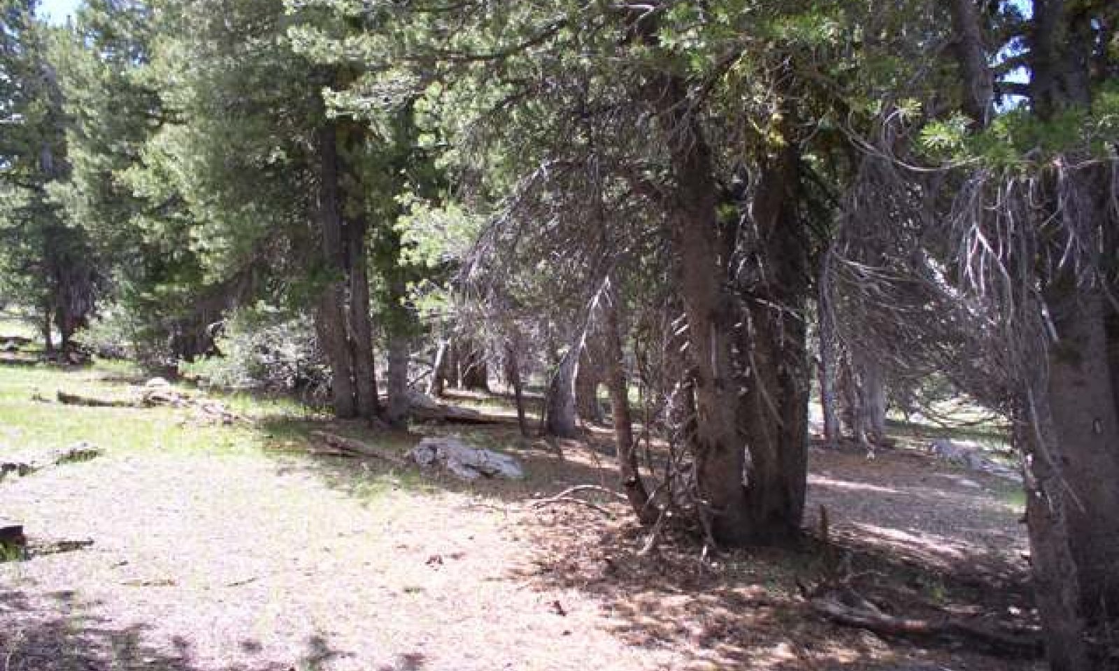
The reference plant community is characterized as an open or clumped timberline forest to about 40 feet tall, dominated by whitebark pine. Other conifer species such as white fir, western white pine, and lodgepole pine may comprise up to 5 percent of the canopy cover. The understory is low and sparse and is predominantly comprised of perennial forbs and grasses. Tree canopy cover ranges from 30 to 45 percent.
Forest overstory.MATURE FORESTLAND: The visual aspect and vegetal structure are dominated by whitebark pine that have reached or are near maximal heights for the site. Dominant trees average ten inches or greater in diameter at breast height. Tree canopy cover is about 35 percent. Understory vegetation is strongly influenced by tree competition, overstory shading, duff accumulation, etc.
Forest understory. Understory composition is about 55 percent grasses, 20 percent forbs, and 25 percent shrubs and young trees when the average overstory canopy is medium (35 percent). average understory production ranges from 50 to 300 pounds per care with a medium canopy cover. Understory production includes the total annual production of all species within 4 1/2 feet of the ground surface.
Figure 3. Annual production by plant type (representative values) or group (midpoint values)
Table 5. Annual production by plant type
Plant type Low
(lb/acre)Representative value
(lb/acre)High
(lb/acre)Grass/Grasslike 28 96 165 Shrub/Vine 10 35 60 Forb 10 35 60 Tree 2 9 15 Total 50 175 300 Additional community tables
Table 6. Community 1.1 plant community composition
Group Common name Symbol Scientific name Annual production () Foliar cover (%) Grass/Grasslike1 Primary Perennial Grasses/Grasslikes 45–100 California needlegrass ACOCC Achnatherum occidentale ssp. californicum 18–42 – western needlegrass ACOCO Achnatherum occidentale ssp. occidentale 18–42 – Ross' sedge CARO5 Carex rossii 9–16 – 2 Secondary Perennial Grasses 8–36 prairie Junegrass KOMA Koeleria macrantha 2–9 – Cusick's bluegrass POCUE2 Poa cusickii ssp. epilis 2–9 – Wheeler's bluegrass POWH2 Poa wheeleri 2–9 – spike trisetum TRSP2 Trisetum spicatum 2–9 – 3 Perennial 17–39 prickly sandwort ARAC2 Arenaria aculeata 2–9 – Lyall's rockcress ARLY Arabis lyallii 1–2 – cobwebby Indian paintbrush CAAR11 Castilleja arachnoidea 1–2 – Mt. Hood pussypaws CIUMU Cistanthe umbellata var. umbellata 1–2 – rabbitbush ERBL2 Ericameria bloomeri 1–2 – naked buckwheat ERNU3 Eriogonum nudum 1–2 – elkweed FRSP Frasera speciosa 1–2 – desertparsley LOMAT Lomatium 1–2 – tailcup lupine LUCAC3 Lupinus caudatus ssp. caudatus 1–2 – Davidson's penstemon PEDA2 Penstemon davidsonii 1–2 – slender penstemon PEGR4 Penstemon gracilentus 1–2 – low phacelia PHHU Phacelia humilis 1–2 – cold-desert phlox PHST11 Phlox stansburyi 1–2 – goosefoot violet VIPU4 Viola purpurea 1–2 – pale agoseris AGGL Agoseris glauca 1–2 – Drummond's anemone ANDR Anemone drummondii 1–2 – Shrub/Vine4 Primary Shrubs 27–58 gooseberry currant RIMO2 Ribes montigenum 18–42 – roundleaf snowberry SYRO Symphoricarpos rotundifolius 9–16 – 5 Secondary Shrubs 2–9 mountain big sagebrush ARTRV Artemisia tridentata ssp. vaseyana 2–9 – Tree6 Evergreen 4–13 whitebark pine PIAL Pinus albicaulis 2–9 – Sierra lodgepole pine PICOM Pinus contorta var. murrayana 1–2 – Table 7. Community 1.1 forest overstory composition
Common name Symbol Scientific name Nativity Height ft Canopy cover (%) Diameter in Basal area (square ft/acre) Treewhitebark pine PIAL Pinus albicaulis Native – 95-100 – 0 Sierra lodgepole pine PICOM Pinus contorta var. murrayana Native – 0-3 – 0 Interpretations
Animal community
Livestock Interpretations:
This site provides limited use for livestock grazing due to low forage production. Western needlegrass has a spreading and deeply penetrating root system, which makes it resistant to trampling. Ross' sedge may be a poor to good forage plant depending on the site. Palatability of Ross' sedge has been rated "fair" for domestic sheep, horses, cattle, and small mammals. Gooseberry currant is not very palatable to livestock. Snowberry is readily eaten by all classes of livestock, particularly domestic sheep.
Stocking rates vary over time depending upon season of use, climate variations, site, and previous and current management goals. A safe starting stocking rate is an estimated stocking rate that is fine tuned by the client by adaptive management through the year and from year to year.
Wildlife Interpretations:
Western needlegrass provides valuable forage for many species of wildlife. Ross' sedge is important summer elk forage, particularly in the first half of the growing season. It has been rated "good" for elk and "poor" for mule deer and pronghorn antelope. The fruit of Ribes spp. is a valuable food source for songbirds, chipmunks, ground squirrels, and other animals. Snowberry is an important forage species for deer and elk on high elevation summer ranges. Snowberry is frequently one of the first species to leaf out, making it a highly sought after food in the early spring. Whitebark pine is a valuable source of food and cover for many species of wildlife. Bears, rodents, and birds consume the seeds. The trunks provide nesting sites for cavity nesters. Whitebark pine is a minor browse species for big game, but whitebark pine understories often provide valuable forage. Mule deer consume trace amounts of whitebark pine. Whitebark pine provides ecologically critical linkage between Clark's nutcracker and lower-elevation, Clark's nutcracker-dependant pin. When the seed crop of a pine species is insufficient, Clark's nutcrackers migrate up- or downslope to harvest species with more bountiful seed crops. Loss of whitebark pine, their preferred species, reduces Clark's nutcracker populations, and may have negative consequences for other pine species with seeds dispersed by Clark's nutcrackers.Hydrological functions
Whitebark pine sites are highly valuable watersheds. The open canopies of whitebark pine communities slow snowmelt and retain more snowpack than the closed canopies of late-succession communities. Runoff is high to very high depending on slope.
Recreational uses
Whitebark pine is valued for its beauty, and whitebark pine ecosystems are suitable for birdwatching, hunting, camping and hiking.
Wood products
Mainly due to the species' inaccessibility, whitebark pine wood is not considered commercially valuable. Large-diameter whitebark pine in mixed stands were harvested in the past. Whitebark pine is classified as a soft-wood pine.
Other products
Currants (Ribes spp.) can be used for making jam, jelly, or pie. Some western Indian tribes used currants for making pemmican. Whitebark pine can be used as an ornamental in landscape plantings. Whitebark pine can be grown in the nursery from seed. Transplanted whitebark pine has shown fair survivorship rates. Whitebark pine seeds were a food source for Native Americans.
Other information
Throughout much of its range, whitebark pine communities have experienced tremendous change over the past century from the affects of fire suppression, mountain pine beetle and blister rust. Fire suppression has contributed to change in habitat structure and functions. Blister rust, an introduced pathogen, is increasing whitebark pine mortality in these woodlands. fire suppression can lead to tree islands coalescing and the conversion of parklands into a more closed forest habitat. Parkland conditions can displace alpine conditions through tree invasions. Livestock use and heavy horse or foot traffic can lead to trampling and soil compaction. Slow growth in this habitat prevents rapid recovery.
Supporting information
Type locality
Location 1: Modoc County, CA Township/Range/Section T47N R16E S16 UTM zone N UTM northing 737173 UTM easting 4648155 Latitude 41° 56′ 59″ Longitude 120° 8′ 18″ General legal description Northwest of Bidwell Mountain peak, Warner Mountains, Modoc National Forest, Modoc County, California Contributors
P. NOVAK-ECHENIQUE
Rangeland health reference sheet
Interpreting Indicators of Rangeland Health is a qualitative assessment protocol used to determine ecosystem condition based on benchmark characteristics described in the Reference Sheet. A suite of 17 (or more) indicators are typically considered in an assessment. The ecological site(s) representative of an assessment location must be known prior to applying the protocol and must be verified based on soils and climate. Current plant community cannot be used to identify the ecological site.
Author(s)/participant(s) Contact for lead author Date Approved by Approval date Composition (Indicators 10 and 12) based on Annual Production Indicators
-
Number and extent of rills:
-
Presence of water flow patterns:
-
Number and height of erosional pedestals or terracettes:
-
Bare ground from Ecological Site Description or other studies (rock, litter, lichen, moss, plant canopy are not bare ground):
-
Number of gullies and erosion associated with gullies:
-
Extent of wind scoured, blowouts and/or depositional areas:
-
Amount of litter movement (describe size and distance expected to travel):
-
Soil surface (top few mm) resistance to erosion (stability values are averages - most sites will show a range of values):
-
Soil surface structure and SOM content (include type of structure and A-horizon color and thickness):
-
Effect of community phase composition (relative proportion of different functional groups) and spatial distribution on infiltration and runoff:
-
Presence and thickness of compaction layer (usually none; describe soil profile features which may be mistaken for compaction on this site):
-
Functional/Structural Groups (list in order of descending dominance by above-ground annual-production or live foliar cover using symbols: >>, >, = to indicate much greater than, greater than, and equal to):
Dominant:
Sub-dominant:
Other:
Additional:
-
Amount of plant mortality and decadence (include which functional groups are expected to show mortality or decadence):
-
Average percent litter cover (%) and depth ( in):
-
Expected annual annual-production (this is TOTAL above-ground annual-production, not just forage annual-production):
-
Potential invasive (including noxious) species (native and non-native). List species which BOTH characterize degraded states and have the potential to become a dominant or co-dominant species on the ecological site if their future establishment and growth is not actively controlled by management interventions. Species that become dominant for only one to several years (e.g., short-term response to drought or wildfire) are not invasive plants. Note that unlike other indicators, we are describing what is NOT expected in the reference state for the ecological site:
-
Perennial plant reproductive capability:
Print Options
Sections
Font
AAAAOther
PrintThe Ecosystem Dynamics Interpretive Tool is an information system framework developed by the USDA-ARS Jornada Experimental Range, USDA Natural Resources Conservation Service, and New Mexico State University.
Accessibility statement


