
Natural Resources
Conservation Service
Ecological site R010XC029OR
SR Shallow Cool
12-16 PZ
Last updated: 4/18/2025
Accessed: 08/29/2026
-
Search


Major Land Resource Area or ecological site by name and/or ID.
PreviousSectionsNextGeneral information
Provisional. A provisional ecological site description has undergone quality control and quality assurance review. It contains a working state and transition model and enough information to identify the ecological site.
MLRA notes
Major Land Resource Area (MLRA): 010X–Central Rocky and Blue Mountain Foothills
This MLRA is characterized by gently rolling to steep hills, plateaus, and low mountains at the foothills of the Blue Mountains in Oregon and the Central Rocky Mountains in Idaho. The geology of this area is highly varied and ranges from Holocene volcanics to Cretaceous sedimentary rocks. Mollisols are the dominant soil order and the soil climate is typified by mesic or frigid soil temperature regimes, and xeric or aridic soil moisture regimes. Elevation ranges from 1,300 to 6,600 feet (395 to 2,010 meters), increasing from west to east. The climate is characterized by dry summers and snow dominated winters with precipitation averaging 8 to 16 inches (205 to 405 millimeters) and increasing from west to east. These factors support plant communities with shrub-grass associations with considerable acreage of sagebrush grassland. Big sagebrush, bluebunch wheatgrass, and Idaho fescue are the dominant species. Stiff sagebrush, low sagebrush, and Sandberg bluegrass are often dominant on sites with shallow restrictive layers. Western juniper is one of the few common tree species and since European settlement has greatly expanded its extent in Oregon. Nearly half of the MLRA is federally owned and managed by the Bureau of Land Management. Most of the area is used for livestock grazing with areas accessible by irrigation often used for irrigated agriculture.
Ecological site concept
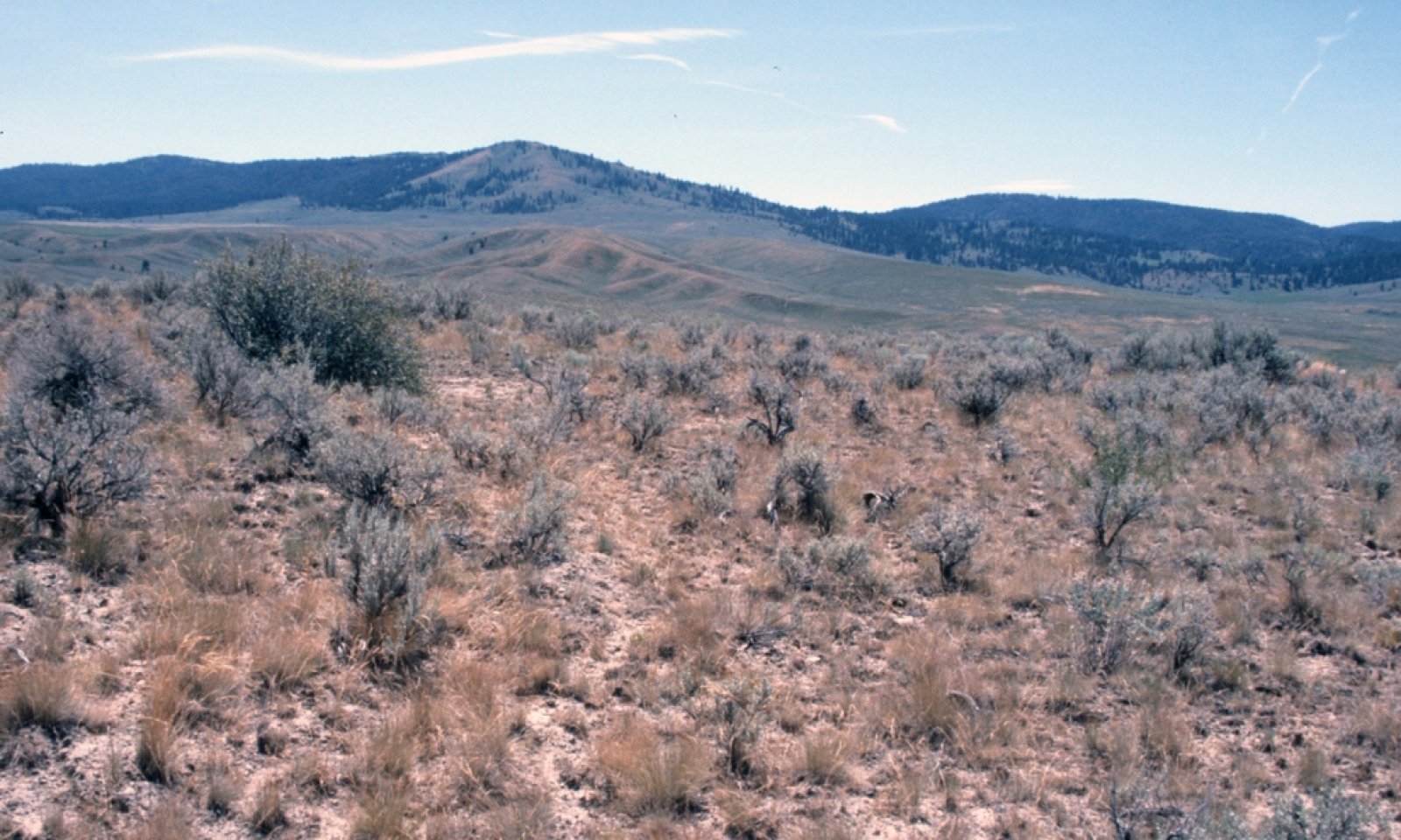
The potential native plant community is dominated by Idaho fescue and a complex of mountain, xeric and basin big sagebrush. Bluebunch wheatgrass and Sandberg bluegrass are common along with a variety of forbs. Thurber’s needlegrass, wild crab apple, and antelope bitterbrush occur sporadically. Vegetative composition of the community is approximately 70 percent grasses, 10 percent forbs and 20 percent shrubs. Approximate ground cover is 70 to 80 percent (basal and crown).
The soils of this site are shallow over bedrock or duripan. The surface layer is typically very cobbly to stony and the subsoil is very cobbly silty clay loam to stony clay loam over an extremely cobbly clay.
Idaho fescue increases on silt loam surfaces and at higher elevations. Bluebunch wheatgrass increases at lower elevations and on slight south and west exposures. Mountain big sagebrush increases in relationship to xeric and basin big sagebrush with elevation. Wyoming big sagebrush increases at lower elevation and on shallower soils. Thurber’s needlegrass increases on coarse surfaces. Antelope bitterbrush and wild crab apple increase over fractured substratums. Production increases with soil depth and precipitation.Associated sites
R010XC068OR SR Cool Mountain North 12-16 PZ
SR Cool Mountain North 12-16 PZ (greater soil depth, north aspect, higher production)
R010XC047OR SR Mountain South 12-16 PZ
SR Mountain South 12-16 PZ (greater soil depth, south aspect, higher production, different composition – higher proportion of PSSPS)
R010XC054OR SR Mountain Shallow South 12-16 PZ
SR Mountain Shallow South 12-16 PZ (south aspect, different composition – higher proportion of PSSPS)
R010XC075OR SR Mountain Shallow North 12-16 PZ
SR Mountain Shallow North 12-16 PZ (north aspect, different composition – higher proportion of ARTRV and FEID)
R010XC033OR SR Cool 12-16 PZ
SR Cool 12-16 PZ (greater soil depth, higher production)
R010XC039OR SR Very Shallow 12-16 PZ
SR Very Shallow 12-16 PZ (very shallow soil depth, lower production, different composition – ARRI2/POSE association)
R010XC041OR SR Very Shallow Rockland 12-16 PZ
SR Very Shallow Rockland 12-16 PZ (very shallow soil depth with areas of exposed bedrock, lower production, different composition – ACTH7-POSE/ERIOG association)
R010XC042OR SR Juniper Tableland 12-16 PZ
SR Juniper Tableland 12-16 PZ (very shallow soil depth, lower production, fractured substratum, different composition – JUOC/ARRI2/POSE association)
Similar sites
R010XC033OR SR Cool 12-16 PZ
SR Cool 12-16 PZ (greater soil depth, higher production)
R010XC075OR SR Mountain Shallow North 12-16 PZ
SR Mountain Shallow North 12-16 PZ (north aspect, different composition – higher proportion of ARTRV and FEID)
R010XC032OR SR Mountain 12-16 PZ
SR Mountain 12-16 PZ (higher elevation, greater soil depth, higher production, different composition – ARTRV and FEID strongly dominant)
R010XC037OR SR Mountain Shallow 12-16 PZ
SR Mountain Shallow 12-16 PZ (higher elevation, different composition – ARTRV and FEID strongly dominant)
Table 1. Dominant plant species
Tree Not specified
Shrub (1) Artemisia tridentata ssp. vaseyana
(2) Artemisia tridentata ssp. xericensisHerbaceous (1) Festuca idahoensis
(2) Pseudoroegneria spicata ssp. spicataPhysiographic features
This site occurs on terraces, tablelands and rolling uplands. Slopes typically range from 2 to 12 percent. Elevations typically range from 4,000 to 5,000 feet.
Table 2. Representative physiographic features
Landforms (1) Terrace
(2) Plateau
(3) Hill
Flooding frequency None Ponding frequency None Elevation 4000 – 5000 ft Slope 2 – 12 % Aspect Aspect is not a significant factor Climatic features
The annual precipitation ranges from 12 to 16 inches, most of which occurs in the form of snow during the months of December through March. Localized convection storms occasionally occur during the summer. The soil temperature regime is mesic near frigid to frigid with a mean air temperature of 45 degrees F. Temperature extremes range from 90 to -20 degrees F. The frost free period ranges from less than 50 to 90 days. The optimum growth period for plant growth is late April through June.
Table 3 Representative climatic features
Frost-free period (characteristic range) 50-90 days Freeze-free period (characteristic range) Precipitation total (characteristic range) 10-20 in Frost-free period (average) 90 days Freeze-free period (average) Precipitation total (average) 20 in BarLineFigure 1. Monthly precipitation range
BarLineFigure 2. Monthly average minimum and maximum temperature
">Influencing water features
Not associated with water features.
Wetland description
Not applicable
Soil features
The soils of this site are shallow over bedrock or duripan and well drained. The surface layer is typically a very cobbly silt loam to stony loam about 4 inches thick. The subsoil is a very cobbly silty clay loam to stony clay loam over an extremely cobbly clay. Depth to bedrock or an indurated pan ranges from 10 to 20 inches. Permeability is moderately slow to slow. The available water holding capacity (AWC) is about 2 to 4 inches for the profile. The erosion potential is moderate.
Table 4. Representative soil features
Parent material (1) Eolian deposits – rhyolite
(2) Volcanic ash – basalt
Surface texture (1) Very cobbly silt loam
(2) Stony loam
Family particle size (1) Clayey
Drainage class Well drained to moderately well drained Permeability class Moderately slow to slow Depth to restrictive layer 10 – 20 in Soil depth 10 – 20 in Surface fragment cover <=3" 0 – 10 % Surface fragment cover >3" 0 – 20 % Available water capacity
(0-40in)2 – 4 in Ecological dynamics
The potential native plant community is dominated by Idaho fescue and a complex of mountain, xeric, and basin big sagebrush. Bluebunch wheatgrass and Sandberg bluegrass are common along with a variety of forbs. Thurber’s needlegrass, wild crab apple, and antelope bitterbrush occur sporadically. Vegetative composition of the community is approximately 70 percent grasses, 10 percent forbs, and 20 percent shrubs. Approximate ground cover is 70 to 80 percent (basal and crown).
Range in Characteristics:
Idaho fescue increases on silt loam surfaces and at higher elevations. Bluebunch wheatgrass increases at lower elevations and on slight south and west exposures. Mountain big sagebrush increases in relationship to xeric and basin big sagebrush with elevation. Wyoming big sagebrush increases at lower elevation and on shallower soils. Thurber’s needlegrass increases on coarse surfaces. Antelope bitterbrush and wild crab apple increase over fractured substratums. Production increases with soil depth and precipitation.
Response to Disturbance - States:
If the condition of the site deteriorates as a result of overgrazing, Idaho fescue and Thurber’s needlegrass decrease. Bluebunch wheatgrass initially increases then decreases. Sandberg bluegrass and big sagebrush (mountain, basin, and xeric) increase. Western juniper invades from isolated rocky areas. With continued overgrazing and lack of fire juniper, sagebrush and Sandberg bluegrass dominate the site. Stiff sagebrush often invades from very shallow areas. In the continued absence of fire junipers increase in statue outcompeting shrubs and bare ground increases. Annual invasion is limited unless ground disturbance occurs. With fire and heavy use or ground disturbance, annuals and Sandberg or bulbous bluegrass dominate the site. Excess erosion in the bare soil interspaces markedly reduces the site productivity and contributes to downstream sedimentation.
States: ARTRV-X-T(W)/POSE-Bare Ground; JUOC/ARTRV-X- T(W)/POSE-Bare Ground; POSE-POBU -Annuals-Bare Ground
Juniper Response:
Fine fuel reduction from improper grazing and fire suppression has led to an increase in the historical fire return interval on many western rangelands. A reduction in fire frequency on these sites leads to an increase in juniper cover, a decrease in sagebrush cover followed by a decrease in herbaceous cover and understory diversity. As juniper encroaches sagebrush declines with a subsequent decrease in forbs, bluebunch wheatgrass and needlegrass. Idaho fescue becomes the primary herbaceous species occurring under the canopy of the juniper trees. Sandberg’s bluegrass increases in the plant community on lower elevation north slopes and warmer non-aspect sites while bare ground increases in the interspaces between trees. Bitterbrush is more resistant to juniper encroachment than sagebrush and maintains its presence in the community; however vigor and fitness (seed production) may be reduced. The potential for soil erosion increases as the juniper woodland matures and the understory plant community cover declines. The combined effect of overgrazing and juniper invasion increases the rate of decline in ecological function and the probability of crossing a threshold is high.
Treatment Response:
This site responds positively to juniper removal if soil erosion is not significant. Seeding may be necessary if there are less than one to two bunchgrass plants per meter square in the understory. Forbs may also need to be seeded if adult plants are no longer present in the understory.State and transition model
Custom diagramStandard diagram
More interactive model formats are also available. View Interactive Models
More interactive model formats are also available. View Interactive Models
Click on state and transition labels to scroll to the respective textEcosystem states
T1A - Continued Fire Suppression R2A - Mechanical Juniper Removal T2A - Soil Erosion State 1 submodel, plant communities
1.1A - Reduced fire and increased grazing 1.2A - Fire 1.2B - Reduced fire and increased grazing 1.3A - Fire 1.3B - Fire State 2 submodel, plant communities
2.1A - No Fire State 3 submodel, plant communities
State 1
ReferenceCommunity 1.1
Reference Plant Community - Perennial Forb and Grass Phase
The reference native plant community is dominated by Idaho fescue and a complex of mountain, xeric, and basin big sagebrush. Bluebunch wheatgrass and Sandberg bluegrass are common along with a variety of forbs. Thurber’s needlegrass, wild crab apple, and antelope bitterbrush occur sporadically. Vegetative composition of the community is approximately 70 percent grasses, 10 percent forbs, and 20 percent shrubs. Approximate ground cover is 70 to 80 percent (basal and crown).
Figure 3. Annual production by plant type (representative values) or group (midpoint values)
Table 5. Annual production by plant type
Plant type Low
(lb/acre)Representative value
(lb/acre)High
(lb/acre)Grass/Grasslike 560 700 910 Shrub/Vine 160 200 260 Forb 80 100 130 Total 800 1000 1300 Figure 4. Plant community growth curve (percent production by month). OR4521 , B10 SR Mtn Souths & Shallows 12-16. SR Mtn Souths & Shallows 12-16 RPC Growth Curves.
Jan Feb Mar Apr May Jun Jul Aug Sep Oct Nov Dec J F M A M J J A S O N D 0 0 0 5 35 25 20 5 5 5 0 0 Community 1.2
Sagebrush Steppe PhaseCommunity 1.3
Juniper Sagebrush Steppe - Fire Prone PhasePathway 1.1A
Community 1.1 to 1.2Reduced fire and increased grazing
Pathway 1.2A
Community 1.2 to 1.1Fire
Pathway 1.2B
Community 1.2 to 1.3Reduced fire and increased grazing
Pathway 1.3A
Community 1.3 to 1.1Fire
Pathway 1.3B
Community 1.3 to 1.2Fire
State 2
Juniper DominatedCommunity 2.1
Juniper Sagebrush Steppe - Fire Protected PhaseCommunity 2.2
Juniper Woodland PhasePathway 2.1A
Community 2.1 to 2.2No Fire
State 3
ErodedCommunity 3.1
Juniper Woodland Erosional PhaseTransition T1A
State 1 to 2Continued Fire Suppression
Restoration pathway R2A
State 2 to 1Mechanical Juniper Removal
Transition T2A
State 2 to 3Soil Erosion
Additional community tables
Table 6. Community 1.1 plant community composition
Group Common name Symbol Scientific name Annual production () Foliar cover (%) Grass/Grasslike1 Dominanat, moderate rooted bunchgrass 400–600 Idaho fescue FEID Festuca idahoensis 400–600 – 2 Sub-dominant, moderate rooted bunchgrass 100–300 bluebunch wheatgrass PSSPS Pseudoroegneria spicata ssp. spicata 100–300 – 4 Common, perennial, shallow rooted grass 20–50 Sandberg bluegrass POSE Poa secunda 20–50 – 5 Other perennial grasses 10–50 Thurber's needlegrass ACTH7 Achnatherum thurberianum 0–50 – prairie Junegrass KOMA Koeleria macrantha 5–15 – threadleaf sedge CAFI Carex filifolia 0–10 – squirreltail ELEL5 Elymus elymoides 5–10 – Forb7 Dominant, perennial forbs 60–100 buckwheat ERIOG Eriogonum 20–30 – desertparsley LOMAT Lomatium 10–20 – lupine LUPIN Lupinus 10–20 – milkvetch ASTRA Astragalus 10–20 – arrowleaf balsamroot BASA3 Balsamorhiza sagittata 10–20 – 9 Other forbs 20–80 stoneseed LITHO3 Lithospermum 2–6 – ragwort SENEC Senecio 0–6 – phlox PHLOX Phlox 2–5 – sagebrush buttercup RAGL Ranunculus glaberrimus 2–5 – hawksbeard CREPI Crepis 2–5 – fleabane ERIGE2 Erigeron 2–5 – common yarrow ACMI2 Achillea millefolium 2–5 – Scouler's woollyweed HISC2 Hieracium scouleri 0–4 – bastard toadflax COMAN Comandra 0–4 – bitter root LERE7 Lewisia rediviva 0–3 – woodland-star LITHO2 Lithophragma 1–3 – agoseris AGOSE Agoseris 1–3 – onion ALLIU Allium 1–3 – pussytoes ANTEN Antennaria 1–3 – stonecrop SEDUM Sedum 0–3 – deathcamas ZIGAD Zigadenus 0–3 – owl's-clover ORTHO Orthocarpus 0–2 – brodiaea BRODI Brodiaea 1–2 – Indian paintbrush CASTI2 Castilleja 0–2 – bushy bird's beak CORA5 Cordylanthus ramosus 0–2 – mariposa lily CALOC Calochortus 0–2 – Shrub/Vine10 Dominant, evergreen, non-sprouting shrub 30–80 mountain big sagebrush ARTRV Artemisia tridentata ssp. vaseyana 30–80 – 11 Other evergreen shrubs 40–80 big sagebrush ARTRX Artemisia tridentata ssp. xericensis 20–50 – basin big sagebrush ARTRT Artemisia tridentata ssp. tridentata 20–50 – threetip sagebrush ARTR4 Artemisia tripartita 0–30 – Wyoming big sagebrush ARTRW8 Artemisia tridentata ssp. wyomingensis 0–20 – 14 Other shrubs 30–120 wild crab apple PERA4 Peraphyllum ramosissimum 0–30 – antelope bitterbrush PUTR2 Purshia tridentata 0–30 – wax currant RICE Ribes cereum 5–20 – littleleaf horsebrush TEGL Tetradymia glabrata 0–15 – Saskatoon serviceberry AMAL2 Amelanchier alnifolia 5–15 – yellow rabbitbrush CHVI8 Chrysothamnus viscidiflorus 5–15 – rubber rabbitbrush ERNA10 Ericameria nauseosa 0–10 – common snowberry SYAL Symphoricarpos albus 0–5 – mountain snowberry SYOR2 Symphoricarpos oreophilus 0–5 – Tree15 Evergreen trees 0–20 ponderosa pine PIPO Pinus ponderosa 0–20 – Douglas-fir PSME Pseudotsuga menziesii 0–20 – Table 7. Community 1.2 plant community composition
Group Common name Symbol Scientific name Annual production () Foliar cover (%) Table 8. Community 1.3 plant community composition
Group Common name Symbol Scientific name Annual production () Foliar cover (%) Table 9. Community 2.1 plant community composition
Group Common name Symbol Scientific name Annual production () Foliar cover (%) Table 10. Community 2.2 plant community composition
Group Common name Symbol Scientific name Annual production () Foliar cover (%) Table 11. Community 3.1 plant community composition
Group Common name Symbol Scientific name Annual production () Foliar cover (%) Interpretations
Animal community
Livestock grazing:
This site is suitable for livestock grazing use in the late spring, summer, and fall under a planned grazing system. Use should be postponed until the soils are firm enough to prevent trampling damage and soil compaction. Grazing management should be keyed to Idaho fescue. Deferred grazing or rest is recommended at least once every three years.
Native Wildlife Associated with the Potential Climax Community:
This site is commonly used by mule deer, elk, antelope, rabbits, rodents, upland birds and various predators. It is a preferred upland bird nesting and rearing site. Mule deer and elk make excellent use of the site for spring and late fall forage.Hydrological functions
The soils of this site are typically in an upland topographic position. They have moderate high runoff potential and medium infiltration rates when the hydrologic cover is good. Under frozen ground conditions runoff potential is significantly increased. This occurs for extended periods when deep rooted perennial bunchgrass cover is negligible. Hydrologic cover is good when the Idaho fescue moderate rooted bunchgrass component is greater than 70 percent of potential.
Other information
Juniper invasion is a major risk on this site. Increases in western juniper and the subsequent competition for moisture will lead to a reduction of available forage. Overgrazing can easily reduce ground cover and accelerate soil loss. Juniper control measures include prescribed burning and/or cutting followed by rest to improve vigor, density and seed production of existing deep rooted perennials. Consider seeding following control measures if an inadequate stand of bunchgrass is present.
When incised channels are present, rehabilitation will markedly improve production, reduce downstream sedimentation, and restore good hydrologic characteristics. On altered sites, the reintroduction of Idaho fescue and basin wildrye may be needed to fully restore the site potential.
This site is generally not suited to mechanical seeding because of its shallow depth and stony surface.Supporting information
References
-
1980. Fire Effects Information System. http://www.fs.fed.us/database/feis/.
Other references
Gucker, Corey L. 2006. Cercocarpus ledifolius. In: Fire Effects Information System, [Online]. U.S. Department of Agriculture, Forest Service, Rocky Mountain Research Station, Fire Sciences Laboratory (Producer). Available: https://www.fs.fed.us/database/feis/plants/tree/cerled/all.html [2020, September 30].
Stringham, Tamzen, 2007. Final Report for USDA Ecological Site Description. Oregon State University, Corvallis, Oregon. Agreement No. 68-0436-4090.
USNVC [United States National Vegetation Classification]. 2020. United States National Vegetation Classification Database, V2.03. Federal Geographic Data Committee, Vegetation Subcommittee, Washington DC. [http://usnvc.org/ accessed 9/25/2020}Contributors
BLM/SCS Team - Burns, A. Bahn, G. Kuehl, H. Barrett
NRCS/BLM Team - ValeApproval
Kirt Walstad, 4/18/2025
Rangeland health reference sheet
Interpreting Indicators of Rangeland Health is a qualitative assessment protocol used to determine ecosystem condition based on benchmark characteristics described in the Reference Sheet. A suite of 17 (or more) indicators are typically considered in an assessment. The ecological site(s) representative of an assessment location must be known prior to applying the protocol and must be verified based on soils and climate. Current plant community cannot be used to identify the ecological site.
Author(s)/participant(s) Jeff Repp and Bruce Franssen Contact for lead author Oregon NRCS State Rangeland Management Specialist Date 04/26/2003 Approved by Approval date Composition (Indicators 10 and 12) based on Annual Production Indicators
-
Number and extent of rills:
None -
Presence of water flow patterns:
None -
Number and height of erosional pedestals or terracettes:
None to very few (some frost heaving) -
Bare ground from Ecological Site Description or other studies (rock, litter, lichen, moss, plant canopy are not bare ground):
5-20% -
Number of gullies and erosion associated with gullies:
None -
Extent of wind scoured, blowouts and/or depositional areas:
None -
Amount of litter movement (describe size and distance expected to travel):
Fine - limited movement -
Soil surface (top few mm) resistance to erosion (stability values are averages - most sites will show a range of values):
Moderate resistant to erosion: aggregate stability = 3-5 -
Soil surface structure and SOM content (include type of structure and A-horizon color and thickness):
Moderate fine granular to weak medium platy to moderate fine subangular blocky structure, dry color value 4-5, 2-6" thick; low OM (1-4%). -
Effect of community phase composition (relative proportion of different functional groups) and spatial distribution on infiltration and runoff:
Moderate to significant ground cover (50-70%) and gentle to moderate slopes (0-30%) moderately limit rainfall impact and overland flow -
Presence and thickness of compaction layer (usually none; describe soil profile features which may be mistaken for compaction on this site):
None -
Functional/Structural Groups (list in order of descending dominance by above-ground annual-production or live foliar cover using symbols: >>, >, = to indicate much greater than, greater than, and equal to):
Dominant:
Perennial, deep-rooted bunchgrassesSub-dominant:
Evergreen shrubsOther:
Forbs > perennial, shallow-rooted bunchgrassesAdditional:
-
Amount of plant mortality and decadence (include which functional groups are expected to show mortality or decadence):
Normal decadence and mortality expected -
Average percent litter cover (%) and depth ( in):
-
Expected annual annual-production (this is TOTAL above-ground annual-production, not just forage annual-production):
Favorable: 1300, Normal: 1000, Unfavorable: 800 lbs/acre/year at high RSI -
Potential invasive (including noxious) species (native and non-native). List species which BOTH characterize degraded states and have the potential to become a dominant or co-dominant species on the ecological site if their future establishment and growth is not actively controlled by management interventions. Species that become dominant for only one to several years (e.g., short-term response to drought or wildfire) are not invasive plants. Note that unlike other indicators, we are describing what is NOT expected in the reference state for the ecological site:
Western Juniper readily invades the site. Cheatgrass and Medusahead invade sites that have lost deep rooted perennial grass functional groups -
Perennial plant reproductive capability:
All species should be capable of reproducing annually
Print Options
Sections
Font
AAAAOther
PrintThe Ecosystem Dynamics Interpretive Tool is an information system framework developed by the USDA-ARS Jornada Experimental Range, USDA Natural Resources Conservation Service, and New Mexico State University.
Accessibility statement


