
Natural Resources
Conservation Service
Ecological site R010XB085OR
JD Mountain North
12-16 PZ
Last updated: 4/01/2025
Accessed: 08/09/2026
-
Search


Major Land Resource Area or ecological site by name and/or ID.
PreviousSectionsNextGeneral information
Provisional. A provisional ecological site description has undergone quality control and quality assurance review. It contains a working state and transition model and enough information to identify the ecological site.
MLRA notes
Major Land Resource Area (MLRA): 010X–Central Rocky and Blue Mountain Foothills
This MLRA is characterized by gently rolling to steep hills, plateaus, and low mountains at the foothills of the Blue Mountains in Oregon and the Central Rocky Mountains in Idaho. The geology of this area is highly varied and ranges from Holocene volcanics to Cretaceous sedimentary rocks. Mollisols are the dominant soil order and the soil climate is typified by mesic or frigid soil temperature regimes, and xeric or aridic soil moisture regimes. Elevation ranges from 1,300 to 6,600 feet (395 to 2,010 meters), increasing from west to east. The climate is characterized by dry summers and snow dominated winters with precipitation averaging 8 to 16 inches (205 to 405 millimeters) and increasing from west to east. These factors support plant communities with shrub-grass associations with considerable acreage of sagebrush grassland. Big sagebrush, bluebunch wheatgrass, and Idaho fescue are the dominant species. Stiff sagebrush, low sagebrush, and Sandberg bluegrass are often dominant on sites with shallow restrictive layers. Western juniper is one of the few common tree species and since European settlement has greatly expanded its extent in Oregon. Nearly half of the MLRA is federally owned and managed by the Bureau of Land Management. Most of the area is used for livestock grazing with areas accessible by irrigation often used for irrigated agriculture.
Ecological site concept
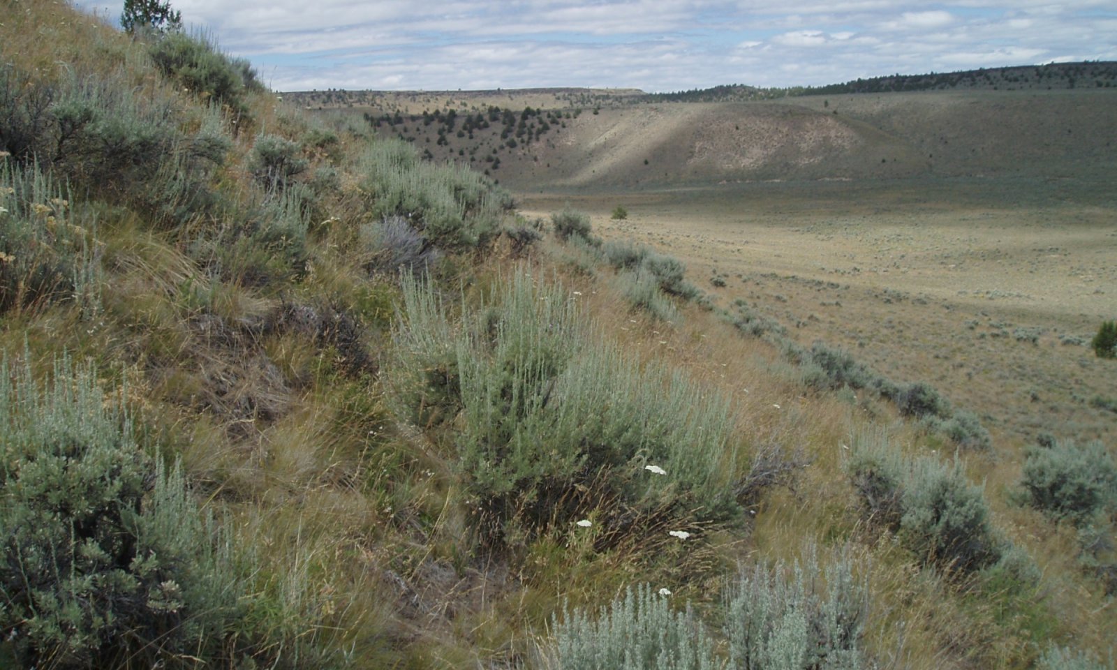
In reference condition, this ecological site supports a plant community dominated by Idaho fescue (Festuca idahoensis) and bluebunch wheatgrass (Pseudoroegneria spicata) with a shrub component of mountain big sagebrush (Artemisia tridentata ssp. vaseyana). Abiotically, this site is characterized by north aspects, moderately deep to deep soils and a frigid/xeric soil climate. Historically, plant community dynamics were driven primarily by disturbances such as periodic fire and drought. Presently, reference conditions are less common and current dynamics are influenced by the spread of invasive species, proliferation of western juniper (Juniperus occidentalis), livestock grazing pressures and fire suppression.
Associated sites
R010XB033OR JD Shallow North 12-16 PZ
Adjacent shallow north slopes
R010XB028OR JD Shrubby Mountain 12-16 PZ
Adjacent non-aspect positions with greater antelope bitterbrush cover
R010XB081OR Blue Mountain Foothills, Claypan North 12-16 PZ
Adjacent north aspects with root restricting claypan layers
Similar sites
R010XB033OR JD Shallow North 12-16 PZ
Shallow rather than moderately deep to deep soil
R010XB070OR JD North 12-16 PZ
JD sediments LRU, Mesic soil temperature regime, lower elevation range
R010XB071OR JD Shrubby Mountain North 12-16 PZ
Higher cover of antelope bitterbrush
R010XB081OR Blue Mountain Foothills, Claypan North 12-16 PZ
North aspects with root restricting claypan layers
Table 1. Dominant plant species
Tree Not specified
Shrub (1) Artemisia tridentata ssp. vaseyana
Herbaceous (1) Festuca idahoensis
(2) Pseudoroegneria spicata ssp. spicataPhysiographic features
This site occurs on northerly exposures composed of residuum and colluvium derived from hard igneous extrusive geologies (basalt, andesite, rhyolite, tuff, etc.) with an influence of volcanic ash in the surface. Slopes range from 12 to 60 percent. Elevation varies from 3,000 to 5,600 feet (900 to 1,700 meters). This site is not subject to ponding or flooding and no water table is present.
Table 2. Representative physiographic features
Landforms (1) Upland > Hill
(2) Upland > Mountain slope
Flooding frequency None Ponding frequency None Elevation 3000 – 5600 ft Slope 12 – 60 % Aspect W, NW, N, NE Climatic features
The annual precipitation is 12 to 16 inches (300 to 400 mm), most of which occurs in the form of snow during the months of November through March. Localized, occasionally severe, convectional storms occur during the summer. Frost free days are approximately 50 to 80. The soil temperature regime is frigid. The graphs below are populated from the closest available weather station to representative site locations and are provided to indicate general climate patterns.
Table 3 Representative climatic features
Frost-free period (characteristic range) 50-80 days Freeze-free period (characteristic range) Precipitation total (characteristic range) 10-20 in Frost-free period (average) 70 days Freeze-free period (average) Precipitation total (average) 10 in Characteristic rangeActual rangeBarLineFigure 1. Monthly precipitation range
Characteristic rangeActual rangeBarLineFigure 2. Monthly minimum temperature range
Characteristic rangeActual rangeBarLineFigure 3. Monthly maximum temperature range
BarLineFigure 4. Monthly average minimum and maximum temperature
Figure 5. Annual precipitation pattern
Figure 6 Annual average temperature pattern
Climate stations used
-
(1) BARNES STN [USC00350501], Prineville, OR
-
(2) MITCHELL 2 E [USC00355638], Mitchell, OR
">Influencing water features
This site is not influenced by water from a wetland or stream.
Wetland description
Not applicable
Soil features
The soils of this site are formed from residuum and colluvium derived from hard igneous extrusive geologies (basalt, andesite, rhyolite, tuff, etc.) with an influence of volcanic ash in the surface. They are moderately deep to deep. Typically the surface layer is an ashy loam or ashy loamy sand over a very gravelly loam or clay loam subsoil. Depth to bedrock is typically 20 to greater than 60 inches. Soil permeability is moderate. The available water holding capacity (AWC) is 2 to 6 inches.
Table 4. Representative soil features
Parent material (1) Colluvium – basalt
(2) Residuum – tuff
(3) Volcanic ash
Surface texture (1) Ashy loam
(2) Ashy loamy sand
(3) Cobbly loam
Family particle size (1) Ashy
(2) Clayey-skeletal
(3) Loamy-skeletal
Drainage class Moderately well drained to well drained Permeability class Moderate to slow Depth to restrictive layer 20 – 60 in Soil depth 20 – 60 in Surface fragment cover <=3" 5 – 20 % Surface fragment cover >3" 15 – 30 % Available water capacity
(0-40in)2 – 6 in Calcium carbonate equivalent
(0-40in)Not specified Electrical conductivity
(0-40in)0 – 2 mmhos/cm Sodium adsorption ratio
(0-40in)Not specified Soil reaction (1:1 water)
(0-40in)6.6 – 7.3 Subsurface fragment volume <=3"
(4-40in)15 – 50 % Subsurface fragment volume >3"
(4-40in)10 – 40 % Ecological dynamics
The reference plant community is dominated by Idaho fescue and bluebunch wheatgrass in the understory and mountain big sagebrush in the overstory. Sandberg bluegrass, prairie junegrass, squirreltail and a variety of forbs are also present.
Ecological Dynamics and Disturbance Response:
Ecological dynamics of this site are primarily driven by interactions between climatic patterns and disturbance regimes. Frequent low intensity fires were the historical disturbance that maintained the reference state and drove plant community shifts within the state. Intensity and frequency of these fires is strongly influence by drought cycles and insect or disease attacks on the plant community. Introduction of exotic annual grasses compromises the resistance and resiliency of the site, putting it at higher risk of crossing a threshold into another state.
Periodic drought regularly influences sagebrush ecosystems and drought duration and severity has increased throughout the 20th century in much of the Intermountain West. Major shifts away from historical precipitation patterns have the greatest potential to alter ecosystem function and productivity. Species composition and productivity can be altered by the timing of precipitation and water availability with the soil profile (Bates et al. 2006).
The Great Basin sagebrush communities have high spatial and temporal variability in precipitation both among years and within growing seasons. Nutrient availability is typically low but increases with elevation and closely follows moisture availability. The invasibility of plant communities is often linked to resource availability. Disturbance can decrease resource uptake due to damage or mortality of the native species and depressed competition or can increase resource pools by the decomposition of dead plant material following disturbance. The invasion of sagebrush communities by cheatgrass (Bromus tectorum) has been linked to disturbances (fire, abusive grazing) that have resulted in fluctuations in resources (Chambers et al. 2007).
The range and density of western juniper has increased since the middle of the nineteenth century (Tausch 1999, Miller and Tausch 2000). Causes for expansion of western juniper into sagebrush ecosystems include wildfire suppression, historic livestock grazing, and climate change (Bunting 1994). Mean fire return intervals prior to European settlement in mountain big sagebrush ecosystems were 15 to 25 years (Burkhardt and Tisdale 1976, Young and Evans 1981), frequent enough to inhibit the encroachment of western juniper into these big sagebrush cover types (Miller and Tausch 2000). With the increased suppression of wildfire and livestock grazing, which reduces ground fuels and understory competition, regeneration and establishment of western juniper have expanded into suitable sites previously dominated by big sagebrush (Burns and Honkala 1990). An increase in crown density causes a decrease in understory perennial vegetation and an increase in bare ground. This allows for the invasion of non-native annual species such as cheatgrass (Bromus tectorum) and medusahead (Taeniatherum caput-medusae). With annual species in the understory wildfire can become more frequent and increase in intensity. With frequent wildfires these plant communities can convert to annual species with a sprouting shrub and juvenile tree overstory.
Treatment Response:
North facing aspects respond positively to juniper removal if soil erosion is not significant. Seeding may be necessary if there is less than one to two bunchgrass plants per meter square in the understory. Sagebrush and forbs may also need to be seeded if adult plants are no longer present in the understory.
Adapted from: Stringham, et al. 2017State and transition model
More interactive model formats are also available. View Interactive Models
Click on state and transition labels to scroll to the respective textStates 2 and 5 (additional transitions)
T1A - Introduction of non-native species T2A - Less frequent fire or extended drought reduces perennial bunchgrasses and allows for an increase in shrub and tree species T2B - Catastrophic fire, often coupled with soil disturbing activities or extended drought. T2C - Time and lack of disturbance allows for maturation of the tree community T3A - Catastrophic fire, multiple fires, or soil disturbing treatments or activities. T3B - Time and lack of disturbance allows for maturation of the tree community. R5A - Mechanical treatment of trees coupled with seeding of desired species. R5B - Mechanical treatment of trees T5A - Catastrophic fire State 1 submodel, plant communities
1.1A - Low and high severity fire 1.1B - Time and lack of disturbance 1.2A - Time and lack of disturbance 1.3A - High severity fire 1.3B - Low severity fire State 2 submodel, plant communities
2.1A - Low and high severity fire, brush treatments, or tree thinning 2.1B - Time and lack of disturbance 2.2A - Time and lack of disturbance 2.3A - Moderate to high severity fire, brush treatments and tree thinning 2.3B - Low severity fire, brush treatments and tree thinning State 3 submodel, plant communities
3.1A - Fire or brush treatments with minimal soil disturbance. 3.2A - Time and lack of disturbance State 4 submodel, plant communities
4.1A - Fire 4.2A - Time and lack of disturbance State 5 submodel, plant communities
5.1A - Time and lack of disturbance State 1
Historic Reference
The Reference State 1.0 is a representation of the natural range of variability under pristine conditions. The reference state has 3 general community phases; a shrub-grass dominant phase, a perennial grass dominant phase and a shrub dominant phase. State dynamics are maintained by interactions between climatic patterns and disturbance regimes. Negative feedbacks enhance ecosystem resilience and contribute to the stability of the state. These include the presence of all structural and functional groups, low fine fuel loads, and retention of organic matter and nutrients. Plant community phase changes are primarily driven by fire, periodic drought and/or insect or disease attack. Negative feedbacks enhance ecosystem resilience and contribute to the stability of the state. These feedbacks include the presence of all structural and functional groups, low fine fuel loads, and retention of organic matter and nutrients.
Dominant plant species
-
mountain big sagebrush (Artemisia tridentata ssp. vaseyana), shrub
-
Idaho fescue (Festuca idahoensis), grass
-
bluebunch wheatgrass (Pseudoroegneria spicata ssp. spicata), grass
Community 1.1
Reference CommunityMountain Big Sagebrush - Idaho Fescue
Deep-rooted perennial bunchgrasses and sagebrush are dominant, with a diverse forb component present. Annual non-native species present.Dominant plant species
-
mountain big sagebrush (Artemisia tridentata ssp. vaseyana), shrub
-
Idaho fescue (Festuca idahoensis), grass
Figure 7. Annual production by plant type (representative values) or group (midpoint values)
Table 5. Annual production by plant type
Plant type Low
(lb/acre)Representative value
(lb/acre)High
(lb/acre)Grass/Grasslike 740 905 1150 Shrub/Vine 95 115 145 Forb 50 60 80 Tree 15 20 25 Total 900 1100 1400 Table 6. Ground cover
Tree foliar cover 0-0% Shrub/vine/liana foliar cover 10-10% Grass/grasslike foliar cover 50-60% Forb foliar cover 0-10% Non-vascular plants 30-40% Biological crusts 0% Litter 10-10% Surface fragments >0.25" and <=3" 0-10% Surface fragments >3" 0-10% Bedrock 0% Water 0% Bare ground 0-0% Figure 8. Plant community growth curve (percent production by month). OR4181 , B10 JD higher elev. RPC. B10XB JD higher elev. 12-16 PZ RPC.
Jan Feb Mar Apr May Jun Jul Aug Sep Oct Nov Dec J F M A M J J A S O N D 0 0 0 10 25 25 20 10 5 5 0 0 Community 1.2
Perennial Bunchgrasses DominantDeep-rooted perennial bunchgrasses are dominant and forbs may increase.
Community 1.3
Sagebrush DominantSagebrush increases while the deep-rooted perennial bunchgrasses decrease and young juniper increase.
Pathway 1.1A
Community 1.1 to 1.2Low severity fire creates a grass and sagebrush mosaic; high severity fire significantly reduces sagebrush cover and leads to a community dominated by grasses and forbs.
Pathway 1.1B
Community 1.1 to 1.3Time and lack of disturbance such as fire facilitates an increase in the shrub overstory.
Pathway 1.2A
Community 1.2 to 1.1Time and lack of disturbance allows for shrub regeneration.
Pathway 1.3A
Community 1.3 to 1.1High severity fire significantly reduces sagebrush and juniper cover and leads to a community dominated by grasses and forbs.
Pathway 1.3B
Community 1.3 to 1.2Low severity fire reduces sagebrush and juniper cover and creates a sagebrush and grass mosaic.
State 2
Current PotentialThis state is similar to the Reference State 1.0 with three similar community phases. Ecological function has not changed, however the resiliency of the state has been reduced by the presence of invasive weeds. Non-natives may increase in abundance but will not become dominant within this State. These non-natives can be highly flammable and can promote fire where historically fire had been infrequent. Negative feedbacks enhance ecosystem resilience and contribute to the stability of the state. These feedbacks include the presence of all structural and functional groups, low fine fuel loads, and retention of organic matter and nutrients. Positive feedbacks decrease ecosystem resilience and stability of the state. These include the non-natives’ high seed output, persistent seed bank, rapid growth rate, residual dry matter accumulation, and adaptations for seed dispersal.
Dominant plant species
-
mountain big sagebrush (Artemisia tridentata ssp. vaseyana), shrub
-
Idaho fescue (Festuca idahoensis), grass
-
bluebunch wheatgrass (Pseudoroegneria spicata ssp. spicata), grass
Community 2.1
Bunchgrasses/SagebrushDeep-rooted perennial bunchgrasses and sagebrush are dominant, with a diverse forb component present. Annual non-native species are present.
Community 2.2
Perennial Bunchgrasses/AnnualsDeep-rooted perennial bunchgrasses are dominant with annual non-native species present to increase. Forbs may increase.
Community 2.3
Sagebrush/AnnualsSagebrush increases while the deep-rooted perennial bunchgrasses decrease. The young juniper are increasing and the non-native annual species are present and increasing.
Pathway 2.1A
Community 2.1 to 2.2Low severity fire creates a grass and sagebrush mosaic; high severity fire significantly reduces sagebrush cover and leads to a community dominated by grasses and forbs. Brush treatments and tree thinning would also reduce the overstory allowing the perennial understory to increase.
Pathway 2.1B
Community 2.1 to 2.3Time and lack of disturbance such as fire facilitates an increase in the shrub overstory; may be coupled with drought.
Pathway 2.2A
Community 2.2 to 2.1Time and lack of disturbance allows for shrub regeneration.
Pathway 2.3A
Community 2.3 to 2.1Moderate to high severity fire reduces sagebrush and juniper cover and leaves a community dominated by grasses and forbs. Brush treatments and tree thinning would also reduce the overstory allowing the perennial understory to increase.
Pathway 2.3B
Community 2.3 to 2.2Low severity fire creates a sagebrush and grass mosaic. Brush treatments and tree thinning would also reduce the overstory allowing the perennial understory to increase.
State 3
Shrub
This state is a product of many years of heavy grazing during time periods harmful to perennial bunchgrasses, changes in the historic fire regime or long-term drought favoring shrub establishment. Grazing tolerant Sandberg bluegrass will increase with a reduction in deep rooted perennial bunchgrass competition and become the dominant grass. Sagebrush dominates the overstory and rabbitbrush may be a significant component. Sagebrush cover exceeds site concept and may be decadent, reflecting stand maturity and lack of seedling establishment due to competition with mature plants. The shrub overstory and Sandberg bluegrass understory dominate site resources such that soil water, nutrient capture, nutrient cycling and soil organic matter are temporally and spatially redistributed (3.1). In both community phases, bare ground may be significant with soil redistribution occurring between interspace and shrub locations. Western juniper increases and may begin to influence the understory vegetation.
Dominant plant species
-
mountain big sagebrush (Artemisia tridentata ssp. vaseyana), shrub
-
antelope bitterbrush (Purshia tridentata), shrub
-
rabbitbrush (Chrysothamnus), shrub
-
rubber rabbitbrush (Ericameria nauseosa), shrub
-
Sandberg bluegrass (Poa secunda), grass
Community 3.1
Sagebrush/Bluegrass/AnnualsSagebrush is dominant and Sandberg bluegrass is increasing. The deep-rooted perennial bunchgrasses are a minor component or are missing. Non-native annual species are present and increasing. Western juniper is present to increasing.
Community 3.2
Bluegrass/Sagebrush/AnnualsSandberg bluegrass is dominant with sagebrush decreasing. Deep-rooted perennial grasses are a minor component or missing. Non-native annual species are present to increasing. Western juniper is present to increasing.
Pathway 3.1A
Community 3.1 to 3.2Fire or brush treatments with minimal soil disturbance.
Pathway 3.2A
Community 3.2 to 3.1Time and lack of disturbance allows for sagebrush to recover. Western juniper may increase.
State 4
AnnualThis community is characterized by the dominance of annual non-native species such as cheatgrass, medusahead, and tansy mustard in the understory. Sagebrush and rabbitbrush may dominate the overstory.
Dominant plant species
-
cheatgrass (Bromus tectorum), grass
-
medusahead (Taeniatherum caput-medusae), grass
-
North Africa grass (Ventenata dubia), grass
Community 4.1
Shrubs/AnnualsSagebrush and rabbitbrush is dominant in the community with annual non-native species dominant in the understory. Mat forming forbs increase and Western juniper present to increasing.
Community 4.2
AnnualsAnnual non-native species are dominant once the perennial grasses decrease. Western juniper may be present. Rabbitbrush and other sprouting shrubs may increase.
Pathway 4.1A
Community 4.1 to 4.2Fire
Pathway 4.2A
Community 4.2 to 4.1Time and lack of disturbance allows for sagebrush and sprouting shrubs to increase. Western juniper may be present.
State 5
Tree
This state is characterized by a dominance of western juniper in the overstory. Sagebrush and perennial bunchgrasses may still be present, but they are no longer controlling site resources. Soil moisture, soil nutrients and soil organic matter distribution and cycling have been spatially and temporally altered.
Dominant plant species
-
western juniper (Juniperus occidentalis), tree
Community 5.1
Juniper/SagebrushWestern juniper becomes dominant as sagebrush decreases. Deep-rooted perennial grasses decrease and Sandberg bluegrass may increase. Non-native annual species increase.
Community 5.2
Juniper WoodlandWestern juniper is dominant with only a minor component of sagebrush. Deep-rooted perennial grasses are also a minor component or may be missing. Non-native annual species increase and the bare ground may be increasing.
Pathway 5.1A
Community 5.1 to 5.2Time and lack of disturbance allows for maturation of the tree community.
Transition T1A
State 1 to 2Introduction of non-native species
Transition T2A
State 2 to 3Less frequent fire or extended drought reduces perennial bunchgrasses and allows for an increase in shrub and tree species
Transition T2B
State 2 to 4Catastrophic fire, often coupled with soil disturbing activities or extended drought.
Transition T2C
State 2 to 5Time and lack of disturbance allows for maturation of the tree community
Transition T3A
State 3 to 4Catastrophic fire, multiple fires, or soil disturbing treatments or activities.
Transition T3B
State 3 to 5
Shrub
TreeTime and lack of disturbance allows for maturation of the tree community.
Restoration pathway R5A
State 5 to 2Mechanical treatment of trees coupled with seeding of desired species.
Restoration pathway R5B
State 5 to 3
Tree
ShrubMechanical treatment of trees
Transition T5A
State 5 to 4Catastrophic fire
Additional community tables
Table 7. Community 1.1 plant community composition
Group Common name Symbol Scientific name Annual production () Foliar cover (%) Grass/Grasslike1 Dominant Mid Bunch Grass 450–680 Idaho fescue FEID Festuca idahoensis 550–660 – 2 Subdominant Mid Bunchgrass 230–440 bluebunch wheatgrass PSSP6 Pseudoroegneria spicata 330–440 – 3 Short bunchgrass 20–25 Sandberg bluegrass POSE Poa secunda 20–25 – 4 Other Grasses 11–33 squirreltail ELEL5 Elymus elymoides 0–11 – prairie Junegrass KOMA Koeleria macrantha 0–11 – Shrub/Vine5 Shrubs 55–187 mountain big sagebrush ARTRV Artemisia tridentata ssp. vaseyana 55–165 – antelope bitterbrush PUTR2 Purshia tridentata 0–22 – 8 Other Shrubs 0–33 yellow rabbitbrush CHVI8 Chrysothamnus viscidiflorus 0–11 – rubber rabbitbrush ERNA10 Ericameria nauseosa 0–11 – tetraclea TETRA Tetraclea 0–11 – wax currant RICE Ribes cereum 0–11 – desert gooseberry RIVE Ribes velutinum 0–11 – Forb7 Dominant perennial forbs 22–66 buckwheat ERIOG Eriogonum 11–33 – lupine LUPIN Lupinus 11–33 – 9 Other perennial forbs 0–55 erigenia ERIGE Erigenia 0–11 – desertparsley LOMAT Lomatium 0–11 – common yarrow ACMI2 Achillea millefolium 0–11 – castilla CASTI Castilla 0–11 – pussytoes ANTEN Antennaria 0–11 – ragwort SENEC Senecio 0–11 – milkvetch ASTRA Astragalus 0–11 – sagebrush mariposa lily CAMA5 Calochortus macrocarpus 0–11 – Tree17 Juniper 11–33 western juniper JUOC Juniperus occidentalis 11–33 – Table 8. Community 1.2 plant community composition
Group Common name Symbol Scientific name Annual production () Foliar cover (%) Table 9. Community 1.3 plant community composition
Group Common name Symbol Scientific name Annual production () Foliar cover (%) Table 10. Community 2.1 plant community composition
Group Common name Symbol Scientific name Annual production () Foliar cover (%) Table 11. Community 2.2 plant community composition
Group Common name Symbol Scientific name Annual production () Foliar cover (%) Table 12. Community 2.3 plant community composition
Group Common name Symbol Scientific name Annual production () Foliar cover (%) Table 13. Community 3.1 plant community composition
Group Common name Symbol Scientific name Annual production () Foliar cover (%) Table 14. Community 3.2 plant community composition
Group Common name Symbol Scientific name Annual production () Foliar cover (%) Table 15. Community 4.1 plant community composition
Group Common name Symbol Scientific name Annual production () Foliar cover (%) Table 16. Community 4.2 plant community composition
Group Common name Symbol Scientific name Annual production () Foliar cover (%) Table 17. Community 5.1 plant community composition
Group Common name Symbol Scientific name Annual production () Foliar cover (%) Table 18. Community 5.2 plant community composition
Group Common name Symbol Scientific name Annual production () Foliar cover (%) Interpretations
Supporting information
References
-
Bates, J.D., T. Svejcar, R.F. Miller, and R.A. Angell. 2006. The effects of precipitation timing on sagebrush steppe vegetation. Journal of Arid Environments 64:670–697.
-
Bunting, S.C., B.M. Kilgore, and C.L. Bushey. 1987. Guidelines for Prescribe burning sagebrush-grass rangelands in the Northern Great Basin. General Technical Report INT-231. USDA Forest Service Intermountain Research Station, Ogden, UT. 33.
-
Burns, R.M. and B.H. Honkala. 1990. Silvics of North America. Volume 2: Hardwoods. Agriculture Handbook 654. U.S. Department of Agriculture, Forest Service.
-
Chambers, J.C., B.A. Bradley, C.S. Brown, C. D’Antonio, M.J. Germino, J.B. Grace, S.P. Hardegree, R.F. Miller, and D.A. Pyke. 2013. Resilience to Stress and Disturbance, and Resistance to Bromus tectorum L. Invasion in Cold Desert Shrublands of Western North America. Ecosystems 17:360–375.
-
Young, J.A. and R.A. Evans. 1981. Demography and Fire History of a Western Juniper Stand. Journal of Range Management 34:501–506.
Other references
Burkhardt, J. W. and E. W. Tisdale. 1976. Causes of juniper invasion in southwestern Idaho. Ecology
57:472-484.
Miller, R. F. and R. J. Tausch. 2000. The role of fire in pinyon and juniper woodlands: a descriptive analysis. Pages 15-30 in Proceedings of the invasive species workshop: the role of fire in the control and spread of invasive species. Fire conference.
Stringham, T.K, D. Snyder, and A. Wartgow. 2017. Final Report for USFS Crooked River National Grassland State-and-Transition Models for Selected Disturbance Response Groups in Major Land Resource Area B10 Oregon. University of Nevada Reno, Nevada Agricultural Experiment Station Research Report RR-2017-01. 230 p.
Available at: http://www.cabnr.unr.edu/resources/MLRA.aspx
Tausch, R. J. 1999. Historic pinyon and juniper woodland development. Proceedings: ecology and management of pinyon–juniper communities within the Interior West. Ogden, UT, USA: US Department of Agriculture, Forest Service, Rocky Mountain Research Station, RMRS-P-9:12-19Contributors
Jenni Moffitt, general updates 2020
Stringham et al. 2017, ecological dynamics/S&T Model
Cici Brooks
Bob Gillaspy
Ed Petersen
JPR
Andrew Neary - table population and edits 2021Approval
Kirt Walstad, 4/01/2025
Rangeland health reference sheet
Interpreting Indicators of Rangeland Health is a qualitative assessment protocol used to determine ecosystem condition based on benchmark characteristics described in the Reference Sheet. A suite of 17 (or more) indicators are typically considered in an assessment. The ecological site(s) representative of an assessment location must be known prior to applying the protocol and must be verified based on soils and climate. Current plant community cannot be used to identify the ecological site.
Author(s)/participant(s) Contact for lead author Date 04/01/2025 Approved by Approval date Composition (Indicators 10 and 12) based on Annual Production Indicators
-
Number and extent of rills:
-
Presence of water flow patterns:
-
Number and height of erosional pedestals or terracettes:
-
Bare ground from Ecological Site Description or other studies (rock, litter, lichen, moss, plant canopy are not bare ground):
-
Number of gullies and erosion associated with gullies:
-
Extent of wind scoured, blowouts and/or depositional areas:
-
Amount of litter movement (describe size and distance expected to travel):
-
Soil surface (top few mm) resistance to erosion (stability values are averages - most sites will show a range of values):
-
Soil surface structure and SOM content (include type of structure and A-horizon color and thickness):
-
Effect of community phase composition (relative proportion of different functional groups) and spatial distribution on infiltration and runoff:
-
Presence and thickness of compaction layer (usually none; describe soil profile features which may be mistaken for compaction on this site):
-
Functional/Structural Groups (list in order of descending dominance by above-ground annual-production or live foliar cover using symbols: >>, >, = to indicate much greater than, greater than, and equal to):
Dominant:
Sub-dominant:
Other:
Additional:
-
Amount of plant mortality and decadence (include which functional groups are expected to show mortality or decadence):
-
Average percent litter cover (%) and depth ( in):
-
Expected annual annual-production (this is TOTAL above-ground annual-production, not just forage annual-production):
-
Potential invasive (including noxious) species (native and non-native). List species which BOTH characterize degraded states and have the potential to become a dominant or co-dominant species on the ecological site if their future establishment and growth is not actively controlled by management interventions. Species that become dominant for only one to several years (e.g., short-term response to drought or wildfire) are not invasive plants. Note that unlike other indicators, we are describing what is NOT expected in the reference state for the ecological site:
-
Perennial plant reproductive capability:
Print Options
Sections
Font
AAAAOther
PrintThe Ecosystem Dynamics Interpretive Tool is an information system framework developed by the USDA-ARS Jornada Experimental Range, USDA Natural Resources Conservation Service, and New Mexico State University.
Accessibility statement


