
Natural Resources
Conservation Service
Ecological site F006XA001WA
Cool Frigid Xeric Ashy Slopes
(Douglas-fir Cool Dry Grass)
Last updated: 4/01/2025
Accessed: 09/02/2026
-
Search


Major Land Resource Area or ecological site by name and/or ID.
PreviousSectionsNextGeneral information
Provisional. A provisional ecological site description has undergone quality control and quality assurance review. It contains a working state and transition model and enough information to identify the ecological site.
MLRA notes
Major Land Resource Area (MLRA): 006X–Cascade Mountains, Eastern Slope
Major Land Resource Area (MLRA): 006X–Cascade Mountains, Eastern Slope
Stretching from northern Washington to southern Oregon, MLRA6 encompasses the mountain slopes, foothills, elevated plateaus and valleys on the eastern slopes of the Cascade mountains. This MLRA is a transitional area between the Cascade Mountains to the west and the lower lying Columbia Basalt Plateau to the east. Situated in the rain shadow of the Cascade Crest, this MLRA receives less precipitation than portions of the cascades further west and greater precipitation than the basalt plateaus to the east. Geologically, the majority of the MLRA is dominated by Miocene volcanic rocks, while the northern portion is dominated by Pre-Cretaceous metamorphic rocks and the southern portion is blanketed with a thick mantle of ash and pumice from Mount Mazama. The soils in the MLRA dominantly have a mesic, frigid, or cryic soil temperature regime, a xeric soil moisture regime, and mixed or glassy mineralogy. They generally are moderately deep to very deep, well drained, and loamy or ashy. Biologically, the MLRA is dominated by coniferous forest, large expanses of which are dominated by ponderosa pine, Douglas-fir or lodgepole pine. Areas experiencing cooler and moister conditions include grand fir, white fir, and western larch while the highest elevations include pacific silver fir, subalpine fir and whitebark pine. Economically, timber harvest and recreation are important land uses in these forests. Historically, many of these forests would have experienced relatively frequent, low and mixed severity fire favoring the development of mature forests dominated by ponderosa pine or Douglas-fir. In the southern pumice plateau forests, less frequent, higher severity fire was common and promoted the growth of large expanses of lodgepole pine forests.LRU notes
Major Land Resource Area: 6 – Cascade Mountains, Eastern Slopes
Modal Land Resource Unit (LRU): Common Resource Area (CRA) 6.3 - Okanogan Pine / Fir Hills
This LRU occurs predominantly on slopes of hills and mountains. The soils are dominantly in the Andisols and Inceptisols taxonomic order, with some Mollisols . Soil parent materials are dominantly colluvium and residuum from igneous, sedimentary, and metamorphic rock, glacial outwash, and glacial till, with a mantle or mixture of volcanic ash in the upper part. Taxonomic soil climate is primarily a frigid temperature regime and xeric moisture regime with average annual precipitation of about 23 inches.
Other LRU'S where the site occurs:
CRA 6.2 - Pasayten / Sawtooth Highland
CRA 6.4 - Chelan Tephra Hills
CRA 6.5 - Chiwaukum Hills and LowlandsClassification relationships
Forest Service Plant Associations:
CDG131 (WEN); CD-G1-31 (OKAN) – Douglas-fir/pinegrass (PSME/CARU)
CDS655 (WEN) – Douglas-fir/bearberry/pinegrass (PSME/ARUV/CARU
CDS412 (WEN) – Douglas-fir/pachistima/pinegrass (PSME/PAMY/CARU)
CDS675 (WEN) – Douglas-fir/bitterbrush/pinegrass (PSME/PUTR/CARUAssociated sites
F006XA005WA Cool Frigid Xeric Mountain Slopes (Douglas-fir Cool Moderately Dry Shrub/Herb)
This site commonly has low huckleberry (VAMY) and other shrubs in the understory.
F006XD002WA Cool Frigid Xeric Ashy Slopes (Grand fir Cool Dry Grass)
Occurs on moister sites, generally associated in Chelan and northern Kittitas counties.
F006XA004WA Cold Cryic Xeric Mountain Slopes (Subalpine fir Cold Dry Shrub)
On colder sites.
Similar sites
F006XA005WA Cool Frigid Xeric Mountain Slopes (Douglas-fir Cool Moderately Dry Shrub/Herb)
This site commonly has low huckleberry (VAMY) and other shrubs in the understory.
F006XB001WA Frigid Xeric Mountain Slopes (Douglas-fir Moderately Dry Shrub/Herb)
A little dryer site.
Table 1. Dominant plant species
Tree (1) Pseudotsuga menziesii
Shrub Not specified
Herbaceous (1) Calamagrostis rubescens
Physiographic features
This ecological site occurs mainly on mountain back slopes, shoulders and foot slopes, and glacial outwash terraces. It is found between 1,400 feet and 6,500 feet in elevation on all aspects. Slope gradients generally range from 20 to 40 percent, but can be found on slopes up to 90 percent.
Table 2. Representative physiographic features
Landforms (1) Mountains > Mountain slope
(2) Foothills > Hillslope
(3) Outwash terrace
Flooding frequency None Ponding frequency None Elevation 1600 – 4500 ft Slope 20 – 40 % Water table depth 0 – 80 in Aspect W, NW, N, NE, E, SE, S, SW Table 3. Representative physiographic features (actual ranges)
Flooding frequency Not specified Ponding frequency Not specified Elevation 1400 – 6500 ft Slope 0 – 90 % Water table depth 30 – 80 in Climatic features
Mean Annual precipitation
Total Range: 15 – 45 inches
Central tendency: 20 – 25 inches
Mean Annual Air Temperature
Total Range: 2.5-9.7 C (36 to 49 F)
Central tendency: 5.2-7.0 C (41 to 45 F)
Frost-free period (days)
Total range: 75-135
Central tendency: 95-110Table 4 Representative climatic features
Frost-free period (characteristic range) 100-110 days Freeze-free period (characteristic range) 140 days Precipitation total (characteristic range) 20-30 in Frost-free period (actual range) 80-140 days Freeze-free period (actual range) 140 days Precipitation total (actual range) 20-50 in Frost-free period (average) Freeze-free period (average) 140 days Precipitation total (average) Characteristic rangeActual rangeBarLineFigure 1. Monthly precipitation range
Characteristic rangeActual rangeBarLineFigure 2. Monthly minimum temperature range
Characteristic rangeActual rangeBarLineFigure 3. Monthly maximum temperature range
BarLineFigure 4. Monthly average minimum and maximum temperature
Figure 5. Annual precipitation pattern
Figure 6 Annual average temperature pattern
Climate stations used
-
(1) MAZAMA [USC00455133], Mazama, WA
">Influencing water features
Soil features
This ecological site is associated with several soil mapunit components. The components are dominantly Andic and Vitrandic taxonomic subgroups of Dystroxerept and Haploxerept great groups, and Vitrixerands in the Andisol taxonomic order. Soils are dominantly moderately deep to very deep and have average available water capacity of about 4.6 inches (11. 7 cm) in the 0 to 40-inches (0-100 cm) depth range. Soil parent material is dominantly volcanic ash deposits over glacial till, glacial outwash, and colluvium and residuum from granitic, volcanic, metamorphic, and sedimentary rock.
Dominant Soil Series:
Brevco, Koepke, Louploup, Merkel, Molson, Nevine, Palmich, Radercreek, Ramparter, Wapal, Wilma
Parent Materials:
Kind – volcanic ash, glacial till, glacial outwash, colluvium, residuum
Origin – granitic, volcanic, metamorphic, and sedimentary rock
Figure 7. Map of soil mapunits with a major component linked to the Douglas-fir Cool Dry Grass Ecological Site
Table 5. Representative soil features
Surface texture (1) Ashy fine sandy loam
(2) Ashy sandy loam
Family particle size (1) Loamy-skeletal
(2) Ashy over loamy-skeletal
(3) Ashy over loamy
(4) Ashy-pumiceous
Drainage class Well drained Depth to restrictive layer 20 – 60 in Surface fragment cover <=3" 0 – 30 % Surface fragment cover >3" 0 – 25 % Available water capacity
(0-40in)1.2 – 8.9 in Soil reaction (1:1 water)
(0-10in)6.1 – 7.3 Subsurface fragment volume <=3"
(Depth not specified)5 – 55 % Subsurface fragment volume >3"
(Depth not specified)0 – 60 % Table 6. Representative soil features (actual values)
Drainage class Moderately well drained to somewhat excessively drained Depth to restrictive layer 0 in Surface fragment cover <=3" 0 – 30 % Surface fragment cover >3" 0 – 25 % Available water capacity
(0-40in)1.2 – 8.9 in Soil reaction (1:1 water)
(0-10in)6.1 – 7.3 Subsurface fragment volume <=3"
(Depth not specified)5 – 55 % Subsurface fragment volume >3"
(Depth not specified)0 – 60 % Ecological dynamics
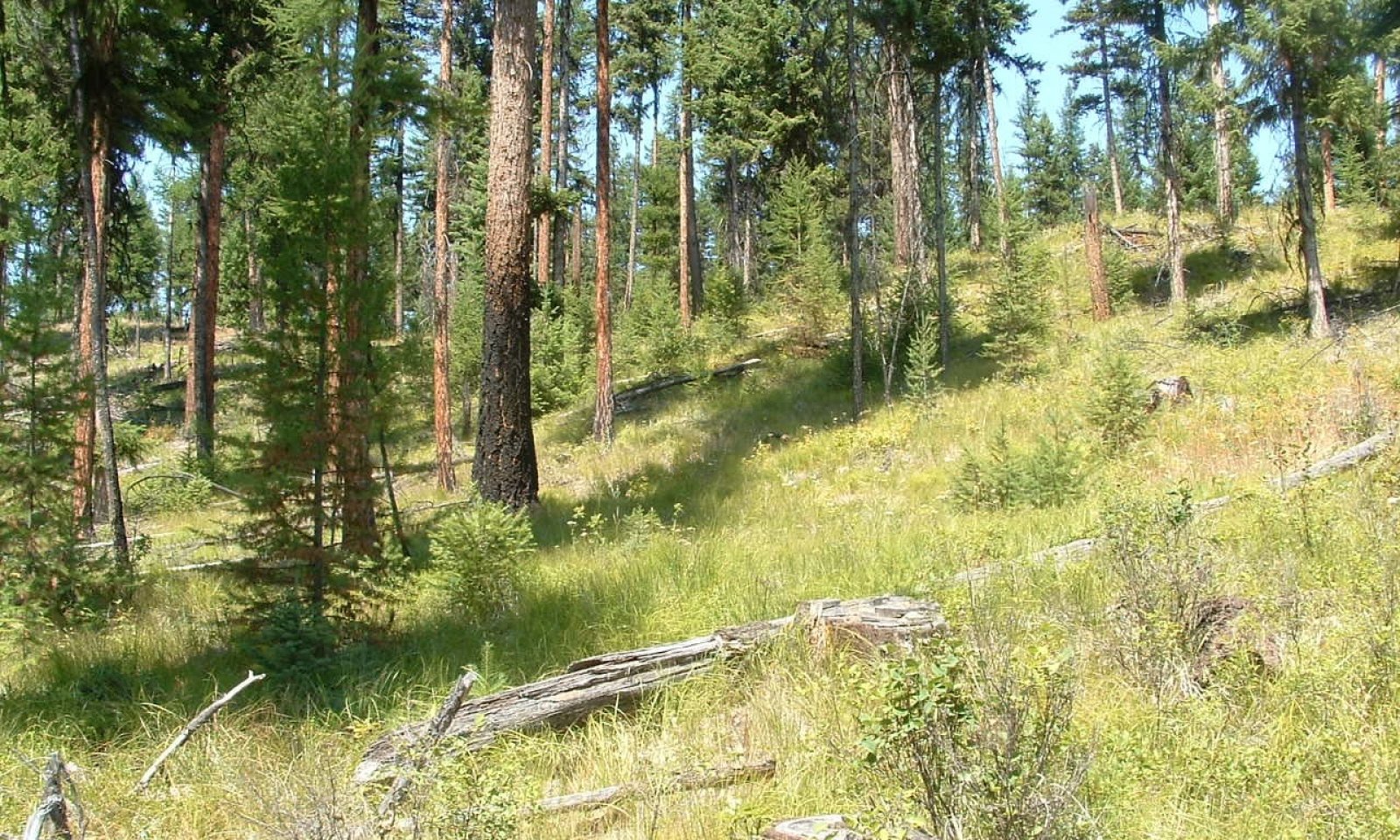
Open park-like stands of large diameter Douglas-fir, western larch and ponderosa pine with a pinegrass dominated understory. Frequent low severity ground fires every 10-20 years kept understory natural tree establishment low and maintained pinegrass cover. Overstory tree composition depends on seed source and moisture conditions. Douglas-fir and western larch dominate stand composition with low percentages of ponderosa pine depending on site disturbance. On the warmer portions of this site at lower elevations ponderosa pine will be dominate with scattered Douglas-fir and western larch. This site occurs on southern exposures or ridgetops at higher elevations (4000 - 5000 feet) and on flats or outwash plains with cool air drainage at lower elevations. Most of the soils are granitic or glacial till with a volcanic ash cap. Lodgepole pine can be present in overstory and understory depending on seed source and cool air drainage conditions and fire occurrence. Fire exclusion has cause natural regeneration to advance from seedling to high density pole stands underneath the larger older trees creating ladder fuels and increased potential for stand replacing fire capable of causing mortality to the older large diameter overstory. Douglas-fir is susceptible to budworm and tussock moth defoliation during drought years. Dwarf mistletoe can be present in Douglas-fir and western larch.
This ecological site encompasses 4 Douglas-fir plant associations incorporated into the Douglas-fir Cool Dry Grass biophysical group:
Douglas-fir/pinegrass, Douglas-fir/bearberry/pinegrass, Douglas-fir/pachistima/pinegrass, and Douglas-fir/bitterbrush/pinegrass.
The most dominant is the Douglas-fir/pinegrass association. It is located north of Lake Chelan in CRA 6. This ecological site is based on this plant association. The Douglas-fir/bearberry/pinegrass association occurs in the west area of CRA 6.3 and eastern half of Lake Chelan in CRA 6.4. The Douglas-fir/pachistima/pinegrass association occurs in the southern area of CRA 6.3 just north of Lake Chelan. The Douglas-fir/bitterbrush/pinegrass association occurs in the western portion of CRA 6.3 in close proximity to the DF/bearberry/pinegrass association.
The main difference ecologically in these 4 plant associations is the occurrence and abundance of western larch and shrub species. In the DF/pinegrass and DF/bearberry/pinegrass associations western larch is common in the overstory and can regenerate after disturbance. In the DF/pachistima/pinegrass and DF/bitterbrush/pinegrass associations western larch is absent or minor. Ponderosa pine is common in all these plant associations. Another main difference is understory species abundance. In the DF/pinegrass association pinegrass dominates the coverage. The other 3 plant associations there is more abundance and coverage of shrubs with pinegrass.
These shrub/pinegrass associations were included in the DF Cool Dry Grass Ecological site as they are cooler than the DF/shrub/bluebunch wheatgrass associations and react similar to the main DF/pinegrass association in regards to disturbance, with the exception of western larch absence.State and transition model
Custom diagramStandard diagram
More interactive model formats are also available. View Interactive Models
More interactive model formats are also available. View Interactive Models
Click on state and transition labels to scroll to the respective textEcosystem states
State 1 submodel, plant communities
State 2 submodel, plant communities
State 3 submodel, plant communities
State 4 submodel, plant communities
State 1
ReferenceReference plant community phase consists of park-like stands of large diameter Douglas-fir, western larch, and ponderosa pine. Understory is dominated by a continual sward of pinegrass. Tree regeneration is scattered. Frequent ground fires every 10-15 years cause mortality in established seedlings/saplings, mainly Douglas-fir creating sites for new seedling establishment, and perpetuate the pinegrass understory. Fire severity is low as to not cause mortality to large diameter overstory. USFS habitat type and plant association publications recognize this site as Douglas-fir/pinegrass. Douglas-fir is the dominant tree species, however, with frequent fire western larch and ponderosa pine will dominate the larger overstory. In warmer areas, western larch is absent or occasionally found in openings, and ponderosa pine becomes the major species with Douglas-fir. Also, in these warmer areas shrubs such as bearberry, pachistma, spirea, serviceberry, snowberry, bitterbrush and ceanothus spp. are abundant.
Fire exclusion has caused of this site to have high density stocking of the second level overstory from regeneration growing into pole to mature stands. This ladder fuel site condition has high potential for stand replacing fire even killing the larger older overstory.
Major insects that can cause mortality are the fir engraver, western spruce budworm, and Douglas-fir beetle. The Douglas-fir tussock moth can also cause concern. Drought and dense stands developing from prolonged fire intervals enhance beetle attack and tree mortality. The western pine beetle and the mountain pine beetle can cause mortality in ponderosa pine. Dwarf mistletoe is a major concern in western larch causing major growth loss and mortality. It will also be found on Douglas-fir, ponderosa pine, and lodgepole pine. Dwarf mistletoe was found in over 40% of the acreages in the Eastern Cascades where Douglas fir was a major stand component. Again, dense stands underneath infected trees from prolonged fire intervals causes mistletoe to spread easier. Fuel loads and ladder fuels increase fire intensity as a result.
Other diseases include Annosum, laminated, and Armillaria root rots. These root rot diseases are enhanced through soil compaction and root damage though selective logging and road building.
Forage production estimates from NRCS Range 5 Plots in Okanogan County in DF/pinegrass sites are as follows based on overstory tree canopy. Forage production figures are in pounds/acre for all vegetation below 4.5 feet (grass, sedges, forbs, shrubs, tree regeneration):
Overstory tree canopy – Forage production
0 – 20% - 800 to 1200 lbs/ac
20 – 40% - 600 – 800 lbs/ac
40 – 70% - 400 – 600 lbs/ac
70+% 0 – 400 lbs/ac
The bulk of the grass production was pinegrass and Idaho fescue. Small percentages of sedge and bluebunch wheatgrass were recorded. The most prominent forbs were lupine, basalmroot, pussytoes, and hawkweed. Shrubs included currant, snowbrush ceanothus, spirea, snowberry, kinnikinnik, and rose spp. Tree regeneration included Douglas-fir and ponderosa pine.Dominant plant species
-
Douglas-fir (Pseudotsuga menziesii), tree
-
lodgepole pine (Pinus contorta), tree
-
western larch (Larix occidentalis), tree
-
kinnikinnick (Arctostaphylos uva-ursi), shrub
-
Oregon boxleaf (Paxistima myrsinites), shrub
-
white spirea (Spiraea betulifolia), shrub
-
russet buffaloberry (Shepherdia canadensis), shrub
-
snowbrush ceanothus (Ceanothus velutinus), shrub
-
Saskatoon serviceberry (Amelanchier alnifolia), shrub
-
Cascade barberry (Mahonia nervosa), shrub
-
common snowberry (Symphoricarpos albus), shrub
-
antelope bitterbrush (Purshia tridentata), shrub
-
bluejoint (Calamagrostis canadensis), grass
-
Ross' sedge (Carex rossii), grass
-
Geyer's sedge (Carex geyeri), grass
-
bluebunch wheatgrass (Pseudoroegneria spicata), grass
-
heartleaf arnica (Arnica cordifolia), other herbaceous
-
common yarrow (Achillea millefolium), other herbaceous
-
white hawkweed (Hieracium albiflorum), other herbaceous
-
silky lupine (Lupinus sericeus), other herbaceous
-
arrowleaf balsamroot (Balsamorhiza sagittata), other herbaceous
-
Scouler's woollyweed (Hieracium scouleri), other herbaceous
Community 1.1
Open Park-like
Park-like widely spaced 125+ year old overstory of Douglas-fir, western larch, and ponderosa pine with understory dominated with pinegrass. Tree regeneration scattered and sporadic. Frequent ground fires every 10-20 years cause tree regeneration to be low. Overstory tree species composition dependent on seed source and moisture spectrum of site. Cooler moister locations have more Douglas-fir and western larch. Ponderosa pine dominate drier locations and have an increased understory cover of kinnikinnik.
(Restoration to open overstory through tree removal and understory burning.)
Resilience management. 1.1A – Frequent low intensity ground fires maintain open stand and pinegrass understory
Community 1.2
Stand Replacement
Stand replacing fire creates a grass and potential shrub dominated site. Pinegrass will dominate the site and potentially snowbrush ceanothus shrub species can dominate in some areas where fire was severe. Severe fire damage to soil can cause ceonothus shrub fields for many years causing site to go to Alternative State 3. In low or mix severity fires natural regeneration will be sporadic depending on seed source and plant competition.
Community 1.3
Stem Exclusion
Natural regeneration growing to the pole stage can consist of Douglas-fir, western larch, and ponderosa pine. Lodgepole pine can also form dense stands depending on seed source and cool air drainage areas. Lack of sun on forest floor due to tree crown density understory is sparse with sprigs of pinegrass scattered. When tree canopy thins from competition, management, insects/disease, windthrow, and/or fire, pinegrass will rapidly increase in coverage.
Community 1.4
Understory Reinitiation
Overstory starts to thin out or gaps created by insect/disease mortality or windthrow allowing understory to develop. Snags and large woody present. Pinegrass and forbs increase and regeneration of Douglas-fir can occur.
Pathway 1.1B
Community 1.1 to 1.2
Open Park-like
Stand ReplacementStand replacement fire caused by weather patterns prolonging fire return interval allowing tree regeneration layer to grow into sapling/pole stands creating ladder fuels.
Pathway 1.2A
Community 1.2 to 1.3
Stand Replacement
Stem ExclusionTime, fire interval extended to allow regeneration to grow into pole stands.
Pathway 1.3B
Community 1.3 to 1.2
Stem Exclusion
Stand ReplacementStand replacing fire
Pathway 1.3A
Community 1.3 to 1.4
Stem Exclusion
Understory ReinitiationTime, low fire intensity, pole stands survive into mature stand, scattered mortality occurs from competition, insects, and disease.
Pathway 1.4A
Community 1.4 to 1.1
Understory Reinitiation
Open Park-likeTime, with mix severity and low severity fires opening up stand.
Pathway 1.4B
Community 1.4 to 1.2
Understory Reinitiation
Stand ReplacementStand replacing fire
State 2
Fire ExclusionSince European settlement the fire regime has changed greatly reducing frequent low intensity ground fires that kept these forests more open, with reduced tree density and more resilient to severe intensity fires. In addition, years of hygrading (harvesting largest best trees on site), overgrazing, prevalence of many roads which create fire breaks, and tree plantations has created a different forest structure. Dense multi-layered forests of Douglas-fir underneath larger old pine, fir and larch now exist. Dense stands of understory Douglas-fir can have over 1000 stems per acre. This creates extensive ladder fuel conditions which lead to the potential for stand replacing fires.
Community 2.1
Multi-Storied StandScattered overstory of large old Douglas-fir, western larch and ponderosa pine with dense stands of Douglas-fir underneath. This plant community is a risk of severe stand replacing fire capable of killing the larger old overstory. Intensive fuel load reduction is needed to open up sites in this condition followed by using prescribed fire.
State 3
ShrubfieldsCommunity 3.1
ShrubfieldsSevere stand replacing fire causing duff and organic matter to be destroyed negatively affecting soil fertility. Ceanothus species, especially shiny leaf ceanothus, dominates the site for 50+ years. This shrub species can grow in low nitrogen soils caused by intensive hot fires. Tree regeneration nonexistent to sporadic not capable to reclaiming site.
State 4
PasturelandCommunity 4.1
Pasture ConversionA portion this ecological site has been converted to pasture using introduced grasses like orchard grass. Restoration would include intensive site preparation and tree planting followed by prescribed fire in future when trees more resistant to fire damage.
Transition T1A
State 1 to 2Fire exclusion allowing regeneration to develop underneath old overstory.
Transition T1B
State 1 to 3Shrubfields caused by severe fire and soil degradation.
Transition T1C
State 1 to 4Forest converted to pastureland .
Restoration pathway R2A
State 2 to 1Time, intensive tree removal of second level DF stand followed by prescribed burning
Restoration pathway R3A
State 3 to 1Careful selection of sites to determine if tree planting success is warranted.
Restoration pathway R4A
State 4 to 1Intensive tree establishment practices followed by prescribed burning when trees more fire resistant.
Additional community tables
Table 7. Community 1.1 plant community composition
Group Common name Symbol Scientific name Annual production () Foliar cover (%) Table 8. Community 1.2 plant community composition
Group Common name Symbol Scientific name Annual production () Foliar cover (%) Table 9. Community 1.3 plant community composition
Group Common name Symbol Scientific name Annual production () Foliar cover (%) Table 10. Community 1.4 plant community composition
Group Common name Symbol Scientific name Annual production () Foliar cover (%) Table 11. Community 2.1 plant community composition
Group Common name Symbol Scientific name Annual production () Foliar cover (%) Table 12. Community 3.1 plant community composition
Group Common name Symbol Scientific name Annual production () Foliar cover (%) Table 13. Community 4.1 plant community composition
Group Common name Symbol Scientific name Annual production () Foliar cover (%) Interpretations
Table 14. Representative site productivity
Supporting information
Inventory data references
Relationship to Other Established Classifications: United States National Vegetation Classification (2008) - A3395 Douglas fir- P. Pine / Herbaceous Understory Central Rocky Mt. Forest & Woodland Alliance Washington Natural Heritage Program. Ecosystems of Washington State, A Guide to Identification, Rocchio and Crawford, 2015 - Northern Rocky Mt. Dry-Mesic Montane Mixed Conifer Forest (D. Fir – Pine) USDA NRCS Common Resource Areas. 6.3 Pine/fir Hills, 6.4 Chelan Tephra Hills Level III and IV Ecoregions of WA, US EPA, June 2010 – 77e Okanogan Pine-Fir Hills, 77f Chelan Tephra Hills This ecological site includes the following USDA Forest Service Plant Associations: PSME/CARU, PSME/ARUV/CARU, PSME/PAMY/CARU, and PSME/PUTR/CARU. Lillibridge et. al PNW GTR – 359, Oct. 1995
Other references
Forest Plant Associations of the Okanogan National Forest, R6-Ecol-132b-1983. Williams, Lillybridge. September, 1983
Forest Plant Associations of the Wenatchee National Forest, PNW-GTR-359. October 1995. Lillybridge et al.
NRCS Soil and Site Index data for MLRA B6 in form of excel spreadsheets.
SSURGO MLRA B6 Soil Component Forest Ecoclasses (Plant Associations)
MLRA 430 Ecological Site Douglas-fir Cool Dry Grass (Douglas-fir/pinegrass)Contributors
Gary Kuhn
Carri Gaines
Steve CampbellApproval
Kirt Walstad, 4/01/2025
Rangeland health reference sheet
Interpreting Indicators of Rangeland Health is a qualitative assessment protocol used to determine ecosystem condition based on benchmark characteristics described in the Reference Sheet. A suite of 17 (or more) indicators are typically considered in an assessment. The ecological site(s) representative of an assessment location must be known prior to applying the protocol and must be verified based on soils and climate. Current plant community cannot be used to identify the ecological site.
Author(s)/participant(s) Contact for lead author Date 04/01/2025 Approved by Approval date Composition (Indicators 10 and 12) based on Annual Production Indicators
-
Number and extent of rills:
-
Presence of water flow patterns:
-
Number and height of erosional pedestals or terracettes:
-
Bare ground from Ecological Site Description or other studies (rock, litter, lichen, moss, plant canopy are not bare ground):
-
Number of gullies and erosion associated with gullies:
-
Extent of wind scoured, blowouts and/or depositional areas:
-
Amount of litter movement (describe size and distance expected to travel):
-
Soil surface (top few mm) resistance to erosion (stability values are averages - most sites will show a range of values):
-
Soil surface structure and SOM content (include type of structure and A-horizon color and thickness):
-
Effect of community phase composition (relative proportion of different functional groups) and spatial distribution on infiltration and runoff:
-
Presence and thickness of compaction layer (usually none; describe soil profile features which may be mistaken for compaction on this site):
-
Functional/Structural Groups (list in order of descending dominance by above-ground annual-production or live foliar cover using symbols: >>, >, = to indicate much greater than, greater than, and equal to):
Dominant:
Sub-dominant:
Other:
Additional:
-
Amount of plant mortality and decadence (include which functional groups are expected to show mortality or decadence):
-
Average percent litter cover (%) and depth ( in):
-
Expected annual annual-production (this is TOTAL above-ground annual-production, not just forage annual-production):
-
Potential invasive (including noxious) species (native and non-native). List species which BOTH characterize degraded states and have the potential to become a dominant or co-dominant species on the ecological site if their future establishment and growth is not actively controlled by management interventions. Species that become dominant for only one to several years (e.g., short-term response to drought or wildfire) are not invasive plants. Note that unlike other indicators, we are describing what is NOT expected in the reference state for the ecological site:
-
Perennial plant reproductive capability:
Print Options
Sections
Font
AAAAOther
PrintThe Ecosystem Dynamics Interpretive Tool is an information system framework developed by the USDA-ARS Jornada Experimental Range, USDA Natural Resources Conservation Service, and New Mexico State University.
Accessibility statement


