Natural Resources
Conservation Service
Ecological site R003XN542WA
Southern Washington Cascades Subalpine Parkland
Last updated: 1/29/2025
Accessed: 09/14/2026
-
Search
Major Land Resource Area or ecological site by name and/or ID.
PreviousSectionsNextGeneral information
Provisional. A provisional ecological site description has undergone quality control and quality assurance review. It contains a working state and transition model and enough information to identify the ecological site.
MLRA notes
Major Land Resource Area (MLRA): 003X–Olympic and Cascade Mountains
Steep mountains and narrow to broad, gently sloping valleys characterize this region. A triple junction of two oceanic plates and one continental plate is directly offshore from Puget Sound. Subduction of the oceanic plates under the westerly and northwesterly moving continental plate contributes to volcanic activity in the Cascades. Movement between these plates has resulted in major earthquakes in this area in the past and the formation of large stratovolcanoes. The Cascade Mountains consist primarily of volcanic crystalline rocks with some associated metasedimentary rocks. The average annual precipitation ranges from 60 to 100 inches in much of the region and 30 to 60 inches on the east side of the Cascade Mountains.
The dominant soil orders in this MLRA are Andisols, Spodosols, and Inceptisols, with minor amounts of Entisols, and Histosols. The soils in the area dominantly have a frigid or cryic soil temperature regime and an udic soil moisture regime. They generally are shallow to very deep, well drained, ashy to medial, and loamy or sandy and occur on mountain slopes and ridges.Ecological site concept
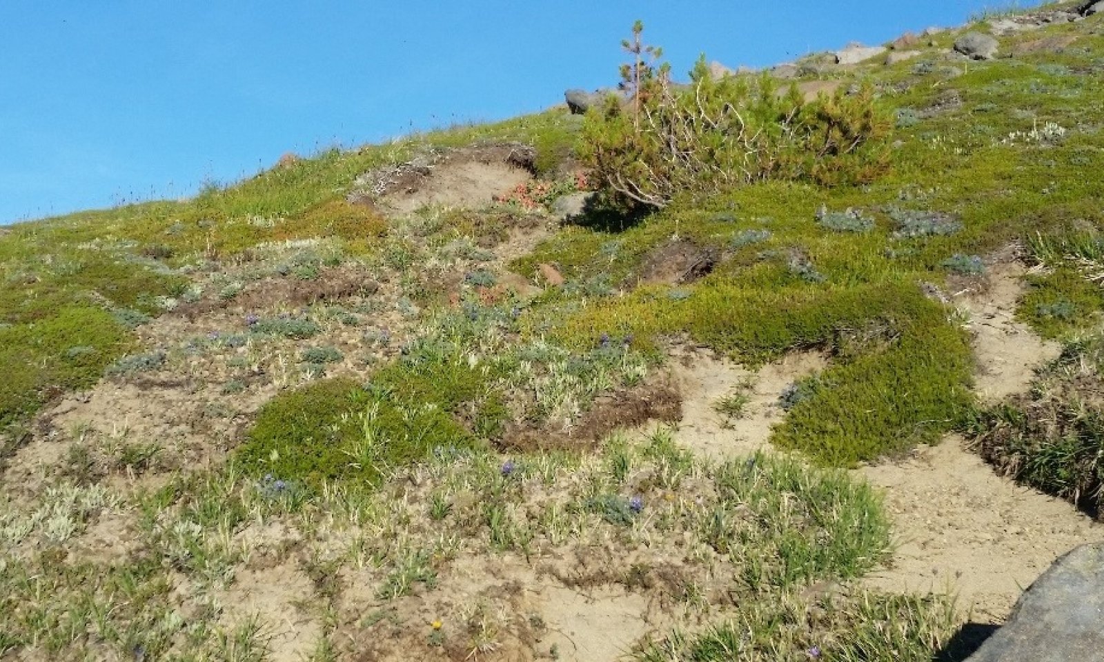
This ecological site is found in subalpine parklands at middle and high elevations of the Southern Washington Cascades. The site is predominantly comprised of low growing shrubs, forbs, grass, and grass-like species. This site is located on the north and east slopes of Mount Rainier, but occurs on all aspects within that zone. The primary factors that distinguish this ecological site are landscape position and climate.
This site is found on exposed ridges, glacial valley walls, and cirques and cirque floors that all experience high winds and reduced precipitation that limits soil moisture during the growing season and affects plant production and composition. Prevailing winds from the south and west result in a rain shadow that heavily influences this ecological site. The reduced summer precipitation and reduced cloud cover resulting from the rain shadow, in conjunction with the coarse soil texture, limit the amount of moisture available to plants during the growing season. Additionally, drying winds on exposed slopes and ridges add to the moisture deficient through increased evapotranspiration. These effects are most pronounced on the exposed south and west slopes and ridgetops. As a result, plants are more sparsely located on the landscape and primarily drought tolerant species.
Seasonal snowpack melts earlier on these sites and the lack of saturation in the soil profile allows soil to warm quickly with rising seasonal air temperature. Soils that support this ecological site occur in the cryic soil temperature regime and the udic soil moisture regime and are generally coarse textured, formed in volcanic ash and colluvium, and high in organic matter.
Common plants in the reference community include fescue (Festuca), mountain hairgrass (Vahlodea atropurpurea), smooth woodrush (Luzula glabrata), Sitka valerian (Valeriana sitchensis), false hellebore (Veratrum viride), American bistort (Polygonum bistortoides), arctic lupine (Lupinus arcticus), high mountain cinquefoil (Potentilla flabellifolia), subalpine fleabane (Erigeron peregrinus), Cascade desertparsley (Lomatium martindalei), spreading phlox (Phlox diffusa), and Cascade huckleberry (Vaccinium deliciosum).Associated sites
R003XN541WA Southern Washington Cascades Moist Subalpine Parkland
Ecological Site R003XN542WA, Southern Washington Cascades Subalpine Parkland, and Ecological Site R003XN541WA, Southern Washington Cascades Moist Subalpine Parkland are found within the same elevations. Both ecological sites are parkland ecosystems, however moisture availability plays a key role in distinguishing the Ecological Sites. Ecological Site R003XN542WA is more commonly found in rain shadow areas and, as a result, are drier and warmer habitats. Ecological Site R003XN541WA has higher soil moisture and able to support a more diverse vegetative ecosystem with a higher percentage of vegetative cover when compared to site R003XN542WA.
Table 1. Dominant plant species
Tree Not specified
Shrub (1) Vaccinium deliciosum
(2) Phyllodoce empetriformisHerbaceous (1) Phlox diffusa
(2) Lupinus arcticusPhysiographic features
This ecological site occurs across many landscape positions on ridges, swales on ridges, cirques, cirque floors, glacial-valley walls, and swales of glacial-valley walls in the Cascade Mountains (3,650-7,450 ft) in Mt. Rainier National Park. Although the ecological site may reach 7,450 feet in elevation, the site is most commonly found between 3,650 and 7,000 feet. The site is found on all slopes, however it is most commonly found between 10 to 40 percent slopes.
Table 2. Representative physiographic features
Landforms (1) Ridge
(2) Cirque
(3) Glacial-valley wall
Flooding frequency None Ponding frequency None Elevation 3650 – 7450 ft Slope 0 – 100 % Water table depth 10 – 0 in Aspect W, NW, N, NE, E, SE, S, SW Climatic features
This ecological site receives most of its annual precipitation from October to March. The mean annual precipitation ranges from 59 to 122 inches and the annual temperature ranges from 33 to 42 degrees Fahrenheit. Microclimate may vary depending on soil temperature and site specific features. Generally, this site occupies areas with cool, dry summers and cold, wet winters.
Table 3 Representative climatic features
Frost-free period (characteristic range) 30-60 days Freeze-free period (characteristic range) Precipitation total (characteristic range) 60-120 in BarLineFigure 1. Monthly precipitation range
BarLineFigure 2. Monthly minimum temperature range
">Influencing water features
This site is located in the middle to high elevations on the ridges, swales on ridges, cirques, cirque floors, swales on glacial valley-walls, and glacial-valley walls in Mount Rainier National Park. This site does not experience ponding or flooding. The water table will typically rise during the spring and summer months and recede in the fall.
Soil features
Applicable Soils: Burroughs, Chenuis, Littletahoma, Mountwow, Sarvant, Tatoosh
Applicable Soil Map Units within Mt. Rainier National Park: 8211, 8255, 8256, 8257, 9255, 9256, 9257, 9258, 9259
Soils that support this ecological site occur in the cryic soil temperature regime and the udic soil moisture regime. Soils representative of this ecological site vary in drainage and depth, however the over-riding factor for this ecological site is the position on the landscape and the amount of time and duration of snowpack and precipitation during the growing season. Burroughs, Chenuis, Littletahoma, Sarvant, and Tatoosh soils are well drained. Mountwow and Wahpenayo soils are somewhat poorly drained. Chenuis, Littletahoma, and Mountwow soils are very deep, Burroughs, Sarvant and Wahpenayo soils are moderately deep, and Tatoosh soils are shallow. These soils are found on ridges, cirques and glacial valley walls and are formed from volcanic ash and andesite colluvium, with or without andesite bedrock. Mountwow and Wahpenayo soils have a seasonally high water table between 10 and 20 inches of the surface at some point during the growing season. None of these soils have flooding or ponding potential. Chenuis and Sarvant soils have greater than 35 percent rock fragments in the control section, while all others do not. Soil textures are coarse, primarily medial sandy loams and medial loamy sands. These soils exhibit andic soil properties in all mineral horizons. Melanization is the dominant pedogenic process and podsolization is not evident in these profiles given the lack of coniferous forest cover. An umbric epipedon and cambic horizons are present in most soils. Thin organic horizons consisting of decomposing litter are present on the soil surface of the Mountwow, Burroughs and Chenuis soils, serving to protect the soil from wind and water erosion.Table 4. Representative soil features
Parent material (1) Volcanic ash
(2) Colluvium – andesite
(3) Residuum – andesite
Surface texture (1) Sandy loam
(2) Loamy sand
Drainage class Well drained to somewhat poorly drained Soil depth 18 – 60 in Surface fragment cover <=3" 0 – 70 % Surface fragment cover >3" 0 – 40 % Available water capacity
(Depth not specified)2.5 – 9 in Soil reaction (1:1 water)
(Depth not specified)4.5 – 5.5 Subsurface fragment volume <=3"
(Depth not specified)0 – 70 % Subsurface fragment volume >3"
(Depth not specified)0 – 50 % Ecological dynamics
This ecological site is found in subalpine parklands at middle and high elevations of the Southern Washington Cascades. It is located on the north and east slopes of Mount Rainier, but occurs on all aspects within that zone. Since this site is influenced by slope location, it is one of the earliest sites in the subalpine zone to start plant growth in the summer. Seasonal snowpack melts earlier on these sites and the lack of saturation in the soil profile allows soil to warm quickly with rising seasonal air temperature. Plant production is directly correlated to the snow release date which can be highly variable from year to year (Canaday, 1974). Soils that support this ecological site occur in the cryic soil temperature regime and the udic soil moisture regime. Generally, soils are coarse textured, formed in volcanic ash and colluvium, and high in organic matter.
Prevailing winds from the south and west result in a rain shadow that heavily influences this ecological site. The reduced summer precipitation and reduced cloud cover resulting from the rain shadow, in conjunction with the coarse soil texture, limit the amount of moisture available to plants during the growing season. Additionally, drying winds on exposed slopes and ridges add to the moisture deficient through increased evapotranspiration. These effects are most pronounced on the exposed south and west slopes and ridgetops.
The site is less susceptible to frequent natural disturbances, such as avalanches and soil movement. Historically, fire (anthropogenic and natural) was an important disturbance factor, suppressing the growth of encroaching conifers and retaining a forb, grass, and grass-like dominated parkland ecosystem (Hemstrom, 1982). This site is highly sensitive to small disturbances from soil compaction and damage to vegetation which may have significant impacts to the ecological integrity and resilience of the site. If there is a long period without disturbance, the site is subject to conifer encroachment including mountain hemlock (Tsuga mertensiana) and subalpine fir (Abies lasiocarpa) creating tree islands.
The reference community may be most common, but it is likely that all community phases occur as a matrix across the landscape. Common plants include fescue (Festuca), mountain hairgrass (Vahlodea atropurpurea), smooth woodrush (Luzula glabrata), Sitka valerian (Valeriana sitchensis), false hellebore (Veratrum viride), American bistort (Polygonum bistortoides), arctic lupine (Lupinus arcticus), high mountain cinquefoil (Potentilla flabellifolia), subalpine fleabane (Erigeron peregrinus), Cascade desertparsley (Lomatium martindalei), spreading phlox (Phlox diffusa), and Cascade huckleberry (Vaccinium deliciosum).State and transition model
Custom diagramStandard diagram
More interactive model formats are also available. View Interactive Models
Click on state and transition labels to scroll to the respective textState 1
ReferenceCommunity 1.1
Cascade Huckleberry, Pink Mountain Heather, Spreading Phlox, Arctic Lupine, Showy Sedge, and Fescue
Structure: subalpine parkland of shrubs, forbs, grass, and grass-like species
The reference community is a floristically rich mosaic of shrubs, forbs, and grass species that have been relatively undisturbed by natural and human influences. These subalpine ecosystems are located on aspects where snowmelt occurs in spring and early summer, providing for a longer growing season. Plant percent cover is variable but the reference community plants are common throughout the entire ecological site. Low-growing shrubs such as pink mountain-heather and Cascade huckleberry are most dominant, but white mountain heather and black huckleberry can be common and prolific in areas. Forbs including spreading phlox, American bistort, arctic lupine, and Sitka valerian cover the landscape with showy sedge interspersed.
Dwarfed species of mountain hemlock, subalpine fir, and Alaska cedar are scattered throughout the ecosystem, forming tree islands in places. Small natural disturbances such as frost heaving, wind blasting, and variation in snowpack can have small scale, but significant impacts on alpine vegetation. Soil compaction and damage to vegetation may have significant impacts on the ecological site integrity. Herbivores such as marmots, pikas, elk, migratory birds, and mountain goats will forage on the vegetation which may create patches of open ground (Martin, 2001).Dominant plant species
-
mountain hemlock (Tsuga mertensiana), tree
-
subalpine fir (Abies lasiocarpa), tree
-
Alaska cedar (Callitropsis nootkatensis), tree
-
Cascade bilberry (Vaccinium deliciosum), shrub
-
pink mountainheath (Phyllodoce empetriformis), shrub
-
thinleaf huckleberry (Vaccinium membranaceum), shrub
-
western moss heather (Cassiope mertensiana), shrub
-
showy sedge (Carex spectabilis), grass
-
arctic lupine (Lupinus arcticus), other herbaceous
-
Sitka valerian (Valeriana sitchensis), other herbaceous
-
American bistort (Polygonum bistortoides), other herbaceous
-
spreading phlox (Phlox diffusa), other herbaceous
Community 1.2
Mountain Hemlock, Subalpine Fir, and Cascade Huckleberry
Structure: tree islands
Community phase 1.2 represents a community stage of tree islands that are developed over long periods without disturbance. The establishment of conifers such as subalpine fir (Abies lasiocarpa) and mountain hemlock (Tsuga mertensiana) are successful and have developed pockets of mature trees. Common understory species include pink mountain heather, Sitka valerian, and Cascade huckleberry.Dominant plant species
-
mountain hemlock (Tsuga mertensiana), tree
-
subalpine fir (Abies lasiocarpa), tree
-
Alaska cedar (Callitropsis nootkatensis), tree
-
Cascade bilberry (Vaccinium deliciosum), shrub
-
pink mountainheath (Phyllodoce empetriformis), shrub
-
Sitka valerian (Valeriana sitchensis), other herbaceous
Community 1.3
Spreading Phlox, Showy Sedge, and FescueStructure: Grass/Forb Meadow
Early seral species of grasses and forbs are established following disturbance. Common plants such as arctic lupine, Sitka valerian, American bistort, Idaho fescue, and black sedge begin to dominate.Dominant plant species
-
showy sedge (Carex spectabilis), grass
-
fescue (Festuca), grass
-
Sitka valerian (Valeriana sitchensis), other herbaceous
-
American bistort (Polygonum bistortoides), other herbaceous
-
arctic lupine (Lupinus arcticus), other herbaceous
Pathway 1.1A
Community 1.1 to 1.2
Cascade Huckleberry, Pink Mountain Heather, Spreading Phlox, Arctic Lupine, Showy Sedge, and Fescue
Mountain Hemlock, Subalpine Fir, and Cascade HuckleberryThis pathway represents an ongoing lack of disturbance which favors the establishment of pockets of trees.
Pathway 1.1B
Community 1.1 to 1.3This pathway represents an extreme disturbance. The most typical disturbance is wildfire, however other extreme disturbances may include avalanche, landslide, or slower form of mass movement that removes the majority of the vegetation. Wildfire intensity will be elevation driven, and it is expected that lower elevations will be more devastated by higher intensity wildfires and the recovery time will be longer as a result.
Pathway 1.2A
Community 1.2 to 1.3This pathway represents an extreme disturbance. The most typical disturbance is wildfire, however other extreme disturbances may include avalanche, landslide, or slower form of mass movement that removes the majority of the vegetation. Wildfire intensity will be elevation driven, and it is expected that lower elevations will be more devastated by higher intensity wildfires and the recovery time will be longer as a result.
Pathway 1.3A
Community 1.3 to 1.1This pathway represents no further major disturbance and maturation of present species. Re-establishment of shrubs such as Cascade huckleberry and pink mountain heather occur as well as diversification of forb species.
Additional community tables
Table 5. Community 1.1 plant community composition
Group Common name Symbol Scientific name Annual production () Foliar cover (%) Table 6. Community 1.1 forest understory composition
Common name Symbol Scientific name Nativity Height (ft) Canopy cover (%) Grass/grass-like (Graminoids)smooth woodrush LUGL2 Luzula glabrata Native 1–12 0–50 showy sedge CASP5 Carex spectabilis Native 1–12 0–45 fescue FESTU Festuca Native 1–12 0–40 Forb/Herbarctic lupine LUAR2 Lupinus arcticus Native 1–12 0–50 Sitka valerian VASI Valeriana sitchensis Native 1–36 0–50 spreading phlox PHDI3 Phlox diffusa Native 1–4 0–20 green false hellebore VEVI Veratrum viride Native 1–48 0–15 American bistort POBI6 Polygonum bistortoides Native 1–36 0–10 subalpine fleabane ERPE3 Erigeron peregrinus Native 1–12 0–5 Shrub/Subshrubpink mountainheath PHEM Phyllodoce empetriformis Native 1–36 0–50 Cascade bilberry VADE Vaccinium deliciosum Native 1–16 0–40 thinleaf huckleberry VAME Vaccinium membranaceum Native 1–48 0–25 Table 7. Community 1.2 plant community composition
Group Common name Symbol Scientific name Annual production () Foliar cover (%) Table 8. Community 1.3 plant community composition
Group Common name Symbol Scientific name Annual production () Foliar cover (%) Interpretations
Supporting information
Inventory data references
Relationship to Other Established Classifications This ecological site falls within the National Vegetation Classification Group- North Pacific Alpine- Subalpine Dwarf-Shrubland and Heath This ecological site includes the following USDI National Park Service Associations Groups: CASMER-PHYEMP VACDEL-FESVIR
Type locality
Location 1: Pierce County, WA Township/Range/Section T17N R09E S16 Latitude 46° 57′ 26″ Longitude 121° 40′ 37″ Other references
Canaday, B.B., Fonda, R.W. 1974. The Influence of Subalpine Snowbanks on Vegetation Pattern, Production, and Phenology. Bulletin for Torrey Botanic Club, Vol 101 pp 340-350.
Crawford, R. C., C. B. Chappell, C. C. Thompson, and F. J. Rocchio. 2009. Vegetation Classification of Mount Rainier, North Cascades, and Olympic National Parks. Natural Resource Technical Report NPS/NCCN/NRTR-
Dwire, K. and Kauffman, J. 2003. Fire and Riparian Ecosystems in Landscapes in the Western United States. Forest Ecology and Management, Vol. 178 pg. 61-74.
Franklin, J.F., and Dyrness C.T. 1973. Natural Vegetation of Oregon and Washington. Oregon State University press, Corvallis, USA.
Douglas, G.W., and Bliss, L.C. 1972. Alpine and high subalpine plant communities of the western north cascades, Washington. Arctic and Alpine Research, Vol 4, No. 2, pp 147-166.
Hanley, D.P and D.M. Baumgartner. 2002. Forest Ecology in Washington. Washington State University Extension Publishing. Technical Report EB 1943.
Hanson, E.J., D.L. Azuma and B.A. Hiserote. 2002. Site Index Equations and Mean Annual Increment Equations for Pacific Northwest Research Station Forest Inventory and Analysis Inventories, 1985-2001. USDA Forest Service Pacific Northwest Research Station, Research Note PNW-RN-533.
Hemstrom, M., Franklin, J. 1982. Fire and Other Disturbances of the Forests in Mount Rainier National Park. Quaternary Research, Vol 18 pp 32-61.
Henderson, J.A., R.D. Lesher, D.H. Peter, and D.C. Shaw. 1992. Field Guide to the Forested Plant Associations of the Mt. Baker-Snoqualmie National Forest. USDA Forest Service Pacific Northwest Region Technical Paper R6-ECOL-TP-028-91.
Means, J.E. 1990. Tsuga mertensiana. Silvics of North America. [Online]. U.S. Department of Agriculture, Forest Service, Northeastern Area.
Martin, K. 2001. Wildlife in Alpine and Sub-alpine Habitats. Wildlife-Habitat Relationships in Oregon and Washington. Oregon State University Press. pp 285-310
Pojar J., and MacKinnon. 1994. Plants of the Pacific Northwest Coast. Lone Pine, Vancouver, British Columbia. 528 pages.
PRISM Climate Group, Oregon State University, http://prism.orgeonstate.edu, visited February, 2015.
Rochefort, R.M. and Peterson, D.L. 1996. Temporal and Spatial Distribution of Trees in Subalpine Meadows of Mount Rainier National Park. Arctic and Alpine Research, Vol. 28, No. 1 pp 52-59.
Seastedt, T.R., Adams, G.A. 2001. Effects of Mobile Tree Islands on Alpine Tundra Soils. Ecology, Vol 82 pp 8-17.
Scientia Silvica, 1997. Regeneration Patterns in the Mountain Hemlock Zone. Extension Series, No 6.
Smith, K., G. Kuhn, and L. Townsend. 2008. Culmination of Mean Annual Increment for Indicator Tree Species in the State of Washington. USDA-NRCS Technical Note Forestry-9.
Tesky, J.L. 1992. Tsuga mertensiana. In: Fire Effects Information System [Online]. U.S. Department of Agriculture, Forest Service, Rocky Mountain Research Station, Fire Sciences Laboratory.
Topik, C., N. M. Halverson, and D. G. Brockway. 1986. Plant Associations and Management Guide for the Western Hemlock Zone, Gifford Pinchot National Forest. USDA Forest Service Pacific Northwest Region Technical Paper R6-ECOL-230A-1986.
United States Department of Agriculture, Forest Service, 2015. Silvics Manual Vol 1. http://na.fs.fed.us/spfo/pubs/silvics_manual/Volume_1/vol1_Table_of_contents.htm, visited December 2015.
United States Department of Agriculture, Natural Resources Conservation Service, and United States Department of the Interior, National Park Service. 2014. Ecological Site Descriptions for North Cascades National Park Complex, Washington.
United States National Vegetation Classification. 2016. United States National Vegetation Classification Database, V2.0. Federal Geographic Data Committee, Vegetation Subcommittee, Washington DC. (accessed 28, November, 2016.
Washington Department of Natural Resources, Natural Heritage Program. 2015. Ecological Systems of Washington State. A Guide to Identification.Contributors
Erin Kreutz
Erik Dahlke
Philip Roberts
Marty ChaneyApproval
Kirt Walstad, 1/29/2025
Rangeland health reference sheet
Interpreting Indicators of Rangeland Health is a qualitative assessment protocol used to determine ecosystem condition based on benchmark characteristics described in the Reference Sheet. A suite of 17 (or more) indicators are typically considered in an assessment. The ecological site(s) representative of an assessment location must be known prior to applying the protocol and must be verified based on soils and climate. Current plant community cannot be used to identify the ecological site.
Author(s)/participant(s) Contact for lead author Date 05/10/2024 Approved by Approval date Composition (Indicators 10 and 12) based on Annual Production Indicators
-
Number and extent of rills:
-
Presence of water flow patterns:
-
Number and height of erosional pedestals or terracettes:
-
Bare ground from Ecological Site Description or other studies (rock, litter, lichen, moss, plant canopy are not bare ground):
-
Number of gullies and erosion associated with gullies:
-
Extent of wind scoured, blowouts and/or depositional areas:
-
Amount of litter movement (describe size and distance expected to travel):
-
Soil surface (top few mm) resistance to erosion (stability values are averages - most sites will show a range of values):
-
Soil surface structure and SOM content (include type of structure and A-horizon color and thickness):
-
Effect of community phase composition (relative proportion of different functional groups) and spatial distribution on infiltration and runoff:
-
Presence and thickness of compaction layer (usually none; describe soil profile features which may be mistaken for compaction on this site):
-
Functional/Structural Groups (list in order of descending dominance by above-ground annual-production or live foliar cover using symbols: >>, >, = to indicate much greater than, greater than, and equal to):
Dominant:
Sub-dominant:
Other:
Additional:
-
Amount of plant mortality and decadence (include which functional groups are expected to show mortality or decadence):
-
Average percent litter cover (%) and depth ( in):
-
Expected annual annual-production (this is TOTAL above-ground annual-production, not just forage annual-production):
-
Potential invasive (including noxious) species (native and non-native). List species which BOTH characterize degraded states and have the potential to become a dominant or co-dominant species on the ecological site if their future establishment and growth is not actively controlled by management interventions. Species that become dominant for only one to several years (e.g., short-term response to drought or wildfire) are not invasive plants. Note that unlike other indicators, we are describing what is NOT expected in the reference state for the ecological site:
-
Perennial plant reproductive capability:
Print Options
Sections
Font
AAAAOther
PrintThe Ecosystem Dynamics Interpretive Tool is an information system framework developed by the USDA-ARS Jornada Experimental Range, USDA Natural Resources Conservation Service, and New Mexico State University.
Accessibility statement