
Natural Resources
Conservation Service
Ecological site F003XN951WA
Southern Washington Cascades High Cryic Coniferous Forest
Last updated: 2/03/2025
Accessed: 09/16/2026
-
Search


Major Land Resource Area or ecological site by name and/or ID.
PreviousSectionsNextGeneral information
Provisional. A provisional ecological site description has undergone quality control and quality assurance review. It contains a working state and transition model and enough information to identify the ecological site.
MLRA notes
Major Land Resource Area (MLRA): 003X–Olympic and Cascade Mountains
Steep mountains and narrow to broad, gently sloping valleys characterize this MLRA. A triple junction of two oceanic plates and one continental plate is directly offshore from Puget Sound. Subduction of the oceanic plates under the westerly and northwesterly moving continental plate contributes to volcanic activity in the Cascade Mountains. Movement among these plates has resulted in major earthquakes and the formation of large stratovolcanoes. The Cascade Mountains consist primarily of volcanic crystalline rock and some associated metasedimentary rock. The mean annual precipitation is dominantly 60 to 100 inches, but it is 30 to 60 inches on the east side of the Cascade Mountains.
The soil orders in this MLRA are dominantly Andisols, Spodosols, and Inceptisols and minor areas of Entisols and Histosols. The soils are dominantly in the frigid or cryic temperature regime and the udic moisture regime. The soils generally are shallow to very deep, well drained, ashy to medial, and loamy or sandy. They are on mountain slopes and ridges.Ecological site concept
This ecological site is in cold, moist areas at high elevations (3,200 to 6,500 feet, or treeline) in Mount Rainier National Park. Elevation and climate are key components in the succession of the forest dynamics. The cold winters, deep snowpack, and mild summers impact the rate of growth and time to maturity. The fog and heavy cloud cover may provide necessary moisture in summer for areas along the timberline (Crawford, 2009).
The soils that support this ecological site are in the high cryic soil temperature regime and the udic soil moisture regime. They are moderately well drained or well drained. They are shallow to bedrock to very deep. Soil moisture is not a limiting factor to forest growth because of the abundance of precipitation and the inherent water-holding properties of soils influenced by volcanic ash. Slope and aspect are not defining features of the site.
The most common overstory species are mountain hemlock (Tsuga mertensiana) and subalpine fir (Abies lasiocarpa). Other common species include Pacific silver fir (Abies amabilis), noble fir (Abies procera), Alaska cedar (Callitropsis nootkatensis), and Engelmann spruce (Picea engelmannii).
Disturbance factors include forest pathogens, such as root rot, and high-intensity, low-frequency fires that are stand replacing. The frequency of fire is relatively low because of the extended periods of snowpack at the higher elevations.Associated sites
F003XN950WA Southern Washington Cascades Moist High Cryic Coniferous Forest
Ecological site F003XN951WA, Southern Washington Cascades High Cryic Coniferous Forest, is located within the same elevation as site F003XN950WA, Southern Washington Cascades Moist High Cryic Coniferous Forest. The dominant differentiating features are the depth to the water table and soil drainage class. The soils associated with site F003XN950WA have a higher water table during part of the growing season and are somewhat poorly drained. The vegetation on this site, such as Alaska cedar, Cascade azalea, and Sitka mountain ash, is suited to wetter environments. The soils associated with site F003XN951WA are moderately well drained or well drained soils. The vegetation on this site, such as subalpine fir and mountain heather, is more suited to drier conditions.
F003XN949WA Southern Washington Cascades High Cryic Riparian Forest
Ecological Site F003XN949WA, Southern Washington Cascades High Cryic Riparian Forest is located within the same elevation as site F003XN951WA, Southern Washington Cascades High Cryic Coniferous Forest. The sites are differentiated by disturbance regime and soil drainage. Ecological Site F003XN949WA is subject to flooding and vegetation is often less mature than site F003XN951WA. Vegetation within the riparian corridor is dominated by Alaska cedar, Sitka alder, and willows.
Similar sites
F003XN950WA Southern Washington Cascades Moist High Cryic Coniferous Forest
Ecological site F003XN951WA, Southern Washington Cascades High Cryic Coniferous Forest, is located within the same elevation as site F003XN950WA, Southern Washington Cascades Moist High Cryic Coniferous Forest. The dominant differentiating features are the depth to the water table and soil drainage class. The soils associated with site F003XN950WA have a higher water table during part of the growing season and are somewhat poorly drained. The vegetation on this site, such as Alaska cedar, Cascade azalea, and Sitka mountain ash, is suited to wetter environments. The soils associated with site F003XN951WA are moderately well drained or well drained soils. The vegetation on this site, such as subalpine fir and mountain heather, is more suited to drier conditions.
Table 1. Dominant plant species
Tree (1) Tsuga mertensiana
(2) Abies lasiocarpaShrub (1) Menziesia ferruginea
Herbaceous (1) Xerophyllum tenax
Physiographic features
This ecological site is on debris aprons of mountains slopes, glacial-valley walls, and ridges at the upper montane elevations (3,200 to 6,500 feet). The site is on all aspects and slopes, but it is dominantly on slopes of 15 to 65 percent. The site covers 24 percent of Mount Rainier National Park.
Table 2. Representative physiographic features
Landforms (1) Mountains > Mountain slope
(2) Mountains > Ridge
(3) Mountains > Glacial-valley wall
Climatic features
Most of the annual precipitation is received in October through April. The mean annual precipitation is 49 to 155 inches, and the mean annual air temperature is 30 to 45 degrees F. Generally, the summers are cool and dry summers and the winters are cold and wet.
Table 3 Representative climatic features
Frost-free period (characteristic range) 30-60 days Freeze-free period (characteristic range) Precipitation total (characteristic range) 50-160 in BarLineFigure 1. Monthly precipitation range
BarLineFigure 2. Monthly minimum temperature range
">Influencing water features
Generally, this ecological site is not influenced by wetland or riparian water features. It is not subject to flooding or ponding. The Unicornpeak soils have a seasonal high water table at a depth of 19 to 40 inches some time during the growing season. The water table typically rises in spring and recedes in fall.
Soil features
Applicable soils: Tipsoo, Unicornpeak, Owyhigh, Ipsut, Glacierisland, Sheepskull, Sluiskin
Applicable soil map units in Mount Rainier National Park: 8201, 8203, 8210, 8211, 8220, 8225, 8230, 8250, 8251, 8252, 8255, 8256, 8257, 9200, 9201, 9210, 9220, 9225, 9252, 9253, 9254, 9258, 9259, 9993, 9994
The Tipsoo, Unicornpeak, Owyhigh, and Ipsut soils are in the more stable landscape positions, and they formed in volcanic ash and colluvium derived from andesite. The Glacierisland, Sheepskull, and Sluiskin soils are on young, active geomorphic surfaces, and they formed in till, colluvium, and lahar deposits. The Tipsoo, Unicornpeak, and Glacierisland soils are deep or very deep, the Owyhigh and Sheepskull soils are moderately deep, and the Ipsut and Sluiskin soils are shallow.
The soils in the more stable positions have a mantle of volcanic ash (primarily Mount St. Helens P and Y tephra) over colluvium derived from andesite. The Tipsoo, Unicornpeak, Owyhigh, and Ipsut soils consist of volcanic ash mixed with colluvium over andesite. The mantle of volcanic ash has low bulk density and high available water holding capacity. It is sandy loam or loamy sand and has gravel-sized pumice parafragments. The subsoil, where present, consists of colluvium derived from andesite. It is sandy loam and has andesite fragments. Podsolization is the dominant pedogenic process in the soils. All of these soils have an albic horizon and a spodic horizon.
The soils in younger, more active positions formed in till and lahar deposits. These soils are on moraines and lahars, generally in large glacial valleys at the base of the mountains. The Glacierisland, Sheepskull, and Sluiskin soils consist of till and lahar deposits over andesite. Podsolization is not evident in the soils because of the relatively young age in terms of soil formation. The soils have volcanic ash in the profile and have andic soil properties. They are coarse textured, have low cation-exchange capacity, and have more than 35 percent rock fragments throughout.Table 4. Representative soil features
Parent material (1) Volcanic ash – andesite
(2) Colluvium – andesite
(3) Till – andesite
(4) Lahar deposits – andesite
Surface texture (1) Ashy sandy loam
(2) Very gravelly, ashy loamy sand
(3) Paragravelly, ashy sandy loam
Drainage class Well drained to moderately well drained Soil depth 10 – 60 in Surface fragment cover <=3" 0 – 25 % Surface fragment cover >3" 0 – 25 % Available water capacity
(Depth not specified)1.1 – 9.8 in Soil reaction (1:1 water)
(Depth not specified)4.5 – 5.8 Subsurface fragment volume <=3"
(Depth not specified)5 – 45 % Subsurface fragment volume >3"
(Depth not specified)0 – 30 % Ecological dynamics
This ecological site is in cold, moist areas at high elevations (3,200 feet to 6,500 feet). The cold winters, deep snowpack, and mild summers impact the rates of growth and time to maturity. Fog and heavy cloud cover may provide necessary moisture in summer to areas along the timberline (Crawford, 2009).
The most common overstory species are mountain hemlock (Tsuga mertensiana) and subalpine fir (Abies lasiocarpa). Other common species include Pacific silver fir (Abies amabilis), noble fir (Abies procera), Alaska cedar (Callitropsis nootkatensis), and Engelmann spruce (Picea engelmannii).
Common understory shrubs include rusty menziesia (Menziesia ferruginea), black mountain huckleberry (Vaccinium membranaceum), Sitka mountain ash (Sorbus sitchensis var. sitchensis), and Cascade azalea (Rhododendron albiflorum). Common forbs include common beargrass (Xerophyllum tenax), Sitka valerian (Valeriana sitchensis), sidebells wintergreen (Orthilia secunda), smooth woodrush (Luzula glabrata), dwarf bramble (Rubus lasiococcus), and five-leaved bramble (Rubus pedatus). Regeneration commonly is limited by heavy snowpack at the higher elevations. Mature trees are on mounds in areas where the snow melts earlier than in other areas (Scientia Silvica, 1997).
Disturbances include forest pathogens, such as root rot, and high-intensity, low-frequency fires that are stand replacing. Mountain hemlock and Pacific silver fir are susceptible to laminated root rot (Phellinus weirii), which will result in patches of mortality. Subalpine fir is less susceptible, and Alaska cedar and whitebark pine (Pinus albicaulis) are tolerant. This fungus can alter the composition of the forest.
Because of the extended periods of snowpack at the higher elevation, the frequency of fire is relatively low. The fire regime for mountain hemlock and subalpine fir is 400 to 800 years. The wildfires commonly are stand replacing because of the dense forest canopy and the low, non-self-pruning branches of the trees (Tesky, 1992). Western white pine (Pinus monticola) commonly occurs as an early succession species after a stand-replacing fire.State and transition model
Custom diagramStandard diagram
More interactive model formats are also available. View Interactive Models
More interactive model formats are also available. View Interactive Models
Click on state and transition labels to scroll to the respective textEcosystem states
State 1 submodel, plant communities
Communities 1 and 6 (additional pathways)
State 1
ReferenceCommunity 1.1
Mountain Hemlock, Subalpine Fir, Rusty Menziesia, and Common Beargrass
Structure: Multistory with small gap dynamics
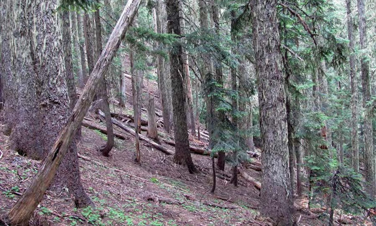
Mountain hemlock is the dominant overstory species in the reference community, and it is the most shade-tolerant species. Subalpine fir, Pacific silver fir, noble fir, and Alaska cedar are subspecies. Reproduction of these species commonly is restricted under a closed canopy of mountain hemlock (Means, 1990). The dense canopy created by multiple age groups of hemlock may block most of the sunlight from the forest floor, which leads to sparse understory in some areas. Gaps in the mid-canopy and overstory allow sunlight to reach the ground. Most of the understory plants are in these areas. The understory is more continuous in areas where there is no mid-canopy. Common understory species include rusty menziesia, black mountain huckleberry, dwarf bramble, sidebells wintergreen, Sitka valerian, common beargrass, and pink mountain heather. The most common natural disturbance on this site is small gap dynamics following the death of some trees. From recorded plot data, the average diameter at breast height of mountain hemlock is 24 inches or more at an age of at least 300 years. The growing conditions of this ecological site limit timber production.
Tree islands are in the alpine areas of this community phase. The krummholtz forests of mountain hemlock and Pacific silver fir are in cold and windy areas along the timberline. The pockets of mature vegetation are 2 to 4 acres in size. The canopy cover in these areas is 25 percent to continuous. With a lack of disturbance and the general warming pattern of the climate in the Pacific Northwest, it is expected that the tree islands will regenerate and expand over time (Means, 1990). The rate of succession of subalpine fir into the overstory is higher in warmer, drier microsites that have an understory of heather (Phyllodoce) (Rochefort, 1996).
Community phase pathway 1.1A
This pathway represents minor disturbances, such as small pockets of root disease, individual tree mortality, and windthrow, that maintain the overall structure of the reference community. Mortality of individual trees or clusters of trees creates gaps in the understory that allow sunlight to reach the forest floor. This promotes the growth of forbs and shrubs and regeneration of overstory species and perpetuates the multi-storied, uneven-aged forest.Forest overstory.Overall cover of mountain hemlock, subalpine fir, Pacific silver fir, Alaska cedar, and noble fir is 40 to 75 percent. The forest has multiple canopy layers. The upper canopy is 80 to 145 feet in height, and it averages 119 feet. The diameter of the trees varies depending on the species, but the average diameter at breast height is 19 inches. The diameter at breast height of noble fir typically is lower than that of mountain hemlock and subalpine fir. The canopy cover and basal area of the tree islands are lower than are those of the reference community.
Forest understory. The composition of the understory varies depending on the overstory cover and competition for sunlight and moisture. As the overstory community matures toward the reference state, the understory vegetation is less prevalent and more sparse. At the higher elevations, the density of the understory species is higher because the trees are less mature and the canopy is not closed. Overall cover of shrubs such as black mountain huckleberry, sidebells wintergreen, and white rhododendron is 1 to 55 percent. Dense pockets of shrubs develop in some areas. Overall cover of forbs such as common beargrass, Sitka valerian, five-leaved bramble, and arctic lupine is 1 to 30 percent.
Dominant plant species
-
mountain hemlock (Tsuga mertensiana), tree
-
subalpine fir (Abies lasiocarpa), tree
-
Pacific silver fir (Abies amabilis), tree
-
noble fir (Abies procera), tree
-
Alaska cedar (Callitropsis nootkatensis), tree
-
rusty menziesia (Menziesia ferruginea), shrub
-
thinleaf huckleberry (Vaccinium membranaceum), shrub
-
pink mountainheath (Phyllodoce empetriformis), shrub
-
common beargrass (Xerophyllum tenax), other herbaceous
-
roughfruit berry (Rubus lasiococcus), other herbaceous
-
Sitka valerian (Valeriana sitchensis), other herbaceous
Community 1.2
Mountain Hemlock, Subalpine Fir, Rusty Menziesia, and Common BeargrassStructure: Mosaic of mature overstory and regenerating openings following root rot infestation
Community phase 1.2 has some areas that resemble community phase 1.1, but it also has moderate-sized openings (2 to 4 acres). Many of the shrubs, including rusty menziesia, common beargrass, dwarf bramble, and Sitka valerian, respond well to increased sunlight. This may delay or prevent reforestation of the openings.Dominant plant species
-
mountain hemlock (Tsuga mertensiana), tree
-
subalpine fir (Abies lasiocarpa), tree
-
rusty menziesia (Menziesia ferruginea), shrub
-
common beargrass (Xerophyllum tenax), other herbaceous
Community 1.3
American Bistort, Fireweed, and Common BeargrassStructure: Open meadow with snags
Community phase 1.3 is an early seral plant community that has been impacted by a stand-replacing disturbance such as a wildfire, large-scale windstorm, mass movement, or major insect infestation. Mountain hemlock is susceptible to damage from fire because of its low-hanging branches. It is not expected to survive moderate- or high-intensity fires; therefore, the fires are dominantly stand replacing (Tesky, 1992). Most of the trees are destroyed, but some fire-resistant trees may survive in the overstory. Standing, decaying snags are prevalent. The understory is dominantly shrubs and forbs such as American bistort, fireweed, common beargrass, and arctic lupine. Some grasses will establish, but they will be replaced by shrubs over time. Tree seedlings and saplings begin to establish within 3 to 10 years, depending on severity of the disturbance.Dominant plant species
-
American bistort (Polygonum bistortoides), other herbaceous
-
common beargrass (Xerophyllum tenax), other herbaceous
-
fireweed (Chamerion angustifolium), other herbaceous
Community 1.4
Western White Pine, Subalpine Fir, American Bistort, and Arctic LupineStructure: Single story
Community phase 1.4 is an early seral forest in regeneration. Scattered remnant mature trees that are fire-resilient may be present. The species composition depends on the natural seed sources present and the intensity of the disturbance. Western white pine and subalpine fir are suited to reproduction after a disturbance (Means, 1990). After a moderate or severe fire, shrubs and forbs may outcompete tree seedlings. American bistort, arctic lupine, and partridgefoot, which may have been moderate in abundance previously, rapidly recover and spread when top-killed. This slows the regeneration of the overstory species. Tree species, including early successional species such as western white pine, commonly regenerate from an existing seed source. The stand is mixed and may include western white pine, Douglas-fir, mountain hemlock, and subalpine fir.Dominant plant species
-
western white pine (Pinus monticola), tree
-
subalpine fir (Abies lasiocarpa), tree
-
American bistort (Polygonum bistortoides), other herbaceous
-
arctic lupine (Lupinus arcticus), other herbaceous
Community 1.5
Subalpine Fir, Mountain Hemlock, Purple Mountain Heather, and Arctic Lupine
Structure: Dense single story with diminished understory
Community phase 1.5 is a forest in the competitive exclusion stage. Scattered remnant mature trees may be present. Individual trees compete for available water and nutrients. The canopy closure is nearly 100 percent, which leads to a diminished understory. Some understory species better adapted to at least partial shade, such as Sitka valerian, increase in abundance. Over time, the forest will begin to self-thin due to competition. The species composition depends on the original seed sources available. The forest consists of a single species or mixed species, including subalpine fir, mountain hemlock, Pacific silver fir, Alaska cedar, and Engelmann spruce.Dominant plant species
-
subalpine fir (Abies lasiocarpa), tree
-
mountain hemlock (Tsuga mertensiana), tree
-
Pacific silver fir (Abies amabilis), tree
-
Engelmann spruce (Picea engelmannii), tree
-
Alaska cedar (Callitropsis nootkatensis), tree
-
pink mountainheath (Phyllodoce empetriformis), shrub
-
arctic lupine (Lupinus arcticus), other herbaceous
-
Sitka valerian (Valeriana sitchensis), other herbaceous
Community 1.6
Subalpine Fir, Mountain Hemlock, Rusty Menziesia, and Dwarf BrambleStructure: Single story with few small openings
Community phase 1.6 is a maturing forest that is beginning to differentiate vertically. Individual trees are dying from competition, disease, insects, or windthrow, which allows some sunlight to reach the forest floor. The understory increases in abundance, and some pockets of overstory regeneration develop.Dominant plant species
-
subalpine fir (Abies lasiocarpa), tree
-
mountain hemlock (Tsuga mertensiana), tree
-
Pacific silver fir (Abies amabilis), tree
-
Alaska cedar (Callitropsis nootkatensis), tree
-
rusty menziesia (Menziesia ferruginea), shrub
-
roughfruit berry (Rubus lasiococcus), other herbaceous
Pathway 1.1B
Community 1.1 to 1.2This pathway represents a larger disturbance, such as a windstorm, insect infestation, or pocket of root rot. Areas of regeneration are 2 to 4 acres in size. Historically, this spatial pattern was caused by pockets of disease, such as annosum root rot (Heterobasidion annosum) or laminated root rot (Phellinus weirii); minor insect infestations; or low- to moderate-intensity fires. Because mountain hemlock is shallow rooted, it is susceptible to laminated root rot and windthrow (Tesky, 1992).
Pathway 1.1C
Community 1.1 to 1.3This pathway represents a major stand-replacing disturbance, such as a high-intensity fire, large-scale windstorm, major insect infestation, or large mass movement. The frequency of fire is 400 to 800 years. Volcanic activity has the potential to disrupt the landscape ecology beyond the boundaries of the ecological site and the purpose of this site description.
Pathway 1.2A
Community 1.2 to 1.1This pathway represents growth over time with no further significant disturbance. The areas of regeneration go through the typical phases of stands, including competitive exclusion, maturation, and understory reinitiation, until they resemble the old-growth structure of the reference community.
Pathway 1.2B
Community 1.2 to 1.3This pathway represents a major stand-replacing disturbance such as a high-intensity fire, large-scale windstorm, major insect infestation, or large mass movement. This leads to the initiation phase of forest development.
Pathway 1.3A
Community 1.3 to 1.4This pathway represents growth over time with no further major disturbance.
Pathway 1.4B
Community 1.4 to 1.3This pathway represents a major stand-replacing disturbance such as a high-intensity fire, large-scale windstorm, major insect infestation, or large mass movement. This leads to the initiation phase of forest development.
Pathway 1.4A
Community 1.4 to 1.5This pathway represents growth over time with no further major disturbance.
Pathway 1.5B
Community 1.5 to 1.3This pathway represents a major stand-replacing disturbance such as a high-intensity fire, large-scale windstorm, major insect infestation, or large mass movement. This leads to the initiation phase of forest development.
Pathway 1.5A
Community 1.5 to 1.6This pathway represents growth over time with no further major disturbance.
Pathway 1.6A
Community 1.6 to 1.1This pathway represents growth over time with no further major disturbance. Continued growth over time and ongoing mortality lead to increased vertical diversification. The community begins to resemble the structure of the reference community, including small pockets of regeneration and a more diversified understory.
Pathway 1.6B
Community 1.6 to 1.3This pathway represents a major stand-replacing disturbance such as a high-intensity fire, large-scale windstorm, major insect infestation, or large mass movement. This leads to the initiation phase of forest development.
Additional community tables
Table 5. Community 1.1 plant community composition
Group Common name Symbol Scientific name Annual production () Foliar cover (%) Table 6. Community 1.1 forest overstory composition
Common name Symbol Scientific name Nativity Height ft Canopy cover (%) Diameter in Basal area (square ft/acre) Treemountain hemlock TSME Tsuga mertensiana Native – – – 0 subalpine fir ABLA Abies lasiocarpa Native – – – 0 Pacific silver fir ABAM Abies amabilis Native – – – 0 Alaska cedar CANO9 Callitropsis nootkatensis Native – – – 0 noble fir ABPR Abies procera Native – – – 0 Table 7. Community 1.1 forest understory composition
Common name Symbol Scientific name Nativity Height (ft) Canopy cover (%) Forb/HerbSitka valerian VASI Valeriana sitchensis Native 0–36 0–50 common beargrass XETE Xerophyllum tenax Native 0–36 0–40 strawberryleaf raspberry RUPE Rubus pedatus Native 0–6 0–30 arctic lupine LUAR2 Lupinus arcticus Native 0–24 0–30 white avalanche-lily ERMO8 Erythronium montanum Native 0–24 0–20 Shrub/Subshrubthinleaf huckleberry VAME Vaccinium membranaceum Native 0–48 0–55 sidebells wintergreen ORSE Orthilia secunda Native 0–12 0–40 Cascade azalea RHAL2 Rhododendron albiflorum Native 0–72 0–35 rusty menziesia MEFE Menziesia ferruginea Native 0–60 0–30 pink mountainheath PHEM Phyllodoce empetriformis Native 0–18 0–20 western mountain ash SOSI2 Sorbus sitchensis Native 0–36 0–10 Table 8. Community 1.2 plant community composition
Group Common name Symbol Scientific name Annual production () Foliar cover (%) Table 9. Community 1.3 plant community composition
Group Common name Symbol Scientific name Annual production () Foliar cover (%) Table 10. Community 1.4 plant community composition
Group Common name Symbol Scientific name Annual production () Foliar cover (%) Table 11. Community 1.5 plant community composition
Group Common name Symbol Scientific name Annual production () Foliar cover (%) Table 12. Community 1.6 plant community composition
Group Common name Symbol Scientific name Annual production () Foliar cover (%) Interpretations
Animal community
Migratory birds nest throughout Mount Rainier National Park in summer. Mammals such as elk, deer, and black bear forage at the higher elevations during peak periods in summer. Mountain goats, pika, and marmots maintain habitat in the high alpine and subalpine communities.
Recreational uses
The alpine environment of this site provides hiking opportunities when free of snow in June through September.
Other information
Pathogen Information
Mountain hemlock forests of the Washington and Oregon Cascade Mountains are highly susceptible to laminated root rot (Phellinus weirii), which results in moderate disturbances and openings in the forest. The fungus can cause severe root rot and butt decay that stunt the growth of trees and cause mortality. Pacific silver fir, subalpine fir, and noble fir may be affected by laminated root rot, but they rarely are killed by the disease.
Signs and symptoms of root rot include pockets of dead and fallen trees that are broken at or near ground level. The decay is identified by brown to reddish brown speckled staining in the sapwood and wood that separates along the growth rings. Regeneration of highly susceptible species in infected areas typically is unsuccessful (Goheen, 2006).
White pine blister rust (Cronartium ribicola) affects the early seral white pine forest, and it may result in mortality of young trees. This disease commonly increases the rates of succession and transition by girdling infected trees. It affects five-needled pines. It commonly precedes an attack by mountain pine beetles in areas where large stands of western white pine are stressed or dying. This fungus requires an alternate currant (Ribes spp.) host to complete its lifecycle.
An identifier of blister rust commonly is swellings on branches, which exude sap in spring. Cankers and pustules that have yellow-orange blisters (aeciospores) by midsummer develop on branches and boles of trees. Management may include removal of the currant (Ribes spp.), pruning affected branches, and planting genetically improved stock (Goheen, 2006).Supporting information
Inventory data references
Other Established Classifications National vegetation classification: North Pacific Mountain Hemlock-Silver Fir Forest and Tree Island Group U.S. Department of Agriculture, Forest Service, plant association: •TSME/VAME-VASI •TSME/VAME-XETE U.S. Department of the Interior, National Park Service, plant association: •TSUMER-ABILAS/VACDEL-PHYEMP •PHYEMP-VACDEL-(CASMER)
Type locality
Location 1: Pierce County, WA Township/Range/Section T16N R10E S22 Latitude 46° 51′ 56″ Longitude 121° 31′ 53″ Other references
Barnes, George H. 1962. Yield of even-aged stands of western hemlock. U.S. Department of Agriculture, Forest Service, Pacific Northwest Forest and Range Experiment Station Technical Bulletin 1273.
Crawford, R.C., C.B. Chappell, C.C. Thompson, and F.J. Rocchio. 2009. Vegetation classification of Mount Rainier, North Cascades, and Olympic National Parks. Natural Resource Technical Report NPS/NCCN/NRTR-2009/211. National Park Service, Fort Collins, Colorado.
Goheen, E.M., and E.A. Willhite. 2006. Field guide to common diseases and insect pests of Oregon and Washington conifers. U.S. Department of Agriculture, Forest Service, Pacific Northwest Region R6-NR-FID-PR-01-06.
Hanley, D.P., and D.M. Baumgartner. 2002. Forest ecology in Washington. Washington State University Cooperative Extension Technical Report EB 1943.
Hanson, E.J., D.L. Azuma, and B.A. Hiserote. 2002. Site index equations and mean annual increment equations for Pacific Northwest Research Station forest inventory and analysis inventories, 1985-2001. U.S. Department of Agriculture, Forest Service, Pacific Northwest Research Station Research Note PNW-RN-533.
Henderson, J.A., R.D. Lesher, D.H. Peter, and D.C. Shaw. 1992. Field guide to the forested plant associations of the Mt. Baker-Snoqualmie National Forest. U.S. Department of Agriculture, Forest Service, Pacific Northwest Region Technical Paper R6-ECOL-TP-028-91.
King, James E. 1966. Site index curves for Douglas-fir in the Pacific Northwest. Weyerhaeuser Company, Forestry Research Center Forestry Paper 8.
Kittel, G., D. Meidinger, and D. Faber-Langendoen. 2015. G240 Pseudotsuga menziesii-Tsuga heterophylla/Gaultheria shallon forest group. United States National Vegetation Classification. Federal Geographic Data Committee, Vegetation Subcommittee, Washington, D.C.
Means, J.E. 1990. Tsuga mertensiana. In Silvics of North America: Volume 1. Conifers. U.S. Department of Agriculture, Forest Service, Agriculture Handbook 654. Pages 623-634. https://www.srs.fs.usda.gov/pubs/misc/ag_654_vol1.pdf
Pojar, J., and A. MacKinnon. 1994. Plants of the Pacific Northwest Coast. Lone Pine, Vancouver, British Columbia.
PRISM Climate Group. Oregon State University. Accessed February 2015. http://prism.oregonstate.edu
Rochefort, R.M., and D.L. Peterson. 1996. Temporal and spatial distribution of trees in subalpine meadows of Mount Rainier National Park. Arctic and Alpine Research. Volume 28, number 1, pages 52-59.
Seastedt, T.R., and G.A. Adams. 2001. Effects of mobile tree islands on alpine tundra soils. Ecology. Volume 82, pages 8-17. Scientia Silvica. 1997. Regeneration patterns in the mountain hemlock zone. Extension Series, Number 6.
Smith, K., G. Kuhn, and L. Townsend. 2008. Culmination of mean annual increment for indicator tree species in the State of Washington. U.S. Department of Agriculture, Natural Resources Conservation Service, Technical Note Forestry-9.
Tesky, J.L. 1992. Tsuga mertensiana. In Fire Effects Information System. U.S. Department of Agriculture, Forest Service, Rocky Mountain Research Station, Fire Sciences Laboratory. https://www.fs.fed.us/database/feis/plants/tree/tsumer/all.html
Topik, C., N.M. Halverson, and D.G. Brockway. 1986. Plant associations and management guide for the western hemlock zone, Gifford Pinchot National Forest. U.S. Department of Agriculture, Forest Service, Pacific Northwest Region Technical Paper R6-ECOL-230A-1986.
United States Department of Agriculture, Forest Service. 1990. Silvics of North America. Agriculture Handbook 654. https://www.fs.usda.gov/naspf/
United States Department of Agriculture, Natural Resources Conservation Service, and United States Department of the Interior, National Park Service. 2014. Ecological site descriptions for North Cascades National Park Complex, Washington.Contributors
Erin Kreutz
Erik Dahlke
Philip RobertsApproval
Kirt Walstad, 2/03/2025
Rangeland health reference sheet
Interpreting Indicators of Rangeland Health is a qualitative assessment protocol used to determine ecosystem condition based on benchmark characteristics described in the Reference Sheet. A suite of 17 (or more) indicators are typically considered in an assessment. The ecological site(s) representative of an assessment location must be known prior to applying the protocol and must be verified based on soils and climate. Current plant community cannot be used to identify the ecological site.
Author(s)/participant(s) Contact for lead author Date 05/10/2024 Approved by Approval date Composition (Indicators 10 and 12) based on Annual Production Indicators
-
Number and extent of rills:
-
Presence of water flow patterns:
-
Number and height of erosional pedestals or terracettes:
-
Bare ground from Ecological Site Description or other studies (rock, litter, lichen, moss, plant canopy are not bare ground):
-
Number of gullies and erosion associated with gullies:
-
Extent of wind scoured, blowouts and/or depositional areas:
-
Amount of litter movement (describe size and distance expected to travel):
-
Soil surface (top few mm) resistance to erosion (stability values are averages - most sites will show a range of values):
-
Soil surface structure and SOM content (include type of structure and A-horizon color and thickness):
-
Effect of community phase composition (relative proportion of different functional groups) and spatial distribution on infiltration and runoff:
-
Presence and thickness of compaction layer (usually none; describe soil profile features which may be mistaken for compaction on this site):
-
Functional/Structural Groups (list in order of descending dominance by above-ground annual-production or live foliar cover using symbols: >>, >, = to indicate much greater than, greater than, and equal to):
Dominant:
Sub-dominant:
Other:
Additional:
-
Amount of plant mortality and decadence (include which functional groups are expected to show mortality or decadence):
-
Average percent litter cover (%) and depth ( in):
-
Expected annual annual-production (this is TOTAL above-ground annual-production, not just forage annual-production):
-
Potential invasive (including noxious) species (native and non-native). List species which BOTH characterize degraded states and have the potential to become a dominant or co-dominant species on the ecological site if their future establishment and growth is not actively controlled by management interventions. Species that become dominant for only one to several years (e.g., short-term response to drought or wildfire) are not invasive plants. Note that unlike other indicators, we are describing what is NOT expected in the reference state for the ecological site:
-
Perennial plant reproductive capability:
Print Options
Sections
Font
AAAAOther
PrintThe Ecosystem Dynamics Interpretive Tool is an information system framework developed by the USDA-ARS Jornada Experimental Range, USDA Natural Resources Conservation Service, and New Mexico State University.
Accessibility statement


