
Natural Resources
Conservation Service
Ecological site F003XN944WA
Southern Washington Cascades Low Cryic Riparian Forest
Last updated: 1/30/2025
Accessed: 09/13/2026
-
Search


Major Land Resource Area or ecological site by name and/or ID.
PreviousSectionsNextGeneral information
Provisional. A provisional ecological site description has undergone quality control and quality assurance review. It contains a working state and transition model and enough information to identify the ecological site.
MLRA notes
Major Land Resource Area (MLRA): 003X–Olympic and Cascade Mountains
Steep mountains and narrow to broad, gently sloping valleys characterize this MLRA. A triple junction of two oceanic plates and one continental plate is directly offshore from Puget Sound. Subduction of the oceanic plates under the westerly and northwesterly moving continental plate contributes to volcanic activity in the Cascade Mountains. Movement among these plates has resulted in major earthquakes and the formation of large stratovolcanoes. The Cascade Mountains consist primarily of volcanic crystalline rock and some associated metasedimentary rock. The mean annual precipitation is dominantly 60 to 100 inches, but it is 30 to 60 inches on the east side of the Cascade Mountains.
The soil orders in this MLRA are dominantly Andisols, Spodosols, and Inceptisols and minor areas of Entisols and Histosols. The soils are dominantly in the frigid or cryic temperature regime and the udic moisture regime. The soils generally are shallow to very deep, well drained, ashy to medial, and loamy or sandy. They are on mountain slopes and ridges.Ecological site concept
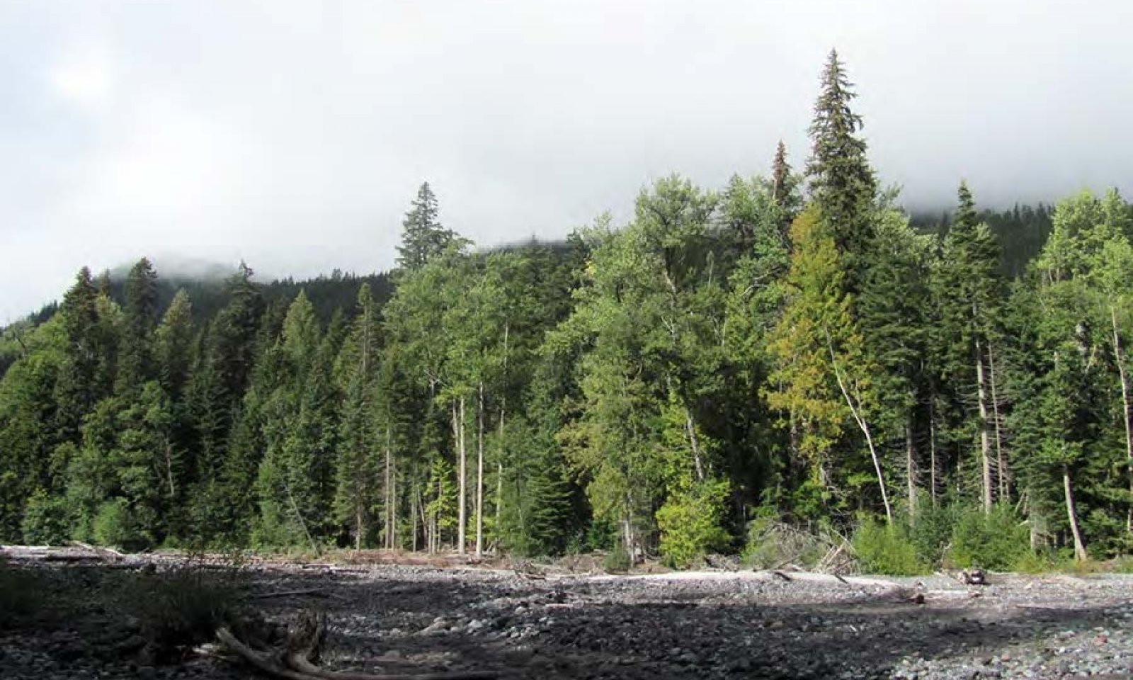
This ecological site is in cold, moist areas of Mount Rainier National Park at middle to high elevations (2,000 to 6,100 feet). Elevation and climate are key components in the succession of the forest dynamics. The cold winters and mild summers affect the rates of growth and maturity of species. This site is along active flood plains, valleys, and terraces of river valley bottoms that have a seasonal high water table, which influences the dynamics of the vegetation. The most common natural disturbance is flooding. The volume and longevity of the flooding determine the effect on the dynamics of the forest.
The soils that support this ecological site are in the cryic soil temperature regime and the udic soil moisture regime. The soils are subject to rare periods of flooding in April, May, October, and November. Soil moisture is not a limiting factor to forest growth because of the abundance of precipitation and the inherent water-holding properties of soils influenced by volcanic ash. Slope and aspect are not defining features of this site.
Black cottonwood (Populus balsamifera ssp. Trichocarpa) and Pacific silver fir (Abies amabilis) are the most common overstory species. The site supports a variety of species, including western redcedar (Thuja plicata), Sitka alder (Alnus viridis ssp. sinuata), western hemlock (Tsuga heterophylla), Engelmann spruce (Picea engelmannii), and Douglas-fir (Pseudotsuga menziesii). Regeneration commonly is limited by the frequency of flooding.Associated sites
F003XN947WA Southern Washington Cascades Low Cryic Coniferous Forest
Site F003XN944WA is in an earlier forest successional stage because of frequent disturbance compared to F003XN947WA. It is expected that in the absence of flooding, ecological site F003XN944WA will mature into an old-growth forest resembling that of site F003XN947WA.
Similar sites
F003XN940WA Southern Washington Cascades Frigid Riparian Forest
Ecological Site F003XN944WA, Southern Washington Cascades Low Cryic Riparian Forest, has features that are similar to those of site F003XN940WA, Southern Washington Frigid Riparian Forest. Both ecological sites are influenced by flood dynamics and similar disturbance patterns; however, elevation distinguishes the sites. Ecological site F003XN940WA is at an elevation of 1,600 to 2,100 feet, and site F003XN944WA is at an elevation of more than 2,100 feet. Site F003XN944WA supports species more common at higher elevations, such as Pacific silver fir. The productivity of the forest on site F003XN940WA is higher as a result of the longer growing season, warmer temperatures, and reduced snowpack.
F003XN949WA Southern Washington Cascades High Cryic Riparian Forest
Ecological site F003XN949WA is located at high elevations compared to site F003XN944WA, Southern Washington Cascades Low Cryic Riparian Forest. Both sites are associated with the Flett soils and are subject to intense flooding. Site F003XN949WA is in colder, wetter areas at high elevations; thus, the growing conditions are harsher. Ecological site F003XN944WA supports black cottonwood and Pacific silver fir in the reference community, and site F003XN949WA supports Alaska cedar and Sitka alder. The rates of maturity and growth of species are lower on site F003XN949WA than they are on site F003XN944WA.
Table 1. Dominant plant species
Tree (1) Populus balsamifera ssp. trichocarpa
(2) Abies amabilisShrub (1) Acer circinatum
Herbaceous (1) Polystichum munitum
Physiographic features
This ecological site occurs on terraces of river valley bottoms, active flood plains, and valleys at middle to high elevations (2,000 to 6,100 feet) in Mount Rainier National Park. Slope commonly is 0 to 15 percent.
Table 2. Representative physiographic features
Landforms (1) River valley > Terrace
(2) River valley > Flood plain
(3) River valley > Valley
Flooding frequency None to rare Ponding frequency None Elevation 2000 – 6100 ft Slope 0 – 15 % Water table depth 20 – 60 in Aspect W, NW, N, NE, E, SE, S, SW Climatic features
Most of the annual precipitation is received in October through March. The mean annual precipitation is 50 to 115 inches, and the mean annual air temperature is 27 to 63 degrees F. Generally, the summers are cool and dry and the winters are cold and wet.
Table 3 Representative climatic features
Frost-free period (characteristic range) 60-90 days Freeze-free period (characteristic range) Precipitation total (characteristic range) 50-120 in BarLineFigure 1. Monthly precipitation range
BarLineFigure 2. Monthly minimum temperature range
">Influencing water features
This site is at middle to high elevations of active flood plains, valleys, and terraces of river valley bottoms in Mount Rainier National Park. The site is not subject to ponding. The frequency of flooding is rare; however, 100- or 500-year floods may dramatically alter the landscape. The water table typically rises in spring and recedes in fall.
Soil features
Applicable soils: Flett, Narada
Applicable soil map units in Mount Rainier National Park: 8100, 8101
The soils that support this site are in the cryic soil temperature regime and the udic soil moisture regime. The Narada soils are moderately well drained, and the Flett soils are somewhat excessively drained. Both soils are very deep. The soils are on active flood plains, valleys, and terraces of river valley bottoms. They formed in alluvium derived from andesite mixed with volcanic ash. The Narada soils have a seasonal high water table at a depth of 20 to 40 inches at some time during the growing season. Both soils are subject to rare periods of flooding in April, May, October, and November. The Flett soils have more than 35 percent rock fragments in the control section. Both soils are coarse textured and primarily ashy loamy sand and ashy sandy loam. Podsolization is not evident in the soils because of the relative young age in terms of soil formation. Both of the soils have an ochric epipedon and a cambic horizonTable 4. Representative soil features
Parent material (1) Alluvium – andesite
Surface texture (1) Very stony, ashy coarse sandy loam
(2) Ashy fine sandy loam
(3) Gravelly, ashy loamy sand
Drainage class Moderately well drained to somewhat excessively drained Soil depth 60 in Surface fragment cover <=3" 15 – 60 % Surface fragment cover >3" 0 – 30 % Available water capacity
(Depth not specified)3.5 – 7.2 in Soil reaction (1:1 water)
(Depth not specified)3.5 – 6 Subsurface fragment volume <=3"
(Depth not specified)0 – 55 % Subsurface fragment volume >3"
(Depth not specified)0 – 60 % Ecological dynamics
This ecological site is on active flood plains, valleys, and terraces of river valley bottoms that have a seasonal high water table. Black cottonwood (Populus balsamifera ssp. Trichocarpa) and Pacific silver fir (Abies amabilis) are the most common overstory species. The forest supports a variety of species, including western redcedar (Thuja plicata), Sitka alder (Alnus viridis ssp. sinuata), western hemlock (Tsuga heterophylla), Engelmann spruce (Picea engelmannii), and Douglas-fir (Pseudotsuga menziesii).
The most common natural disturbance is flooding. The volume and longevity of the flooding determine the effect on the dynamics of the forest. Small, frequent periods of peak flow do not tend to impact the flow of the channel, but a considerable amount of sediment commonly is transported during these periods. Extreme rain-on-snow flooding and debris flows can alter the stream channel through incision or aggradation and remove existing vegetation along the flood plains, resulting in a stand-replacing event (Czuba, 2012).
Black cottonwood and red alder germinate most successfully on the barren mineral soils scoured by flooding. During a long period between major floods, conifers become established and the overstory becomes more diverse. The understory commonly is shrubby. Vine maple (Acer circinatum), Barclay’s willow (Salix barclayi), and red huckleberry (Vaccinium parvifolium) make up the dense subcanopy. In the more flood-prone areas, the shrubs may be less dense, allowing more light to reach the forest floor. An herb layer consisting of western swordfern (Polystichum munitum), fireweed (Chamerion angustifolium), and prince’s pine (Chimaphila umbellata) is in scattered areas.
Location on the landscape is the most important factor determining the species composition of this ecological site. Conifers are prevalent on the terraces and adjacent hillsides, and deciduous species are on the active flood plains that are subject to more frequent fluvial disturbances (Villarin, 2009). In the absence of disturbance, it is expected that the maturation and succession of the forest will result in an old-growth conifer forest.State and transition model
Custom diagramStandard diagram
More interactive model formats are also available. View Interactive Models
More interactive model formats are also available. View Interactive Models
Click on state and transition labels to scroll to the respective textEcosystem states
State 2 submodel, plant communities
State 1
ReferenceCommunity 1.1
Black Cottonwood, Pacific Silver Fir, Vine Maple, and Western Swordfern
Structure: Mature mixed conifer and deciduous forest with shrubs and conifer regeneration in the understory
The reference community represents an absence of major flooding for at least 80 years. Conifers are prevalent on the terraces and adjacent hillsides, and deciduous species are on the active flood plains, where frequent fluvial disturbances occur. Remnant mature early seral species, such as black cottonwood, are in the overstory. Over time, shade-tolerant conifers such as Pacific silver fir, Douglas-fir, western hemlock, and western redcedar regenerate in the understory. The absence of flooding allows for growth of a vigorous understory of shrubs, including vine maple, prince’s pine, salal, and red huckleberry. Common disturbances include small gap dynamics (openings of 1/2 acre or smaller) following the decline of the shade-intolerant species and minor scouring from flooding.
Community phase pathway 1.1A
This pathway represents minor disturbances that maintain the overall structure of the reference community. The mortality of one or two trees creates gaps in the understory that allow sunlight to reach the forest floor. This promotes growth of forbs and shrubs and regeneration of overstory species. Deposition of soil material following minor scouring from flooding temporarily affects the understory community, but it does not alter the composition of the overstory.Forest overstory.Douglas-fir, Pacific silver fir, western redcedar, western hemlock, red alder, and black cottonwood make up the forest canopy. The forest has multiple layers. The upper canopy is 100 to 200 feet in height, and it averages 90 feet. The diameter of the trees varies depending on species, but the average diameter at breast height is 20 inches.
Forest understory. The composition of the understory varies depending on the overstory cover and competition for moisture. Overall cover of shrubs such as salal and red huckleberry is 15 to 25 percent in the reference community. Overall cover of forbs such as twinflower, western rattlesnake plantain, and pipsissewa is as much as 20 percent.
Dominant plant species
-
black cottonwood (Populus balsamifera ssp. trichocarpa), tree
-
Pacific silver fir (Abies amabilis), tree
-
western redcedar (Thuja plicata), tree
-
western hemlock (Tsuga heterophylla), tree
-
Engelmann spruce (Picea engelmannii), tree
-
Douglas-fir (Pseudotsuga menziesii), tree
-
Sitka alder (Alnus viridis ssp. sinuata), shrub
-
vine maple (Acer circinatum), shrub
-
Barclay's willow (Salix barclayi), shrub
-
red huckleberry (Vaccinium parvifolium), shrub
-
pipsissewa (Chimaphila umbellata), shrub
-
salal (Gaultheria shallon), shrub
-
western swordfern (Polystichum munitum), other herbaceous
Community 1.2
Black Cottonwood, Red Alder, Vine Maple, and Western Swordfern
Structure: Single story
Community phase 1.2 represents a forest that is undergoing regeneration or stand initiation. Scattered remnant mature trees are in some areas. Successful regeneration is dependent on a local seed source, an adequate seedbed, and sufficient light and water (Nierenberg, 2000). Black cottonwood, red alder, and vine maple are the pioneering early seral species that become established first after a major disturbance. These deciduous species establish quickly as compared to conifers. Red alder fixes nitrogen, which allows the species to establish rapidly (Villarin, 2009). The seeds of deciduous species are light and can be transported long distances by wind and water, allowing for rapid recolonization. Most of the common shrubs, such as vine maple, can readily regenerate by sprouting from the root crown that has been buried by flood deposits. The shrubs compete with seedlings and saplings until the tree species overtop them. A major disturbance allows for seral forb species to become established. Herbivory by elk, deer, and beaver commonly restricts the maturity of the vegetation (Rot, 1999).Dominant plant species
-
black cottonwood (Populus balsamifera ssp. trichocarpa), tree
-
red alder (Alnus rubra), tree
-
vine maple (Acer circinatum), shrub
-
western swordfern (Polystichum munitum), other herbaceous
Community 1.3
Black Cottonwood, Douglas-fir, Vine Maple, and Western Swordfern
Structure: Dense single story with diminished understory
Community phase 1.3 is a forest in the competitive exclusion stage. Scattered remnant mature trees are in some areas. Individual trees compete for available water and nutrients. Red alder begins to die 40 to 70 years after a disturbance, which allows more light to penetrate the nitrogen-rich soil (Naiman, 2009). Conifer species become more dominant. Downed logs, which are more prevalent in established stands, are important for conifer establishment (Villarin, 2009). The canopy closure is nearly 100 percent, and the understory is diminished. Douglas-fir, a somewhat shade-tolerant species, is dominant in the overstory; however, more shade-tolerant species such as Pacific silver fir, western redcedar, and western hemlock regenerate in the understory. Shrubs are less abundant in areas farther from the flood plains, leading to a closed canopy forest in these areas (Villarin, 2009). If red alder is present, it can be inferred that frequent minor flooding has influenced the dynamics of the site (Nierenberg, 2000). Some understory species that are better adapted to at least partial shade, such as vine maple, remain in the community. Over time, the forest begins to self-thin as a result of competition and a decrease in species that are not tolerant of shade.Dominant plant species
-
black cottonwood (Populus balsamifera ssp. trichocarpa), tree
-
Douglas-fir (Pseudotsuga menziesii), tree
-
red alder (Alnus rubra), tree
-
western hemlock (Tsuga heterophylla), tree
-
Pacific silver fir (Abies amabilis), tree
-
western redcedar (Thuja plicata), tree
-
vine maple (Acer circinatum), shrub
-
western swordfern (Polystichum munitum), other herbaceous
Pathway 1.1B
Community 1.1 to 1.2
Black Cottonwood, Pacific Silver Fir, Vine Maple, and Western Swordfern
Black Cottonwood, Red Alder, Vine Maple, and Western SwordfernThis pathway represents a major 100- to 500-year flood that results in complete or nearly complete loss of the overstory.
Pathway 1.2A
Community 1.2 to 1.3
Black Cottonwood, Red Alder, Vine Maple, and Western Swordfern
Black Cottonwood, Douglas-fir, Vine Maple, and Western SwordfernThis pathway represents growth over time with no further significant disturbance. The areas of regeneration go through the typical stand phases, including competitive exclusion, maturation, and understory reinitiation, until they resemble the old-growth structure of the reference community.
Pathway 1.3B
Community 1.3 to 1.1
Black Cottonwood, Douglas-fir, Vine Maple, and Western Swordfern
Black Cottonwood, Pacific Silver Fir, Vine Maple, and Western SwordfernThis pathway represents no further major disturbance. Continued growth over time and ongoing mortality lead to increased vertical diversification. The community begins to resemble the structure of the reference community, including small pockets of regeneration (both deciduous and coniferous) and a more diversified understory.
Pathway 1.3A
Community 1.3 to 1.2
Black Cottonwood, Douglas-fir, Vine Maple, and Western Swordfern
Black Cottonwood, Red Alder, Vine Maple, and Western SwordfernThis pathway represents a major disturbance from flooding, leading to the stand initiation phase of development.
State 2
Old Growth UndisturbedCommunity 2.1
Pacific Silver Fir, Western Hemlock, Black Mountain Huckleberry, and Twinflower
Structure: Multistory with small gap dynamics
Transition state 2 represents a mature old-growth forest that has been undisturbed by major flooding. Pacific silver fir and western hemlock are the most common overstory species. This transition state and the reference community are considered the most characteristic of Mount Rainier National Park (Crawford, 2009). Pacific silver fir and western hemlock are perhaps the most shade tolerant of any tree species in North America (Crawford, 1990). Douglas-fir, noble fir, and western redcedar are present; however, minimal, if any, Douglas-fir regeneration occurs in closed-canopy forests. The dense canopy consisting of multiple ages of hemlocks may block most of the sunlight from the forest floor, leading to sparse understory vegetation in some areas. The majority of the understory plants become established in areas where gaps in the mid-canopy and overstory allow sunlight to reach the ground. The understory tends to be more continuous in areas where there is no mid-canopy. The most common natural disturbance is small gap dynamics resulting from the mortality of one or two trees or from windthrow. Common understory species include twinflower, black mountain huckleberry, rattlesnake plantain, Cascade Oregon grape, red huckleberry, common beargrass, and deerfoot vanillaleaf.Dominant plant species
-
Pacific silver fir (Abies amabilis), tree
-
western hemlock (Tsuga heterophylla), tree
-
Douglas-fir (Pseudotsuga menziesii), tree
-
noble fir (Abies procera), tree
-
western redcedar (Thuja plicata), tree
-
thinleaf huckleberry (Vaccinium membranaceum), shrub
-
Cascade barberry (Mahonia nervosa), shrub
-
red huckleberry (Vaccinium parvifolium), shrub
-
twinflower (Linnaea borealis), other herbaceous
-
common beargrass (Xerophyllum tenax), other herbaceous
-
western rattlesnake plantain (Goodyera oblongifolia), other herbaceous
-
sweet after death (Achlys triphylla), other herbaceous
Transition T1A
State 1 to 2This pathway represents long-term growth without natural disturbances. Deciduous overstory species are nearly absent, and the plant community shifts to an old-growth conifer forest.
Transition T2B
State 2 to 1This community phase represents a forest that is undergoing regeneration or stand initiation following a 100- to 500-year flood. Scattered remnant mature trees are in some areas.
Additional community tables
Table 5. Community 1.1 plant community composition
Group Common name Symbol Scientific name Annual production () Foliar cover (%) Table 6. Community 1.1 forest overstory composition
Common name Symbol Scientific name Nativity Height ft Canopy cover (%) Diameter in Basal area (square ft/acre) TreePacific silver fir ABAM Abies amabilis Native – – – 0 black cottonwood POBAT Populus balsamifera ssp. trichocarpa Native – – – 0 western redcedar THPL Thuja plicata Native – – – 0 Douglas-fir PSME Pseudotsuga menziesii Native – – – 0 western hemlock TSHE Tsuga heterophylla Native – – – 0 red alder ALRU2 Alnus rubra Native – – – 0 Table 7. Community 1.1 forest understory composition
Common name Symbol Scientific name Nativity Height (ft) Canopy cover (%) Forb/Herbtwinflower LIBO3 Linnaea borealis Native 1–12 0–15 western rattlesnake plantain GOOB2 Goodyera oblongifolia Native 1–12 0–10 white hawkweed HIAL2 Hieracium albiflorum Native 1–24 0–1 Fern/fern allywestern swordfern POMU Polystichum munitum Native 6–36 0–1 Shrub/Subshrublittle prince's pine CHME Chimaphila menziesii Native 0–6 0–30 salal GASH Gaultheria shallon Native 4–36 0–25 pipsissewa CHUM Chimaphila umbellata Native 0–6 0–20 red huckleberry VAPA Vaccinium parvifolium Native 2–36 0–15 Table 8. Community 1.2 plant community composition
Group Common name Symbol Scientific name Annual production () Foliar cover (%) Table 9. Community 1.3 plant community composition
Group Common name Symbol Scientific name Annual production () Foliar cover (%) Table 10. Community 2.1 plant community composition
Group Common name Symbol Scientific name Annual production () Foliar cover (%) Interpretations
Table 11. Representative site productivity
Common name Symbol Site index low Site index high CMAI low CMAI high Age of CMAI Site index curve code Site index curve basis Citation Douglas-fir PSME 134 154 201 241 90 – – Supporting information
Inventory data references
Other Established Classifications U.S. Department of Agriculture, Forest Service, plant association: ABAM/GASH-BENE U.S. Department of the Interior, National Park Service, plant association: ALNRUB/RUBSPE, POPBAL/GAUSHA/POLMUN
Type locality
Location 1: Lewis County, WA Township/Range/Section T15N R10E S21 Latitude 46° 46′ 21″ Longitude 121° 33′ 3″ Other references
Barnes, George H. 1962. Yield of even-aged stands of western hemlock. U.S. Department of Agriculture, Forest Service, Pacific Northwest Forest and Range Experiment Station Technical Bulletin 1273.
Crawford, R.C., C.B. Chappell, C.C. Thompson, and F.J. Rocchio. 2009. Vegetation classification of Mount Rainier, North Cascades, and Olympic National Parks. Natural Resource Technical Report NPS/NCCN/NRTR-2009/211. National Park Service, Fort Collins, Colorado.
Czuba, J., C. Magirl, C. Czuba, C. Curran, K. Johnson, T. Olsen, H. Kimball, and C. Gish. 2012. Geomorphic analysis of the river response to sedimentation downstream of Mount Rainier, Washington. U.S. Geological Survey Open-file Report 2012-1242. Reston, Virginia.
Dwire, K., and J. Kauffman. 2003. Fire and riparian ecosystems in landscapes in the western United States. Forest Ecology and Management. Volume 178, pages 61-74.
Goheen, E.M., and E.A. Willhite. 2006. Field guide to common diseases and insect pests of Oregon and Washington conifers. U.S. Department of Agriculture, Forest Service, Pacific Northwest Region R6-NR-FID-PR-01-06.
Hanley, D.P., and D.M. Baumgartner. 2002. Forest ecology in Washington. Washington State University Cooperative Extension Technical Report EB 1943.
Hanson, E.J., D.L. Azuma, and B.A. Hiserote. 2002. Site index equations and mean annual increment equations for Pacific Northwest Research Station forest inventory and analysis inventories, 1985-2001. U.S. Department of Agriculture, Forest Service, Pacific Northwest Research Station Research Note PNW-RN-533.
Hemstrom, M., and J. Franklin. 1982. Fire and other disturbances of the forests in Mount Rainier National Park. Quaternary Research. Volume 18, pages 32-61.
Henderson, J.A., R.D. Lesher, D.H. Peter, and D.C. Shaw. 1992. Field guide to the forested plant associations of the Mt. Baker-Snoqualmie National Forest. U.S. Department of Agriculture, Forest Service, Pacific Northwest Region Technical Paper R6-ECOL-TP-028-91.
King, James E. 1966. Site index curves for Douglas-fir in the Pacific Northwest. Weyerhaeuser Company, Forestry Research Center Forestry Paper 8.
Kittel, G., D. Meidinger, and D. Faber-Langendoen. 2015. G240 Pseudotsuga menziesii-Tsuga heterophylla/Gaultheria shallon forest group. United States National Vegetation Classification. Federal Geographic Data Committee, Vegetation Subcommittee, Washington, D.C.
Means, J.E. 1990. Tsuga mertensiana. In Silvics of North America: Volume 1. Conifers. U.S. Department of Agriculture, Forest Service, Agriculture Handbook 654. Pages 623-634. https://www.srs.fs.usda.gov/pubs/misc/ag_654_vol1.pdf
Naiman, R., S. Bechtold, T. Beechie, J. Latterell, and R. Van Pelt. 2009. A process-based view of floodplain forest patterns in coastal river valleys of the Pacific Northwest. Ecosystems. Volume 13, pages 1-31. Nierenberg, T., and D. Hibbs. 2000. A characterization of unmanaged riparian areas in the central Coast Range of western Oregon. Forest Ecology and Management. Volume 129, pages 195-206.
Packee, E.C. 1990. Tsuga heterophylla. In Silvics of North America: Volume 1. Conifers. U.S. Department of Agriculture, Forest Service, Agriculture Handbook 654. Pages 613-622. https://www.srs.fs.usda.gov/pubs/misc/ag_654_vol1.pdf
Pojar, J., and A. MacKinnon. 1994. Plants of the Pacific Northwest Coast. Lone Pine, Vancouver, British Columbia.
PRISM Climate Group. Oregon State University. Accessed February 2015. http://prism.oregonstate.edu
Rochefort, R.M., and D.L. Peterson. 1996. Temporal and spatial distribution of trees in subalpine meadows of Mount Rainier National Park. Arctic and Alpine Research. Volume 28, number 1, pages 52-59.
Rot, B., R. Naiman, and E. Bilby. 1999. Stream channel configuration, landform, and riparian forest structure in the Cascade Mountains, Washington. Canadian Journal of Fish and Aquatic Science. Volume 57, pages 699-707.
Seastedt, T.R., and G.A. Adams. 2001. Effects of mobile tree islands on alpine tundra soils. Ecology. Volume 82, pages 8-17. Scientia Silvica. 1997. Regeneration patterns in the mountain hemlock zone. Extension Series, Number 6.
Smith, K., G. Kuhn, and L. Townsend. 2008. Culmination of mean annual increment for indicator tree species in the State of Washington. U.S. Department of Agriculture, Natural Resources Conservation Service, Technical Note Forestry-9.
Tesky, J.L. 1992. Tsuga mertensiana. In Fire Effects Information System. U.S. Department of Agriculture, Forest Service, Rocky Mountain Research Station, Fire Sciences Laboratory. https://www.fs.fed.us/database/feis/plants/tree/tsumer/all.html
Topik, C., N.M. Halverson, and D.G. Brockway. 1986. Plant associations and management guide for the western hemlock zone, Gifford Pinchot National Forest. U.S. Department of Agriculture, Forest Service, Pacific Northwest Region Technical Paper R6-ECOL-230A-1986.
United States Department of Agriculture, Forest Service. 1990. Silvics of North America. Agriculture Handbook 654. https://www.fs.usda.gov/naspf/
United States Department of Agriculture, Natural Resources Conservation Service, and United States Department of the Interior, National Park Service. 2014. Ecological site descriptions for North Cascades National Park Complex, Washington.
Villarin, L., D. Chapin, D., and J. Jones. 2009. Riparian forest structure and succession in second-growth stands of the central Cascade Mountains, Washington, USA. Forest Ecology and Management. Volume 257, pages 1375-1385.Contributors
Erin Kreutz
Erik Dahlke
Philip RobertsApproval
Kirt Walstad, 1/30/2025
Rangeland health reference sheet
Interpreting Indicators of Rangeland Health is a qualitative assessment protocol used to determine ecosystem condition based on benchmark characteristics described in the Reference Sheet. A suite of 17 (or more) indicators are typically considered in an assessment. The ecological site(s) representative of an assessment location must be known prior to applying the protocol and must be verified based on soils and climate. Current plant community cannot be used to identify the ecological site.
Author(s)/participant(s) Contact for lead author Date 05/10/2024 Approved by Approval date Composition (Indicators 10 and 12) based on Annual Production Indicators
-
Number and extent of rills:
-
Presence of water flow patterns:
-
Number and height of erosional pedestals or terracettes:
-
Bare ground from Ecological Site Description or other studies (rock, litter, lichen, moss, plant canopy are not bare ground):
-
Number of gullies and erosion associated with gullies:
-
Extent of wind scoured, blowouts and/or depositional areas:
-
Amount of litter movement (describe size and distance expected to travel):
-
Soil surface (top few mm) resistance to erosion (stability values are averages - most sites will show a range of values):
-
Soil surface structure and SOM content (include type of structure and A-horizon color and thickness):
-
Effect of community phase composition (relative proportion of different functional groups) and spatial distribution on infiltration and runoff:
-
Presence and thickness of compaction layer (usually none; describe soil profile features which may be mistaken for compaction on this site):
-
Functional/Structural Groups (list in order of descending dominance by above-ground annual-production or live foliar cover using symbols: >>, >, = to indicate much greater than, greater than, and equal to):
Dominant:
Sub-dominant:
Other:
Additional:
-
Amount of plant mortality and decadence (include which functional groups are expected to show mortality or decadence):
-
Average percent litter cover (%) and depth ( in):
-
Expected annual annual-production (this is TOTAL above-ground annual-production, not just forage annual-production):
-
Potential invasive (including noxious) species (native and non-native). List species which BOTH characterize degraded states and have the potential to become a dominant or co-dominant species on the ecological site if their future establishment and growth is not actively controlled by management interventions. Species that become dominant for only one to several years (e.g., short-term response to drought or wildfire) are not invasive plants. Note that unlike other indicators, we are describing what is NOT expected in the reference state for the ecological site:
-
Perennial plant reproductive capability:
Print Options
Sections
Font
AAAAOther
PrintThe Ecosystem Dynamics Interpretive Tool is an information system framework developed by the USDA-ARS Jornada Experimental Range, USDA Natural Resources Conservation Service, and New Mexico State University.
Accessibility statement


