
Natural Resources
Conservation Service
Ecological site F003XN925WA
High Cryic/Udic Coniferous
Last updated: 1/30/2025
Accessed: 09/15/2026
-
Search


Major Land Resource Area or ecological site by name and/or ID.
PreviousSectionsNextGeneral information
Provisional. A provisional ecological site description has undergone quality control and quality assurance review. It contains a working state and transition model and enough information to identify the ecological site.
Click to explore map
Figure 1. Mapped extent
Areas shown in blue indicate the maximum mapped extent of this ecological site. Other ecological sites likely occur within the highlighted areas. It is also possible for this ecological site to occur outside of highlighted areas if detailed soil survey has not been completed or recently updated.
Classification relationships
This ecological site is related to the National Park Service Plant Alliances: Tsuga mertensiana-Abies lasiocarpa Forest and Woodland Alliance, Tsuga mertensiana-Abies lasiocarpa-Cupressus (now Callitropsis) nootkatensis Tree Island Alliance (Crawford 2009).
This ecological site includes the following USDA Forest Service Plant Association Groups: Mesic VAME, moist VAAL and PHEM-VADE (Mountain Hemlock Series). (Henderson 1992 p.148)Associated sites
F003XN924WA Low Cryic/Udic West Coniferous
F003XN926WA Cryic/Udic Active Natural Disturbance
F003XN929WA Low Cryic/Udic East Coniferous
Table 1. Dominant plant species
Tree (1) Tsuga mertensiana
(2) Abies lasiocarpaShrub (1) Phyllodoce empetriformis
(2) Vaccinium membranaceumHerbaceous (1) Valeriana sitchensis
(2) Veratrum viridePhysiographic features
This native plant community occurs across many landscape positions at higher elevations of the North Cascades. This site occupies the high cryic/udic soil temperature/moisture regime and extends across glacial valleys and cirque basins to mountain slopes and ridge lines. Sites at the lower elevations will be found on northerly to easterly aspects; at higher elevations aspect no longer affects occurrence.
This ecological site has only been mapped within the boundary of the North Cascades National Park Complex. This site, where mapped, ranged from 3000 to 7000 feet in elevation. The table below refers to the representative elevations of this site.Table 2. Representative physiographic features
Landforms (1) Mountain slope
(2) Valley side
(3) Stream terrace
Flooding duration Very brief (4 to 48 hours) to brief (2 to 7 days) Flooding frequency None to occasional Ponding frequency None Elevation 3000 – 5800 ft Slope 20 – 100 % Water table depth 20 – 0 in Aspect Aspect is not a significant factor Climatic features
This ecological site receives most of its annual precipitation from October to April in the form of snow that will commonly persist into early summer. The mean annual precipitation ranges from 60 to 115 inches and the mean annual temperature ranges from 31 to 47 degrees Fahrenheit. Generally this site occupies areas with cool dry summers and cold wet winters.
Precipitation and temperature data in the tables below was extracted from: PRISM Climate Group, Oregon State University, http://prism.oregonstate.edu, created February 2004. Information from the Ross Dam weather station, was used by the PRISM Climate Group to generate climate data for the North Cascades region.Table 3 Representative climatic features
Frost-free period (average) 60 days Freeze-free period (average) 90 days Precipitation total (average) 120 in BarLineFigure 2. Monthly precipitation range
BarLineFigure 3. Monthly average minimum and maximum temperature
">Influencing water features
In general, this ecological site is not influenced by wetland or riparian water features but may be found on stream terraces or adjacent to wetland and riparian areas. Occasionally and for brief amounts of time, the site may be flooded by adjacent streams but overall this has an insignificant influence on the plant community. Typically the Kimtah or Terror soil series are present in the areas subject to flooding.
Soil features
Applicable soils: Chilliwack, Forbidden, cold, Kimtah, cold, Maggib, Mox, Perfect, cold, Spickard, cold, Terror, cold.
The soils that support this native plant community occur in the high cryic soil temperature regime and udic soil moisture regime (the rooting zone is usually moist throughout the winter and the majority of summer). For the purposes of the soil inventory, the cryic zone (average annual temperature less than 8 degrees C, with less than 5 degrees C difference from winter to summer) was divided into several zones to distinguish soil and/or climatic differences between the lower elevation west side zone (low cryic/udic west), the higher elevation crest zone (high cryic/udic), and lower elevation east side zone (low cryic/udic east). These soils are moderately well to well drained and soil depth ranges from moderately deep to very deep. Generally these soils have a mantle of material with significant volcanic ash influence overlying glacial till or colluvium. The upper mantle is characterized by a low bulk density and high water holding capacity. Soil moisture is not a limiting factor to forest growth on these soils owing to abundance of precipitation and the inherent water holding properties of soils influenced by volcanic ash. Typically under a coniferous overstory, as the amount of precipitation increases the degree of pedogenic weathering increases. Soils of the high cryic zone typically receive the most precipitation of all the coniferous ecological sites. In soils with significant volcanic ash influence and landscape stability (i.e. geologic time), weathering produces Spodosols such as the Chilliwack, Kimtah, Maggib, and Mox soil series. Some soil properties of these Spodosols are similar to the other soils found under this native plant community, but morphologically Spodosols are visually distinct because of the typically bright albic and spodic horizon sequence in the upper soil profile. Weak expression of this morphology may be visible in the Andisols and Inceptisols of this grouping but generally these soils exhibit an ochric epipedon and cambic subsurface diagnostic horizon.
A blank entry under soil depth column indicates no depth restriction within the soil profile.
For more information on soils and their terminology, please refer to Soil taxonomy: A Basic System of Soil Classification for Making and Interpreting Soil Surveys (Soil Survey Staff, 1999; http://soils.usda.gov/technical/classification/taxonomy/).Table 4. Representative soil features
Surface texture (1) Ashy fine sandy loam
(2) Ashy sandy loam
Family particle size (1) Loamy
Drainage class Moderately well drained to well drained Permeability class Moderate to very rapid Soil depth 20 – 0 in Surface fragment cover <=3" 0 – 10 % Surface fragment cover >3" 0 – 10 % Available water capacity
(0-40in)4.2 – 15.99 in Soil reaction (1:1 water)
(0-40in)4 – 7 Subsurface fragment volume <=3"
(Depth not specified)5 – 80 % Subsurface fragment volume >3"
(Depth not specified)5 – 50 % Ecological dynamics
This site is found in cold, moist, higher elevations. The dominant overstory species are mountain hemlock (Tsuga mertensiana) and subalpine fir (Abies lasiocarpa). Other common trees species include Pacific silver fir (Abies amabilis), Alaska yellow-cedar (Callitropsis nootkatensis) and whitebark pine (Pinus albicaulis). Mountain hemlock and Pacific silver fir are considered highly susceptible to laminated root rot (Phellinus weirii), which will cause patches of mortality. Subalpine fir is less susceptible to this root rot while Alaska yellow-cedar and whitebark pine are considered tolerant, giving this fungus the ability to alter forest composition. The historic fire regime of the site is one of low frequency (500+ years) and high intensity and results in a stand replacing event. Common understory shrubs include pink mountainheather (Phyllodoce empetriformis), black huckleberry (Vaccinium membranaceum), Sitka mountain-ash (Sorbus sitchensis) and Cascade huckleberry (Vaccinium deliciosum) while common forbs include Sitka valerian (Valeriana sitchensis), false hellebore (Veratrum viride), sidebells wintergreen (Orthilia secunda) and western meadow-rue (Thalictrum occidentale).
State and transition model
Custom diagramStandard diagram
Figure 4. State and Transition Model
More interactive model formats are also available. View Interactive Models
More interactive model formats are also available. View Interactive Models
Click on state and transition labels to scroll to the respective textEcosystem states
State 1 submodel, plant communities
State 1
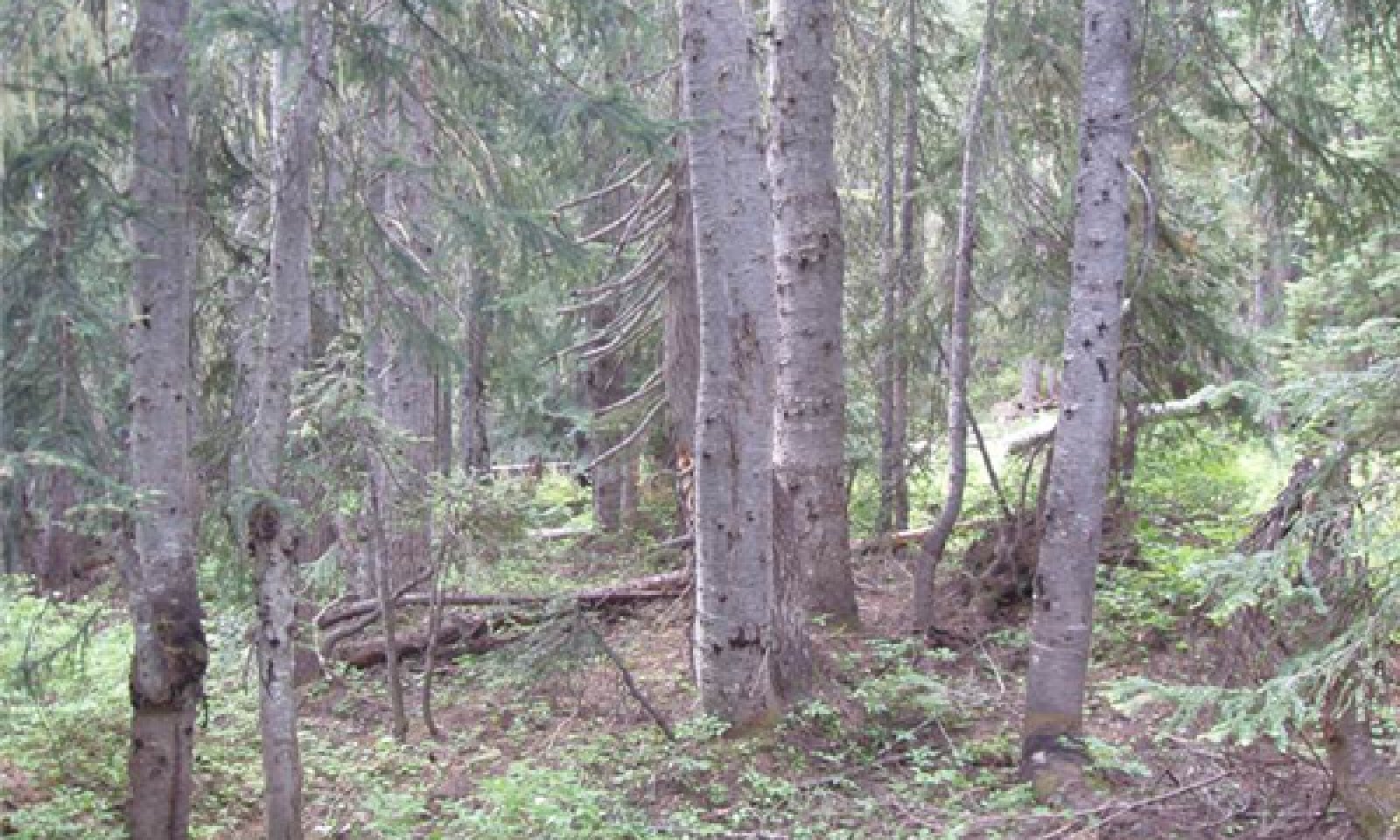
ReferenceCommunity 1.1
Multistory, Mountain Hemlock, Subalpine Fir, Pink Mountain Heather, Black Huckleberry, and Sitka Valerian
Figure 5. Reference Community
Structure: multistory with small gap dynamics
Community Phase 1.1 - Reference Community.
The dominant overstory species are mountain hemlock (Tsuga mertensiana) and subalpine fir (Abies lasiocarpa). Other common trees species include Alaska yellow-cedar (Callitropsis nootkatensis), whitebark pine (Pinus albicaulis) and Pacific silver fir (Abies amabilis). Mountain hemlock and subalpine fir and Pacific silver fir are more susceptible to windthrow than the other overstory species on this site so wind events (as well as pockets of rot) can alter the forest species composition. The ensuing small canopy gaps allow for an increase in the understory of shrubs such as black huckleberry, Sitka mountain-ash, pink mountainheather, Cascade huckleberry and white mountainheather (Cassiope mertensiana) as well as forbs such as Sitka valerian, false hellebore, western meadow-rue and various graminoids.Community 1.2
Mosaic, Mountain Hemlock, Subalpine Fir, Pink Mountain Heather, Black Huckleberry, and Sitka ValerianStructure: mosaic of mature overstory and regenerating openings.
CP 1.2 retains some areas that resemble CP 1.1 but also contains moderate sized (2-5 acres) openings. This spatial pattern would have been caused by pockets of disease or an insect outbreak and while these openings will increase the understory vigor, eventually seedlings from the available seed sources will regenerate and overtop the shrub layer.Community 1.3
Subalpine Fir, Mountain Hemlock, Black Huckleberry, Sitka Mountain Ash and False HelleboreStructure: single story/shrub
CP 1.3 is forestland in regeneration, possibly with scattered remnant mature trees; species composition depends on the natural seed sources present and the intensity of disturbance.
The overstory species found on this site are not adapted to survive moderate or severe wildfire so any seeds would have to come from the surrounding unburned areas or from pockets of trees that were not burned. Vaccinium species are adapted to fire and have the ability to resprout following topkill. An outbreak of balsam woolly adelgid would only affect subalpine fir and Pacific silver fir so other species such as mountain hemlock and whitebark pine would likely provide seed for the regenerating forest.Community 1.4
Subalpine Fir, Mountain Hemlock, Black Huckleberry, Sitka Mountain Ash, and Sitka ValerianStructure: single story
At the lower elevations, CP 1.4 will be a forest in the competitive exclusion stage, with increasing competition among individuals for available water and nutrients. Canopy closure will near 100%, which leads to a diminished understory, and trees will begin to self thin due to the elevated competition. At higher elevations conditions are harsh enough that this forest has more of an open structure where canopy closure rarely exceeds 70-80%. In these cases the forest continues to mature but the ‘competition’ is with the environment rather than among individuals and the understory is more varied.Community 1.5
Subalpine Fir, Mountain Hemlock, Black Huckleberry, Pink Mountain Heather, and Sitka ValerianStructure: single story with few small openings
CP 1.5 is a maturing forest which is starting to differentiate vertically. Individual trees are dying (whether due to insects, disease, competition or windthrow) allowing some sunlight to reach the forest floor. This allows for an increase in the understory as well as some pockets of overstory tree species regeneration.Pathway 1.1A
Community 1.1 to 1.2This pathway represents a larger disturbance – a wind storm, rot pocket or insect outbreak would create this forest structure. Areas of regeneration would range from approximately 2 to 5 acres.
Pathway 1.1B
Community 1.1 to 1.3This pathway represents a major stand-replacing disturbance such as a high-intensity fire, large scale wind event or major insect infestation.
Pathway 1.2A
Community 1.2 to 1.1This pathway represents growth over time with no further significant disturbance. The areas of regeneration pass through the typical stand phases – competitive exclusion, maturation, understory reinitiation – until they resemble the old-growth structure of the reference community.
Pathway 1.2B
Community 1.2 to 1.3This pathway represents a major stand-replacing disturbance leading to the stand initiation phase of forest development.
Pathway 1.3A
Community 1.3 to 1.4This pathway represents growth over time with no further major disturbance.
Pathway 1.4B
Community 1.4 to 1.3This pathway represents a major stand-replacing disturbance leading to the stand initiation phase of forest development.
Pathway 1.4A
Community 1.4 to 1.5This pathway represents continued growth over time with no further major disturbance.
Pathway 1.5A
Community 1.5 to 1.1This pathway represents no further major disturbance. Continued growth over time, as well as ongoing mortality, leads to continued vertical diversification. The community begins to resemble the structure of the reference community, with small pockets of regeneration and a more diversified understory.
Pathway 1.5B
Community 1.5 to 1.3This pathway represents a major stand-replacing disturbance leading to the stand initiation phase of forest development.
Additional community tables
Table 5. Community 1.1 plant community composition
Group Common name Symbol Scientific name Annual production () Foliar cover (%) Table 6. Community 1.1 forest overstory composition
Common name Symbol Scientific name Nativity Height ft Canopy cover (%) Diameter in Basal area (square ft/acre) TreeAlaska cedar CANO9 Callitropsis nootkatensis Native – – – 0 whitebark pine PIAL Pinus albicaulis Native – – – 0 Pacific silver fir ABAM Abies amabilis Native – – – 0 subalpine fir ABLA Abies lasiocarpa Native – – – 0 mountain hemlock TSME Tsuga mertensiana Native – – – 0 Table 7. Community 1.1 forest understory composition
Common name Symbol Scientific name Nativity Height (ft) Canopy cover (%) Forb/Herbgreen false hellebore VEVI Veratrum viride Native 1–3 5–40 Sitka valerian VASI Valeriana sitchensis Native 0.5–2 5–35 sidebells wintergreen ORSE Orthilia secunda Native 0.5–1 1–10 western meadow-rue THOC Thalictrum occidentale Native 0.5–1 1–10 Shrub/Subshrubthinleaf huckleberry VAME Vaccinium membranaceum Native 1–3 5–60 Sitka mountain ash SOSIS2 Sorbus sitchensis var. sitchensis Native 1–4 5–40 Cascade bilberry VADE Vaccinium deliciosum Native 1–3 5–40 pink mountainheath PHEM Phyllodoce empetriformis Native 0.5–2 5–30 Table 8. Community 1.2 plant community composition
Group Common name Symbol Scientific name Annual production () Foliar cover (%) Table 9. Community 1.3 plant community composition
Group Common name Symbol Scientific name Annual production () Foliar cover (%) Table 10. Community 1.4 plant community composition
Group Common name Symbol Scientific name Annual production () Foliar cover (%) Table 11. Community 1.5 plant community composition
Group Common name Symbol Scientific name Annual production () Foliar cover (%) Interpretations
Supporting information
Inventory data references
Type Locality Plot ID: 08-TMR-037
Type locality
Location 1: Chelan County, WA Township/Range/Section T34N R17E S12 UTM zone N UTM northing 5371003 UTM easting 672121 Latitude 48° 28′ 8″ Longitude 120° 40′ 24″ Other references
Agee, J.K. 1993. Fire ecology of Pacific Northwest forests. Covelo, CA: Island Press. 493 pages.
Crawford, R. C., C. B. Chappell, C. C. Thompson, and F. J. Rocchio. 2009. Vegetation classification of Mount Rainier, North Cascades, and Olympic National Parks. Natural Resource Technical Report NPS/NCCN/NRTR—2009/211. National Park Service, Fort Collins, Colorado. 58 pages.
Fire Effects Information System, [Online].
U.S. Department of Agriculture, Forest Service, Rocky Mountain Research Station, Fire Sciences Laboratory (Producer).
http://www.fs.fed.us/database/feis/
Henderson, J., R. Lesher, D. Peter, and D. Shaw. 1992. Field guide to the forested plant associations of the Mt. Baker-Snoqualmie National Forest. Technical paper R6-Ecol-TP-028-91.
Miller, Margaret M.; Miller, Joseph W. 1976. Succession after wildfire in the North Cascades National Park complex. In: Proceedings, annual Tall Timbers fire ecology conference: Pacific Northwest; 1974 October 16-17; Portland, OR. No. 15. Tallahassee, FL: Tall Timbers Research Station: 71-83. [6574]
Perry, D.A. Forest Ecosystems. Baltimore, MD: The Johns Hopkins University Press; 1994. 649 pages.
Pojar, J., and A. MacKinnon. 1994. Plants of the Pacific Northwest Coast. Lone Pine,
Vancouver, British Columbia. 528 pages.
Soil Survey Staff. 1999. Soil taxonomy: A basic system of soil classification for making and interpreting soil surveys. 2nd edition. Natural Resources Conservation Service. U.S. Department of Agriculture Handbook 436. http://soils.usda.gov/technical/classification/taxonomy/
Contributors
Kathryn Smith
Approval
Kirt Walstad, 1/30/2025
Rangeland health reference sheet
Interpreting Indicators of Rangeland Health is a qualitative assessment protocol used to determine ecosystem condition based on benchmark characteristics described in the Reference Sheet. A suite of 17 (or more) indicators are typically considered in an assessment. The ecological site(s) representative of an assessment location must be known prior to applying the protocol and must be verified based on soils and climate. Current plant community cannot be used to identify the ecological site.
Author(s)/participant(s) Contact for lead author Date 01/30/2025 Approved by Approval date Composition (Indicators 10 and 12) based on Annual Production Indicators
-
Number and extent of rills:
-
Presence of water flow patterns:
-
Number and height of erosional pedestals or terracettes:
-
Bare ground from Ecological Site Description or other studies (rock, litter, lichen, moss, plant canopy are not bare ground):
-
Number of gullies and erosion associated with gullies:
-
Extent of wind scoured, blowouts and/or depositional areas:
-
Amount of litter movement (describe size and distance expected to travel):
-
Soil surface (top few mm) resistance to erosion (stability values are averages - most sites will show a range of values):
-
Soil surface structure and SOM content (include type of structure and A-horizon color and thickness):
-
Effect of community phase composition (relative proportion of different functional groups) and spatial distribution on infiltration and runoff:
-
Presence and thickness of compaction layer (usually none; describe soil profile features which may be mistaken for compaction on this site):
-
Functional/Structural Groups (list in order of descending dominance by above-ground annual-production or live foliar cover using symbols: >>, >, = to indicate much greater than, greater than, and equal to):
Dominant:
Sub-dominant:
Other:
Additional:
-
Amount of plant mortality and decadence (include which functional groups are expected to show mortality or decadence):
-
Average percent litter cover (%) and depth ( in):
-
Expected annual annual-production (this is TOTAL above-ground annual-production, not just forage annual-production):
-
Potential invasive (including noxious) species (native and non-native). List species which BOTH characterize degraded states and have the potential to become a dominant or co-dominant species on the ecological site if their future establishment and growth is not actively controlled by management interventions. Species that become dominant for only one to several years (e.g., short-term response to drought or wildfire) are not invasive plants. Note that unlike other indicators, we are describing what is NOT expected in the reference state for the ecological site:
-
Perennial plant reproductive capability:
Print Options
Sections
Font
AAAAOther
PrintThe Ecosystem Dynamics Interpretive Tool is an information system framework developed by the USDA-ARS Jornada Experimental Range, USDA Natural Resources Conservation Service, and New Mexico State University.
Accessibility statement


